Cowboy Who?
Shared posts
28 Aug 20:31
SUMMER SCHOOL 8: Risk & Disaster
Inside one insurance policy is a world of incentives and bad behaviors. Take the final exam and get your diploma here.
BillyHoya likes this
28 Aug 17:16
Crisis At The Post Office
The United States Postal Service is in the middle of a political firestorm. What happened, and can it be fixed? Subscribe to our weekly newsletter here.
BillyHoya likes this
27 Aug 01:30

Click here to go see the bonus panel!
Today's News:
Saturday Morning Breakfast Cereal - Trolley
by tech@thehiveworks.com
Click here to go see the bonus panel!
Hovertext:
I read about this idea in an abstract, but now I can't find the paper!
Today's News:

27 Aug 01:27
Obscenery
by Nicholas Gurewitch
The post Obscenery appeared first on The Perry Bible Fellowship.
BillyHoya likes this

27 Aug 01:06


CDC's Changed Testing Guidelines Could Lead To Less Testing, Experts Fear
by Richard Harris
The agency now says contacts of people with COVID-19 don't necessarily need to get tested. Public health experts say less testing of potential carriers could lead to more spread of the disease.
(Image credit: David L. Ryan/The Boston Globe via Getty Images)
BillyHoya, personal responsibility likes this
27 Aug 00:35
As Laura tracks east, Houston’s biggest issue tonight may be power outages
by Eric Berger
Hurricane Laura has rapidly intensified today, with 145-mph winds. Matt’s post from this afternoon has the storm’s effects pretty well covered for both Houston, Beaumont, and points east. This is an extremely dangerous storm and will prove especially punishing for western Louisiana.
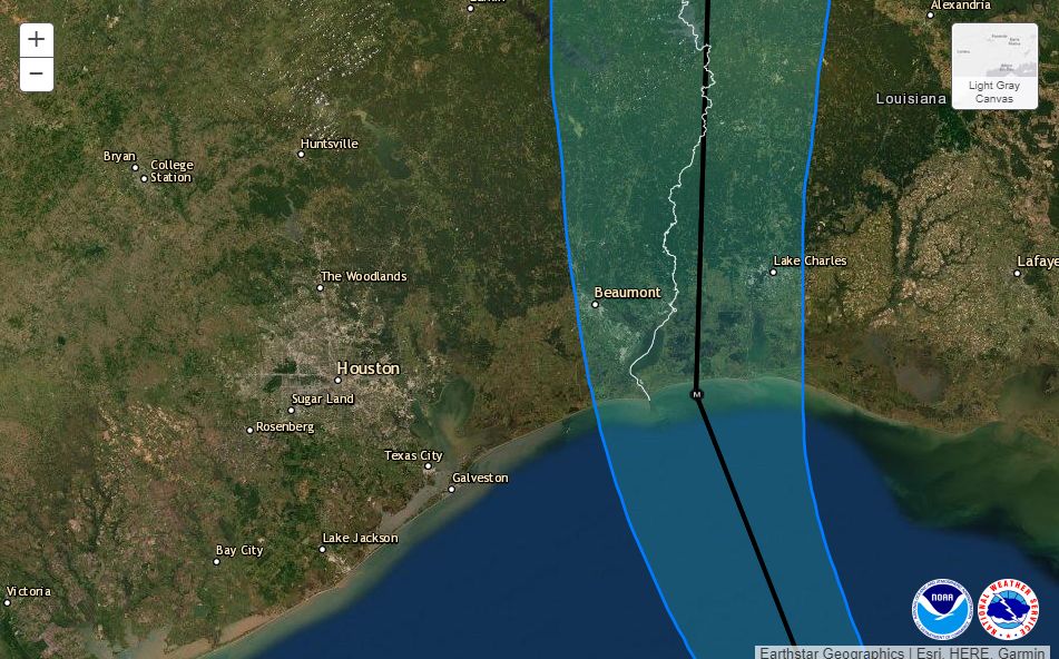
Below you’ll find the National Hurricane Center’s 4 pm CT track update. The track line remains the same, but the cone has moved further away from Houston as it has shrunk. There is high confidence in this forecast track. Laura is turning. It will continue to turn.
4pm CT Wednesday track for Hurricane Laura. (National Hurricane Center)
Power outages
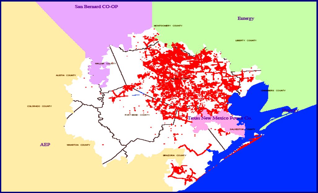
We continue to think the main issue tonight in the Houston area will be power outages due to localized, strong wind gusts that may reach 50 or even 60 mph. Sustained winds will be lower. Our best comparison for this event is Hurricane Rita. According to its financial documents, CenterPoint Energy had 1.9 million customers in 2005, at the time of Rita’s landfall. After Rita, the company reported that 715,000 customers lost power in its greater Houston service area, about 38 percent of customers. This map shows that most of those losses were on Galveston Island and clustered in the eastern half of its service area, as you would suspect.
CenterPoint service area outages immediately after Hurricane Rita. (CNP)
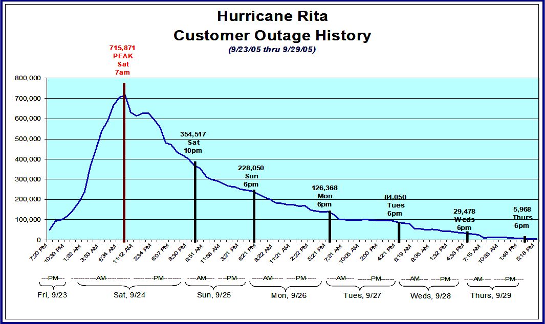
About half of those customers had service restored by 10pm that night, and more than 80 percent had service back by Monday evening, about 2.5 days after the storm’s passage. Nearly all customers had service back within five days.
CenterPoint restoration efforts after Rita. (CNP)
CenterPoint serves about 2.5 million customers in the region now. We don’t think outages will be as severe tonight for a couple of reasons. Although Laura is likely to be stronger than Rita at landfall, it should also be further east than that storm, and also has a smaller field of tropical storm force winds, about 175 miles compared to 205 miles for Rita. So we think there will be fewer gusts in the region, and the wind effects should be shorter lived as Laura continues to scoot along.
Hi, Eric! When crunching your numbers, please keep in mind that we now serve over 2.5 million in the Greater Houston area. Since Rita, we’ve also deployed new tech, such as smart meters and intelligent switching devices, to limit the number and duration of power outages.
— CenterPoint Energy (@CNPalerts) August 26, 2020
Additionally, after Hurricane Ike, CenterPoint began a program to “harden the system” within 35 miles of the Gulf Coast, and this involves changing wooden structures to concrete and steel. However, most of the electricity distribution system is still about 95 percent wood. In any case, it can’t hurt to charge your phone this evening, especially if you live east of Interstate 45, or close to the coast.
Our next post will come no later than 8:30 pm CT.

BillyHoya likes this
26 Aug 16:45
Laura still intensifying, tracking toward southwestern Louisiana
by Eric Berger
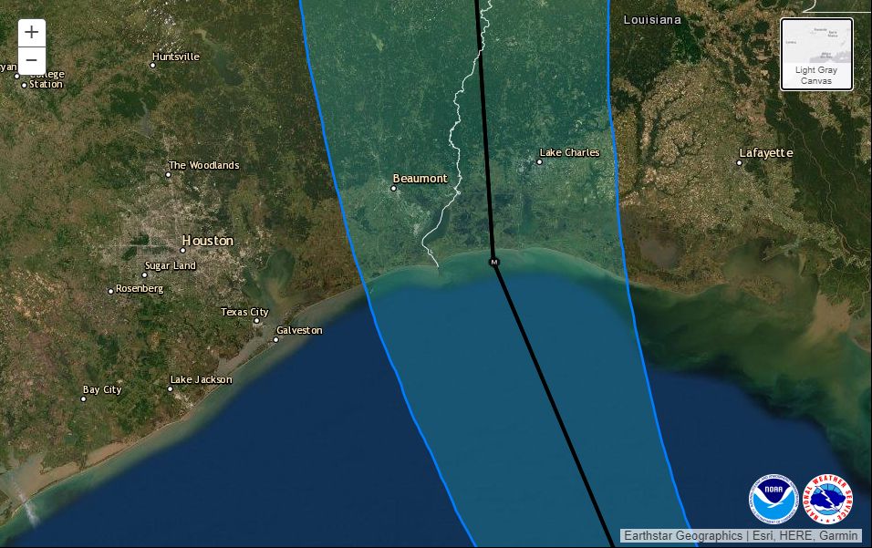
POSTED AT 10:30 AM CT WEDNESDAY: Just a quick, mid-morning update to share the latest information from the National Hurricane Center, and drill down a little bit more into what you should expect tonight, and when, in the Houston area. The storm has unfortunately continued to intensify, now up to 125 mph, and the hurricane center predicts Laura will come ashore as an extremely powerful hurricane with 145 mph winds tonight just east of the Texas-Louisiana border. Forecasters had this sober message for coastal residents near the landfalling storm: “Unsurvivable storm surge with large and destructive waves will cause catastrophic damage from Sea Rim State Park, Texas, to Intracoastal City, Louisiana, including Calcasieu and Sabine Lakes. This surge could penetrate up to 30 miles inland.”
Updated cone and track forecast at 10am CT Wednesday. (National Hurricane Center)
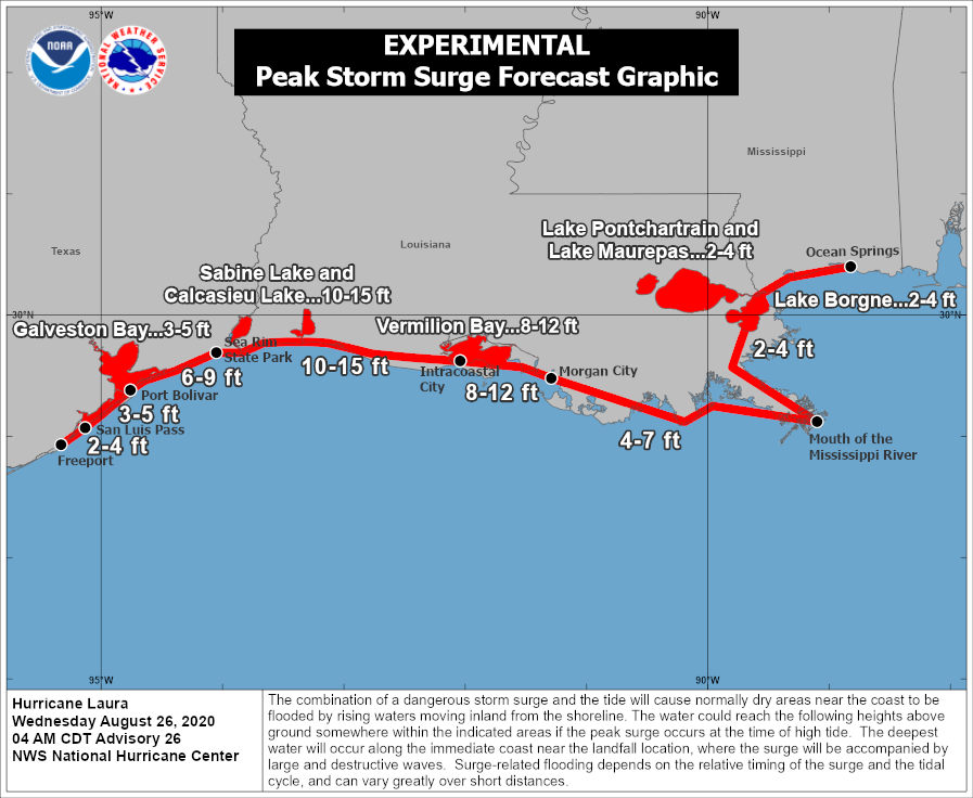
Closer to home, right along the coast, the biggest impact will be storm surge. However, forecasters have backed off their expectations for the Galveston area, slightly, with 2 to 4 feet of surge now anticipated. We still expect low-lying areas on Galveston Island and Bolivar Peninsula to be inundated with water for several hours tonight. Storm surge will get incrementally worse up the Texas coast, and reach its peak east of Laura’s landfall, in Louisiana.
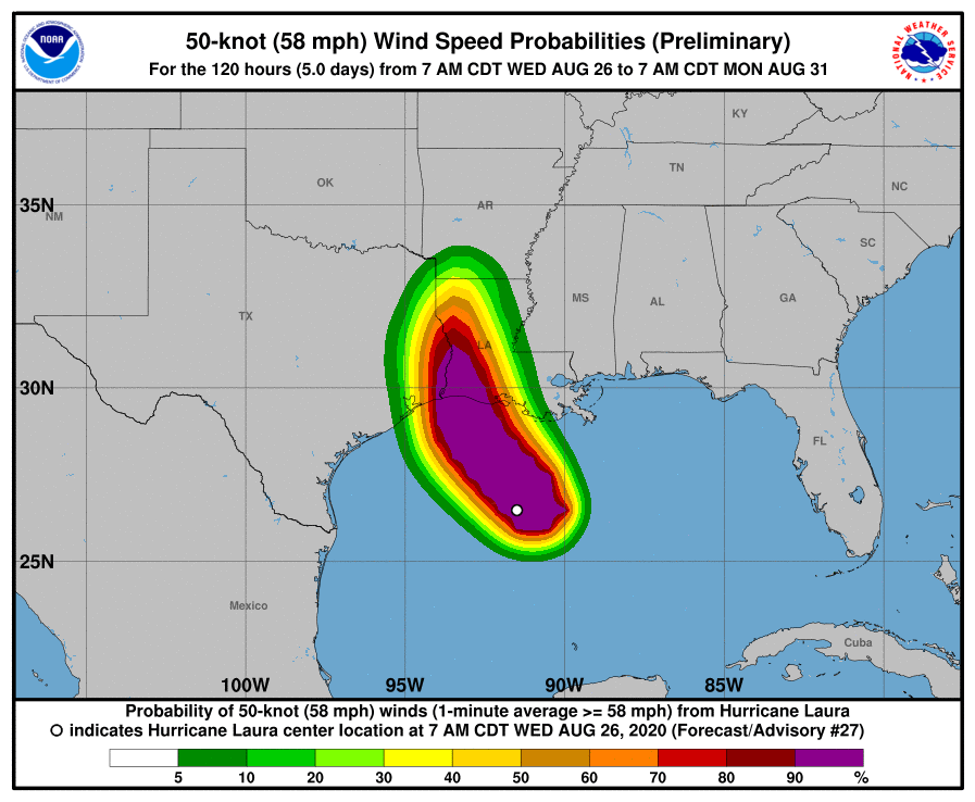
For everyone else, it’s going to be almost all about the wind. Some areas of town are already seeing breezy winds from the northeast, with recent gusts of about 20 mph reported at Hobby Airport. These winds will build this afternoon and evening and likely peak from about 9 pm through 3 am. I anticipate the potential for Tropical Storm-force wind gusts for at least the eastern half of the metro area, with the greatest risk right along the coast. (The National Hurricane Center estimates there is a 6 percent chance of hurricane-force winds in Galveston, and a 21 percent chance in High Island).
Probability of sustained winds of 58 mph or greater due to Laura. (National Hurricane Center)
This morning I mentioned the widespread outages during Hurricane Rita for the Houston metro area. I think that remains the biggest potential for disruption tonight, and you ought to be prepared for at least a short outage. But quite frankly, the storm is now tracking slightly east of where Hurricane Rita came ashore in 2005, and will be turning away from Houston. Yes, Laura is more powerful, but we are nonetheless getting further from its core of stronger winds. This eastward movement may also spare Beaumont and Port Arthur from the storm’s very worst effects, but it is still going to be most dicey. We hope to have better information on this later today.
In terms of rainfall we have no real concerns. There may be some briefly heavy downpours, but the region’s bayous are dry. Accumulations of less than 1 inch are likely west of Interstate 45, with 1 to 4 inches possible on the east side of town, increasing as one nears Beaumont.
Rains and winds from Laura should be rapidly moving away from the Houston area by Thursday morning. Rain chances will linger through the remainder of the week, but it really should be nothing to worry about.
Our next update will come no later than 2:30pm CT.
BillyHoya likes this
26 Aug 16:45
Confidence high in Laura landfall near Texas-Louisiana border tonight
by Eric Berger
POSTED AT 6:50 AM CT WEDNESDAY: Good morning. Hurricane Laura has really intensified overnight, and at sunrise this morning it is a Category 3 hurricane with 115 mph winds. It may peak at 130 mph later today before landfall tonight.
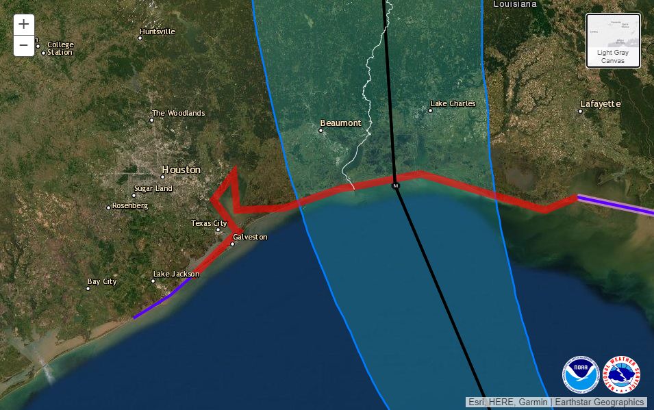
Houston now lies well out of the National Hurricane Center forecast cone (see map below) and it is now clear the Houston-Galveston metro area will escape the worst of what is a powerful Hurricane Laura. We are still going to monitor this storm closely, and we will definitely see some inclement weather in our region later today and tonight—but nothing like the Beaumont, Port Arthur, and Southwestern Louisiana areas will experience as Laura makes landfall near the border between Texas and Louisiana around midnight. This has been a very, very close call for Houston.
Here is a high-resolution view of the 4am forecast track and “cone” for Laura. (National Hurricane Center)
Hurricane Rita
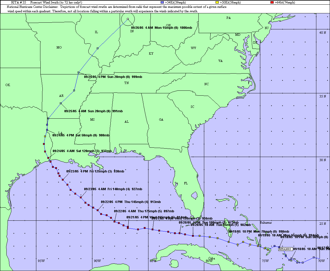
It seems increasingly evident that Hurricane Rita will offer a useful guide for what to expect from Laura. Rita made landfall just east of the Texas-Louisiana border on September 24, 2005, as a Category 3 hurricane with 115-mph winds. This is near the expected landfall strength of Laura (present forecast is 120 or 130 mph). It looks like Laura may track slightly east of Rita’s path inland, but the 15-year-old storm provides a strikingly similar analog.
Track of Rita. Note its shocking intensity (175 mph) just two days before landfall. (NOAA)
So what were the effects of Rita in Houston? This National Weather Service report provides information on wind gusts and rainfall totals from across the region. Winds were the most striking effect. Peak gusts just above 60 mph were recorded at Bush Intercontinental Airport and Galveston Island, with sustained winds of 45 mph. Most of the region briefly saw gusts in the 50s. This was enough to knock out some power on Galveston Island. So I think for Houston, tonight, we should expect to see downed trees and sporadic to widespread power outages. Damages from Rita were estimated at $90 million in Harris County, most due to food losses during outages.
Conditions today and tonight
Now that we finally have a solid handle on Laura’s track and intensity, we can speak with some reasonable confidence about weather as the storm makes landfall around midnight tonight, or shortly thereafter.
Winds
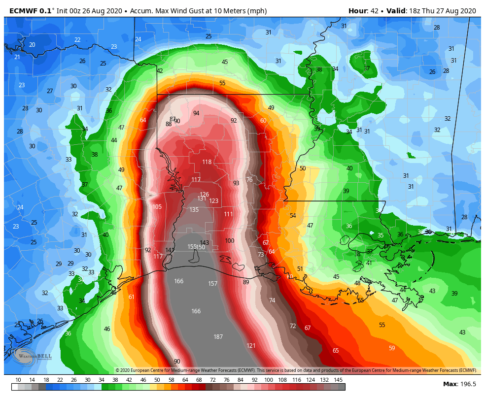
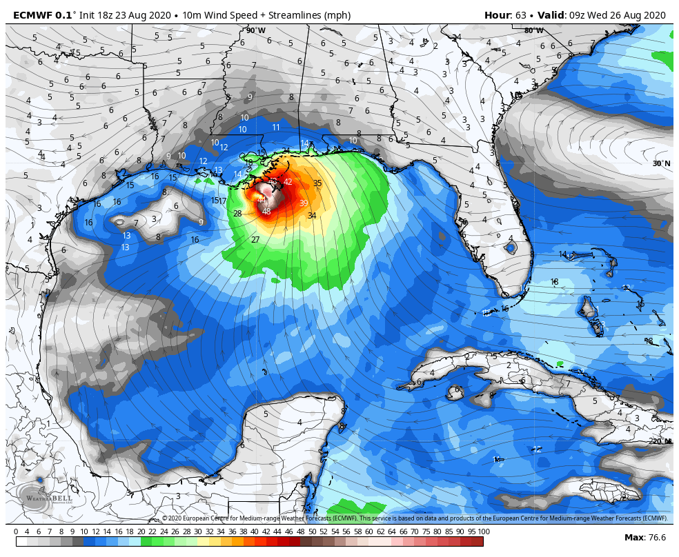
Areas east of Interstate 45 in Houston have about a 50 percent chance of seeing tropical storm-force winds, likely beginning around sunset or a few hours afterward. Areas such as Galveston Bay, Chambers County, and Bolivar Peninsula will see higher gusts. This forecast map, from the European model, provides a reasonable estimate of “peak” wind gusts that can be expected tonight at a level of 30 feet off the ground. Winds at the surface will be about 10 percent less. Under this forecast, Beaumont and Port Arthur would likely miss the storm’s most catastrophic winds, but it’s still going to be nasty, and at this point it’s too close to call. A destructive wind path will continue well inland along Laura’s track.
European model forecast for peak wind gusts from Hurricane Laura. (Weather Bell)
Storm surge
Surge is another major concern as Laura grows larger and more powerful over the Northwest Gulf of Mexico. The following map from the National Hurricane Center estimates the level water could reach above normal levels at high tide.
Storm surge forecast for Hurricane Laura. (National Hurricane Center)
Rainfall
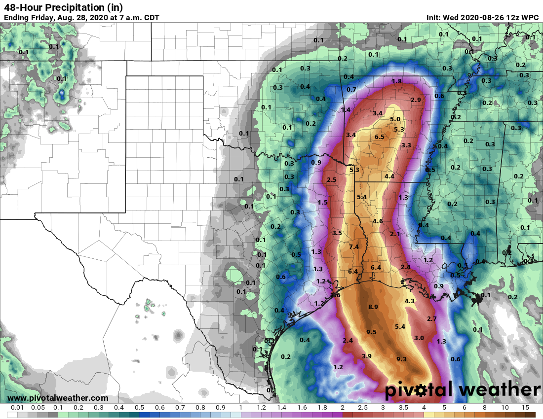
Scattered showers and thunderstorms will likely move into the area from the southeast this morning, and will then spread over the region later today and tonight. Here is the latest estimate for rainfall totals over the next 48 hours.
Rain accumulation forecast for between now and Friday morning. (Pivotal Weather)
Note to readers
We have received so many kind e-mails, comments here, on Facebook, on Twitter and elsewhere that Matt and I cannot reply to them all, at least not in the midst of a frenetic forecasting period like this. But know that we do deeply appreciate you, our readers. Thanks to word of mouth, almost exclusively, we have grown rapidly since starting Space City Weather in late 2015. On Wednesday, alone, we had 1.6 million page views and more than 520,000 visitors to the site. This is more than Matt and I could have hoped, and we are humbled by your appreciation. Really, we are just two nerds with a passion for weather. We’re glad to be able to share that with you, and help in times of crisis, with the support of Reliant. Our philosophy will never change—we’re just trying to make the best possible forecasts amidst the uncertainty. We love the Houston region, warts and all, and it is our pleasure to be able to give something back.
Our next post will come at 10:30am CT.
BillyHoya likes this
26 Aug 11:46
WELCOME TO BUG CITY! HOME OF CHRISTINA RICCI!
by noreply@blogger.com (JerryMaguire)
BillyHoya likes this
26 Aug 11:44

Click here to go see the bonus panel!
Today's News:
Saturday Morning Breakfast Cereal - Dragonfly
by tech@thehiveworks.com
Click here to go see the bonus panel!
Hovertext:
If you guess it and you are pretty sure it's a good guess, that's two data points.
Today's News:
BillyHoya likes this
26 Aug 06:09
Tonight's comic is trying to get less angry.

Tonight's comic is trying to get less angry.
BillyHoya likes this

24 Aug 21:07
Laura moving near Cuba, confidence increases slightly in track forecast
by Eric Berger
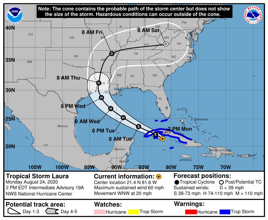
I will not lie. (We never do, and that’s a promise you can bank on). When the National Hurricane Center issued its updated track forecast at 10 am CT this morning I had my doubts. Forecasters there seemed too conservative in not moving the track of Laura closer to Houston, as that is where a lot of the model data indicated it would go. However, in going over all of the just released data from 12z models, their track forecast (shown below) now looks pretty good. So, kudos to the pros in Miami.
Monday 10 am CT forecast from the National Hurricane Center.
What does the 12z data show? Several models have made slight adjustments eastward today, but the most significant movement has come from the UKMET model, produced by the United Kingdom. This is not the world’s best global forecast model, but it is competitive, and something we often look at. In the case of Laura, it has had some of the best performance to date since tracking began a few days. This meant we have weighted it a little bit higher for this storm.
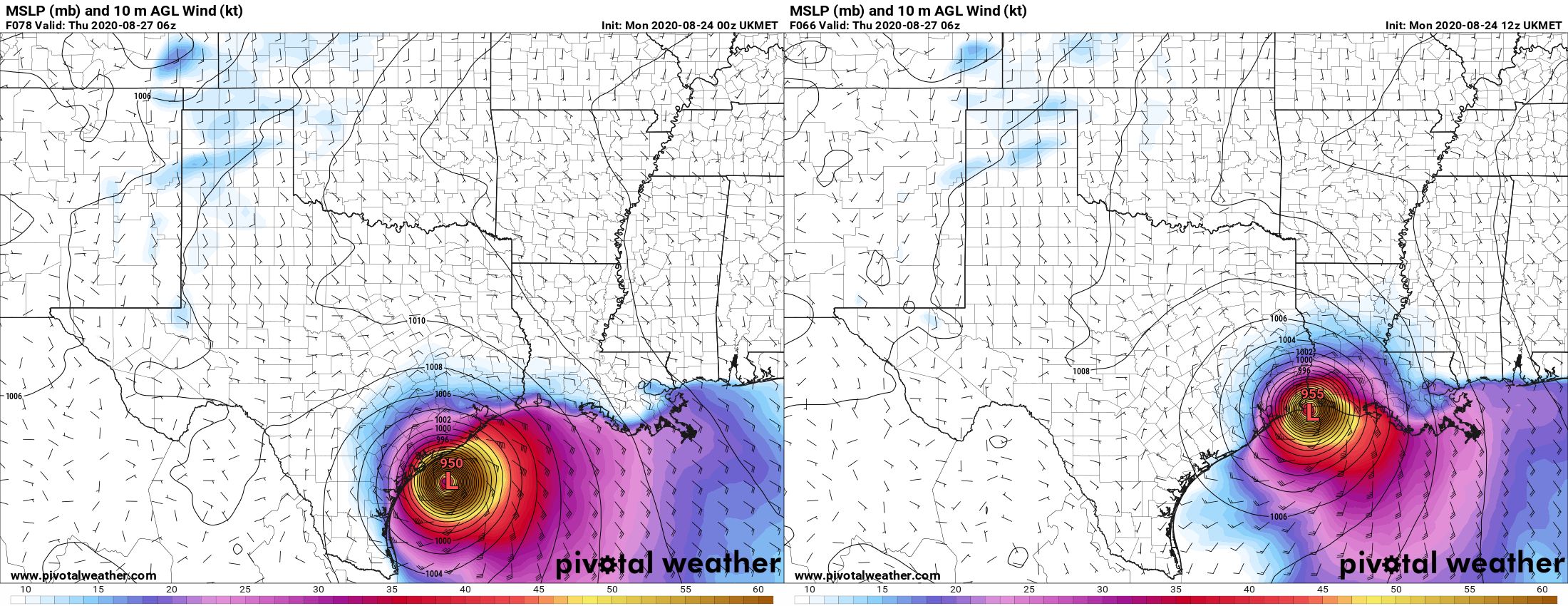
One of the things that has concerned us is that the UKMET, although an outlier, had been frequently bringing Laura to the central or upper Texas coast. This would have placed Houston, Galveston, and the upper Texas coast on the powerful right side of the storm. However, in a just released run of the model, the storm’s landfall location has made a sizable jump east, from near Corpus Christi to the Texas-Louisiana border:
A plot of the UKMET model released early Monday morning (left) compared with the latest run from Monday early afternoon. (Pivotal Weather)
This brings the UKMET more in line with other global models in predicting a landfall near the Texas-Louisiana border, or slightly east of there. This gives us more confidence in a solution that brings Laura onshore just far enough east of Houston to keep the worst of its winds, waves, and rains away from the area. But this does not mean the track forecast is locked down—we still have a fair amount of uncertainty there. There are some very fine details in the positioning of several features in the upper atmosphere, and these could easily move a bit in the next day or so. That would be enough to nudge the forecast back toward Houston. So please, do not let your guard down and keep making preparations. But maybe, breathe slightly easier if you live in Houston. If you live in Beaumont or points east, the threat remains very high.
One thing I think we can answer is when we should have clarity on what Laura is really going to do. I am reasonably confident that the track will be dialed in by this time tomorrow, after Laura has come across the western edge of Cuba and emerged into the Gulf of Mexico. By this time it should be forming a more well defined center of circulation, and the models will have ingested better initial conditions. So our long, uncertain wait for some answers should finally come to an end within 12 to 24 hours. As ever, thank you for your patience.
To update the percentages I’ve been using for various scenarios, this is what I would now go with:
Scenario One: Near or direct impact on Houston by a powerful hurricane. (30 percent)
Scenario Two: Powerful hurricane near or east of Texas-Louisiana border (70 percent)
Scenario Three: Weaker storm, central or southeastern Louisiana (~0 percent)
I will be conducting a Facebook Live video at 2pm CT that you can find on our page there. Matt will provide our next update no later than 9pm CT tonight.

BillyHoya likes this


24 Aug 18:12

Click here to go see the bonus panel!
Today's News:
Saturday Morning Breakfast Cereal - Monolith
by tech@thehiveworks.com
Click here to go see the bonus panel!
Hovertext:
I am prepared to vote for this form of government.
Today's News:
Lani Evitts, Alex and 2 others like this

24 Aug 10:36

WSJ: Mark Zuckerberg used a private Trump meeting to hurt TikTok
by Daniel Cooper
Mark Zuckerberg may have used a private meeting with Donald Trump to push for the US to attack TikTok, writes the Wall Street Journal. During his visit to Washington DC late last year, the Facebook CEO made both public speeches and private exhortations about the threat posted by its rival. The paper notes that it was after meeting Zuckerberg that senators began raising concerns about TikTok’s safety.
A spokesperson for senator Josh Hawley implies that TikTok is being used to distract from Facebook’s own regulatory concerns and to get lawmakers to crush a rival. Kelli Ford is quoted as saying that Facebook’s alarmism is a “PR tactic to boost its own reputation.” The report adds that Facebook spends record amounts on lobbying, and has launched an advocacy group, American Edge, to boost US tech firms in DC.
TikTok has, for its part, pointed accusatory fingers at Facebook, saying that it’s trying to use politics to damage a rival. In July, CEO Kevin Mayer published an open letter calling Facebook out for launching a “another copycat product [...] after their other copycat, Lasso, failed quickly.” Mayer added that Facebook was launching “maligning attacks by our competitor -- namely Facebook -- disguised as patriotism and designed to put an end to our very presence in the US.”
BillyHoya likes this
24 Aug 10:10

New comic!
Today's News:
Awkward Zombie - Survival of the Cutest
by tech@thehiveworks.com
New comic!
Today's News:
You knew your days in this society were numbered when you decided to go with the tiger-print tanktop.
BillyHoya likes this

24 Aug 02:36
Laura now grazing Cuba, set to threaten Texas and Louisiana by mid-week
by Eric Berger
Good evening. I’d like to welcome our new readers to the site—whether you found us through a friend or family member, Google, Facebook, Twitter, Instagram, or of course our MySpace page. Just kidding about the last one, sorry Tom. Anyway, if you don’t want to miss our updates, you can subscribe to our email list in the box on this page. Doing so sends you our complete posts immediately after publication (and nothing else).
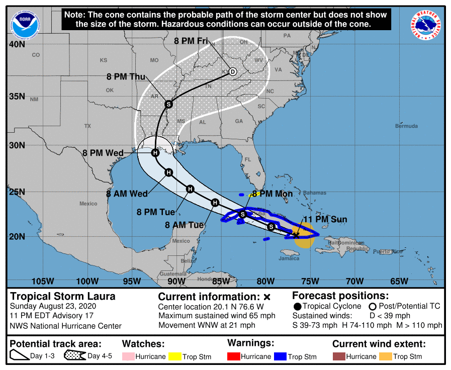
Alright, on to the forecast. We’re still really struggling with the evolution of Tropical Storm Laura, and a large part of the uncertainty involves the movement of its center over, or just south of Cuba the next day or so. Laura does not have a particularly well defined center and its interaction with the island may cause the center to re-form. Any of these perturbations could have implications for the storm’s track downstream. This is one reason why the models are struggling with how to handle Laura’s ultimate path.
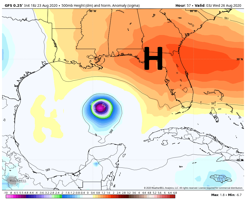
The strength of the southeastern ridge, shown above, will determine Laura’s track. (Weather Bell)
Another factor is Marco, which we still don’t think will have a sensible effect on weather in the Houston metro area. It seems likely that a “stronger” Marco, maintaining hurricane strength on Monday as it nears the Louisiana coast, would amplify a ridge of high pressure over the southeastern United States. This would push Laura more westward, toward Texas. However, a weaker Marco would probably allow for Laura to follow a more northwest track across the Gulf of Mexico, toward Louisiana. These, and more details, are the reasons why overall confidence in Laura’s track remains low. Because of this uncertainty I thought it might be helpful to outline three scenarios that I think are possible, along with their likelihood of happening.
Scenario One (30 percent)
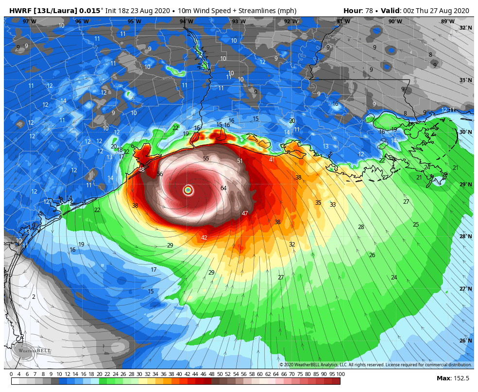
In this scenario the ridge of high pressure remains strong, and drives Laura toward Matagorda Bay or Galveston Bay very late on Wednesday, or early Thursday. This would allow for maximum time over the warm Gulf of Mexico, and we could see Laura coming ashore as a powerful Category 2, 3, or even 4 hurricane. This obviously would be a very bad deal for Galveston, Houston, and points east in terms of storm surge and winds. This would necessitate coastal evacuations and lead to widespread power outages, among other problems. Rainfall would be less of a concern because we expect Laura to scoot through fairly rapidly.
The HWRF model shows a strong hurricane approaching Galveston Bay at 7pm CT Wednesday. (Weather Bell)
Scenario Two (50 percent)
In this scenario, which is basically the “skinny black line” on the National Hurricane Center’s forecast, a reasonably strong Category 2 Hurricane comes ashore near the Texas-Louisiana border, or just east of there. In this scenario Houston sees some briefly gnarly winds, possibly gusting to hurricane force on the east side of the city. But beyond some relatively short-lived power outages, conditions should not be too extreme in the metro area. This would, of course, be a bad storm for Beaumont and southwestern Louisiana.
The 10 pm CT official track from the National Hurricane Center shows landfall just right of “Scenario Two.”
Scenario Three (20 percent)
In this case Laura comes off Cuba and begins moving almost due northwest, toward New Orleans and southeastern Louisiana by late Tuesday night or Wednesday morning. With less time over the Gulf this is a weaker storm. Houston would see almost no significant impacts from such a scenario, but it could cause significant surges or flooding in New Orleans, Mississippi and Alabama.
European model depiction of Laura at 4am CT Wednesday. (Weather Bell)
For the last two runs the deterministic output from the European model has more or less depicted this third scenario, along with the Canadian model. For this reason we can’t entirely discount it.
We hope to have better answers for you tomorrow on all of this, when we’re going to reach the point when final decisions on evacuation and other preparation activities will need to be made for the metro area.
Our next update will be no later than 8:30 am CT.
BillyHoya likes this
23 Aug 18:06

Click here to go see the bonus panel!
Today's News:
Saturday Morning Breakfast Cereal - Humans
by tech@thehiveworks.com
Click here to go see the bonus panel!
Hovertext:
It turns out the truly weird people are the ones who want to stay behind on Earth.
Today's News:
Shortfatsteve, Lucas Vigroux and 2 others like this
22 Aug 16:58

Click here to go see the bonus panel!
Today's News:
Saturday Morning Breakfast Cereal - Candyland
by tech@thehiveworks.com
Click here to go see the bonus panel!
Hovertext:
The kids once created a practically unwinnable version of Candyland and played joyously for most of a day. How I envy them.
Today's News:
BillyHoya likes this
22 Aug 14:38
Marco, Laura poised to threaten the Gulf of Mexico next week
by Eric Berger
Good morning. We still are trying to parse details about tropical storms Marco and Laura, and we still don’t have solid information about what will happen. The bottom line is that, from Monday through Friday, the greater Houston region needs to be prepared for the potential of tropical weather—from heavy rainfall, to storm surge and strong winds. None of these are guaranteed, and there is no cause to evacuate now. But you do need to be prepared for rapidly changing forecasts.
Tropical Storm Marco
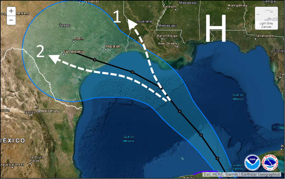
It appears that Marco has begun to intensify further overnight, and the storm has 50 mph sustained winds. If Marco continues to strengthen further this weekend, up to hurricane strength, it likely will take a more northerly track, toward southeastern Louisiana. However a weaker storm is more likely to move more westward, toward the central or upper Texas coast. Why? Because a stronger storm might have more impetus to barrel into building high pressure over the southeastern United States, whereas a weaker one would be more steerable to the west. Here’s a map showing the National Hurricane Center forecast track (in black) along with a couple of scenarios:
A map of the 4am CT National Hurricane Center track for Marco with two scenarios.
Scenario One, in which Marco never really makes a leftward turn while over the Gulf, would lead to limited impacts for the Houston metro area and the potential for heavy rainfall in southern Louisiana. Scenario Two will bring a decent amount of rainfall to the Houston region—2 to 6 inches, maybe?—along with elevated tides. At this point I would weight these two scenarios equally, in terms of probability.
Because there is so much uncertainty in the track and intensity, projecting other effects such as a storm surge is sort of fruitless. However, probably a worst case scenario is seas about six feet higher than normal along Galveston by late Monday. Peak winds, of tropical storm strength, would likely arrive here by late Monday. All of this is subject to change. All of this.
Tropical Storm Laura
Oh, we have many questions about Laura as well. At present the system is fairly disorganized, and contending with its “center” moving over Puerto Rico. What happens over the next 24 to 48 hours will probably have important implications how how menacing Laura ultimately becomes when it moves into the Gulf of Mexico. Here’s what I mean by that:
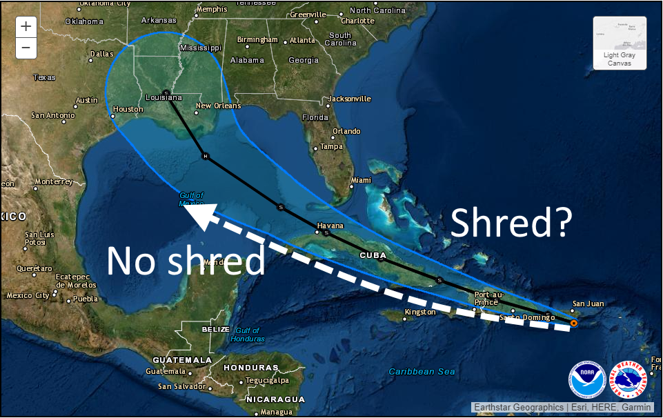
4am CT Saturday forecast track for Hurricane Laura.
Along the current National Hurricane Center track (shown in black) Laura will traverse the mountainous terrain of Hispaniola, followed by the spine of Cuba. If the system is already a struggling tropical storm, it is difficult to see how a particularly organized system emerges into the Gulf of Mexico. Therefore the threat of Laura becoming a hurricane next week diminishes. However, if the storm can find a track just south of the islands, then it has a chance to escape the shredder and move into the Gulf later on Monday poised to intensify.
In terms of track, anything is still possible. Under the “no-shred” track above, Texas would probably be threatened by a hurricane next Wednesday or Thursday. Under the shred track, a weaker system probably comes toward Louisiana. But our confidence in a track remains very low.
We will next update the site by 3pm CT.
BillyHoya likes this
22 Aug 14:32
 The storm emerges over the eastern Atlantic in late August, first as a slow-moving tropical system that remains largely unnoticed in faraway Texas. It gains power as it drifts westward into warmer Caribbean waters, lashing island coastlines and leaving a trail of destruction in its wake. By the time the storm enters the Gulf of Mexico and churns toward the southeast corner of Texas, it has transformed into a category 4 hurricane with 130-mile-per-hour winds that fan out for 200 miles in every direction. Unlike 2017’s Hurricane Harvey, which made landfall just north of Corpus Christi, the swirling behemoth slams into land some two hundred miles up the coastline near Galveston Island. As the hurricane moves inland, it functions like a giant wall of wind,…View Original Post
Why One Expert Predicts a Major Hurricane Hitting Houston Would Be “America’s Chernobyl”
by Peter Holley
The storm emerges over the eastern Atlantic in late August, first as a slow-moving tropical system that remains largely unnoticed in faraway Texas. It gains power as it drifts westward into warmer Caribbean waters, lashing island coastlines and leaving a trail of destruction in its wake. By the time the storm enters the Gulf of Mexico and churns toward the southeast corner of Texas, it has transformed into a category 4 hurricane with 130-mile-per-hour winds that fan out for 200 miles in every direction. Unlike 2017’s Hurricane Harvey, which made landfall just north of Corpus Christi, the swirling behemoth slams into land some two hundred miles up the coastline near Galveston Island. As the hurricane moves inland, it functions like a giant wall of wind,…View Original PostThe post Why One Expert Predicts a Major Hurricane Hitting Houston Would Be “America’s Chernobyl” appeared first on Texas Monthly.
21 Aug 18:16

Click here to go see the bonus panel!
Today's News:
Saturday Morning Breakfast Cereal - Funding
by tech@thehiveworks.com
Click here to go see the bonus panel!
Hovertext:
That's just professor hair, not an affectation.
Today's News:
Lani Evitts, Julia Meyer and 5 others like this
21 Aug 15:37
Friday Fiction – Blood Brothers
by Holly
 Blood Brothers
Price
1976
Submitter: This cover is… wow. I’m currently weeding my public library’s adult fiction collection. This particular book last checked out just five years ago in 2015, surprisingly enough. This appears to be a first edition from 1976, and the address stamped in the front of the book is from three library locations ago! The description on the dust jacket begins: “The De Cocos of Co-op City are a family of hard hats who think with their hands and kill with their love.” Judging by the Goodreads reviews, this was a pretty popular book at the time and was made into a movie. Dwindling circulation, a seriously dated cover, and poor condition mean it’s time for this classic to go. One of my co-workers described the cover as “A depressed Freddie Mercury-Sylvester Stallone amalgam is comforted by a younger Paul Dooley as Judd Hirsch looks on.”
Holly: Spot on.
The post Friday Fiction – Blood Brothers appeared first on Awful Library Books.
BillyHoya likes this