Thirty-nine teams competed for the prized Gold Bucket award. The team led by Zeigler Cooper Architects and Paradigm Construction took home the top prize with the Architect Insane Asylum design.
While I never used these bikes, Herman and other parks were full of people on them. I'm sad to see them go.
METRO's board of directors last September approved the $10.5 million agreement with Canada-based PBSC Urban Solutions, a company that has bolstered successful bike share programs in New York, Chicago and Boston.
The city’s minimum wage will increase from $15 to $18 over the next two years. Retirees over the age of 60 will be able to retain city insurance for five years or until Medicare eligibility.
Potential Tropical Cyclone 9 is likely to become a depression and/or tropical storm by tonight or tomorrow morning.
It will accelerate north toward the coast of Florida, with a landfall likely on Thursday somewhere between Pensacola and Tampa. Hurricane impacts will spread across Florida’s west coast and Panhandle.
PTC 9 or Helene is expected to be a significant storm and potentially a major hurricane (cat 3+).
Because of fast forward motion, PTC 9 or Helene will spread damaging wind far inland from the coast, across South Georgia, possibly into the Atlanta area (depending on track) and into the Carolinas.
PTC 9/Helene will be a significant, disruptive storm for the Southeast Thursday, Friday, and possibly beyond.
Give our site a bookmark and check back in later today and/or tonight for some additional updates to this post.
Potential Tropical Cyclone 9
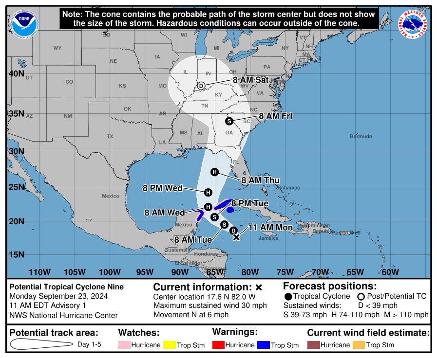
The forecast track for PTC 9 suggests a storm tonight or tomorrow morning, and a hurricane by Wednesday, with impacts beginning in Florida by Thursday. (NOAA NHC)
We have our potential tropical cyclone now, and it will be known as PTC 9. Expect this to formally become a depression later today and a tropical storm tonight or tomorrow morning. This should take on the name Helene.
The first forecast track from the NHC is very much in line with strong model consensus right now, which takes Helene somewhere between about Pensacola and Tampa, with the majority of guidance favoring the Panama City to Cedar Key corridor, close to the Big Bend of Florida. One thing to be very, very clear about: There is still a fair bit of spread among individual ensemble and tropical model members. You can use the slider here to compare the 6z runs of the European and GFS ensemble member forecasts for Thursday around midnight.
The 6z European ensemble (white background) and GFS ensemble show clustering of tracks in the Panama City-Cedar Key corridor with some tracks as far southeast as Sarasota or Fort Myers and some back closer to Pensacola. (Weathernerds.org)
The latest tropical models are very clustered on the west side of Apalachee Bay, with a track very near Tallahassee once inland. So you can see that the model guidance is in great agreement right now on the broad picture of things. I would still watch this very closely in Tampa and Sarasota, as well as Pensacola, as those locations are in the “margin of error” as you might say.
There is also a fair bit of cross-track spread in timing, with some models showing landfall as early as Thursday afternoon and others more into Thursday night. Assume you have until Thursday morning to finalize your preparations on the coast. Anything beyond that is just proverbial icing on the cake.
PTC 9’s intensity outlook
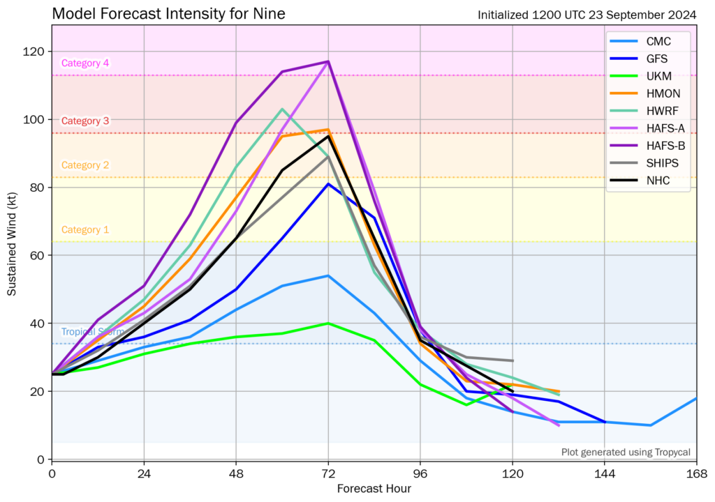
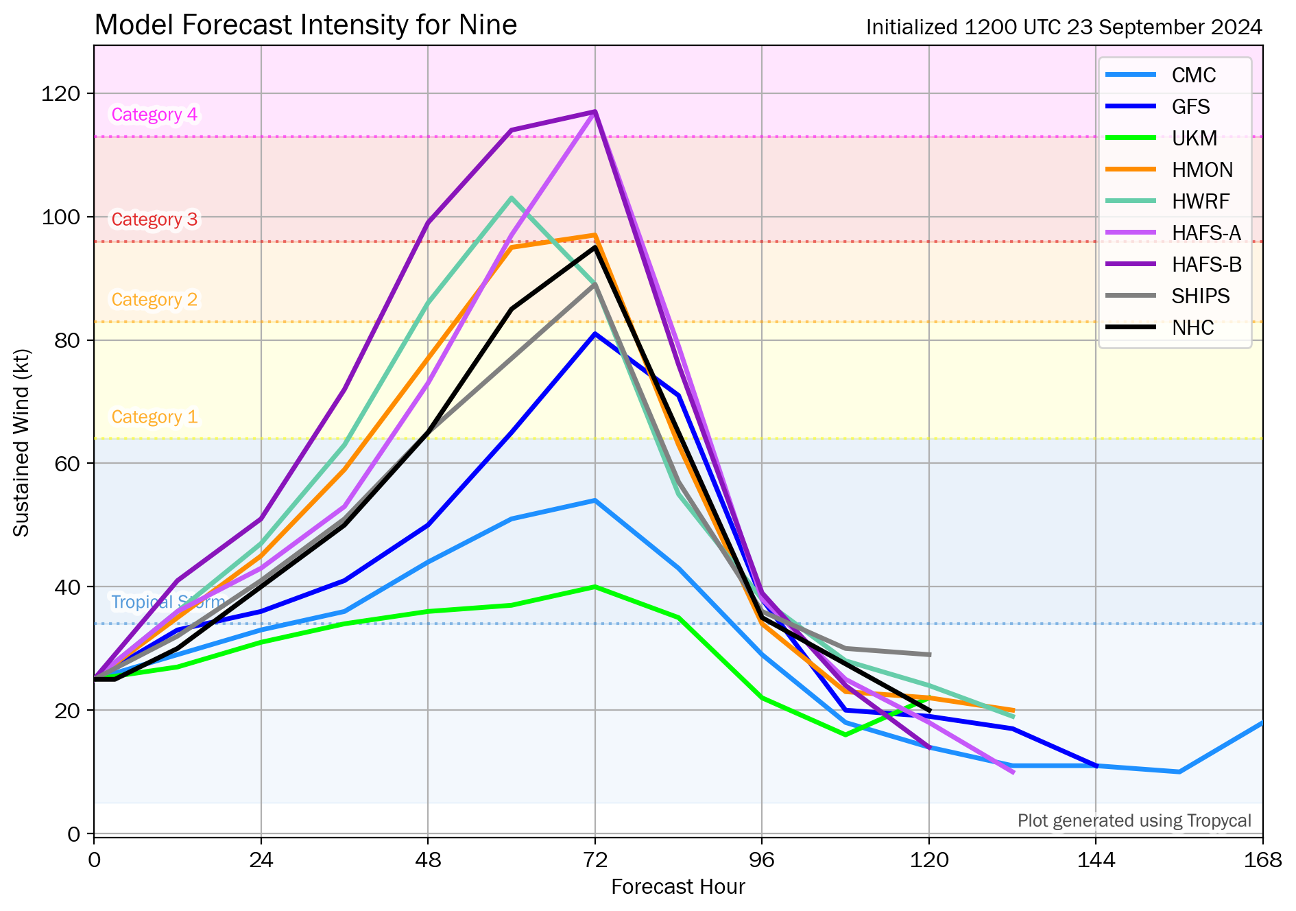
One thing we are unfortunately continuing to be confident in is that this storm has a high ceiling in terms of intensity. There remains a significant spread within tropical model guidance with intensity, as some models suggest tropical storm intensity, while others are at the top end of major hurricane intensity, perhaps a higher end cat 3 or cat 4.
Model guidance shows a substantial spread in intensity forecasts with a handful just at tropical storm intensity, while some more hurricane-focused models show high end Cat 3 or Cat 4 potential. (Tomer Burg)
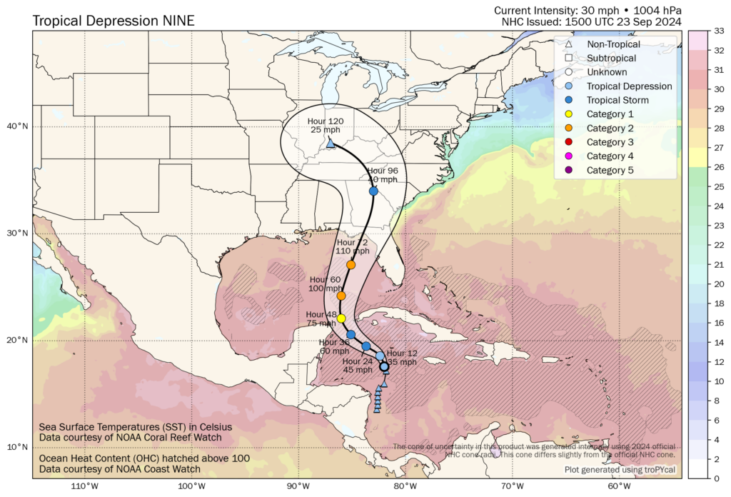
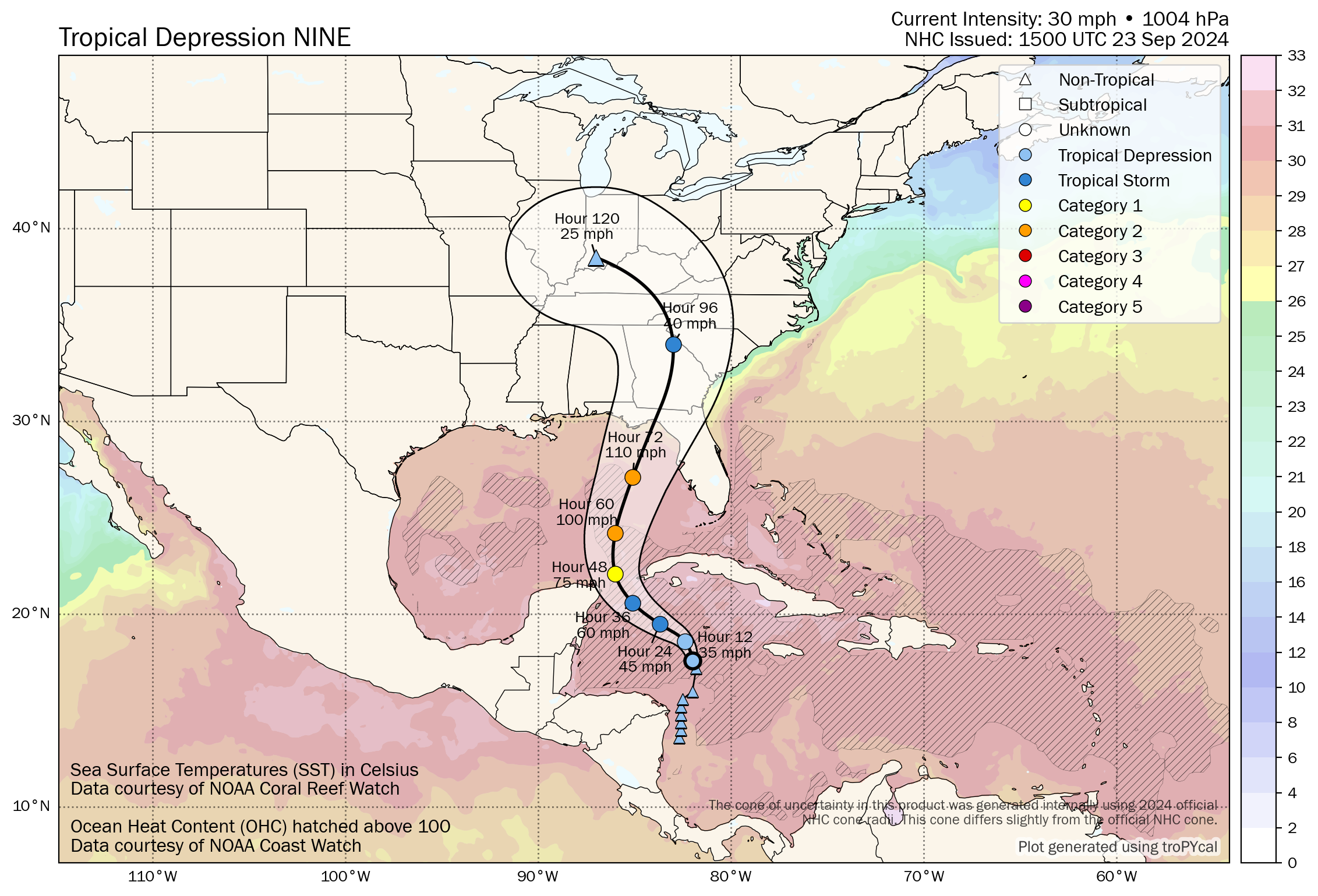
The NHC projecting a peak intensity of around 110 mph, just on the cusp of major hurricane strength is a good place to be right now, but do realize that the risk for a stronger storm is very much on the table. As we’ve been noting, this track is about the worst possible one a storm could take from a “fuel” standpoint in the Gulf of Mexico. PTC 9 is likely to travel over significant ocean heat content the majority of its life cycle, and water temperatures never really cool off much on approach to landfall. Given the anticipated forward speed of PTC 9, we are likely to see this storm come ashore at or near peak intensity.
The forecast track from the NHC underlaid by ocean heat content and water temperatures shows a storm that is likely to spend most of its time over some of the warmest water in the Gulf or Atlantic. (Tomer Burg)
Folks in Florida should be preparing for a major hurricane impact in the Big Bend or Apalachee Bay with all the threats you’d expect: Surge, wind, waves, flooding, etc. This has the potential to be as bad or worse than Idalia and much worse than Debby in the Big Bend.
Inland risks
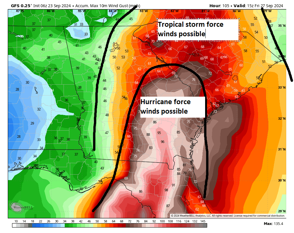
The threats from PTC 9 are going to extend much farther inland than usual. The storm will be hauling as it moves inland. Even if it comes ashore weaker than forecast right now, it is likely to carry tropical storm and hurricane force winds well inland from the coast. Those impacts should begin Thursday night and continue much of Friday. This includes much of South Georgia, as well as possibly South Carolina, north Georgia, and portions of North Carolina or Tennessee. The map below shows wind gusts as forecast by the GFS model earlier today. Keep in mind that the final track will determine exactly where those winds occur. A track closer to Tallahassee will shift this farther west. A track closer to Cedar Key will shift this a little to the east.
Tropical storm force winds are likely to extend far inland from PTC 9, with widespread wind damage possible across Georgia and into South Carolina. (Weather Bell)
This is important because this type of scenario could mean widespread, significant power outages and wind damage across Georgia and South Carolina. Metro areas, including Tallahassee, Atlantic, Macon, Savannah, Columbia, Charleston, Greenville-Spartanburg, and Charlotte should be prepared for this scenario and prepare with at least a few days of food and water should this come to fruition.
In addition, heavy rainfall will occur with PTC 9, and flash flooding will be possible, especially in mountainous areas well inland from landfall.
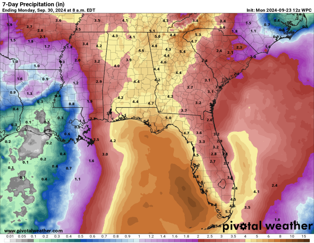
Significant rainfall is likely well inland from landfall with PTC 9, and flash flooding is likely. Thankfully, the forward speed may help mitigate total rainfall a bit. (Pivotal Weather)
This is going to be a significant, disruptive storm for portions of Florida and the Southeast U.S., in addition to perhaps western Cuba and the Cayman Islands where 10 to 12 inches of rain may fall. Impacts will be widespread and damage could be significant. Folks should begin preparing immediately and follow forecast changes closely in the days ahead.
Amalia Mesa-Bains is known for transforming the art of the altar. While some of her earlier pieces follow more traditional altar practices, over time her work has expanded the concept of what an altar can be. Archaeology of Memory is a beautiful retrospective organized by María Esther Fernández, the Artistic Director at the Cheech Marin Center for Chicano Art & Culture of the Riverside Art Museum, and Laura E. Pérez, Professor of Chicanx, Latinx and Ethnic Studies and Chair of Latinx Research Center, UC Berkeley. The show debuted at the Berkeley Art Museum and Pacific Film Archive in February 2023 and has since been presented by El Museo del Barrio and the Phoenix Art Museum. The current iteration is at the San Antonio Museum of Art.
As you might imagine from the title, Archaeology of Memory is a deep and rich exhibition layered with personal ephemera as well as found, natural, and crafted objects. Walking into each room is like walking into a new world, though there are strong themes that connect the spaces, most notably the idea of larger-than-life women who refuse to be contained by the restraints of society. As the mother of a strong-willed daughter, it was therapeutic to see these depictions and learn the stories behind the works.
Amalia Mesa-Bains, “Circle of Ancestors,” 1995, mixed media installation including candles and seven hand-painted chairs with mirrors and jewels, 168 inches diameter. Photo: Raul Rodriguez
Because the show is so bountiful, there are a multitude of rabbit holes one could dive into and perspectives from which to view and consider Mesa-Bains’ oeuvre. With this in mind, I narrowed in on one particular idea rooted in her 1995 work Circle of Ancestors.
Amalia Mesa-Bains, “Circle of Ancestors,” 1995, mixed media installation including candles and seven hand-painted chairs with mirrors and jewels, 168 inches diameter. Photo: Raul Rodriguez
The altar installation features a circle of eight chairs, each representing a female figure, including relatives of the artist, Judy Baca, an anonymous migrant worker, and the artist herself. Each chair back has been replaced with a mirror, and in Mesa-Bains’ unique style, from behind each mirror an image emerges. Each chair seat is adorned with objects. At the center of the circle, a dozen of lit candles sit on the floor. The environment evokes a sense of convening; a gathering for dialogue in a space with a spiritual undertone.
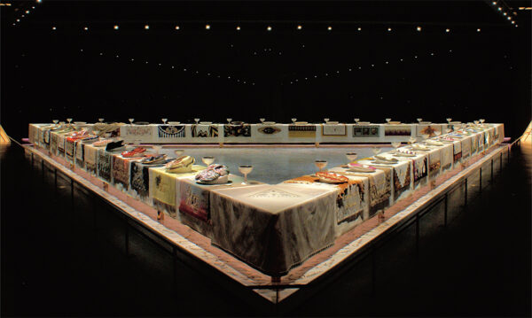
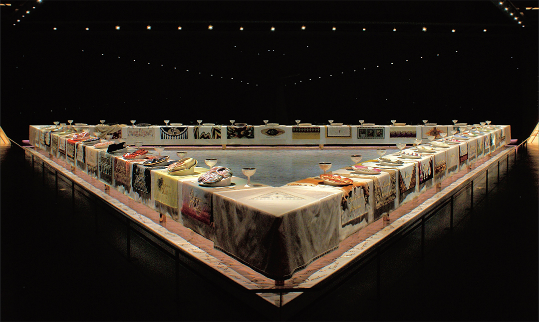
As I stood in front of the work Judy Chicago’s The Dinner Party, came to mind. Last year I wrote about Chicago’s piece in relation to contemporary North Texas women artists working in themes of women’s societal roles and how society treats women. But, what connects Chicago’s piece to Mesa-Bains’ Circle of Ancestors is that both works honor important women and set a space for them to gather. However, where Chicago has set a formal and intricate space, Mesa-Bains has created an informal, communal space, in part by removing the table altogether.
The phrase “a seat at the table” comes to mind… a phrase often used by historically excluded groups who have been systematically and systemically kept from positions of power. But rather than demanding a seat at a table that was never meant for us, Mesa-Bains prompted me to consider if we should be asking the larger question of “Do we even need the table?”
Amalia Mesa-Bains, "Venus Envy I (or The First Holy Communion Moments Before the End)," 1993/2022. Photo: Raul Rodriguez
Amalia Mesa-Bains, “The Library of Sor Juana Inés de la Cruz from Venus Envy Chapter II: The Harem and Other Enclosures,” 1994/2021. Photo: Raul Rodriguez
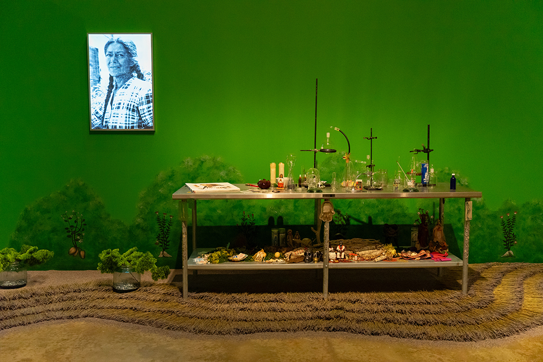
Amalia Mesa-Bains, “Venus Envy Chapter IV: The Road to Paris and Its Aftermath, The Curandera’s Botanica,” 2008/2023. Photo: Raul Rodriguez
What is the function of a table? Various tables show up throughout Mesa-Bains’ installations: a vanity, a table for one person to engage in self-care; a desk, a table for one person to engage in research and scholarship; a laboratory table, a table intended for experimentation. Yet curiously, at this circle where voices come together, there is no table. I think of all of the formal meetings I have had in workplaces, where the table serves as a functional object on which to present information or to take notes, but in another sense, it acts as a barrier between people. Chicago’s Dinner Party, while beautiful and impactful, ultimately has a finite number of place settings. Mesa-Bains’ Circle of Ancestors, has the ability to expand over time, one need only pull up their own chair to join the conversation.
Amalia Mesa-Bains: Archaeology of Memory will be on view at the San Antonio Museum of Art through Sunday, January 12, 2025.
It's refreshing to know there are some places where Canadian Tourist are just as hated as US Tourist ...
Are your local vacation pics not generating enough hate online? Are you feeling stuck in a rut of angering only your neighbours and want to try getting yelled at by different cultures in exotic locales? If you have more money and time than you have shame, here are a few vacation spots for those looking […]
“‘I will protect women at a level never seen before. They will finally be healthy, hopeful, safe and secure,’ Trump said. ‘Their lives will be happy, beautiful, and their lives will be great again. So women, we love you. We’re going to take care of you.’ The former president said women won’t have to think about abortion because decisions about regulating it are now left to the states.” — Los Angeles Times, 9/21/24
- - -
The people of Dune are thirstier, sandier, less safe in the dunes, and unhappier now than they were four years ago. I am also unhappier now than I was four years ago. That’s the last time I ruled this planet, or, as you may recall, the last time Dune (or “Arrakis” to be “politically correct”) was great, again.
Things have fallen apart since I was deposed. Everyone says so. All of the Great Houses of the Landsraad agree with me. Some of the Bene Gesserit too. I’m friends with many of them. Wonderful women. They actually wanted my daughter to join their order, but she’s allergic to Gom Jabbar and other foreign substances.
But I will fix everything fast, and at long last, this interstellar nightmare will be over.
To the people of Dune, here is my promise to you: You will be happy and hydrated once again, just like you were four years ago. You will no longer be thinking about water. And no offense, you people are a bit obsessed. I like water, but have you tried Diet Coke? If I had ten grams of spice for every time I had to hear one of you drone on about “reclaiming water” and “dying of dehydration,” I wouldn’t be running an intergalactic election, if you know what I mean. (I’d be buying it.)
But you won’t have to worry anymore, because the whole issue of water will be where it always had to be: with politicians who never had to worry about water in the first place. In some cases, these new decision makers won’t even be that familiar with water; I’ve been talking to some very smart, very talented android political leaders who are aware of water as a concept, but have never needed it themselves, since they are made of metal and run on batteries.
As an example of how carefree life will be under my rule, I can confirm that if you are really, really thirsty, you will be able to get access to water. Think of it as a powerful exception to “who gets water and who doesn’t get water,” as long as you are literally about to die of thirst. And maybe not even then. This is fair and just, and the details of these rare exceptions will be worked out by the aforementioned robots, who, again, are intellectually familiar with the elements that make up water but have never ingested, touched, or seen the liquid themselves. I believe this makes them more objective about the water issue. By being so removed from water as a matter of survival, they can make decisions driven by money not morality. That’s the Dune dream.
Also, I will not, under any circumstances, allow any of you, my dear, dear poverty people of Dune, to be drowned by water, no matter how thirsty you are. This is a real policy that my rivals, House Atreides, practiced or definitely want to practice. It was terrible. They drowned them. That’s what I’m hearing.
I know a lot of you like to say that “fear is the mind-killer.” I think that’s very smart, very wise. I’m never afraid. And I don’t want you to be either. Stop fearing that your rights to water will be taken away. Will they be taken away? That’s fear asking. Don’t answer! That fear will murder your mind before the lack of water will. So just be happy, like you were four years ago. Remember?
When I am your ruler, I will protect you at a level never seen before. Just trust me on this one. You will finally be hydrated, healthy, safe, and respected. Because you may be poor crusty sand people, but you’re my poor crusty sand people. I love you, and I’m going to make our lives great again—all of our lives, starting with mine and ending, if necessary, with yours.
This post was written by Alison Green and published on Ask a Manager.
A reader writes:
I am a stay-at-home mom of very young children. My husband works from home one day per week, occasionally two. When he works from home, he watches our baby while I take the older ones to and from school/preschool. Other than that, he works in our home office and I rarely see him for more than a few minutes at a time. My point is that he is definitely working when he works from home.
Except sometimes we have sex while the baby naps. I feel like this is fine! But we were laughing about it recently because, well, if someone left work to go have sex, I think we would all question their judgment. I can’t explain why I don’t think there’s anything unethical about this. Am I alone in that? It’s not like we can check with his boss to see if he’s fine with this. We can’t ask any of his coworkers if they do this too because then we’re just asking about people’s sex lives.
To be clear, I don’t really care even if his boss or colleagues did have a problem with it. It’s none of their business! Or is it? Because it’s during the work day? What are your thoughts on sex while working from home?
Oh.
Hmmm.
I don’t think you should be having sex during the work day. But in purely practical terms, I can’t argue that sex while working from home is all that different from doing laundry while working from home (and I never thought I would compare sex and laundry). The laundry standard is that if it only briefly takes you away from your work, you’re getting all your work done and done well, and you’re available when your team needs you, no one needs to know.
So I suppose it depends on whether those things are true. Is this a lengthy encounter or a brief one? Is he doing well at his job? Does he return to his desk to find people were trying to reach him while he was otherwise occupied or do people find him appropriately accessible?
If the sex doesn’t add up to any more time away than, say, a couple of coffee breaks and chats in the office kitchen, I can’t give you any good reason why it’s more improper. Obviously it’s improper if people know about it, but it’s the knowing that would be far more improper than the act itself.
And of course, if it’s his lunch break, that’s his own time and you may get it on with impunity.
This post was written by Alison Green and published on Ask a Manager.
A corporate “hiking retreat” made headlines last month when a participant was left stranded overnight on a 14,230-foot mountain. The employee was on a day-long “team-building” hike, and he was left behind after the rest of his colleagues made it down the mountain safely. Emergency responders found him stranded in a gully the next day.
A corporate team-building event ending in disaster will come as no surprise to anyone who’s been forced to participate in one. While most don’t leave employees literally stranded in the wilderness, they do frequently put them in physically or emotionally uncomfortable situations.
At Slate today, I wrote about where these activities go wrong — and what would be more effective. You can read it here.
I used to think the cure for burn-out was lots of downtime and relaxation — and sometimes it is — but what’s worked better for me personally is regularly using my brain for something completely different. Otherwise you’re just wearing the same grooves into it all the time and (at least for me) that’s been where my worst burn-out has come from.
Would you be willing to do an entire post on this advice? This was mind blowing for me, and so useful! I’d really love to hear further perspective from you on it.
I’ve found it mind-blowing too. Here’s my experience with it.
Some years ago, I started a work advice column as a fun side hobby.
Then I accidentally monetized it.
Some time passed and the revenue grew enough that the column began to feel like a significant part of my work obligations. It was no longer just a fun hobby; it became a significant piece of what I do professionally, with deadlines and pressure to publish a certain amount of content on a certain (and frankly bananas) schedule.
It was also very similar to the rest of what I was doing professionally (management coaching — so in many ways the column was the written version of what I was doing with the rest of my time).
But I still really, really loved it, so all seemed okay. If anything, I felt like I was living the dream — everything I was being paid to do happened to be things I loved.
But somewhere around 2017, I realized I was overextended. I had constant deadlines, both here and for clients. I had to write on demand, every day, whether I felt like it or not.
And then I did many more years of that.
I was cranky, exhausted, and stressed out all the time. So I tried cutting back by jettisoning a bunch of clients. It didn’t work.
Every year, I would take the whole month of December off, thinking that a big chunk of time doing nothing would fix this. During that month, I could disconnect, relax, not think about work — logically, it felt like of course that should help. But every January 1, I’d realize that it hadn’t helped that much. I would try to figure out why; in fact, every year I’ve written myself a note to consult the following December, with ideas about how to make it more relaxing next time. But nothing worked.
I want to be clear: throughout all of this, I have loved my work, both here and for clients. I’m so happy to be doing it. It’s rewarding on a ton of different levels. So it was hard to understand why I was so exhausted, other than the sheer volume.
Then, early this year, I took on a new volunteer project that used a completely different piece of my brain. I don’t know why I thought this was a reasonable decision — I was already stretched so thin and didn’t think I had time for anything additional. But something in me really wanted to do it. (I can’t discuss this fully without saying that as a Jew I had been in a very, very dark place since October 7 of last year — very close to giving up on humanity in many ways — and this new volunteer work made me feel joy again, so I didn’t apply the “do I have time for this?” screen that almost certainly would have knocked it out of consideration otherwise.)
The volunteer work is weirdly perfect for me: I do it from home so I don’t have to go anywhere. It can be done at all hours of the day and night; I don’t have to commit to a specific schedule and can do it at 2 am if I want. It’s in many ways an F-you to big pharma, which I enjoy. It saves cats’ lives.
And it uses a completely different part of my brain than I’ve been using for years. I’ve had to learn a ton of new things, I have to do math, I have to think about science and medicine, I’ve had to learn to read bloodwork … it’s nothing like the rest of what I do.
And I haven’t felt burnt out once this year, even though I’ve added work to my life rather than subtracting it.
For years it seemed self-evident that I’d need to do less work, not more, if I wanted to feel less burned out. But somehow, after just adding something entirely different, I am no longer cranky, exhausted, or stressed out.
That’s what I meant when I talked about wearing the same grooves into your brain over and over. That’s the part that had run me down, not the busyness itself. I started some new grooves, and my brain feels … recovered. From adding work, not subtracting it — the exact opposite of what I had always assumed about burn-out.
I don’t think this will work for everyone. I think often downtime and relaxation is the answer. But I’d been trying that for years without success, and this worked like nothing else.
Instagram launched “Teen Accounts” last week, a new effort aimed at protecting users between 13 and 17. Here are some of the features the social media giant has developed to protect minors on the platform.
Beheading limits: Instagram will now nudge teen users once they’ve reached their 60 minutes of daily execution content.
Grooming timer: Parents will now have the ability to restrict the amount of time their children spend talking with middle-aged perverts.
Sleep mode: When a teen tries to open the app between 10 p.m. and 7 a.m., Mark Zuckerberg will appear on their screen and sing a lullaby.
Parental ideology selector: Parents can choose which extreme ideologies they’d like their kids to see content for, and which should be algorithmically suppressed.
Sounds only teens can hear: Teens will be able to add high-pitched tones to their reels and stories that only young ears can detect.
Matt Gaetz auto-block: Underage Instagram users will be automatically prohibited from interacting with the Republican congressman.
Life-clock crystals: All teens will have their palms implanted with a glowing crystal indicating their age according to Meta. At age 18, they will have it removed by undergoing the Rite of the Carousel—or they can take their chances by running.
Loser mode: Teens who are way out of the loop and never know what the fuck everyone is talking about will finally have a fast and easy way to catch up.
A 60-year-old woman received third-degree burns while walking her dog off-trail in Yellowstone National Park thermal area, the incident occurring when she broke through a thin crust above “scalding water.” What do you think?
“This is exactly why I left Earth.”
Lara Wallach, Corporate Mortician
“Nature better lawyer up!”
Grant Benson, Cracker Salter
“That should satisfy the gods for the rest of the year.”
BRATTLEBORO, VT—Expressing frustration with the writer’s ambiguous imagery and nonlinear writing style, sources confirmed Monday that it was unclear what the fuck the poet they were reading was on about. “He keeps describing the ‘bright ovals’ of someone’s eyes, but he never says who the person is or how we’re supposed to feel about her—it’s total bullshit,” said reader Kelsey Graves, telling reporters the dickhead poet had left no indication why his untitled poem was written in all lowercase letters or why it used dashes and no other punctuation. “Christ, come on, some of these lines have like 10 words in them, and then these three are just the word ‘falling’ repeated again and again. What the hell? Then, over here, he’s putting a goddamn line break between “wheel” and “barrow” like a total fucking maniac.” At press time, Graves had reportedly decided to just chalk the poem up to being about the death of America’s innocence and call it a day.
In brief: After an extremely warm spell over the last 10 days, some relief arrives this week in the form of a decent front (for September). Helpfully, we’ll also see some rain chances on the rise, although we’re not going to see inches of precipitation. The weekend looks sunny and warm.
Beginning to transition to fall
Houston’s streak of days with temperatures above 95 degrees continued through the weekend as our region’s anomalously warm pattern continued. We may get day number 10 today. However, some relief really is on the way the a cool front arriving on Wednesday, with some decent rain chances, and then cooler weather for the rest of the week. It’s still September, so don’t expect miracles. But daytime highs in the 80s and drier air will make for a nice pattern change for a few days. Another front is possible during the first week of October—so while it won’t feel cool and crisp like fall, we’re definitely entering a pattern during which we’re beginning to transition to fall.
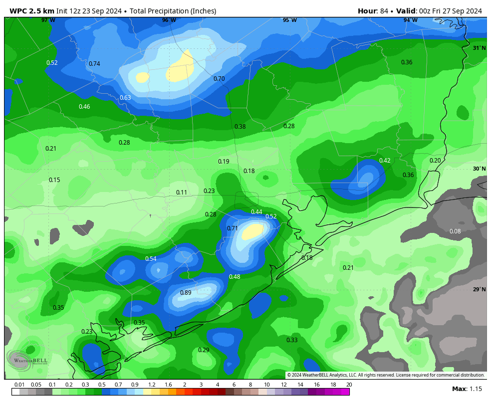
Rain accumulations won’t be great, but most of the region has a shot at some rain through Wednesday. (Weather Bell)
Monday and Tuesday
For the next two days we’re going to be stuck in the cool front waiting room. Highs for most locations should top out in the lower-90s, but some inland locations could reach the mid-90s again. Skies will be mostly sunny. What will change is that increasing atmospheric moisture levels will lead to some decent rain chances. Overall odds will be best for coastal locations, perhaps as high as 50 percent on Tuesday. The likelihood of rain will be lesser for areas further inland.
Wednesday
Some time on Wednesday we should see a line of showers, possibly broken, heralding the arrival of a front. Highs on Wednesday will likely still reach about 90 degrees, with sunny skies following the front’s arrival. Lows on Wednesday night will drop to around 70 degrees in Houston.
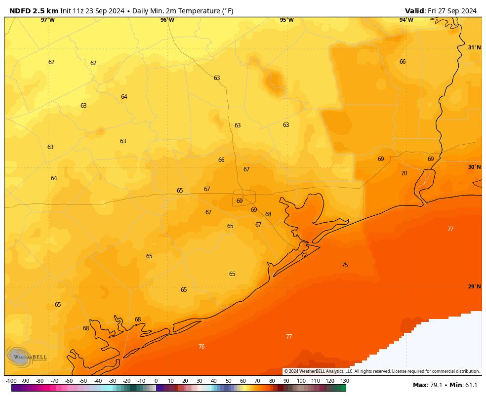
Low temperatures should reach the 60s for all locations but the coast on Friday morning. (Weather Bell)
Thursday and Friday
These will be a pair of days with high temperatures likely in the mid- to upper-80s for most locations, with sunny skies. Winds from the north will knock dewpoints into the 50s, which will mean the air feels much drier and the mornings and evenings will be quite pleasant. Low temperatures will fall into the mid- to upper-60s for most locations. This is the way of these September fronts—they tease us with fall, they never last long, but after a long summer even a modest change feels great.
Saturday and Sunday
The weekend should be warm and mostly sunny, with rising humidity. I cannot rule out some rain chances, but I’d put them at 10 percent or less, so probably not impactful. Highs will be around 90 degrees on Saturday, and perhaps a tick warmer on Sunday.
Next week
We are likely going back into the low-90s, with sunny skies, for the first half of next week. However, there is a decent amount of support for another front by next Wednesday or Thursday. Please just pencil this one in, however, as it’s still not a sure thing.
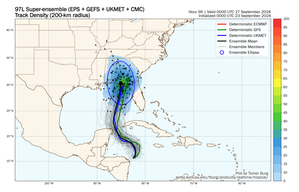
Super-ensemble forecast for the track of the Gulf tropical system. (Tomer Burg)
Tropics
A tropical system is likely to move into the Gulf of Mexico on Wednesday, and it may strike Florida by as early as Thursday evening. It poses no threat to Texas. However, I am increasingly concerned about this becoming a powerful hurricane in the very warm eastern Gulf of Mexico. We’ll have continuing coverage of its development and impacts on The Eyewall.
As for what’s next for Texas and the tropics, be sure and check Space City Weather tomorrow for an update on that.
At least three people have drowned in the nearby waters of the sports park just this year. In June, crews recovered the bodies of a 38-year-old father and his 14-year-old daughter after they failed to resurface.
(9:45 CT Monday Update): We will see PTC classified at the top of the hour. We will have a post before 11 AM CT.
(2 PM CT Update): The disturbance we are going to be tracking is now known as Invest 97L, and there will likely be a bunch of additional data available to us later today.
Headlines
Confidence is increasing in the formation of a tropical system in the southeastern Gulf of Mexico this week
Current conditions in the eastern Gulf of Mexico support the possible development of a powerful hurricane by Thursday or Friday
While confidence in a forecast track is rising, residents of the Gulf coast from southeastern Louisiana all the way to Fort Meyers, Florida should pay heed
Given the uncertainty of timing, Florida could start to see impacts in as few as four days from this system
System status
We’ve been talking about the potential for a tropical storm to form in the northwest Caribbean Sea for days, and for the time being there’s still not much to look at on satellite. We’re still seeing disorganized showers and thunderstorms in the western Caribbean Sea, in the vicinity of Nicaragua. However, what has changed is that the models we trust the most are now pointing to a more or less similar outcome over the coming week. That is, we expect a tropical system to develop, and then move into the southeastern Gulf of Mexico by around Wednesday. And after that? Well, that’s what the rest of this post will discuss.
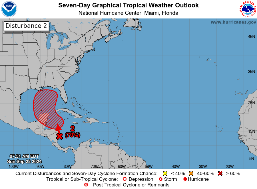
Tropical outlook for Sunday morning. (National Hurricane Center)
Track of this storm
All of our major model guidance now suggests that a tropical system will start to become better organized by Tuesday or Wednesday, with a center of low pressure forming near Cancun, Mexico, or the western tip of the island of Cuba. There is still some discrepancy in the timing and intensity, but we can have pretty high confidence in this outcome.
The timing of this does matter, as a more rapidly developing storm would likely ultimately track further to the east, which is to say toward the west coast of Florida; and a slower developing system has a better chance of going more due north, ultimately making landfall somewhere between the Louisiana delta and Florida panhandle.
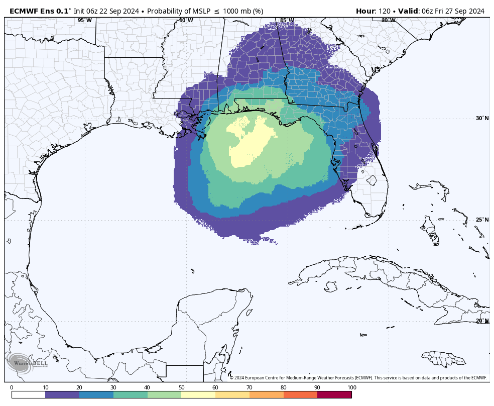
Probability of a sub-1000 mb pressure center as of 2 am ET on Friday September 27. (Weather Bell)
If we look at the 06z run of the European ensemble model above, we can get a sense of the most likely locations where the center of this storm could go. Note that this forecast indicates a potential landfall on Friday, but depending on the forward speed of this system, we cannot rule out a tropical storm or hurricane reaching the coast as early as Thursday.
The other global model ensembles are not dissimilar to the European model shown above. Our best high resolution, operational models are starting to coalesce around a landfall somewhere between Destin, Florida, and Cedar Key, Florida. However given that a center of circulation has not formed, overall confidence in where precisely this storm will go about five days from now is necessarily low.
The most important message I want to leave readers with today is that residents of the Gulf coast from southeastern Louisiana all the way to Fort Meyers, Florida, should be keeping tabs on this system over the next couple of days.
As a space guy, I’m also watching closely for impacts to NASA’s Crew-9 launch from Cape Canaveral, Florida, presently scheduled for Thursday afternoon.
What about its intensity?
Forecasting the intensity of a tropical system, of course, often more dicey than a track forecast. Because the storm has not been designated an “area of investigation,” or Invest, we do not have access to a suite of tropical-based models that are used to forecast intensity. So far the global models have been all over the place, ranging from tropical storms to a fairly powerful hurricane. However, these models typically do a poor job with intensity.
From a big picture standpoint, what concerns us here at The Eyewall is that there are no obvious things to slow this storm down. If it does start to develop a low pressure center by around Tuesday or Wednesday, then it would have two full days over the Eastern Gulf of Mexico to intensify, and if conditions are right that offers plenty of time to blow up into a powerful hurricane.
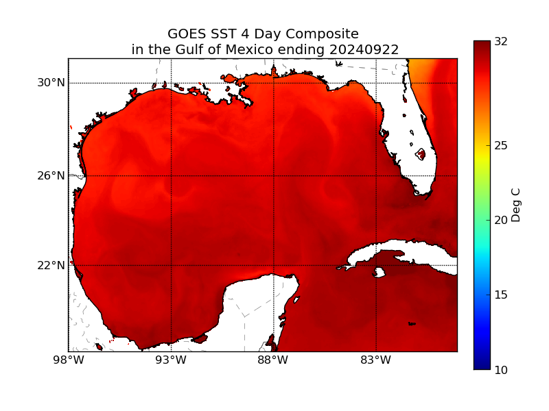
Sea surface temperatures in the Gulf of Mexico are well above the 26.5 degree Celsius threshold to form and strengthen tropical systems. (NOAA)
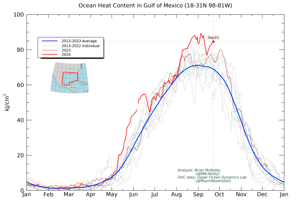
The sea surface temperatures in the vicinity of where this system should track are incredibly warm. This is partly because it is late September, and partly because of the background signal of climate change that has pushed oceanic temperatures, generally, to record highs. In addition, when we look at conditions beneath the surface, oceanic heat content is very high. This means that, as a storm churns north across the Gulf of Mexico, it will not necessarily be bringing cooler water to the surface. Deep oceanic heat is often a precursor to rapid intensification.
The oceanic heat content in the Gulf of Mexico is at record highs for this time of year. (Brian McNoldy)
Wind shear has been fairly high over the eastern Gulf of Mexico over the last several days, but this shear level is now trending lower. And if this pattern continues as expected, the environment for storm formation and strengthening should be neutral in terms of wind shear, if not even favorable. So we cannot really count on shear for assistance.
Perhaps dry air, particularly on the western flank of the storm, may play a role in inhibiting some development. However, when we stack up the extremely warm surface temperatures in the eastern Gulf of Mexico, and the shear environment, I have to believe that a hurricane is likely to form before landfall late this week. This is another reason for residents of the northern Gulf of Mexico and Florida to keep a close tab on things.
Some final thoughts
It’s still too early to say too much about impacts from this system. However, storm surge, wind damage, and inland flooding from rainfall are all on the table. Where these occur, of course, remains highly dependent upon the track.
Given the current trends, it is unlikely that we see a named storm develop before Tuesday or Wednesday. Waiting for a named storm, therefore, will not leave much time for preparation. Again, this is why we’re advising residents to keep a close eye on things over the next couple of days.
Toronto, ON – In an effort to reduce fare evasion, the Toronto Transit Commission has introduced a new initiative: personal fare inspectors for every rider. Using a Tinder-style app, every TTC rider will get to choose the Personal Fare Inspector (PFI) best suited to intimidate them into spending more money than people in almost any […]
NEW YORK—Offering football fans the chance to catch every testimony and cross-examination without having to change the channel, NFL Sunday Ticket announced this week that it is now allowing viewers to simulcast up to four domestic violence trials at the same time. “It used to be that we would only have one or two big domestic violence trials with our players, but as the league has grown, fans started to complain that there were sometimes eight different trials they wanted to watch going on at the same time,” said NFL head of marketing Tim Ellis, adding that many fans want to catch local domestic violence trials outside of their market because it looks like a good matchup or has big fantasy implications. “It used to be that you’d be watching the defense on one trial as it tried to discredit the accuser and not realize you were missing a handgun being entered into evidence over on another channel, but with our new ‘NFL Grand Jury’ package on Sunday Ticket you can keep an eye on multiple trials at once and go full screen when the action heats up. It starts at $249.99 but that gets you hundreds of different domestic violence suits to choose from during the year, including civil suits, and the package covers related gun, drug, and reckless driving trials. It’s the best way to watch all the biggest stars in the NFL.” Ellis added that while Grand Jury subscribers will have access to almost every domestic violence trial, the package will not cover NFL Thursday Trials that are licensed exclusively to Amazon Prime.
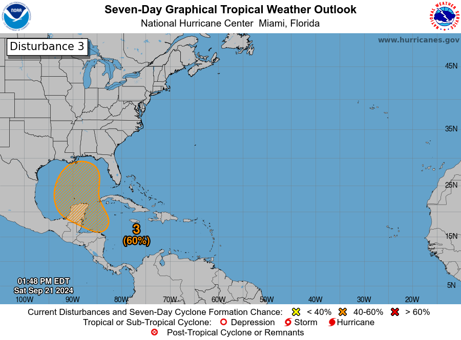
Odds of tropical development next week are increasing, likely beginning Tuesday or Wednesday.
There is a growing consensus among modeling that this system has the potential to strengthen a good bit as it comes northward and is likely to accelerate toward the central or eastern Gulf Coast late in the week.
The odds of a system getting buried in the Bay of Campeche are lessening.
The odds of an impact to Texas are lessening.
People on the Gulf Coast between Louisiana and Florida should be following forecasts closely and beginning to think about their plans for the upcoming week should they need to evacuate or hunker down.
Odds of development increasing
The National Hurricane Center continues to raise the odds of tropical development over the next seven days. We’re now up to a 60 percent risk of development.
Tropical development odds continue to inch up, with development possibly initiating around Tuesday of this upcoming week. (NOAA NHC)
Again, this is a rather conservative view of things, and I anticipate we’ll see this continue to inch up today and tomorrow and push into the “2 day” development map tomorrow or Monday. Modeling is beginning to coalesce around the idea of development north of Honduras or just east of Belize, or on the Caribbean side of the Yucatan. The general theme of the models since yesterday has been to align more with the faster, stronger solutions which would be apt to bring a storm north or north-northeast across the Gulf of Mexico and toward the coast between Louisiana and Florida. There is still a good deal of uncertainty on specifics here, including whether or not it develops. There is still a minority of ensemble members in modeling that struggle to get this going. Not likely to happen, but it’s a non-zero possibility. I just want to highlight that there are reasons this isn’t a 100 percent chance of development right now.
A potential threat to the U.S. Gulf Coast
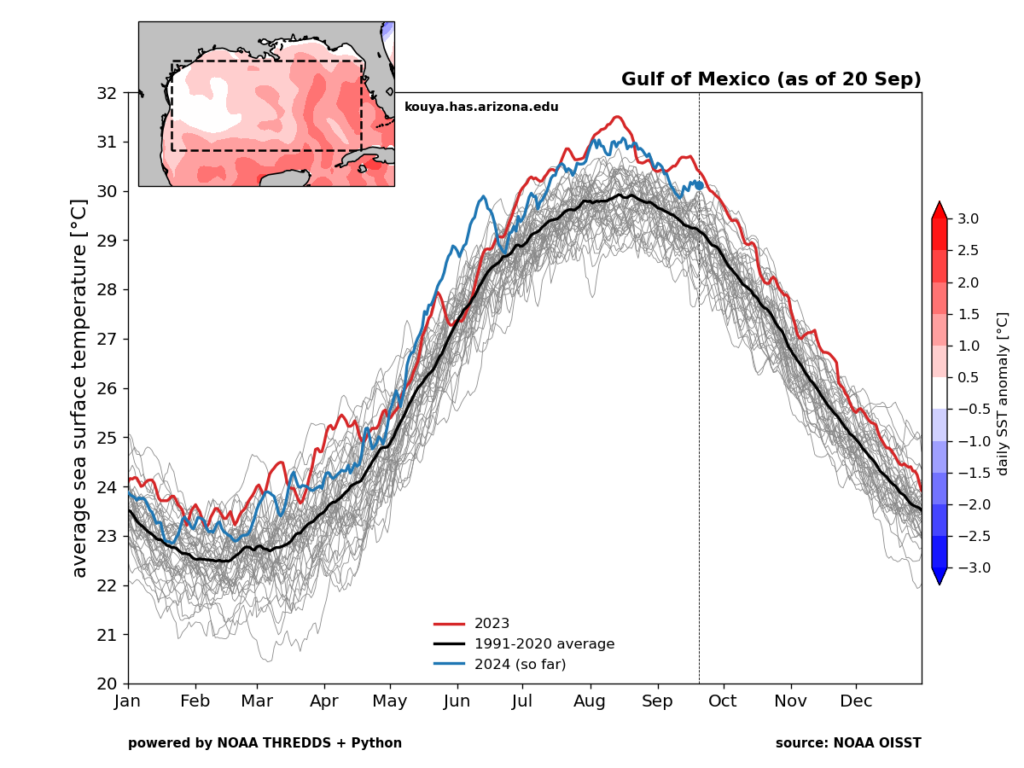
All that said, I just want to make clear right now that this has the potential to be a strengthening storm in the Gulf, moving north, fairly fast later this coming week. When Francine moved into Louisiana it passed over warm but not super warm waters in the central and western Gulf of Mexico. If this upcoming system tracks farther east of Francine as seems likely, it will be passing over much warmer Gulf waters.
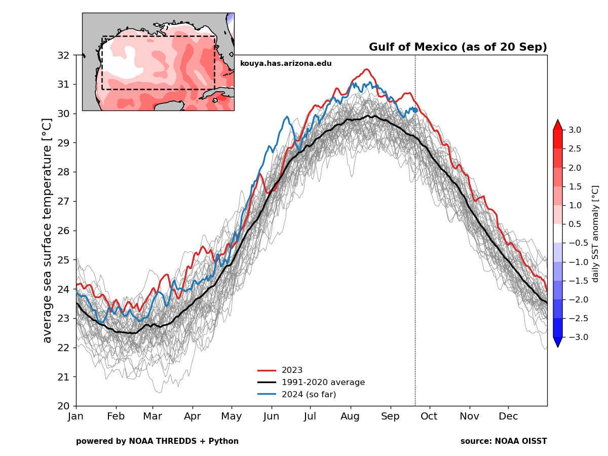
The Gulf of Mexico as a whole is just shy of record warm levels, and most of that is being driven by the waters in the eastern Gulf. (University of Arizona)
The near-record warmth of the Gulf is being driven almost entirely by the eastern half of the Gulf of Mexico, close to where this system will likely pass.
I don’t want to overstate the risk at this point, but given the scenario (Quick moving, very warm water, generally favorable upper level conditions, and less dry air than Francine contended with), there is some legitimate risk of a significant storm on the central or eastern Gulf Coast late next week. You should be following this forecast closely if you live between Florida and Louisiana, and you should be ready to put your hurricane plans into motion quickly this week once we see further agreement on possibilities.
So what do the models say?
We have seen the operational models reduce the spread between each other considerably in the last 24 hours. We still have some variability on track and timing, but there has been a tendency to push toward a track northward between Louisiana and Florida sometime between Thursday and Sunday next weekend. The odds of the system getting buried off the Yucatan in the Bay of Campeche has dropped off some since yesterday.
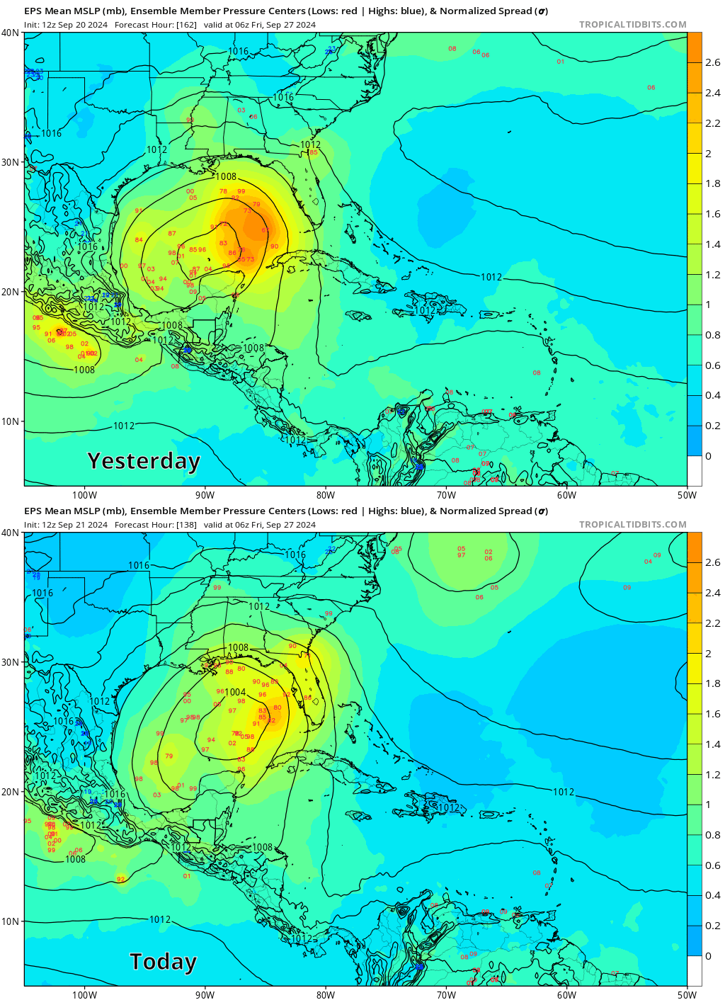
Today’s European ensemble at 12z, hot off the presses still shows a very wide spread of possibilities, from a system getting buried in the Bay of Campeche to one tracking southeast into South Florida. But what I pay attention to with these runs is what has changed or where the “clustering” is occurring. If we compare the same image at the same time 24 hours ago, we can see a shift in both the ensemble mean (solid black lines) to the northeast and a decline in the number of Euro ensemble members that bury this system in the Bay of Campeche.
A comparison of yesterday’s Euro ensemble mean and individual member forecasts for next Thursday evening versus the same view today shows a marked shift to the northeast with the mean and fewer members in the Bay of Campeche, an indication that trends are shifting north and east in the Euro, closer to what the GFS suite has been showing. (Tropical Tidbits) (Editor’s note: This image was adjusted at 4:45 PM CT Saturday to align the forecast times which were previously askew by 6 hours)
This further indicates that there is a definite trend toward a faster and more progressive storm to the north or northeast within the modeling. We can see further evidence of this in a consistent GFS, the ICON, and the Euro AI model (AIFS) showing similar type of outcomes now.
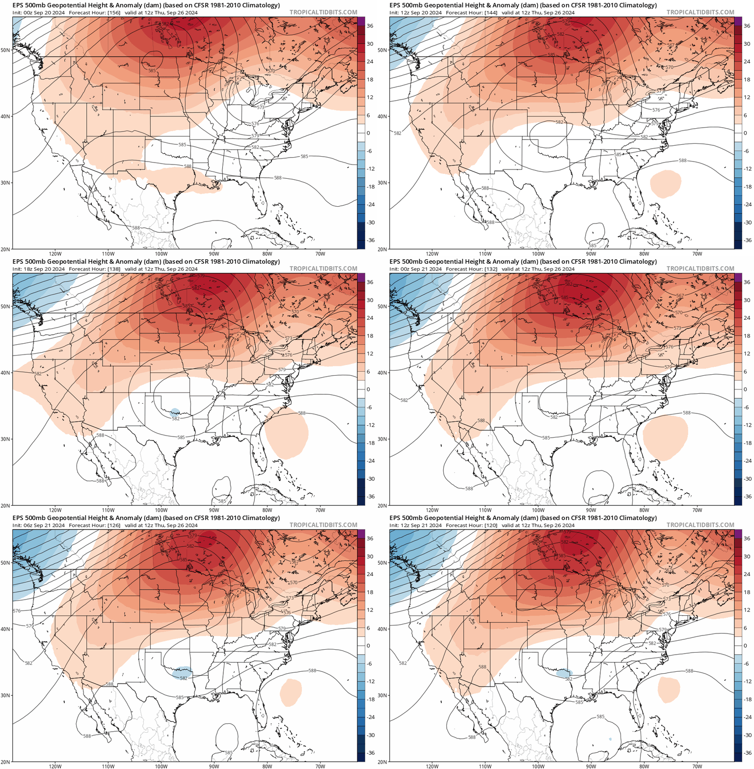
Why is this? Since yesterday, we have seen a bit of a signal in modeling for a cutoff low or secondary trough to develop over Arkansas or Oklahoma. This is something of a new wrinkle.
The last 6 runs of the Euro ensemble mean showing a developing and farther east trough or cutoff low over Arkansas that is likely helping to “pull” the tropical system straight north. (Tropical Tidbits)
Whatever the case, this slightly stronger and farther east trough is helping to “pull” at the tropical system in the Gulf and force it to the north. This is what is likely shifting the Euro ensemble to the side of the GFS and other modeling now and why we’re seeing some additional agreement develop on a threat to the central or eastern Gulf Coast.
The bottom line: There is building agreement in the modeling that a tropical system is going to come north late this coming week toward the central or eastern U.S. Gulf Coast. While details remain elusive there is enough evidence of a threat to that region that folks should be paying close attention to forecasts and thinking about their plan for later this week should they need to evacuate or hunker down. We’ll have more on this tomorrow.