Shared posts

16 Feb 08:33

2 million Texas households without power as massive winter storm drives demand for electricity

by Matthew Watkins
A northbound view of I-35 at East Stassney Lane in south Austin on Feb. 15, 2021.
Interstate 35 near Stassney Lane in Austin was blanketed with snow on the morning of Feb. 15. A major winter storm affected the entire state of Texas. Credit: Miguel Gutierrez Jr./The Texas Tribune

We’re no longer updating this live. For the latest updates, click here. Sign up for The Brief, our daily newsletter that keeps readers up to speed on the most essential Texas news.

Here's what you need to know:

  • 2 million Texas households are without power
  • Dallas urges residents to reduce their electricity usage
  • Houston mayor seeks answers on how outages were handled
  • Texas cities open emergency shelters
  • 100,000 Fort Worth residents receive boil water notice
  • State sending extra resources to help across Texas

The state’s electric grid operator lost control of the power supply Monday morning as 2 million Texas households didn't have heat or other electric appliances working at home while a massive winter storm delivered freezing temperatures across the state.

When the state’s grid operator, the Electric Reliability Council of Texas, began implementing rolling blackouts at 1:25 a.m. Monday, the outages were intended to be implemented on a rolling basis — up to 45 minutes per affected area, according to the ERCOT.

Instead, some Texans in Austin, Houston and other cities were without power into Monday afternoon and all morning since even before ERCOT called for the rolling blackouts. And some companies that deliver electricity to households and businesses have told customers to expect to be without power through at least the end of the day as they work to restore power generating units that went offline during the storm.

“Unfortunately, if you are a customer who is currently experiencing an outage, you should be prepared to be without power for at least the rest of the day,” tweeted CenterPoint Energy. Houston Mayor Sylvester Turner said midday Monday that more than 1.1 million CenterPoint customers were without power.

Jackie Sargent, the general manager for Austin Energy, said Monday afternoon that based on information from ERCOT, the local power outages could extend into Tuesday afternoon.

“We are aware of where our system is at, and we are operating with the constraints and the direction of ERCOT,” she said. “ERCOT has said that based on what they are looking at that, this situation is likely to continue through the night and possibly into the afternoon tomorrow. So it depends on what we do as consumers in managing our load, our consumption of electricity.”

The electricity grid was designed to be in high demand during the summer, when Texans crank their air conditioning at home. But some of the energy sources that power the grid during the summer are offline during the winter. So when Texans stayed home during the storm on Sunday and demanded record amounts of electricity, the state’s energy system could not keep up.

Some of the energy sources powering the grid were knocked out by the inclement weather, most of which were facilities run by gas, coal or nuclear energy.

“Most of the plants that went offline during evening and morning today were fueled by one of those sources,” said Dan Woodfin, senior director of system operations at ERCOT.

Wind turbines, which provide a much smaller source of energy for the state’s power grid, were iced over and also out of commission.

The storm that hit Texas is rare for both its scope and its intensity. On Sunday, the National Weather Service issued a winter storm warning for all 254 counties. Cities like Dallas and Austin had temperatures in the single digits Monday morning. Close to the coast in places like Houston and Corpus Christi, the weather was in the teens.

ERCOT announced Sunday night that it had set a winter record for power demand, reaching 69,150 megawatts between 6 and 7 p.m. ERCOT said Monday morning that 30,000 megawatts of power generation had been forced off the system. The grid operator also said it would provide an update at 10:30 a.m. Central time Monday.

The storm has shut down much of the state. Numerous roads are iced over, many schools have closed and, at Gov. Greg Abbott’s request, President Joe Biden declared a federal emergency declaration across the state. Despite Abbott's request, Turner, the Houston mayor, said the state needs to take responsibility for what happened.

“The state must own and explain the magnitude of these power outages across the State,” Turner tweeted Monday.

Abbott didn't publicly address the widespread outages until 1:29 p.m., more than 12 hours after hundreds of thousands of Texans began losing power.

“Many power generation companies' facilities froze overnight and shut down their ability to generate power,” Abbott tweeted. “They are working to get power back on line.”

Mitchell Ferman and Sami Sparber

“This is a very serious emergency”

In Dallas, County Judge Clay Jenkins declared a state of emergency and asked nonessential businesses to delay their opening or start times until 10 a.m. Tuesday. The order also asks manufacturing and industrial businesses that “use electricity in their operation or processes” to close on Tuesday.

Jenkins also strongly urged residents to set their thermostats to no more than 68 degrees Fahrenheit.

“This is a very serious emergency,” Jenkins said during a Monday night press conference. “My full focus is on this emergency and yours should be too.”

A spokesperson for the power company Oncor said most of the power outages in Dallas-Fort Worth have been due to excess demand. “That increased demand and that load has resulted in some of our transformers having equipment failures just because they’re having to run like it’s a 100-plus degree summer day,” the spokesperson, Kerri Dunn, said.

Dunn did not say when Dallas-area residents would get their power back, noting the overnight winter weather might complicate efforts. — Elvia Limón

Houston mayor seeks answers on how outages were handled

In Houston, Mayor Sylvester Turner said that while the situation with this weekend’s winter storm was unprecedented, it should spark a debate on Texas’ electric resiliency.

“When this is all over, we will need to have a conversation — a serious conversation — about why we are where we are today,” Turner said Monday at a news conference. “These are not rolling blackouts. These are power outages at a huge unprecedented scale.”

According to CenterPoint Energy, around 1.2 million users in the Houston area are without power. Turner also said that the number of outages could increase as temperatures go down in the evening and that they could last even until tomorrow. By Monday afternoon, that number had gone down to 1 million.

On Monday afternoon, Harris County Judge Lina Hidalgo said about 70,000 of the outages in the area were because of weather damage and that CenterPoint was working to restore power to those homes.

“The bottom line is that neither CenterPoint nor I can give you an estimate on when the power will come back on,” she said. “As much as we wish it wasn’t so, things will likely get worse until they get better.”

Hidalgo also said a Harris County Health Department, where 8,400 of Moderna vaccines were being stored, had a power outage around 2 a.m. Monday and its background generator failed. County officials were able to distribute 5,410 of vaccines to several area hospitals, the county jail and Rice University before they could spoil, she said. The rest of the vaccines were stored again after receiving guidance from Moderna representatives, Hidalgo said. — Elvia Limón

Texas cities open emergency shelters

Several cities across the state have opened emergency shelters for residents without homes. In Dallas, the Kay Bailey Hutchison Convention Center opened on Friday to 300 people and will remain open as long as temperatures are below freezing, reports NBC DFW.

On Monday, Fort Worth Mayor Betsy Price said residents could call 817-392-1234 to be directed to one of the city’s warming centers. Residents can also find transportation help by calling that number.

The George R. Brown Convention Center and Lakewood Church in Houston opened as warming centers Sunday. Houston set up 500 beds inside the convention center and allowed pets. But on Sunday night, Houston Mayor Sylvester Turner said in a tweet that the center was nearing capacity. Turner said residents who need access to a warming center should call 311 or 211 to be directed to one of the several shelters in the city.

In Austin, a warming center opened on Saturday at Palmer Events Center. Austin officials said single adults in need of shelter should report to the Central Library and that families should go to the Downtown Salvation Army Shelter, reports KVUE. Several community organizations in San Antonio are stepping up to help unsheltered residents with a place to stay, food or supplies to keep warm. — Elvia Limón

100,000 Fort Worth residents receive boil water notice

Around 100,000 of Fort Worth residents are under a boil water order after a water treatment plant experiencing multiple power outages on Monday, reports WFAA. The Eagle Mountain Water Plant and raw water pump station has been without power for more than two hours. The boil order is expected to last until at least midday Wednesday. Even after water service returns, officials will need 24 hours to test the water.

Meanwhile, the city of Kyle in Central Texas is asking residents to stop all water use until further notice. According to the city’s Twitter account, Kyle is close to “running out of water supply” after power outages at the Guadalupe-Blanco River Authority and locally. — Elvia Limón

State sending extra resources to help across Texas

As Texans across the state grapple with a lack of power amid freezing temperatures, Gov. Greg Abbott on Monday said that he and the Texas Military Department have deployed National Guard troops across the state to help take people to one of the 135 local warming centers set up across Texas.

Other state agencies are also deploying resources and personnel to help local officials clear roadways and assist essential workers, including health care professionals and power grid workers.

Among the resource deployments Abbott announced:

  • 3,300 troopers and 3,300 patrol vehicles from the Texas Department of Public Safety
  • 90 personnel members and 28 high-mobility vehicles from the Texas Military Department
  • 585 personnel members, 531 4x4 vehicles, one aircraft and nine K9 teams from Texas Parks and Wildlife
  • 2,314 personnel, 695 snowplows and 757 4x4 vehicles from the Texas Department of Transportation.

Drivers urged to stay home as road crews plan work

State transportation officials are urging Texas drivers to stay home as crews work to clear snow and ice from roads.

Low temperatures and snow accumulation resulted in freezing on roadway surfaces across the state, a spokesperson for the Texas Department of Transportation said in an email Monday afternoon.

“TxDOT crews have been treating roads across the state since early last week, and now we are plowing snow and once snow is removed, we can start to spot treat again,” Ryan LaFontaine said. “This weather event is expected to continue so we urge drivers to stay home and exercise patience as we try to clear roadways safely.” — Sami Sparber

Here's how to help:

  • Dallas: Dallas Homeless Alliance President and CEO Carl Falconer said donations can be made to Our Calling, who is managing the city’s shelter at the convention center.
  • Austin: Chris Davis, communications manager for Austin’s Ending Community Homelessness Coalition, or ECHO, said people can find a list of ways to help here. These donations range from sleeping bags to monetary donations for hygiene and snack kits.
  • San Antonio: South Alamo Regional Alliance for the Homeless Executive Director Katie Vela said their biggest area of need is volunteers to work the overnight shifts, especially those living in the downtown area who might be able to walk to the shelters. Vela also said the shelters are also in need of hot meals beginning Tuesday. People can find the list of shelters here.
  • Houston: Catherine B. Villarreal, the director of communications for the Coalition for the Homeless, said people can donate to any of the organizations in The Way Home listed here.

Matthew Watkins, Julián Aguilar and Ayan Mittra contributed to this report.

Disclosure: CenterPoint Energy, Oncor and Rice University have been financial supporters of The Texas Tribune, a nonprofit, nonpartisan news organization that is funded in part by donations from members, foundations and corporate sponsors. Financial supporters play no role in the Tribune's journalism. Find a complete list of them here.


16 Feb 03:25

Widespread power outages on Houston’s coldest day in decades

by Eric Berger

Like many of you, my home in League City has been without power since about 2 a.m. this morning. The power went out just as the winds came up and temperatures really began to plunge across the Houston area.

Before the winter storm impacted the region, officials with the Electric Reliability Council of Texas (ERCOT) said there would need to be rolling blackouts that would last 15 to 45 minutes. However, what is happening across much of the Houston area is more significant than that, or power lines affected by ice.

“These are not rolling blackouts. We are dealing with systemwide power outages across the state,” Houston Mayor Sylvester Turner tweeted shortly after 8 a.m. on Monday morning.

ERCOT is responsible for managing the flow of power across the state. Companies such as CenterPoint are responsible for maintaining the “lines and poles” that deliver electricity to your home. That CenterPoint’s website is experiencing technical problems this morning is not helping to clarify the situation.

One local public official told me that ERCOT has had to take several power generating plants offline, presumably due to the extremely cold weather. This is unfortunate, given that these conditions have been forecast to occur for almost a week now.

I don’t have confidence in any time frame for when power might be restored to the metro Houston area. It’s really outside my area of expertise. But this is a bad situation when Houston is seeing high temperatures around 20 degrees today, and will be much colder tonight, and we can’t be certain when the heat will come back on.

We’ll have a weather update by around 1 p.m. this afternoon.


16 Feb 03:18

Valentine’s Day Special

by Mary Kelly

valentines

Dating, love, and romance are always available at your local library. We here at ALB want to make sure you are taking advantage of so many titles geared to help you manage your love life! (You’re welcome!) Our first post listed, Make your own sex toys has been gracing our Valentine’s list off and on since 2012. To this day, I still get a bit squeamish when I see people squeezing the vegetables and fruit at the grocery store.

Happy Valentine’s Day!

Mary and Holly

Make Your Own Sex Toys (NSFW)

DIY sex toys cover

How to Marry the Man of Your Choice

how to marry the man of your choice book

How to pick a mate

how to pick a mate

How to Catch a Man

how to catch a man

The Shy Guy’s Guide to Dating

shy guy dating cover

The post Valentine’s Day Special appeared first on Awful Library Books.

16 Feb 03:17

My Valentine

by Cassandra Calin

Happy Valentine’s Day, from me to you!

16 Feb 03:17

Guess Who Violated the U.S. Constitution?

by Gabriel Thibodeau
16 Feb 03:14

Saturday Morning Breakfast Cereal - Error

by tech@thehiveworks.com


Click here to go see the bonus panel!

Hovertext:
Remember bars? Remember? You wait say Barman- fetch me a beverage so that I have not got to make it myself, and they would actually do it for you!


Today's News:
15 Feb 23:16

mRNA Vaccine

To ensure lasting immunity, doctors recommend destroying a second Death Star some time after the first.
15 Feb 23:12

Dogtor

by Reza
15 Feb 15:03

VALENTINES DAY AT THE MALL!

by noreply@blogger.com (JerryMaguire)
15 Feb 15:00

Saturday Morning Breakfast Cereal - Food choice

by tech@thehiveworks.com


Click here to go see the bonus panel!

Hovertext:
Algorithms to Live By had a good argument that got me to do this a lot less. Basically, saying you don't know is forcing the other person to use my brainpower, so what appears kind is actually foisting work on others.


Today's News:
15 Feb 14:58

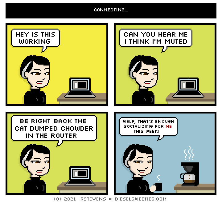
Connecting...

this is a diesel sweeties comic strip

CAN YOU HEAR ME I THINK I’M MUTED

14 Feb 14:09

How Machine Language Works

by The 8-Bit Guy
14 Feb 13:25

Comic for 2021.02.14

New Cyanide and Happiness Comic
14 Feb 02:13

A LIMITED-TIME OFFER YOU CAN'T REFUSE!

by noreply@blogger.com (WrongMan)
14 Feb 02:12

HOW TO SEARCH THE WEB!

by noreply@blogger.com (WrongMan)
14 Feb 02:11

GOBBLE GUYZ!

by noreply@blogger.com (WrongMan)
Edit by Kyle Freakin' Kenyon!
14 Feb 02:07

Saturday Morning Breakfast Cereal - Second Strike

by tech@thehiveworks.com


Click here to go see the bonus panel!

Hovertext:
The yinzers will be the first up against the wall.


Today's News:
13 Feb 23:28

Here’s the latest on Houston’s winter storm and exceptional cold

by Eric Berger

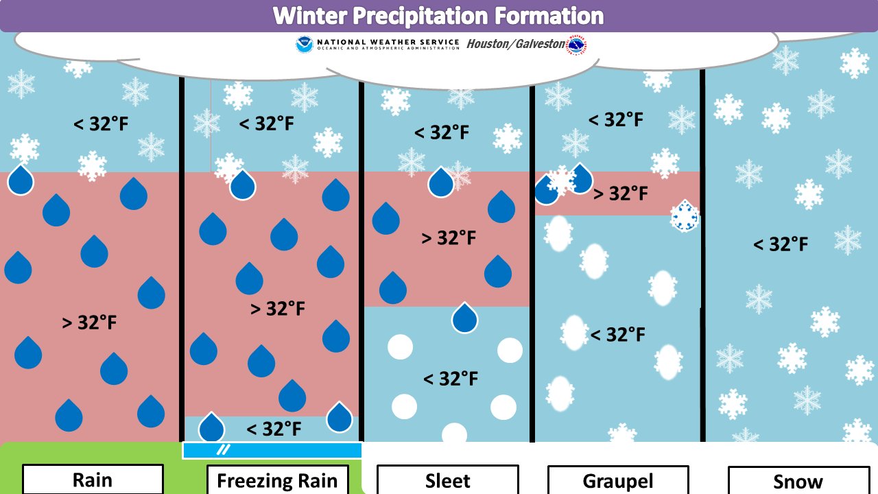
Good morning. Before jumping in to the forecast, I wanted to spend just a moment discussing why some areas of the region will see snow on Sunday night and Monday, and others sleet or freezing rain. It has to do with the temperature in the column of air above the surface, through which precipitation falls.

Snowflakes form high in the atmosphere, and if the temperature remains below 32 degrees as they fall thousands of feet to the surface, they remain snow. However, if there are pockets of warmer air and then sub-freezing temperatures again, sleet will form as snowflakes, melt, and then re-freeze as small ice pellets. And finally, if there is warmer air near the surface, but not at the surface, we’ll get freezing rain. The graphic below helps depict these processes.

How different types of winter precipitation form. (National Weather Service)

This is the primary reason we think freezing rain is most likely near the coast—where the Arctic air mass will be most modified by the warmer Gulf of Mexico near the surface—and snow most likely over areas well inland. In terms of roads and potentially power lines, freezing rain is most problematic because it only takes a little to stick to roads and make them icy, and not that much more to accrue on power lines and weigh them down, or become more susceptible to blowing winds.

We’re starting to get closer to Monday, so higher resolution models are beginning to come into our forecasts, and as they do so confidence in which types of winter precipitation, and how much will fall, will increase.

Saturday

Temperatures are above freezing across the Houston area this morning, but only barely. They won’t rise a whole lot today, likely only reaching the upper 30s in Houston, and near 40 degrees along the coast. Buy hey, that’s better than freezing, right? In terms of wintry precipitation, our concerns now begin tonight for parts of the metro area northwest of a line from Katy to Tomball to Conroe. This is because lows for those areas are now expected to fall to about 30 degrees. This, in concert with light precipitation, could lead to some icing on elevated roads and bridges.

Sunday

Highs on Sunday should get into the mid-30s for even these inland areas, and warmer in Houston itself, so traveling across the metro area after mid-morning on Sunday should be fine. But the further west and north you go, you’re still going to run into freezing conditions.

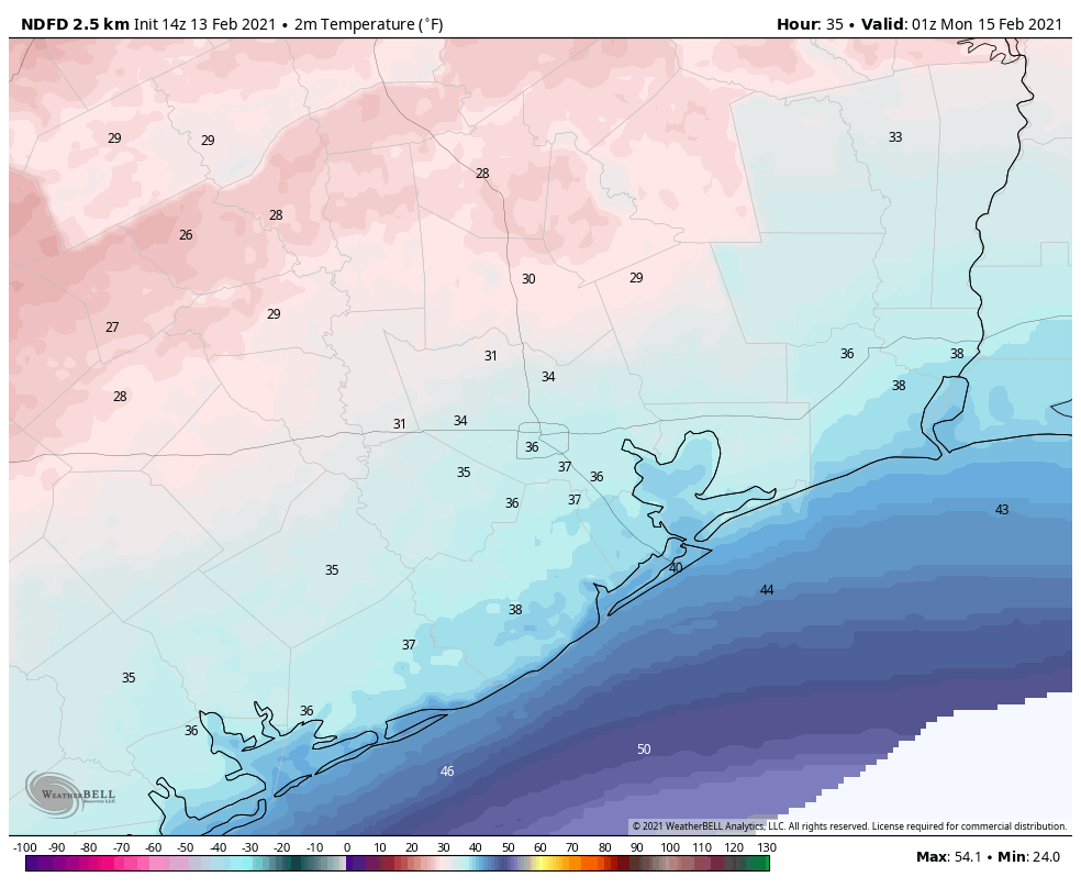
Conditions begin to deteriorate by around sunset on Sunday in Houston. This is when we expect widespread precipitation to move into the area, and temperatures to begin to fall below 32 degrees. Some inland areas won’t see above freezing temperatures again until Wednesday.

Freezing temperatures begin to reach northern and western Houston by sunset on Sunday. (Weather Bell)

Sunday night and Monday

This is when conditions on area roadways will become treacherous. As noted above, we expect snow to fall across inland areas where temperatures are the coldest, but we don’t know where snow will switch to sleet, only that this line will likely be somewhat north of Interstate 10. In terms of accumulations, here is our best forecast at this time, but it remains highly subject to change as additional high-resolution forecast models enter the picture.

Snowfall: For areas that receive it, about 1 inch, with 2 or more inches possible for Conroe and areas north of there.

Sleet: About 1 inch for central parts of the Houston metro area, with less north (where there will be more snow) and south (where freezing rain is more likely).

Freezing rain: About one-quarter inch for areas along and south of Interstate 10.

It now appears likely that precipitation will wrap up by around Noon on Monday, if not shortly before. Unfortunately, because temperatures at that time will probably only be in the low 20s for most of the area, whatever falls on the roads is not going anywhere. Moreover, with winds gusting out of the north above 30 mph, especially along the coast, it will feel like 10 degrees or below. Finally, these winds could play havoc with iced over power lines. So yeah, Monday is a day to stay home and hunker down.

Tuesday

After the precipitation ends, skies may begin to clear overnight. With extremely cold air in place, this will allow for ideal cooling conditions heading into Tuesday morning. And it will be exceptionally cold for Houston. Areas where there is snow on the ground, well west and north of Houston, may see temperatures of 5 to 10 degrees, and the coast will only be marginally warmer, in the low 20s. (The all-time record low for Houston is 5 degrees, set in 1930.)

Forecast temperatures for 6am CT Tuesday. (Weather Bell)

Temperatures should reach above freezing, if barely, for areas south of Interstate 10 on Tuesday. But areas north of that line may continue to see freezing temperatures throughout Tuesday and Tuesday night. Lows will not fall much Tuesday night.

What this all means for roadways in the Houston for Tuesday morning and beyond is unclear. It will depend on how much precipitation falls Monday, in what form, and whether efforts to de-ice roadways are effective. I can offer no good predictions here, sorry.

Wednesday, Thursday, and Friday

Unfortunately, another round of precipitation is likely on Wednesday, as moisture moves inland from the Gulf of Mexico, and another front approaches. This will fall as rain on Wednesday, but for inland areas at least it could turn into sleet or freezing rain on Wednesday night—at least for areas along and north of Interstate 10.

The details of this are still very much in flux, but there’s a chance for more icy roads on Wednesday night and Thursday morning. At this time we do anticipate less impact than we’re likely to experience on Monday. Lows drop into the 20s on Thursday night, probably, before finally warming well above freezing on Friday.

And that’s the end. Saturday should get into the 50s or so, and by Sunday we’re back to highs in the 60s. Until then, it’s going to be absolutely frigid. Stay safe, y’all.

Matt will have a brief update on the forecast later today, and also take a first stab at historical significance of this kind of winter event for Houston.


13 Feb 12:33

Saturday Morning Breakfast Cereal - Bastardry

by tech@thehiveworks.com


Click here to go see the bonus panel!

Hovertext:
You can hear all of my opinions on why social media is a blight on society 4 times an hour on twitter.com


Today's News:
13 Feb 12:32

Normal Conversation

"I think I'll pass. These days I have a hard time feeling comfortable in crowded bars with loud music and lots of shouting." --me, after the pandemic, but now for a second reason
12 Feb 23:05

U.S. Gov Warning on Water Supply Hack: Get Rid of Windows 7

by Ryan Naraine

On the heels of last week’s lye-poisoning attack against a small water plant in Florida, the U.S. government’s cybersecurity agency is pleading with critical infrastructure defenders to rip-and-replace Windows 7 from their networks as a matter of urgency.

read more

12 Feb 21:51

Dr. Mountainson’s Folly

by Reza
12 Feb 16:50

A major winter storm followed by brutal cold will impact the region on Monday & Tuesday

by Matt Lanza

Bonafide winter has arrived in Texas, and we’re just getting started. This may be Texas’s most severe and damaging cold snap since the 1980s, and it’s going to come with a significant mess on Monday, so do read on.

Today

After yesterday’s fireworks via quite a few thunderstorms in the area, we expect today to be a bit quieter. There should still be some showers, and there may be some drizzle as well. But we aren’t expecting much more than a few hundredths to tenths of an inch of rain today, and some areas will stay completely dry. The best coverage of showers should be south and east of the city. With plenty of clouds, temperatures won’t go far today. Look for highs maybe getting to 40 degrees or so, low-40s if you’re lucky.

Note to those traveling north or west of Houston, as we get a lot of questions: There may be some patchy freezing drizzle well off to our north, especially this morning. So if you’re headed to Austin, Waco, or Dallas, be hyperaware of road conditions. Bookmark drivetexas.org for updates for the state and the Houston TranStar site for additional local conditions.

Saturday & Saturday night

Tomorrow will likely be a similar sort of day to today. Expect clouds, some showers, some light rain or drizzle, and cold temperatures struggling to get to 40 degrees or so. There could be a slightly more vigorous disturbance that pivots through very late in the day Saturday or Saturday night and brings more numerous showers. If that happens, there is the chance that areas north of I-10 get close to the freezing mark and freezing rain (ice) could become an issue.

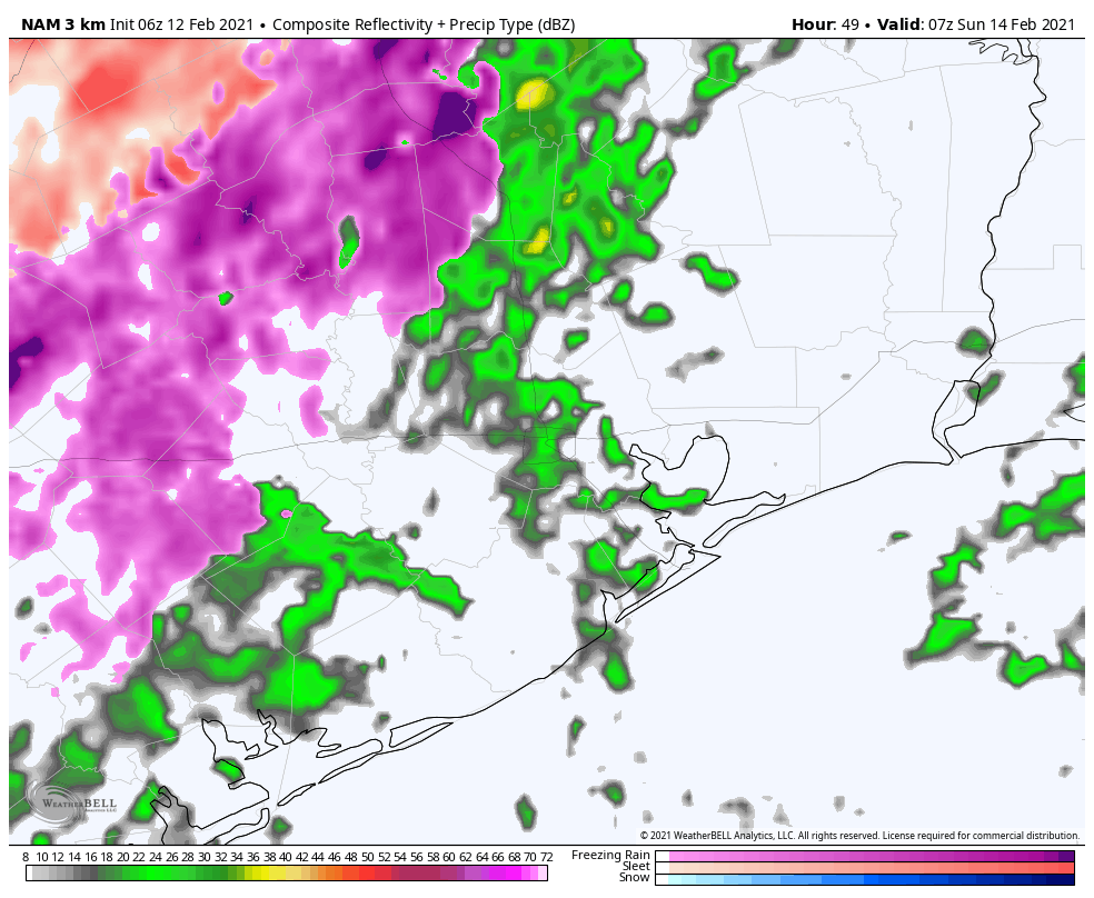
Forecast radar from the NAM model for 1 AM Sunday morning, showing rain in the Houston area (green) and freezing rain or drizzle north and west of Houston (pink). Just one model’s depiction, so we’ll need to watch this period closely. (Weather Bell)

This would likely be mainly focused on the nighttime hours. The Houston area should just see a cold rain, but if you have to make your way north of Houston for any reason after 6 PM Saturday, you will want to pay particularly close attention to any forecast updates this weekend. Lows bottom out in the low- to mid-30s.

Sunday

That Saturday night disturbance should exit stage right on Sunday morning, and the majority of Sunday looks dry but cloudy. Because of the generally drier conditions, we may be able to sneak into the low or even mid-40s on Sunday afternoon.

Sunday night through Monday afternoon

So, here’s where the troubling part of our forecast begins to emerge. As we’ve been discussing for days now, a strong disturbance and storm system are going to pass through the region on Monday morning. We are growing highly confident in wintry precipitation impacting almost the entire region, including the coast on Monday now. There is a good chance that travel may become close to impossible anywhere in the Houston area beginning early Monday morning.

Here’s what we know right now:

  • Rain, or a wintry mix will develop on Sunday night.
  • It will likely quickly transition to all freezing rain and/or sleet, except maybe at the immediate coast before sunrise Monday.
  • Precip may be heavy at times Monday morning.
  • Frozen precip will likely end as some sleet or snow flurries by early Monday afternoon.
  • Ice and/or sleet accumulation is likely across much of the area.
  • Temperatures will likely remain below freezing all day Monday, dropping into the lower 20s by afternoon.
  • Winds will gust to 20-25 mph most of the day Monday.

Now, for what we really don’t know:

  • Whether sleet or freezing rain will be the dominant precipitation type (snow seems mostly unlikely except well north and west of Houston or at the very end of the event).
  • How much sleet and/or freezing rain falls.
  • If there will be snow accumulation at the end.
  • The exact timing of the storm. (still some 3+ hour differences among various weather models)
  • How many power outages will occur.

Those first two points are very important, as there is a monumental difference in impacts between an all-sleet storm, an all-ice storm, and an ice storm followed by sleet. A couple inches of sleet is a nuisance, but it’s not severely problematic. A tenth to quarter-inch of ice with gusty winds and bitter cold could be extremely problematic. And a layer of ice caked over by sleet or wet snow is even more problematic. Unfortunately, we really aren’t good enough to predict winter storm precipitation totals to that specificity this far in advance. I can tell you that having looked at model data, they are loudly implying that a large portion of the area will be at risk for icing on Monday. This event will likely be problematic.

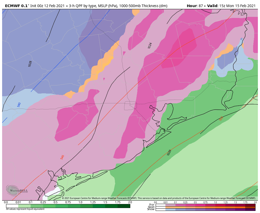
Forecast precipitation types from the ECMWF (European) model on Monday morning. Freezing rain (pink) would extend from the Houston metro to about the coast, with sleet (orange) and snow (blue) off to the northwest of Houston. This is, again, just one model’s depiction of the weather, however other models we use aren’t terribly different. (Weather Bell)

Much like flooding events, models struggle mightily when it comes to exact placement of the bullseye of a winter storm. But even putting that aside, any amount of ice on the roads here will make travel close to impossible, and that seems to be the direction we are heading for Monday.

So to summarize: A winter storm will impact the majority of the region late Sunday night through Monday afternoon with a sleet or ice storm being the most plausible outcome right now. We would strongly encourage folks to prepare to remain wherever you are from Sunday night through Tuesday morning. This forecast will change between now and then, and Eric and I plan to keep you posted all weekend long.

Monday night & Tuesday

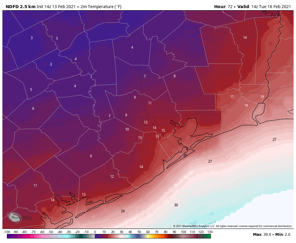
The temperatures will be the big story once our storm exits Monday afternoon. We will likely see highs on Monday near freezing very early, dropping into the low-20s by afternoon. Those temperatures will continue steadily downward Monday night. The current forecast from the National Weather Service for Tuesday morning is shown below.

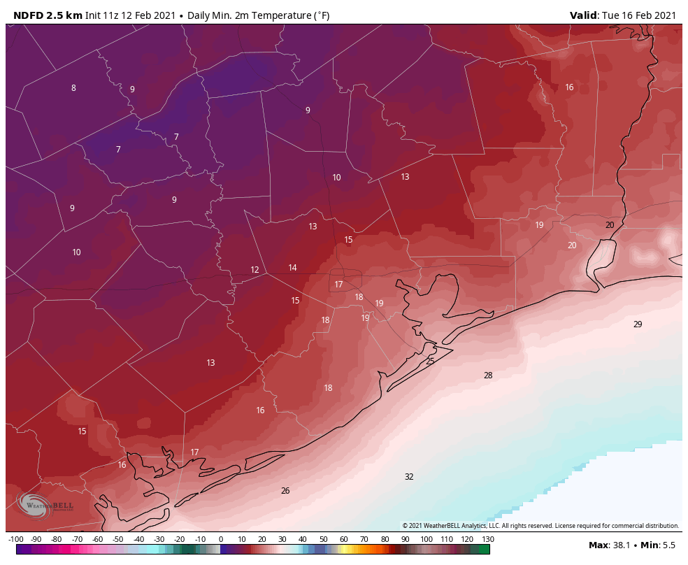
Forecast low temperatures for Tuesday morning. We likely haven’t seen a map like this since December 1989. (NWS via Weather Bell)

Yeah, that’s cold. We are expecting the city of Houston to bottom out at 15 to 20 degrees. The western and northern suburbs will likely fall to 10 to 15 degrees. Bay Area and coastal locations will be around 20 degrees, give or take. If we were to somehow see accumulating snow on Monday, you could probably subtract another 1 to 3 degrees from these values at least. The last time Houston officially hit 15 degrees? December 1989.

Tuesday will see sunshine at least! We should break out above freezing by late morning. The combination of the sun and temps in the mid-30s should allow us to melt most of Monday’s ice. We hope.

It’s worth noting that this won’t be just an extreme cold event in terms of temperature. It will also be so in terms of duration. Temperatures will likely drop below freezing in Houston on Monday before sunrise and not make it above freezing til mid or late Tuesday morning. This will easily be a 24 to 36 hour stretch of subfreezing temperatures for Houston, with a longer-duration north of the city. It has been over 30 years since Houston has seen this kind of cold weather. You absolutely need to prepare your home for the impacts. Reliant has provided some very useful advice below. You can also read more cold weather prep tips here, here, or here.
Later next week

I’ll be honest with you: I don’t even want to think about later next week right now, but the reality is, more headaches are likely. Another storm system is likely to impact the region on Wednesday into Thursday. This will also potentially carry a potpourri of precipitation types. Whether we see snow, more ice, or just plain rain remains to be seen. More cold will follow, and although we are unlikely to see the teens again, there is some chance we have another hard freeze (mid-20s?) by Thursday or Friday mornings. We’ll get more into that Sunday or Monday.

Note from Our Sponsor:

As Houstonians are prepping their attire, gardens, pets and plans for the freeze, Reliant wanted to share some tips on prepping your home to stay warm during the expected winter weather.

Stay Warm Tips:

Here are a few things you can do immediately to reduce energy consumption and still stay comfortable. Best of all, they’re simple and free.

  • Let the sun in. Open blinds and shades during the day and remove any solar screens so the sun can warm your home.
  • Check your thermostat settings. For every degree above 68°, you can expect a 3-5% increase in your heating costs.
  • On vs. auto. Ensure the fan on your thermostat is set to “auto” not “on” to prevent it from running 24/7.
  • Close heat escape routes. Be mindful of how often you’re using bathroom or utility room ventilation fans and ensure the damper on your fireplace is closed when not in use, as heat can escape from your home through these outlets.
  • Set your ceiling fan to rotate clockwise. This helps force warm air down from the ceiling into the room to create a more comfortable environment in colder seasons.

Home Prep Tips:

A few home improvement projects can help keep your heating system from working harder than it needs to.

  • Consider installing a Nest programmable thermostat. This can help you reduce energy usage by up to 15% without lifting a finger.
  • Eliminate cold air leaks by weatherstripping exterior doors and windows. This is a relatively quick and inexpensive way to help save up to 10% on total energy costs. A few additional places to check are pull-down attic stairs, dryer vents and exterior wall outlets.
    • Try the paper test: Open an exterior door, insert a piece of paper and close the door. If the paper comes out easily, the gap is too large and can contribute to cold air leaks.
  • Get an annual heater tune-up. Make sure your furnace or heat pump is clean and in good working order, so that it can run as efficiently as it should.
  • Check your insulation. Ultimately, a home without proper insulation and weatherization can lose up to 40% of heated or cooled air.

Check out more on winter weather prep and common causes of high winter electricity bills here.

12 Feb 13:08

Comic for 2021.02.12

New Cyanide and Happiness Comic
12 Feb 11:23

Virtual Valentines for Texans (We Willie Love You)

by Alainna Wurfel
texas monthly valentineYou may have heard Valentine’s Day is this Sunday. What to do . . . what to do . . . Let’s see: If you’re planning a romantic getaway, the Texanist has a few ideas for you (they’re from last spring, but maybe you weren’t in the market for them back then). If your heart is as cold as this uncharacteristic Texas weather, try warming it up with a dark Texas stout. If nothing says “love” to you like curling up with a good read, we recommend our classic true crime story “The Doctor, the Dentist, and the Killer,” a tale about heartbreak and revenge. Or maybe food is your love language, in which case our latest round of Dining Guide updates includes lots of…View Original Post
The post Virtual Valentines for Texans (We Willie Love You) appeared first on Texas Monthly.

12 Feb 11:21

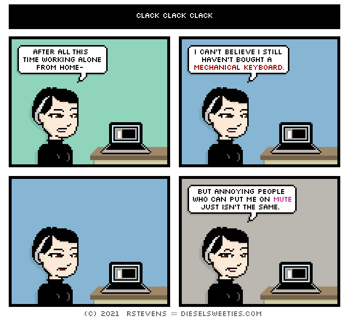
Clack Clack Clack

this is a diesel sweeties comic strip

Shout out to mechanical keyboards if you can hear me over all the racket

GATERON LOW PROFILE BROWN SWITCHES FOR LIFE

12 Feb 11:15

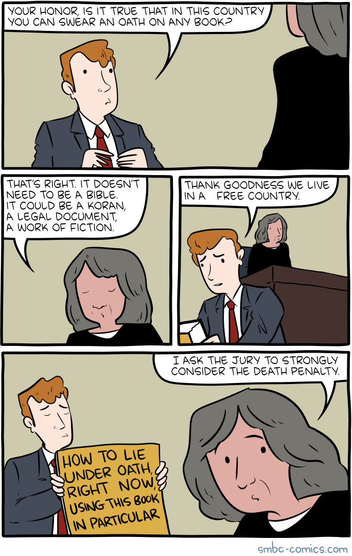
Saturday Morning Breakfast Cereal - Oath

by tech@thehiveworks.com


Click here to go see the bonus panel!

Hovertext:
What? You're saying YOUR books aren't 3 feet by 2 feet? Guess you're reading stupid stuff.


Today's News:
11 Feb 19:40

The Team

by Reza
11 Feb 18:06

The best gift

by Cassandra Calin

Happy birthday to my sweet and wonderful mum who is (slightly) obsessed with owls!

11 Feb 17:59

At Least 5 People Dead After Texas Interstate Crash Involving At Least 75 Vehicles

by Rachel Treisman
First responders arrive at the scene of a massive pile-up of vehicles on I-35W near downtown Fort Worth, Texas, on Thursday.

A Fort Worth police spokesperson said between 75 and 100 vehicles appear to have been involved in the Thursday morning crash, which authorities declared a "mass casualty event."

(Image credit: Amanda McCoy/Fort Worth Star/TNS/ABACA via Reuters)