Shared posts

31 Aug 20:59

August 31, 2023 Outlook: Idalia off to Bermuda, Franklin out to sea, but what else is out there?

by Matt Lanza

One-sentence summary

A much less intense Idalia should move toward Bermuda heading into this weekend, but there is a bit of uncertainty about what happens next week, while a couple other systems meander out to sea elsewhere.

Tropical Storm Idalia: 60 mph, moving ENE 21 mph

Idalia is moving off the coast of the Carolinas now, as it begins its march toward Bermuda.
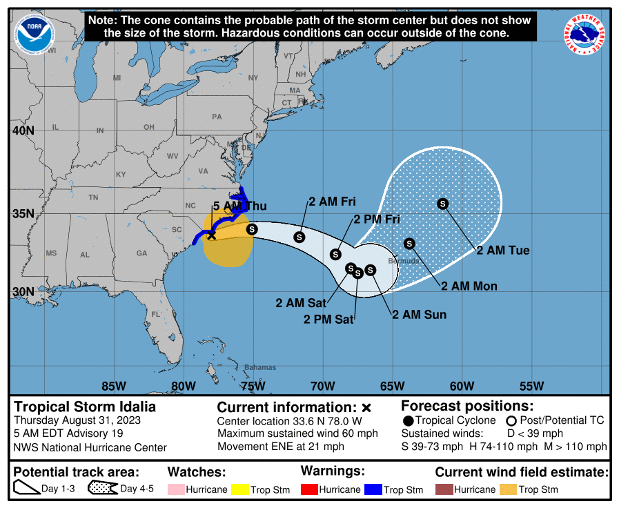
Idalia’s track will take it east and then probably eventually southeast, nearing Bermuda by later in the weekend. (NOAA NHC)

Heavy rain continues from Idalia over far east North Carolina, with some flash flood warnings posted for the Outer Banks this morning. Some locally hefty rainfall amounts are occurring in that area. Wind gusts generally in the 40 to 50 mph range with a couple exceptions have also been occurring. A tropical storm impact in this region for sure.
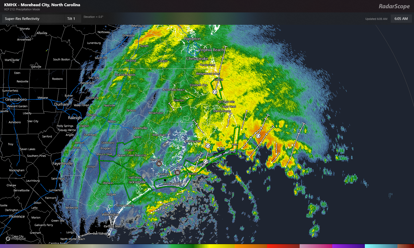
Heavy rain continues over the Outer Banks, where flash flood warnings are posted. (RadarScope)

Idalia will continue eastward today and tomorrow with gradually improving weather over the Carolinas.

As Idalia heads out to sea it should hold its own or weaken a bit further, encountering a lot of wind shear. Because of Idalia’s size, tropical storm conditions or breezy rainfall could begin in Bermuda as early as later tomorrow or Saturday.

Through day 5, the forecast for Idalia is pretty straightforward. It will slow down as it approaches Bermuda and meander for a couple days, so by Monday it’s somewhere near or north of Bermuda.

From there, things get weird. On the map below I plotted the 500 mb pattern, or what would steer Idalia at about 20,000 feet up. Areas highlighted in red indicate warmer than normal, or what we’d refer to as “above normal heights.” Areas highlighted in blue are below normal. The yellow is an overlay I did of “spin” in the mid-levels of the atmosphere to identify Idalia relative to the 500 mb pattern. Confusing? A little, but it paints a picture I can use as a meteorologist.
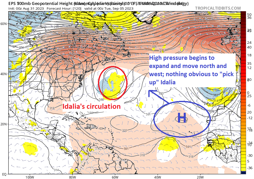
As high pressure expands over the eastern Atlantic and without any real catalyst to “pick up” Idalia, the path may begin to get weird. (Tropical Tidbits)

The lack of blue color means there is a lack of lower heights or troughs that could pick up and move Idalia. Instead, Idalia on Monday night is stuck between a rock (high pressure over the Eastern U.S.) and a hard place (building high pressure from near the Cabo Verde Islands). This should produce erratic, uncertain movement early next week. And it’s plausible that Idalia has a lack of an exit, so whatever is left of it at this point would just sit and spin. This isn’t spectacular news as this could lead to an extended period of rough surf and rip tides on the East Coast that began this week and may extend into next week.

It also does open the door up for weird things like a track back toward the coast, except in the Northeast, not Florida. A couple things to note here: Idalia may or may not be a tropical system at this point. It surely should not be a strong tropical system if it is, but it may be a broad one size-wise, which means it would be capable of rough surf or offshore gale conditions. I think once we see how Hurricane Franklin’s exit goes, we’ll have higher confidence in the early next week period, hopefully in a day or two. But in general, we have a long way to go here, so we’ll keep an eye on things. Idalia should impact Bermuda in some fashion beginning by this weekend.
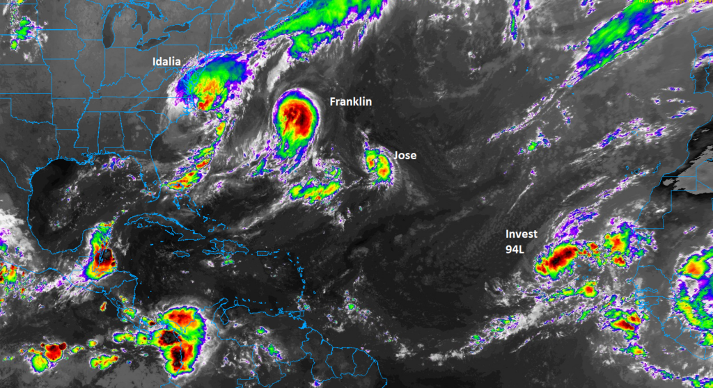
A busy Atlantic tropics continues, with 3 named storms, and a 4th area that may develop. (College of DuPage)

Elsewhere

Hurricane Franklin: 100 mph, moving ENE 15 mph

Franklin remains a category 2 hurricane, but it is beginning the process of accelerating out to sea.
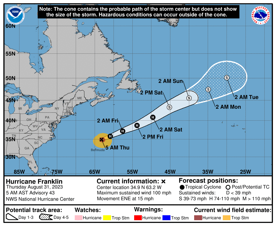
Hurricane Franklin will pick up the pace out to sea over the next 2 to 3 days. (NOAA NHC)

No other impacts to land are expected as Franklin heads out.

Tropical Storm Jose: 40 mph, moving N 5 mph

As all the chaos broke with Idalia, Tropical Depression 11 formed out in the middle of the Atlantic this week. Overnight, that became Tropical Storm Jose. This will be a short-lived storm, and there’s no way Jose will impact land.

Invest 94L

Far out in the eastern Atlantic, we have Invest 94L , which is currently over the Cabo Verde Islands. This has about a 70 percent chance of becoming a tropical system over the next few days. But it will be heading northwest or due north away from any land impacts.
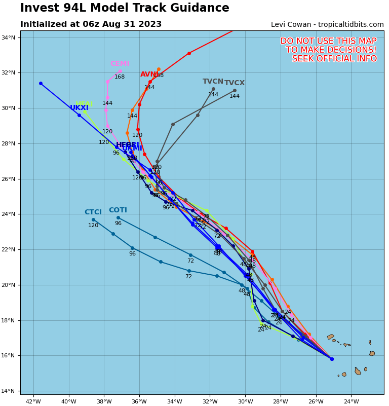
Invest 94L may become a lower-end tropical system in the coming days as it moves northwest in the open Atlantic. The next name on the list is Katia. (Tropical Tidbits)

Looking ahead

Other than monitoring Idalia, it will be a relatively quiet weekend into early next week. There are some signals of another Cabo Verde type system that could get going later next week or next weekend, but that’s far out there, and given the high uncertainty in the northern half of the Atlantic, I don’t really want to speculate on what might happen with that one.

That’s about it at the moment. We have a couple days to catch our breath and focus on hopefully lower-end impacts of Idalia in Bermuda. We’ll then see what happens next week and keep tabs on the next system emerging off Africa later next week.
31 Aug 20:57

Yes, there finally is a decent shot of rain in the forecast for Houston

by Eric Berger

Good morning. I don’t want to provide false hope to anyone, but the reality of the matter is that by Sunday, conditions for our region will start to change and favor at least the possibility of some rain showers across the metro area. We’re also looking at temperatures in the upper 90s to 100s, rather than really crazy temperatures of 105 degrees or above. So, as we move into September, we probably should embrace the small victories.

Thursday

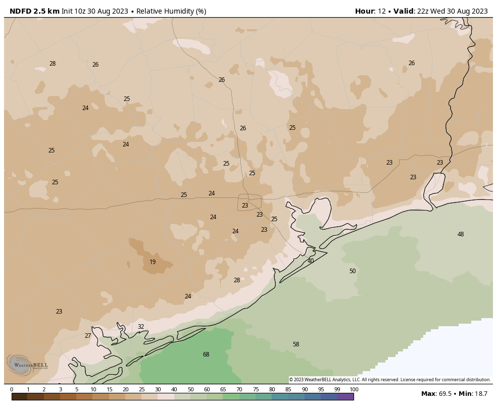
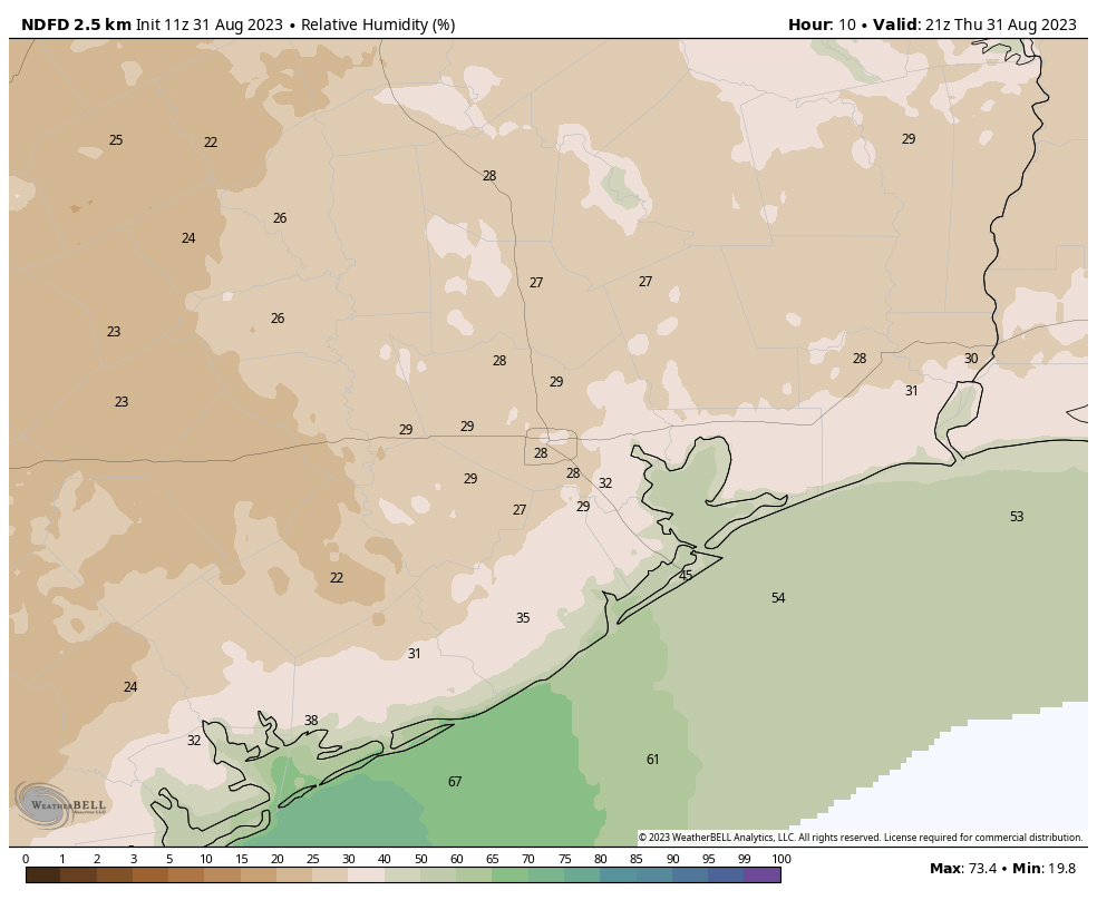
For now, there won’t be much change. After a weak front moved into the region earlier this week we’ve been seeing some drier air and it’s made for some decently nice evenings and mornings, with lower humidity and slightly lower temperatures. Daytimes remain really hot, but this is partly because dry air warms more quickly. We’ve been seeing some afternoon humidities in the 20 percents, and that should continue. Look for highs today to again be in the upper 90s to 100 degrees, with low humidity. Overnight lows should drop into the 70s, with light northeasterly winds. Skies will be sunny, and rain chances nil.

Hello, pleasant relative humidities during the afternoon! Here’s the forecast for Thursday. (Weather Bell)

Friday

Another day a lot like Thursday. Humidity levels will be a bit higher, but not much. So for Houston, in summer, it will still feel pretty dry.

Saturday

This will be a bit of a transition day, with mostly sunny skies and our formerly northerly wind shifting to come from the east. This will help start to raise humidity levels. Coastal areas may see about a 20 percent chance of rain, but for most of us it’s just going to be hot and mostly sunny, with highs of around 100 degrees.

Sunday and Monday

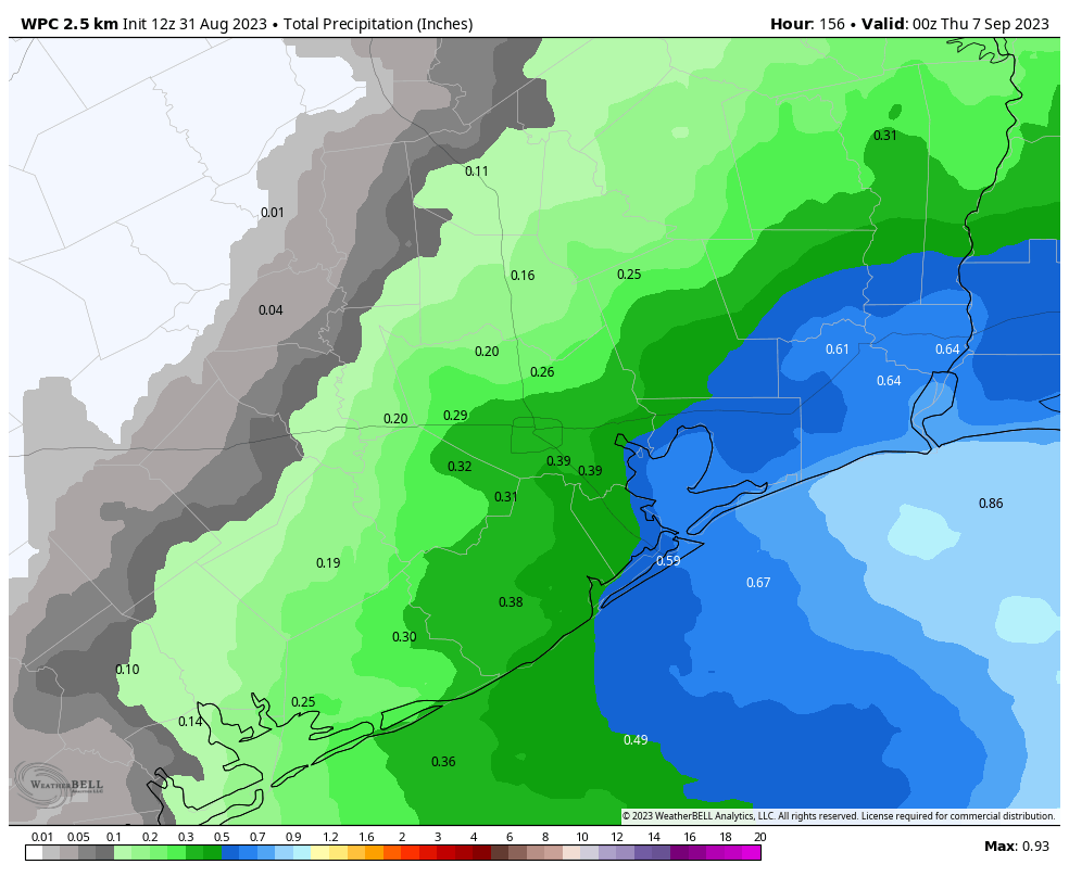
It’s Labor Day weekend, so the majority of people reading this will have Monday off from work as well. (Don’t worry, we’ll still have a report for you on Monday). By Sunday we should see high pressure start to retreat well to the north, and this will open up our region to moisture from the Gulf of Mexico and the potential for rain showers on Sunday and Monday. I’ll put chances for both days at about 60 percent for areas along and southeast of Interstate 69/Highway 59; and 40 to 50 percent for areas further inland. In terms of accumulations, we’re probably looking at a few tenths of an inch, give or take. But I would say that is far from set in stone. When it’s not raining, and it certainly won’t be most of the time, we can expect mostly sunny skies and highs generally in the upper-90s.

NOAA rain accumulation forecast for now through next Wednesday. (Weather Bell)

Next week

Rain chances look to hold on through Wednesday, after which we may return to a mostly sunny pattern, with days in the upper 90s to about 100 degrees. There are still no indications of the season’s first real cold front, but it’s probably too early to have an expectation of one.

Tropics

After ravaging the Big Bend area of Florida, as well as Georgia and parts of the Carolinas, Tropical Storm Idalia is moving into the Atlantic Ocean and away from the United States. Beyond that there is a lot of noise in the Atlantic Ocean, but nothing that really need concern us in Texas, or indeed, the rest of the United States. Full coverage of all of this can be found on The Eyewall.

31 Aug 20:56

is “return to work” a way to get people to leave, asking my boss for rides to work, and more

by Ask a Manager

This post was written by Alison Green and published on Ask a Manager.

It’s five answers to five questions. Here we go…

1. Is “return to work” a way to get people to leave?

I have a friend who works for a very large tech company that recently announced a return to work mandate. My friend insists that the company doesn’t really care about whether people are working from home. They say that the real reason the company is demanding people come back to the office is because they can’t afford their staff. My friend thinks that the company’s strategy is to force people back into the office with little justification and hope that so many people quit in response that they won’t have to initiate layoffs. Do you think this is likely? What do you think of this strategy?

That does seem to be the widespread theory! A lot of tech companies over-hired in the last few years and are well aware that requiring a return to the office means they’ll get a lot of attrition. As I wrote in a different post earlier this week, it’s a bad way to cut your numbers — it means you’re likely to lose your best people, who have the most options — but when you’re faced with needing to make enormous cuts (and pay severance to a huge number of people if you do it through layoffs), it can change the calculus.

I maintain it’s a bad strategy; if you have work-related reasons for wanting people back in the office, so be it, but changing a major policy (that influences who you’ll be able to hire and retain in the future) with the sole purpose of getting people to quit is a bad strategy. In reality, though, I suspect it’s both — they want people back in the office for Reasons, and they see it as a side benefit that it’ll shave their numbers down.

2. Employer won’t hire anyone who doesn’t wash their coffee mug after their interview

I saw an article about an employer who gives this “test” at every interview and won’t hire anyone who doesn’t pass. The gist is that he will take you down to their kitchen and offer a cup of coffee, and at the end of the interview if you take your cup back down to the kitchen and wash it, you pass. If you don’t, you fail and don’t get hired. What do you think of these types of tests?

On one hand, I can see it being a helpful thing to know if your candidate is considerate. But on the other hand, I don’t think someone who doesn’t wash a coffee cup at an interview is necessarily inconsiderate. There are many reasons I can think of that someone might not wash their cup (they don’t remember where the kitchen is and don’t want to look dumb by asking, they really need to use the restroom after drinking a whole cup of coffee, they forgot they had a cup in the first place, etc.). I also don’t like the idea of these goofy tests on the first place. Assuming you’re not interviewing for a job washing coffee cups, it seems weird to evaluate a candidate solely on that. And it’s cheesy.

It’s a terrible test! In addition to the reasons you gave, it also ignores a very common concept of hospitality, where the host handles any clean-up from the meeting and it’s not impolite to assume that they will. Plus, if you want to assess candidates for courtesy and consideration, there are lots of more direct ways to do that.

People who have secret “tests” unrelated to the job itself generally think their methods are brilliant and are utterly unaware of how flawed they typically are — which correlates strongly with not knowing to interview effectively and screen for what they actually need.

3. Can I ask my manager to drive me to work in the winter?

I’m starting my first internship (required by my degree) in a few weeks. I’m excited but a little nervous. I live somewhere where it snows quite a bit, and I’m concerned about how I will physically get to the building once winter starts. I can’t drive. There’s a pretty good bus system here, but I still get a little panicky thinking about walking a block in knee-deep snow from the bus stop to where I’ll be working.

When I interviewed for the internship, my future boss told me she got excited seeing the address on my resume. Apparently, we live very close to one another, within minutes. She probably passes by my apartment on the way to work.

Would it be weird/unprofessional if I asked her if she’d be willing to give me a ride once winter hits? If it helps, she seems like a very warm, mom-to-everyone kind of person. The second I walked in to interview, she offered me a sandwich and a soda before I’d even really introduced myself.

It’s fine to ask very occasionally in particularly bad weather — but don’t ask for her to do it as an regular thing. For a lot of people, that would be a pretty big imposition. If she offers it on her own — which she might at some point — that’s a different thing, but it’s not something you should request.

(Also, I know this was only a throw-away comment in your letter and I don’t want to read too much into it — but she’s not an office mom! It’s can be really undermining to women to be tagged with that label. Maybe she’s a kind, supportive, or thoughtful manager … but not she’s not being maternal, any more than a man who cares about the people working for him is being paternal.)

4. My boss took off two weeks with no notice

This is my first time working in a job where salaried employees have “unlimited vacation” as long as they are attending to their job duties. Last week, my boss announced on Monday that they were off for the week. Last Thursday, they cancelled all of their meetings for this week and announced they’d see us after Labor Day. So no management available for two weeks, notified the the day it started.

I am a project situation that requires management input, as well as certain timely things that require their approval before happening, for which no alternate arrangements have been made. We are in the middle of several timely projects, which without their input require me to shoulder additional responsibility (and hours) that I could not plan ahead for. There’s no one above my boss who could help. This is really bothering me, and adding significant stress to my position.

With unlimited vacation, is it considered reasonable announce that day that you’re taking a week off? And then extend it with a weekend’s notice? I want to know if I need to adjust my thinking to understand that this could happen in any future workplace.

There are jobs where you absolutely could announce the day of that you’re taking a week off — jobs where you manage your own workload and can make plans for anything that needs to be covered in your absence to be covered or where you have the authority to decide that it’s okay to put things on hold. There are also jobs where you definitely couldn’t. And there are jobs in-between, where you could do that once but if you started doing it multiple times, someone would ask you to give more notice.

When you manage people, though, you shouldn’t do this without an explicit conversation with the people you manage about what your absence will mean for their work (unless it’s obvious that it will mean nothing — which isn’t the case for you). Your boss dropped the ball by not doing that.

You asked if you should expect this could happen in any future workplace and sure, it could. The more senior someone is, the more control they’ll generally have over their own schedule, which can include last-minute time off. But generally if you have a manager who’s reasonably on top of things, they won’t do what your boss did to you — or if they do, you can point it out once they’re back and ask for different arrangements in the future, or you can just call them and say, “Before you disconnect, we need to talk about X, Y, and Z.”

5. What are my responsibilities after giving notice?

I recently gave three weeks notice at my job and am serving that time out right now. My boss and I are a two-person department so presumably a lot of work will fall on her, but no one has once approached me to ask what I do, what needs to be taken over, how to do things I’m in charge of, etc. I trained my boss on her job and know she certainly can’t do mine, because it’s very admin/computer heavy and she’s borderline technology illiterate. Do I need to approach her/other management now that it’s my last week and give an overview of what will need to happen when I leave? Or does them not asking me mean it’s not a concern so to let it go?

This is something your boss should be managing. If she’s not, it’s not on you to go over her head to try to make it happen. However, as part of being generally conscientious, it would make sense to ask your boss if she wants to meet to go over transition items, or if there’s anyone she wants you to train on X or Y. Ideally you’d also leave behind documentation of where projects stand, key things a replacement will need to know, etc. so that you can direct her to it when you leave.

31 Aug 20:51

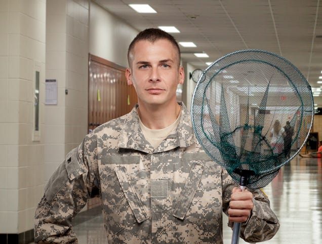
Army Recruiter Standing In High School Hallway Holding Net

31 Aug 20:48

Couple Turns To IVF After Struggling To Have Octuplets

RICHMOND, VA—Visiting a fertility clinic in the hopes of finally having the family they always wanted, local couple Tim and Caroline Stauber told reporters Thursday they had turned to in vitro fertilization after struggling to have octuplets. “We’ve tried for years with no success, so at this point, our best chance…

Read more...

31 Aug 20:48

Biden Warns Zelensky If He Can’t Win War, U.S. Will Overthrow Him With Someone Who Will

WASHINGTON—Telling his counterpart that he was losing patience with the stalled counteroffensive, President Joe Biden reportedly warned Volodymyr Zelensky Thursday that if the Ukrainian president couldn’t win the war against Russia, the United States would overthrow him and replace him with someone who would. “Our…

Read more...

31 Aug 20:48

Twitter Lifts Years-Long Ban On Political Ads

Twitter announced that it’s lifting its years-long ban on political advertisements, enabling candidates to freely purchase ads again in the U.S. to build on their “commitment to free expression.” What do you think?

Read more...

31 Aug 20:46

My Friends

by Reza
31 Aug 20:44

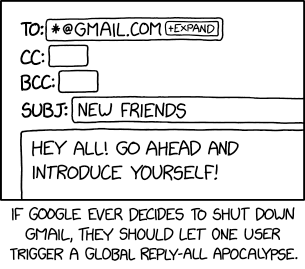
*@gmail.com

Hi all, just replying to loop in *@outlook.com and *@yahoo.com.
31 Aug 20:41

Dog autism? 37% of US dog owners buy into anti-vaccine nonsense

by Beth Mole
A very good boy gets a check-up with a veterinarian.

Enlarge / A very good boy gets a check-up with a veterinarian. (credit: Getty | Arne Dedert)

The anti-vaccine rhetoric that dogged COVID-19 responses has now gone to the dogs, literally.

A little more than half of surveyed dog owners—53 percent—questioned the safety, efficacy, and/or necessity of vaccinating their beloved four-legged family members. The study, published recently in the journal Vaccine, involved a nationally representative group of 2,200 American adults, of which 42 percent (924) made up the analyzed subgroup of dog owners. Overall, the findings add to concern that the anti-vaccine sentiments that flared amid the pandemic have fanned out broadly, undermining even routine childhood vaccinations.

That concern was supported by the new study, which found that the dog owners who espoused "canine vaccine hesitancy," or CVH, were more likely to embrace misinformation and falsehoods linked to human vaccines. And those anti-vaccine beliefs were potent. Responses from the CVH dog owners suggested that 56 percent opposed mandatory vaccination against rabies, a 100 percent fatal condition.

Read 9 remaining paragraphs | Comments

30 Aug 20:59

Rudy Giuliani is liable for defaming 2 Georgia election workers, a judge says

by Jaclyn Diaz
Rudy Giuliani speaks outside the Fulton County jail in Atlanta on Aug. 23, before he surrendered on 13 felony charges related to efforts to try to overturn the 2020 election.

Judge Beryl Howell's decision means that a trial will commence in this case to decide how much Rudy Giuliani must pay Ruby Freeman and Wandrea "Shaye" Moss.

(Image credit: Brynn Anderson/AP)

30 Aug 20:58

Photos: See the aftermath of Hurricane Idalia

by LA Johnson
Makatla Ritchter wades through flood waters after having to evacuate her home when the flood waters from Hurricane Idalia inundated it on August 30, 2023 in Tarpon Springs, Florida.

The hurricane was downgraded to a Category 3 before making landfall in Florida Wednesday. Storm surge had residents worried as they watch the waters rise.

(Image credit: Joe Raedle/Getty Images)

30 Aug 20:55

Idalia approaches landfall in Florida’s Big Bend as a category 4 hurricane

by Matt Lanza

Editor’s note: Idalia made landfall with estimated 125 mph winds, making it a category 3 major hurricane

One-sentence summary

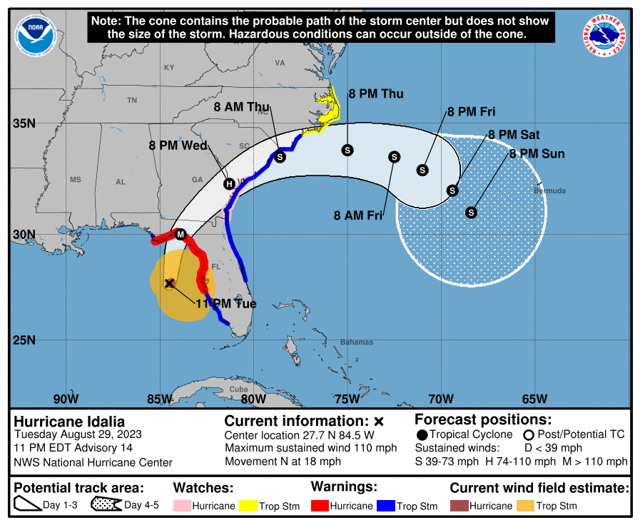
Idalia is about to make landfall as a category 4 hurricane in Taylor County, FL, with catastrophic storm surge in the Big Bend and wind, tide, and rain impacts spreading north into Georgia and the Carolinas later.

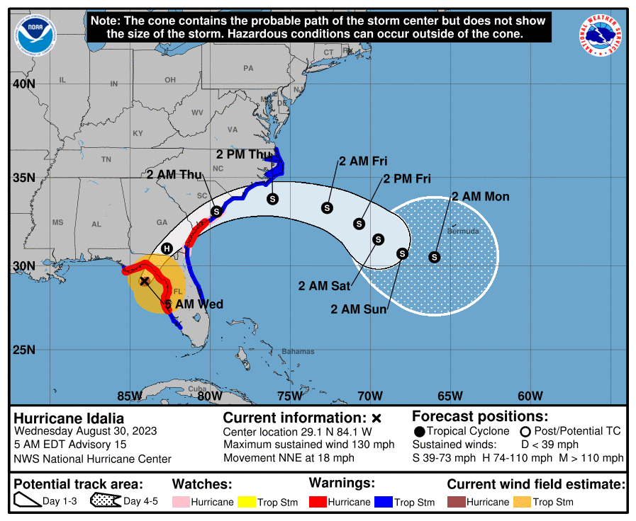
Idalia will track into Georgia and South Carolina today before exiting offshore. (NOAA NHC)

Hurricane Idalia: 130 mph, moving north-northeast at 18 mph

Idalia looks prepared to make landfall on the eastern side of Apalachee Bay in Taylor County or on the Taylor/Dixie County line.

What’s changed since late last night?

Idalia is now a category 4 major hurricane with 130 mph maximum sustained winds. It is nearing landfall. Because of Idalia’s fast forward speed, hurricane warnings are now in effect on the East Coast from just north of St. Simons Island, GA to Edisto Beach, SC. Storm Surge Warnings are also posted from St. Catherine’s Sound in Georgia to the South Santee River in South Carolina. Tropical Storm Warnings are in effect north from Surf City, NC to the North Carolina and Virginia border.

Forecast tides in South Carolina are a little higher today.

An extreme wind warning is in effect for Taylor and portions of Dixie County, FL as Idalia approaches landfall.

Idalia’s surge

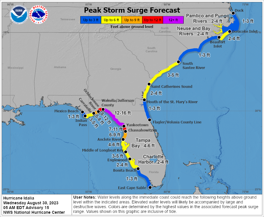
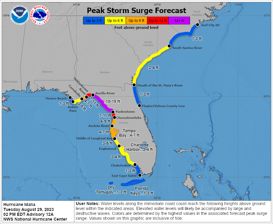
The storm surge forecast remains on track in Florida, with a little expansion of surge this morning forecast for the South Carolina coast, now up to 3 to 5 feet in the Charleston area.

Catastrophic storm surge is expected this morning in the Big Bend of Florida. (NOAA NHC)

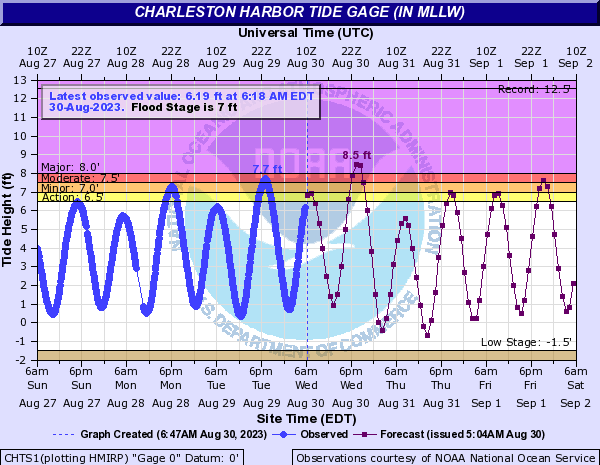
With Idalia coming ashore in Taylor County in all likelihood, surge may be a bit under the forecast west of the Taylor/Jefferson County line. This is accounted for in the map above, but it may even drop off a bit faster than shown. Still, as much as 12 to 16 feet of surge should be in the process of rolling ashore in the Big Bend. Charleston’s forecast is now up to 8.5 foot tidal levels in the harbor.

Charleston should see tides into major flood levels, peaking around 8.5 feet. (NOAA)

This is now forecast to be up to about November 2021 levels and close to cracking Charleston’s top 10 list.

There has not been much change in Savannah this morning, with a 10.3 foot crest expected.

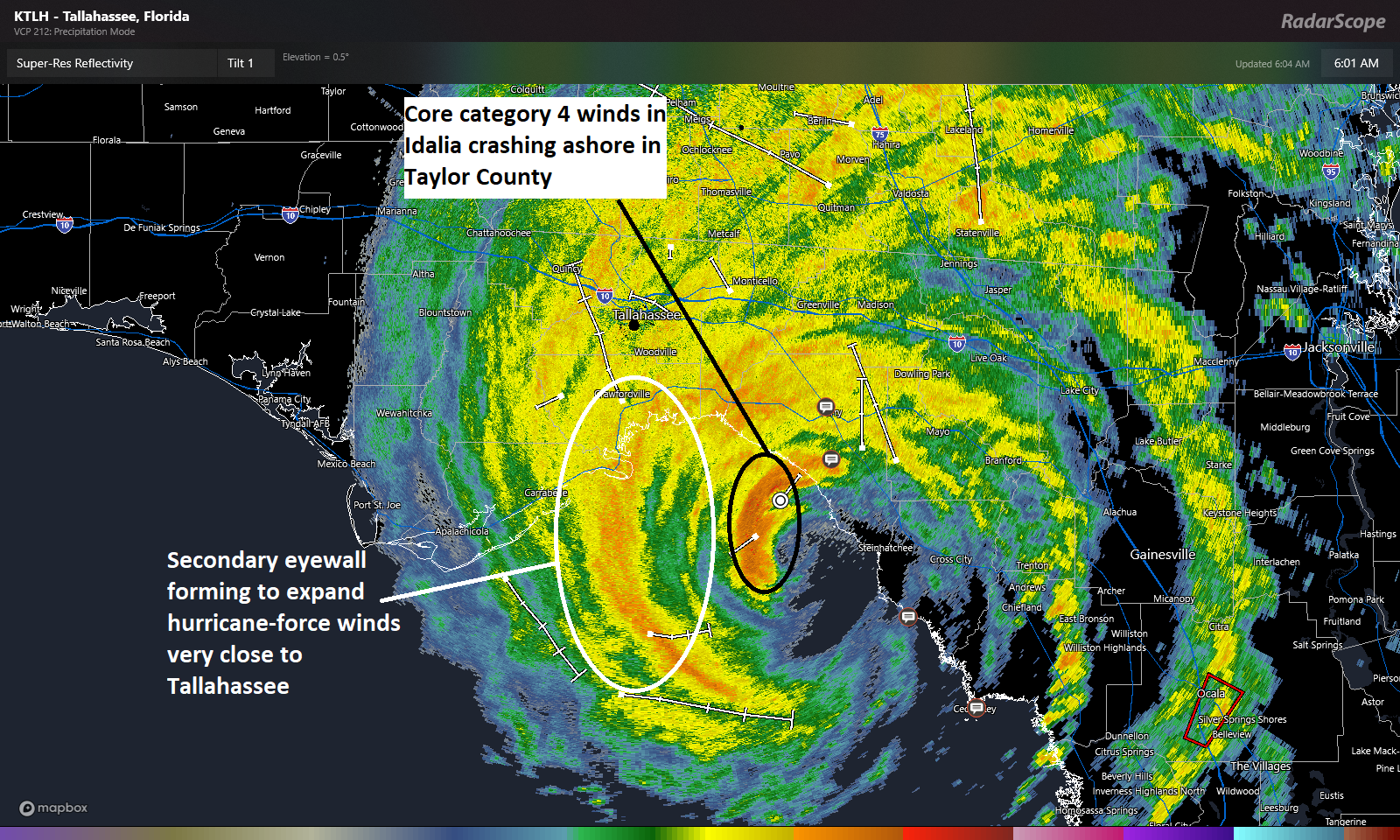
Idalia’s catastrophic category 4 winds will be in a small area but drive right into Perry, FL, while strong winds are likely to extend out from there into a secondary eyewall that will likely graze Tallahassee. (RadarScope)

Idalia’s wind

The core of Idalia’s category 4 winds, the real catastrophic winds will push into Taylor County, FL and right toward Perry, FL over the next hour or two. Those will cross I-10 near or west of Live Oak in all likelihood. Strong winds are likely in a secondary eyewall forming to expand Idalia’s wind field this morning. That will push inland on the west side of Apalachee Bay and come very close to Tallahassee.

Idalia’s wind field is expanding but the intensity will gradually lessen as Idalia push inland and weakens. Still, this storm will be capable of big wind and many power outages as it comes north and east.

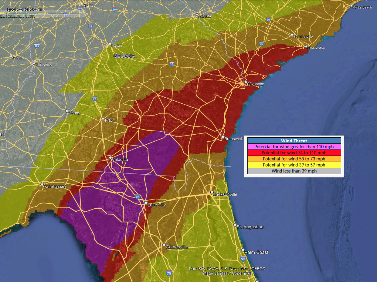
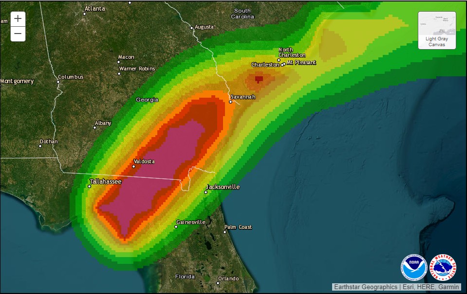
Because of Idalia’s forward speed, strong damaging winds will expand into southeast Georgia, likely just east of Valdosta. Hurricane-force winds are possible into coastal Georgia and south of Charleston, SC. (NOAA)

The strongest winds will hopefully avoid Valdosta, but much of southeast Georgia will see very strong winds as Idalia races northeast. Hurricane-force winds will also be possible in southeast South Carolina.

Idalia’s tornadoes

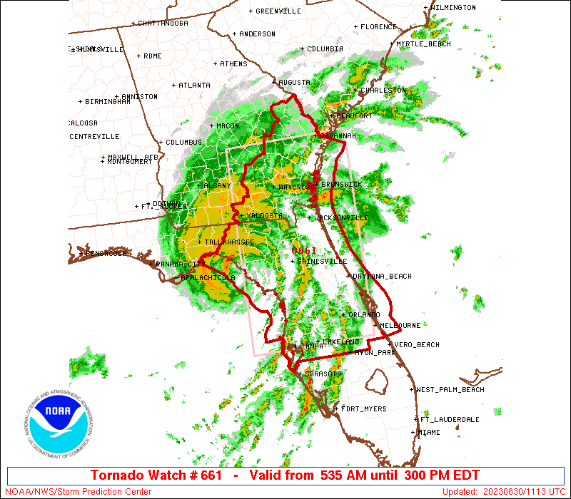
A Tornado Watch is posted for most of North Florida and southeast Georgia through mid-afternoon.

Isolated tornadoes are possible on the east side of Idalia’s track. (NOAA SPC)

Tropical systems do produce isolated tornadoes, so this will be a possibility anywhere in the watch area.

Idalia’s rain

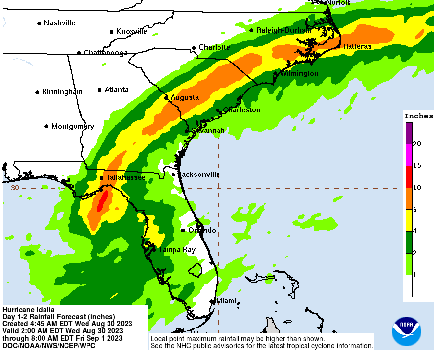
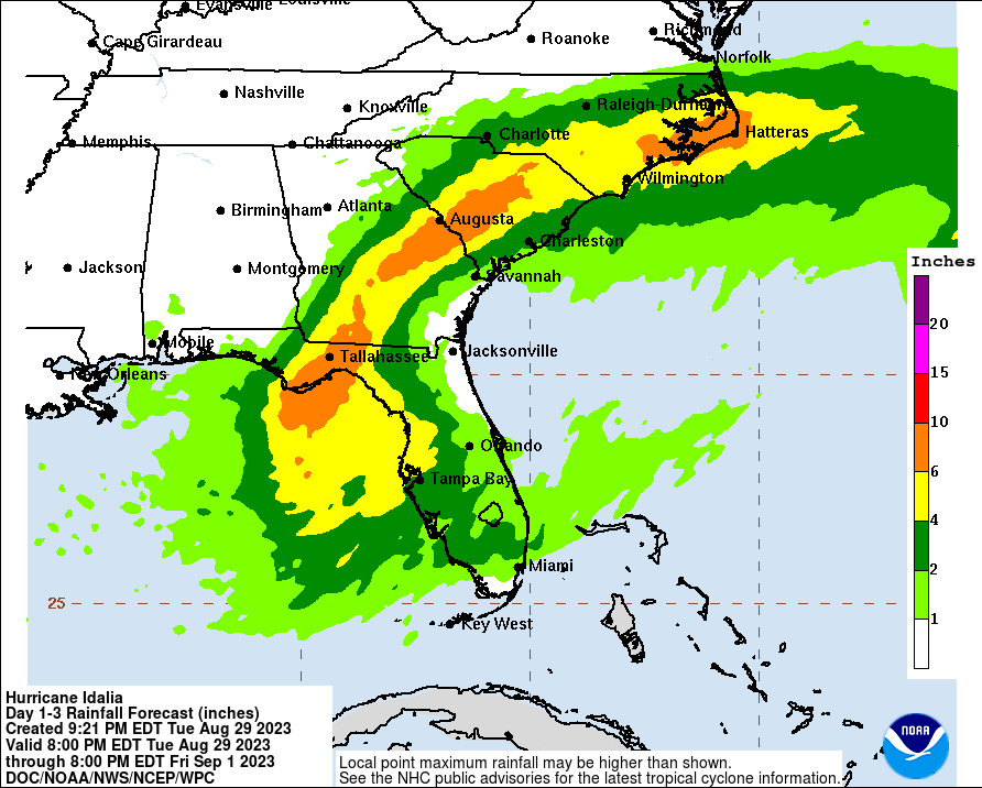
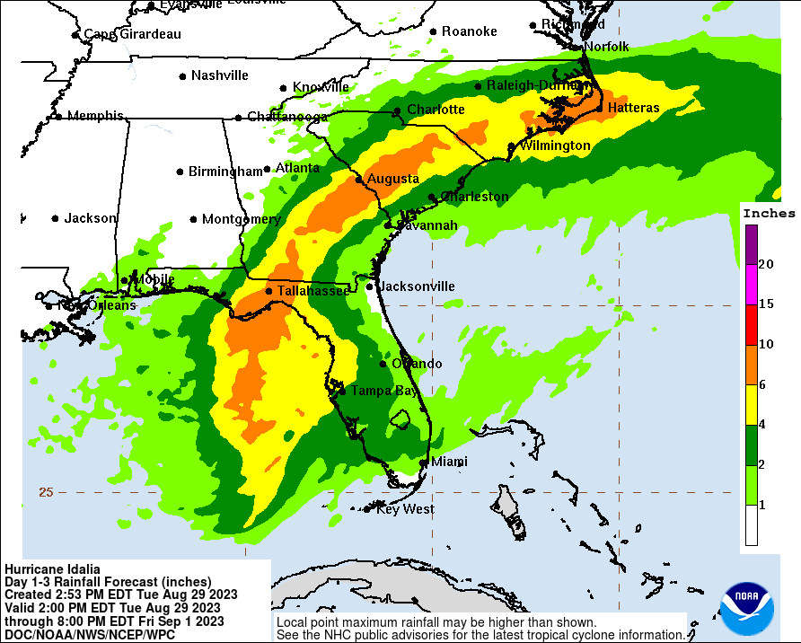
Idalia is expected to produce a narrow but lengthy corridor of 6 to 10 inches of rain into southeast North Carolina.

Idalia will produce a swath of 6 to 10 inches of rain into southeast North Carolina, likely causing flash flooding in spots as it comes northeast (NOAA)

Flash flooding is likely in spots as it comes northward.

Our next update will be posted around Noon ET with the latest on Idalia as it comes northeast.

30 Aug 20:48

Idalia cruising across Florida-Georgia line, bringing strong winds, lashing surge, and heavy rains through the Carolinas

by Eric Berger

One-sentence summary

Idalia make landfall near Keaton Beach, Florida, at 7:45 am ET this morning as a Category 3 hurricane with sustained 125-mph winds. The hurricane will continue to produce significant impacts on Florida and other southern states for about the next 24 to 36 hours before it exits into the Atlantic Ocean.

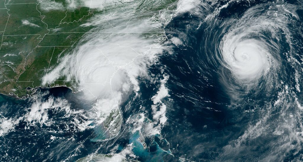
A satellite image of Idalia shortly before Noon ET on Wednesday. That’s Hurricane Franklin spinning in the Atlantic, away from land. (NOAA)

Storm surge

Let’s start with storm surge, which has been considerable in Florida’s Big Bend area. This part of the state has a relatively low population, but Idalia has still been flooding villages and knocking down trees in northern Florida. Peak storm surge levels were about 10 feet, or higher, in the Keaton Beach areas and further south down the coast, toward Yankeetown. As expected, Idalia came in far enough north of the Tampa region on Florida’s Gulf coast to spare that large metro area from its worst effects.

The other area of concern, in terms of surge, is along the coast of South Carolina, particularly near Charleston. Moderate to major flooding is expected in coastal South Carolina later this afternoon when Idalia’s storm surge combines with high tide.

Damaging winds

Idalia briefly reached Category 4 status this morning, but started weakening just before landfall early on Wednesday. This weakening was due to the storm undergoing an eyewall replacement cycle, a process by which an older eyewall weakens and a new one forms. After coming ashore, as storms typically do, this interaction with land has rapidly reduced Idalia’s maximum sustained winds. As of 11 am ET, the National Hurricane Center says they have fallen to 90 mph.

Areas in darker shades of red are most at risk for sustained winds of 60 mph or higher. (National Hurricane Center)

This is still strong enough to uproot trees and down power lines, however. This will be a significant problem in northern Florida, and southern Georgia and South Carolina. Idalia is expected to weaken to just below hurricane strength before moving into the Atlantic Ocean on Thursday morning.

Inland rainfall

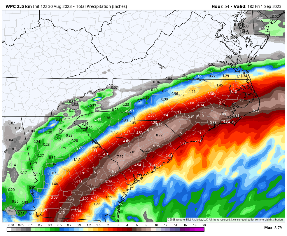
Despite Idalia’s relatively rapid forward movement, it is still expected to produce a significant amount of rainfall along its track across the Southeastern United States, including North and South Carolina. Some areas may see as much as 6 to 10 inches of rainfall in total, and a major concern is rainfall rates.

Tropical storms can produce some of the most explosive rainfall rates, which quickly back up drainage systems. Already, this morning, there have been reports of 5 inch-per-hour rainfall rates in Southern Georgia, which will cause significant inland flooding.

NOAA rainfall accumulation forecast for Idalia. (Weather Bell)

A rare location for such a storm

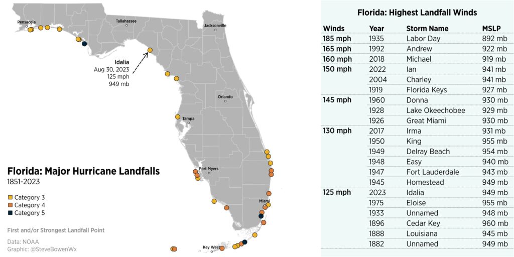
Meteorologist Steve Bowen has plotted the 21 known hurricanes, since 1851, to strike the Florida peninsula. Many of these storms were clustered in Southern Florida, with only a small handful in the Big Bend region of Florida. The strongest of these, Hurricane Michael, made landfall in 2018 with 160 mph winds.

Florida’s major hurricane landfalls. (Steve Bowen)

Our next update will be today by around 5 pm Eastern.

30 Aug 20:37

Dry air maxes out today, but less humidity means a greater danger of wildfires

by Eric Berger

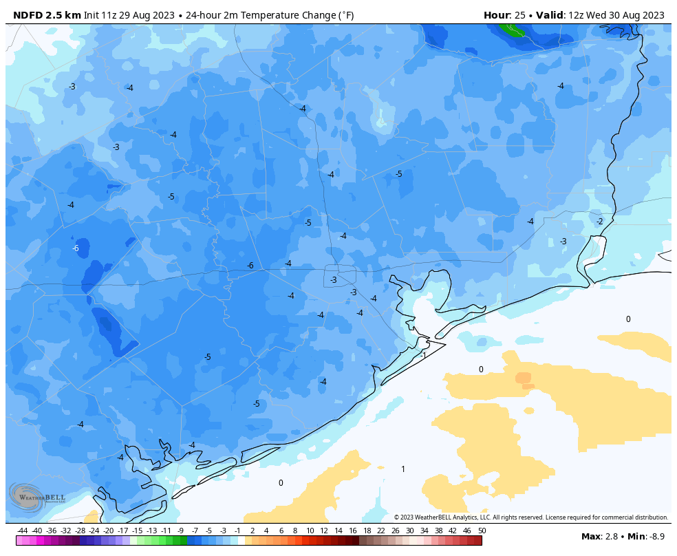
Good morning. Temperatures have reached the 60s for some inland locations, with much of the rest of Houston in the low- to mid-70s. With lower dew points it feels, dare I say, almost sort of pleasant outside? Thanks to a front that pushed offshore earlier this week we’ll continue to see drier air through about Friday morning. But because dry air warms quickly, we’re still going to see hot days, with highs in the upper 90s to 100 degrees. Evenings will cool off more quickly, however.

Due to the lower humidity, and somewhat breezy conditions, a “red flag” warning is in effect for pretty much the entire region. This combination of winds, low relative humidity, and warm temperatures will create the potential for explosive fire growth. Please avoid all outside burning. Do not toss lit cigarette butts outside. Report wildfires to the nearest fire department or law enforcement office.

Relative humidity levels will drop below 30 percent for much of the region this afternoon. (Weather Bell)

Wednesday

High temperatures today will reach about 100 degrees for much of the metro area, but with dew points this afternoon dropping into the 50s, it genuinely will be a fairly dry heat. Close your eyes, and you’ll be able to pretend you’re in Arizona. Skies will be sunny. Winds will be out of the northeast, mostly, today at 10 mph with higher gusts to about 20 mph. Lows on Wednesday night should again drop into the 70s for much of the area.

Thursday and Friday

These days will also see a fair bit of drier air, although dew points will slowly be coming back up. Skies will be sunny, with highs of about 100 degrees. Again, mornings and nights should be fairly pleasant, at least for this time of year.

Saturday and Sunday

The weekend will see more mostly sunny skies, and highs of around 100 degrees. Humidity, alas, will be back. However, along with it we’ll see some decent rain chances. Coastal areas probably have about a 30 percent chance of a shower on Saturday, and most of the region that much of a shot on Sunday.

NOAA rain accumulation forecast for now through Tuesday. (Weather Bell)

Labor Day and beyond

Rain chances likely peak on Labor Day, with perhaps a 40 or 50 percent chance of seeing a passing shower. These are not, for the most part, likely to be drenching and long-lasting rains. But any showers are welcome, and they’ll also cool the air. Look for highs in the upper 90s on the holiday.

Most of next week should see continued highs in the vicinity of the upper 90s, with decent rain chances on the order of 30 percent daily, or so. High pressure will be far enough to our west that some sea breeze storms will be possible. There are still no signs of truly widespread rain, which is needed to break the region’s drought, alas.

Strong damaging winds from Idalia will expand into southeast Georgia, likely just east of Valdosta. Hurricane-force winds are possible into coastal Georgia and south of Charleston, SC. (NOAA)

Tropics

Unfortunately, but not unexpectedly, Hurricane Idalia has blown up into a Category 4 storm overnight. Idalia is about to make landfall in Taylor County, FL, with catastrophic storm surge in the Big Bend and wind, tide, and rain impacts spreading north into Georgia and the Carolinas later. We will have full and ongoing coverage of the storm today on The Eyewall. Beyond Idalia there are no areas of concern in the tropics, as far as impacts to the United States and Caribbean Islands are concerned.

30 Aug 20:29

New U.S. Army Recruitment Ad Touts Military As Great Alternative To Starving On Streets

WASHINGTON—In an effort to reach Americans affected by growing income inequality and the soaring cost of food, the U.S. Army launched a new ad campaign this week that touts the military as a great alternative to starving on the streets. “Food, sustenance, grub, chow—whatever you call it, we have it, and you need it…

Read more...

30 Aug 11:07

Idalia about to become a major hurricane and will deliver catastrophic storm surge to the Big Bend and portions of Apalachee Bay

by Matt Lanza

One-sentence summary

Hurricane Idalia is expected to make landfall in the morning as a category 4 major hurricane, bringing catastrophic storm surge to the Florida Big Bend region and Apalachee Bay, an unprecedented storm in modern history for this region.

The forecast for Hurricane Idalia suggests at category 4 storm at landfall tomorrow morning in Apalachee Bay. (NOAA NHC)

Hurricane Idalia: 110 mph, moving North at 18 mph

As of the 11 PM ET advisory, Idalia is on the cusp of becoming a major category 3 hurricane. Idalia is beginning to take on “the look” when you look at satellite imagery. Unfortunately, if you’ve watched the Gulf since 2017, when a storm takes on “the look,” it usually means the forecast of a major storm with major impacts will verify. We’re in that boat tonight.

Hurricane Idalia is beginning to acquire “the look” we have come to know and dread in the Gulf of Mexico in recent years. (Tropical Tidbits)

What’s changed since late afternoon?

A few notable changes: First the storm track has shifted the landfall point even a little farther west, now in the middle of Apalachee Bay. This has implications on Tallahassee discussed below.

Second, storm surge heights have increased. They are now as high as 12 to 16 feet above ground level in the eastern portion of Apalachee Bay and the Big Bend. Basically St. Marks to Yankeetown is likely to be completely inundated with deep water. Surge heights are slowly being trimmed back on the southwest coast of Florida up through Tampa as Idalia accelerates north.

Surge forecasts have been added for North Carolina now, with perhaps as much as 2 to 4 feet in some of the mainland shores of Pamlico Sound, as well as near Cape Lookout.

Surge update

Catastrophic surge is expected in the Florida Big Bend. Not much else to say here. There’s been little change since earlier this evening in terms of this impact. The forecast has shuffled a bit with 12 to 16 feet of surge now as far west as the Wakulla/Jefferson County line, just east of St. Marks. We continue to believe this will come into an area with no real modern historic precedent of this level of hurricane hitting (best comp perhaps being in the late 1800s).

Storm surge is now expected to be as high as 12 to 16 feet above ground level in the eastern half of Apalachee Bay and the Big Bend, an absolutely catastrophic amount of water. (NOAA NHC)

This is the last warning folks in the relatively rural Big Bend have to get out. These smaller communities will need a lot of help in the days ahead.

Wind update

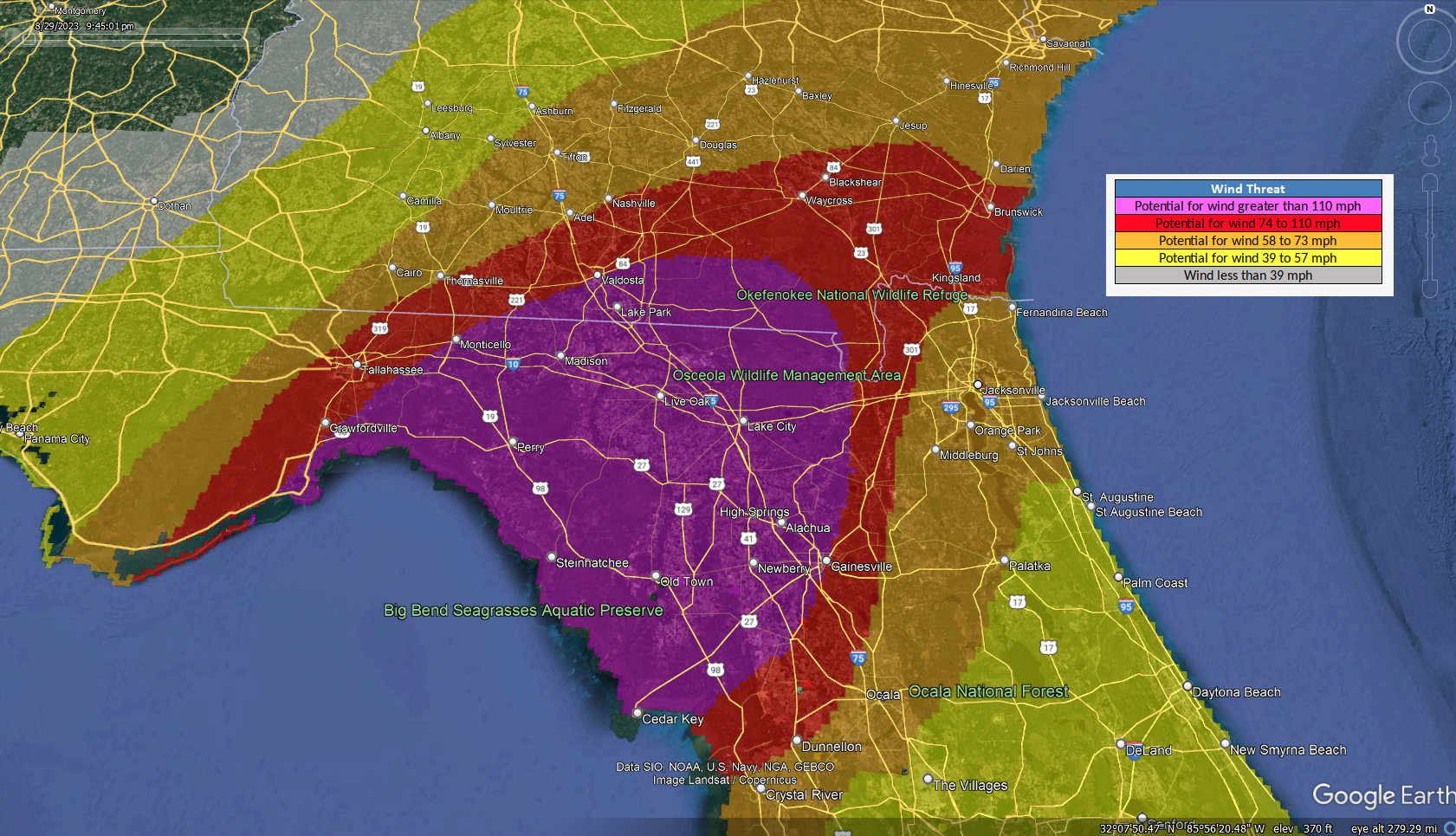
The core of strongest wind is expected to be just east of Tallahassee across much of the Big Bend into much of north-central Florida and far south Georgia. Live Oak, Lake City, Alachua, and Valdosta may all see significant hurricane-force winds. Considerable wind will also be possible as Idalia moves into Georgia, so communities like Waycross, Kingsland, or even Brunswick could see strong winds.

Purple, the area of worst wind potential may nudge a little left (west) depending on Idalia’s exact track. But much of the Big Bend and north-central Florida will see significant hurricane-force winds. (NOAA)

The exact location of these strong winds may maneuver a little west if Idalia’s track shifts any farther that direction.

Tallahassee

For the city of Tallahassee, the track of Idalia has not trended kindly today. The slight nudge west today has kept Tallahassee in play for the western eyewall of Idalia as it comes ashore. What does this mean? It means that most of the city will either see generic damaging winds (hurricane-force gusts, mostly) or sustained hurricane-force winds and widespread damage potential. There may even be a relatively noticeable east to west gradient of damage, with more of it on the east side and less to the west. We’ve gotten no real additional clarity tonight on exactly how close that will come, but suffice to say, it will be close.

Rainfall from Idalia

Idalia is expected to be a pretty healthy rainmaker as it comes north. Flood watches extend from Florida into North Carolina now. There will be corridor of 6 to 10 inches of rain up the coast, just inland, basically along and west of I-95, depending on exactly how Idalia tracks.

The rain forecast from Idalia is not significantly changed tonight, with 6 to 10 inches possible in interior south Georgia and South Carolina, as well as in portions of southeast North Carolina. (NOAA)

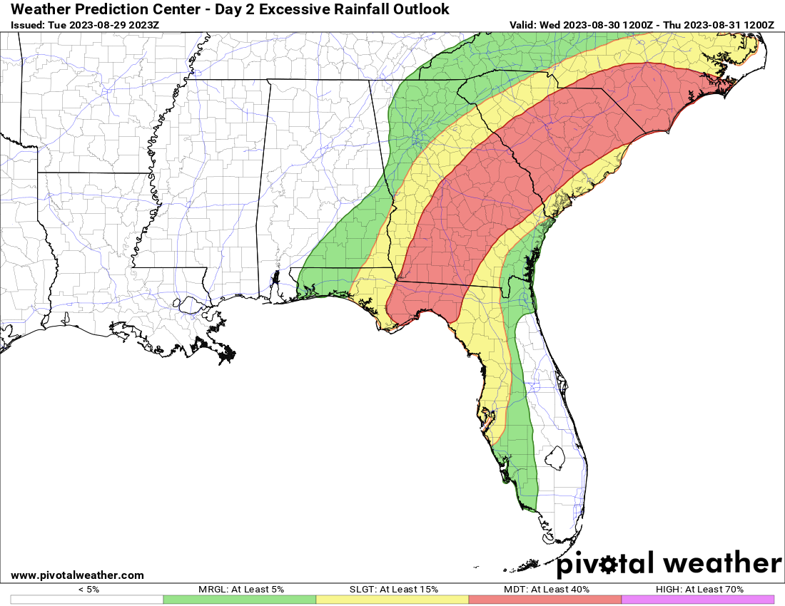
I think North Carolina bears some watching, as there is a sign in some modeling for an area of enhanced rainfall from about Cape Hatteras south and west onto the mainland near New Bern where amounts toward the higher end of the forecast range are possible. The Weather Prediction Center has a “moderate” risk (level 3/4) for this region for excessive rainfall and flooding for Wednesday.

The excessive rainfall outlook on Wednesday is at “moderate,” level 3 of 4, which means flash flooding is a good bet in some areas. I especially think SE North Carolina bears some watching tomorrow night. (Pivotal Weather)

Thankfully, Idalia should be moving offshore by Thursday morning, ending the rain threat in the Carolinas and Georgia.

As is always the case, isolated tornadoes do occur with landfalling tropical cyclones, and Idalia should be no different. The highest chances of a tornado would be in North Florida, coastal Georgia or coastal South Carolina.

Charleston, Savannah, and Jacksonville

We continue to monitor the risk of storm surge and coastal flooding in some of the larger metro areas on the Atlantic coast, in particular Charleston, Savannah, and Jacksonville.

For JAX, this should be hopefully mostly a nuisance event, with wind gusts to 50 mph and about 1 to 3 feet of surge. This would produce mostly minor to moderate flooding in the Jacksonville area.

In Savannah, winds could be stronger, as it will be closer to Idalia’s center when it comes by, so gusts of up to 70 mph are possible there. In addition, up to 4 feet of water above ground level is possible.

The Fort Pulaski tide gage, just downriver from Savannah is expected to peak with “moderate” tidal flooding levels. (NOAA)

The 10.3 foot forecast at the Fort Pulaski tide gage would be the highest since last November’s 10.41 foot level. This is associated with moderate coastal flooding.

In Charleston, the Harbor is still forecast to get to 8.3 feet, which qualifies as “major” tidal flooding. Of course, coastal flooding is a scourge in Charleston, and this level was achieved as recently as June of this summer.

Although tidal flooding is common in Charleston, with this forecast level being seen as recently as June, the heavy rain and wind may lead to slightly worse than usual impacts from this level of water. (NOAA)

Charleston should see wind gusts as high as 60 mph with Idalia as it passes by, which may in combination with heavy rain complicate drainage of water a bit, making this tidal level a little worse than what would normally be expected with 8.3 foot tides.

The second act

Once again, I just want to close out on this: Don’t worry about the second act of Idalia, as some models show it looping back toward Florida heading into next week. It’s simply not a relevant concern at the moment and the storm would likely be a shell of itself if it happened that way. We are not concerned right now about this coming to fruition in a serious manner. The focus should be on impacts tonight and tomorrow.

Our next post will aim to come at you around 7:30 AM ET Wednesday.

30 Aug 10:57

a work baby shower without gifts, using sick time for psychedelic therapy, and more

by Ask a Manager

This post was written by Alison Green and published on Ask a Manager.

It’s five answers to five questions. Here we go…

1. A virtual baby shower … with no shower

I work for a primarily remote company, and last fall I gave birth to my second child. Our small team (less than 20) comprises mostly women in their late 20s-early 30s, and I’m in my late 30s. A few weeks before my due date, I was surprised with a calendar invite for my virtual team baby shower. I was surprised because no one asked me whether I wanted to have a baby shower, and no one asked about my registry or if I had a preference for gifts. There was another team member whose wife was also pregnant, so this was a joint baby shower.

Overall it was fine, though a little awkward over Zoom. We played a game where we tried to guess which baby photos were of which team members. However, there was no gifting involved whatsoever. It seemed like it was just an acknowledgement that babies were on the way. I can’t help feeling that the organizers, being a bit younger, maybe haven’t been to a baby shower and didn’t know that the “shower” aspect means gift-giving? And I wonder if the other attendees assumed that the parent company sent me a gift of some sort, and whether anyone feels slighted that I didn’t send a thank-you note in return?

As small as this is, it has stuck with me. I think the time for bringing it up has certainly passed, but my instinct is to get involved in the planning of any future showers to ensure the expectant family is celebrated in the way most helpful for them. These issues are certainly small potatoes, but as a gut-check, am I being petty?

You’re not being petty, but you’re missing the fact that work showers are often more about celebrating the impending birth than giving gifts. It’s true that normally the whole point of a shower is to “shower” the expectant parents with things for the baby … but at work, there’s a competing (and more important) principle of “don’t pressure people to spend money on work celebrations.” Some offices resolve that by having the party with the gift-giving removed.

However, your coworkers shouldn’t throw showers for people without asking if they want one first! Some people won’t want one for personal reasons, and some people don’t do them for religious reasons. So if you’re able to influence future events, that’s the part I’d focus on — getting people’s permission first. (Also, maybe get rid of that baby picture game, which is problematic for a bunch of other reasons.)

2. Can I use sick time for psychedelic treatment?

I suffer from treatment-resistant depression and have been exploring the option of seeing a psilocybin facilitator. Oregon recently legalized the use of psilocybin if used under the supervision of a licensed facilitator, and there are plenty of studies and anecdotes that suggest psilocybin can really help with depression.

The experience itself and subsequent integration would take up an entire day on its own, and since I don’t live in Oregon I’d have to take time off to travel as well. That means realistically I’d have to take 2-3 days off to do this, using either sick or vacation time.

My thought is that, while this is an experimental treatment, I am seeking it out to treat a mental health condition, so it would be fine to use sick time for the day itself. I’m less sure whether using it for the travel time would be okay as well, though I lean toward feeling like it would be.

For context, I have been at my employer for about four months and have generally received praise from my boss and coworkers, but I am still relatively new. Also the amount of vacation time my employer provides is okay but not great, so I’m reluctant to use it for anything except true vacations. Do you think this is something I can ethically use sick time for? Or should I use vacation time instead? (Either way, I wouldn’t tell my boss or coworkers why I’m taking the time off, I’d keep it vague.)

Yes, you can ethically use sick time for that. It’s for the purpose of treating a health condition, and the travel time is as well (just like if you took a week of sick time to travel to the Mayo Clinic and consult specialists).

I assume you’re feeling weird about it because Psychedelic Mushrooms! but it’s a state-legal medical treatment, and it’s no different than taking time off for another medical treatment someone else might not agree with (chiropractic? Chinese medicine?). Your employer doesn’t get to sign off on what medical treatments you pursue; that’s between you and your health care providers.

3. My coworker gave me no heads-up before my meeting with an outside consultant

A colleague, Tim, reached out and asked if I could talk about a process my team handles. When I got into the virtual meeting, the only person there was someone I did not know who introduced themselves as an outside consultant, Melanie.

I went into this meeting thinking I was meeting with Tim. He gave me no heads-up that I was meeting with a consultant, so I was thrown off kilter.

I gave Melanie the excuse that an emergency message just popped up that I needed to deal with and asked her to bear with me for a minute. Then I quickly contacted to Tim to see if he was joining the meeting. He did join, but commented that he hadn’t planned on actually attending the meeting. I stumbled my way (badly…) through the rest of the meeting.

I’ve met with consultants before, but somebody in the department they’re working with always reaches out beforehand to say something along the lines of, “Hey, we’re working with XYZ Consulting on a process improvement project and we’d like you to talk to them about our X process.”

The process Melanie wanted to know about is not one that would be shared out in detail to people who don’t have a need to know. If I hadn’t been able to get Tim to verify that this was indeed a person who was officially affiliated with our organization, what could I have done?

Yeah, it’s appropriate to be wary of sharing your company’s internal processes with a complete stranger who no one told you you’d be meeting with! (Has Tim never watched any spy shows?! He needs to watch The Americans immediately.)

If you hadn’t been able to reach Tim, you could have said to Melanie, “I’m so sorry, but Tim didn’t tell me I’d be meeting with an outside consultant and, given our information security policies, I can’t do the meeting without some clarity from him so we’ll need to reschedule.” That inconvenience would be on Tim, not you.

4. Is unequal pay illegal if it’s not based on a protected class?

Are there are legal ramifications for inequitable pay if it’s not based in protected class? Some huge differences just came out at our company and it seems like in some instances there may be a nearly six-figure difference in salaries, based on people who have been at the company longer versus newer hires. The lower salaries affect probably about 10% of the company. The company admits they never adjusted existing salaries up when the location changed and they hired new people in the higher cost of living area; titles are the same but many of the people making less have more experience, a notably higher workload, and have generated more revenue. There are no overall protected class disparities between the people with the high and low salaries.

The company basically says sorry, we know, maybe we can fix later when the economy is better … but no one believes that change is actually coming. Is there anything to be done to force their hand?

Pay inequities are only illegal when they’re either based on a protected class (like race, sex, religion, national origin, etc.) or when they have a disparate impact on a protected class (like you end up paying men more on average for the same work because they negotiated differently when they were hired, or so forth). The law doesn’t address other types of unequal pay.

That doesn’t mean there’s no pressure you could apply to your company, though. This is what worker organizing is for (which could mean unionizing but doesn’t have to — the law protects your ability to organize with coworkers for better wages regardless of whether you’re doing it within the formal structure of a union or not).

5. Can I still get severance if I find a new job right away?

I work for a large company that is in the process of acquiring a major competitor. I know that part of this process will include layoffs, given the number of redundant positions between the two companies, so I’m proactively job searching in case my role ends up being one of the ones eliminated.

If the timing were to work out where I got a job offer very shortly after being laid off, would I still be entitled to severance, or do severance offers typically contain some sort of clause that they will end if the person finds new employment?

Most commonly, you’d get the severance regardless of how quickly you find another job; in many cases, you could accept a large severance package covering months of pay and begin working a new job the next day, if the timing worked out that way. But that only what’s most common, not what’s true 100% of the time; there are also severance agreements that stop paying out once you find new work. So you’d need to carefully read whatever you’re signing and see exactly how your company is structuring it before you can know for sure.

30 Aug 10:42

Length Of Man’s Facial Hair Directly Proportional To How Much Friends, Family Should Be Worried

30 Aug 00:53

University’s 2-Factor authentication stymies hacker trying to do other people’s homework

by Derek Schultz

CALEDON, ON ― A local hacker’s nefarious plot to maliciously log into a first-year student’s account and do their algebra was frustrated this week, thanks to the foresight of administrators who require 2-factor authentication on literally everything. While the tedious procedure has little effect on students who willingly pay other people to do their homework, […]

The post University’s 2-Factor authentication stymies hacker trying to do other people’s homework appeared first on The Beaverton.

30 Aug 00:41

Rice University’s Pride organization offers membership, resources to LGBTQ+ students impacted by Senate Bill 17

by Adam Zuvanich
Public colleges and universities in Texas cannot create or continue their diversity, equity and inclusion programs according to an impending state law, which is leading to the closure of DEI and LGBTQ resource centers at the University of Houston.
30 Aug 00:36

Idalia shifts a little west as forecast for major hurricane landfall continues in Florida’s Big Bend or Apalachee Bay

by Matt Lanza

One-sentence summary

Idalia is steadily strengthening today and is expected to come ashore as a major hurricane tomorrow morning somewhere in the Big Bend of Florida or Apalachee Bay with catastrophic storm surge and damaging wind potential increasing for Tallahassee.

Idalia is forecast to blast into Apalachee Bay tomorrow morning as a major hurricane. (NOAA NHC)

Hurricane Idalia: 100 mph, moving N 16 mph

The bottom line on Idalia this evening: A catastrophic storm surge impact is expected in the Big Bend and Apalachee Bay from a major hurricane tomorrow morning. In addition, strong winds will buffet the west coast of Florida along with surge up through Tampa to the Big Bend as well. Tallahassee is now going to come close to getting into the western eyewall of Idalia as it moves inland, which could lead to wind damage and widespread power outages. Idalia will continue producing wind and rain impacts into south Georgia with coastal flooding up the Georgia and South Carolina coasts as well.

What’s changed since this morning?

A few things. First, the general forecast remains on track. The landfall point has nudged a bit farther to the west, which introduces the risk of catastrophic surge to a wider portion of Apalachee Bay. We are now looking at 3 to 7 feet on the west side of the bay and 10 to 15 feet on the east side into the Big Bend.

Storm surge will be catastrophic in the Big Bend area of Florida and on the east side of Apalachee Bay (NOAA NHC)

More on surge in a moment.

Tropical Storm Warnings extend up into North Carolina (Surf City) now with TS Watches posted north of there to the Virginia border. Hurricane Watches remain for the coast of Georgia and South Carolina up to Edisto Beach. Hurricane Watches were dropped on the west coast from Englwood to Longboat Key, and the Storm Surge Watch was dropped south of Bonita Beach, FL.

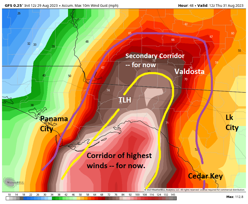
Another big change today has been the westward nudge likely putting Tallahassee in play for potential eyewall winds tomorrow morning as Idalia comes ashore. Using the GFS operational model as our guide, we can annotate roughly where the strongest winds *should* go at present.

A rough outline of where the strongest winds will be with Idalia: Not far from Tallahassee, perhaps stretching into Valdosta and much of South Georgia as well. This *could* shift around up to landfall. (Weather Bell)

Tallahassee is currently right on the edge of the stronger winds as Idalia comes ashore. This will probably be a close call between hurricane-force gusts and widespread hurricane-force winds with significant damage. Prepare accordingly. Anywhere that sees the strongest wind could see multi-day power outages.

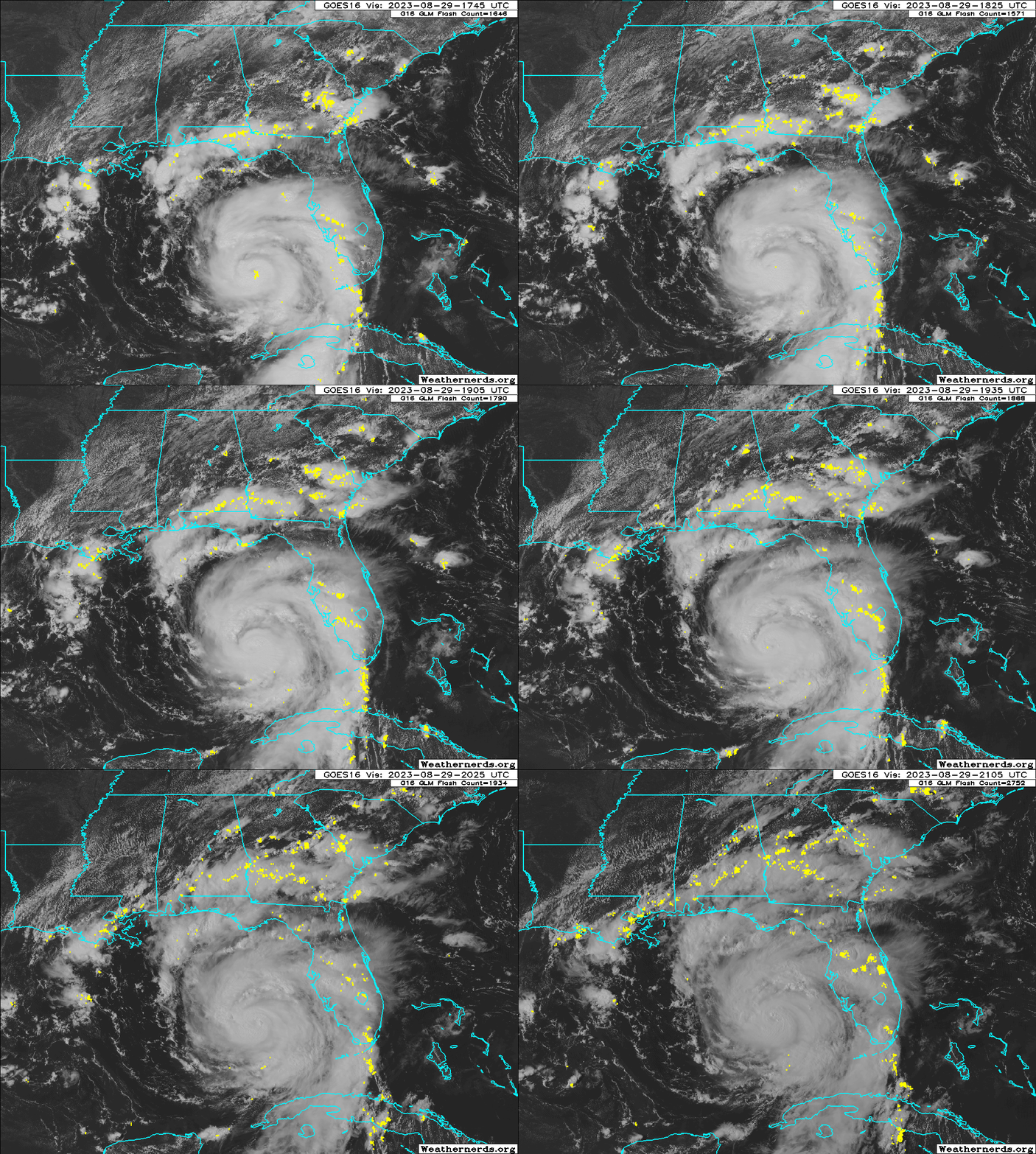
Hurricane Idalia is slowly taking on much better definition as it intensifies and it should use tonight to turn itself into a classic looking major hurricane by morning. (Weathernerds.org)

Other notes on Idalia in Florida and South Georgia

We discussed Tallahassee above. Tampa Bay will likely see 4 to 7 feet of surge and at least tropical storm force winds. This will cause serious flooding around the bay and along the coast. Please heed the advice of local officials tonight and tomorrow.

For interior and eastern Florida, this actually looks a bit less impactful now. We are seeing bands with isolated tornadoes and gusty winds. But for places like Orlando and Miami, it should not get too much worse. For Jacksonville, that area will see winds pick up tonight and tomorrow as Idalia passes by to the north and west. Wind impacts will be most significant west toward Lake City and north toward Waycross, GA and Brunswick, GA. Minor surge impacts are possible on the First Coast, with slightly higher surge impacts in Georgia (2 to 4 feet).

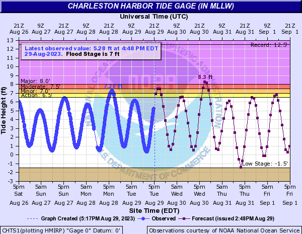
For Savannah moderate flooding is expected, but for Charleston, SC major flooding is forecast.

Major flooding is expected in Charleston due to Idalia’s surge. Rainfall may exacerbate things during Wednesday evening’s high tide. (NOAA)

Along the Georgia and South Carolina coasts, as well as near where Idalia comes ashore in Florida, water levels could be locally higher than forecast due to heavy rainfall as Idalia comes in, preventing water from being able to drain.

More on surge

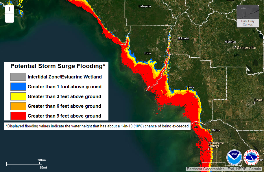
The amount of water that is expected to inundate portions of Citrus, Levy, Dixie, and Taylor Counties is catastrophic. The National Hurricane Center spends a lot of time deliberating when to use that word, but they chose it for this storm. Given that there is no modern history of a storm of this magnitude coming ashore in this area, there is no precedent for what is going to occur here. That’s a terrifying inundation map from this morning, which shows surge possibly going *well* inland from the coast in the Big Bend.

The inundation map for Idalia’s storm surge shows surge spreading well inland in the Big Bend. While the Big Bend is sparsely populated in Florida, for those communities, this will cause catastrophic damage. (NOAA)

The map above shows the scenario that has a 10% chance of being exceeded. This is somewhat of a worst-case scenario type map, but it gives you the right idea. You do not want to be on the coast or a few miles inland in the Big Bend. Surge impacts west of here will also be bad for Apalachee Bay, but less severe than this. Regardless, this is truly catastrophic surge coming to the Big Bend and east side of the bay.

Idalia’s exit

We still anticipate that Idalia will weaken to a tropical storm over Georgia and South Carolina, and it should exit the coast somewhere between Wilmington, NC and Savannah, GA depending on the exact track of the storm. From there, all bets are off in terms of track. We do expect wind shear to become a severe issue off the East Coast, so that should keep any reintensification of Idalia in check. I would not spend much time worrying over a second act of Idalia at this time. We’ll keep you posted. We’ll update once more later this evening and again in the morning. Look for a video update on our social channels this evening.

Editor’s Note:

I neglected to discuss rain before hitting publish. Here’s the latest rain forecast. Our late evening post will take a closer look at this.

Idalia’s Tuesday evening rainfall forecast (NOAA)
30 Aug 00:28

is this HR process for accommodations as bananas as it feels?

by Ask a Manager

This post was written by Alison Green and published on Ask a Manager.

A reader writes:

Like many companies, mine recently announced a tightening of hybrid/WFH scheduling. During the pandemic, I started an ongoing series of weekly healthcare appointments via telehealth, which have made a massive improvement in my life.

Until now, company policy was that people who are not client-facing could work from the office or from home at our discretion, subject to manager approval in the case of performance concerns. This makes telehealth appointments really easy! I have privacy, I can use a reliable hardwired internet connection to connect with my provider on my personal device, and there is no gap for travel between office and home — at the appointment time, I close my work laptop, open my home laptop, take the appointment, then turn right back to my work laptop and carry on. My boss does not care about me taking this time; I’m salaried and work well over 40 hours/week anyway, so one hour of the day, appropriately blocked off on my calendar, is no big deal.

Recently, our policy was refined to require a certain number of days in the office per week. Normally this would be fine with me — I prefer working in the office. But in certain circumstances (some recurring events I take PTO for a few times a year, and sometimes around holidays), I would be required to work in the office every other day of the week, including my appointment day.
I’ve tried taking my appointments in the office via my mobile phone, but it’s difficult to find privacy, the signal at the office is very poor, and my provider’s telehealth portal doesn’t play well with my phone. I could, I suppose, work in the office, then drive home for my appointment, and afterward drive back to the office. But this takes additional time out of my day, and also introduces additional risks (i.e., if I get caught in traffic and miss my appointment, incurring a missed appointment fee that insurance will not cover, as well as missing out on that week’s care). It would really be so much easier to just work from home one day a week, even if that’s the only day that week I work at all!

So I put in medical accommodation paperwork asking for a guaranteed WFH day to cover my medical care, with appropriate documentation from my provider. We are a Fortune 100 company and it seemed to me like it would be a simple and straightforward accommodations request.

Thus started the carnival of horrors.

A member of HR reached out to me to discuss my request. She then told me that this didn’t sound like her area and I needed to talk with our timekeeping segment of HR. So I called them and received a canned spiel about how I could qualify to give up my desk in the office altogether and work from home full-time. When I clarified that I was looking for a once a week accommodation, she referred me to yet another department of HR. This department heard my summary of what I’d been offered so far, then told me that if the first person had said it wasn’t her area, that sounded like I was being denied my medical accommodation and I would need to consult with an HR advocate. The advocate contacted me a day later, and gave me a condescending speech that boiled down to saying I should request FMLA to cover my healthcare appointments so they would be protected. He refused to engage with or address the question of whether FMLA would touch at all on my ability to work from home outside of the dedicated time away for my appointments. The other options he offered were to take an additional day of PTO for my appointment anytime it looked like I was going to fall afoul of policy, reschedule with my provider outside of working hours (those are also HER working hours!), or every compliance person’s favorite answer, “Don’t worry about it, exceptions can be made for occasional policy violations.” He refused to articulate for me if an exceptions policy was actually in place.

Is this bananas? This feels bananas! My understanding is that FMLA is about time NOT working, not accommodations to my working environment, and that being told the only answer the company can give me is “try for FMLA” is essentially a low-key way of telling me they are denying my accommodation request without any interactive process. I don’t know what’s going on anymore, just that I am trying to be a conscientious employee getting things in place before a problem arises, and apparently that is in fact how problems arise!

Yeah, this is a little bananas. FMLA isn’t the right solution here; as you note, it protects your job when you miss work and doesn’t cover things like work-from-home days. They’re missing the point: you’re not concerned about missing work, you’re asking for an accommodation to make medical appointments easier.

I think what you’re running into is probably that what you’re requesting isn’t something the law for medical accommodations would require them to offer. That law — the Americans with Disabilities Act (ADA) — would require that you be able to attend your appointments (assuming whatever you’re seeking treatment for falls under the ADA’s purview, but let’s assume it does) but not that you be able to do it in the easiest possible way. They’d be complying with the law just by ensuring you’re able to get the time off work for the appointments.

That might be why HR handled this the way they did … but if so, they’re communicating that badly.

Also, smart companies try to accommodate people even when they’re not strictly required to by law! If you have a compelling reason to have a protected work-from-home day each week (and it sounds like you do) and your boss is fine with that, they should at least think about formally accommodating that.

The fact that they’re not says either (a) they’re overly rigid and can’t assess situations outside of a strict legal framework or (b) company leadership has made it clear they want as few exceptions as possible to their return-to-office policies.

Any chance your boss can okay the arrangement you want informally? That’s not as ideal as having a written accommodation on file, but it might be a practical way to get what you want, at least some of the time.

30 Aug 00:16

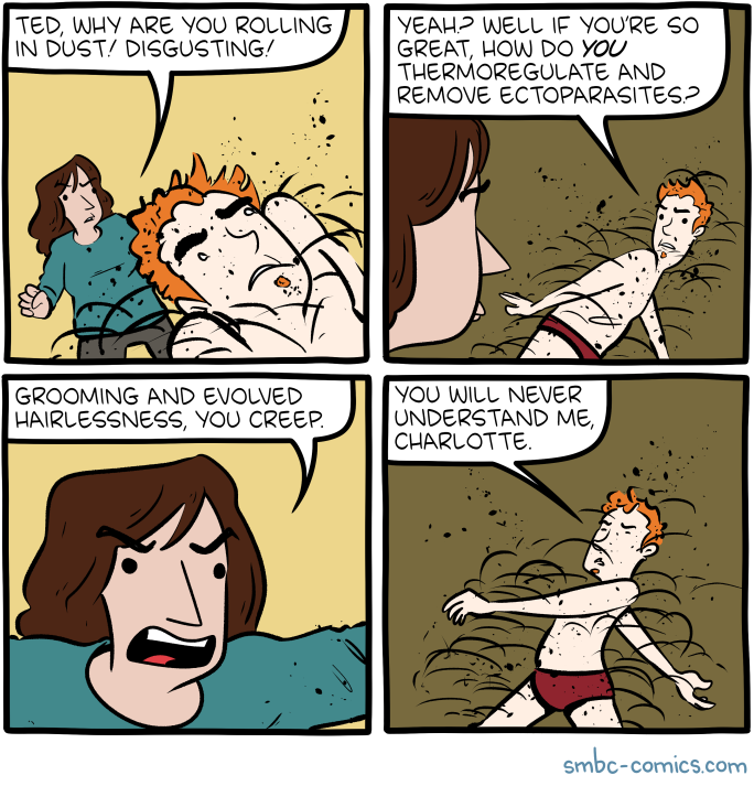
Saturday Morning Breakfast Cereal - Dust

by Zach Weinersmith


Click here to go see the bonus panel!

Hovertext:
So you'll eat a chicken that does this but you won't marry a HUMAN BEING who does? That's called hypocrisy.


Today's News:
30 Aug 00:15

companies that pay you to be a fraudulent hire at a different company

by Ask a Manager

This post was written by Alison Green and published on Ask a Manager.

Remember the saga last year where the person who showed up to do the job wasn’t the same person who interviewed for it? Wondering how they pulled that off?

A reader recently forwarded me an email her spouse received from a company whose entire business model seems to be that they’ll pay you to get fraudulently hired for jobs that you then (mostly) don’t actually work. Read on.

Hi [redacted],

Hope all is well with you. This is [redacted], the CEO of [redacted company name], a software development company based in Atlanta. Nowadays, we are receiving an overwhelming number of offers, and we are experiencing a lack of talented resources who can effectively communicate with clients.

We see that you are a developer with expertise that matches our needs. We are interested in offering you a non-stop ongoing contract, which is flexible based on your availability.

Your responsibilities will include taking calls with recruiters, HR managers, or teams before and after securing a job. You will be representing yourself on a call, and the actual development work will be delivered by [redacted company name]. We will be responsible for handling everything else and also assist you with every call.

Regarding compensation for you to speak on interviews (that we will assist you to pass), we will pay you on an hourly basis until we win a job. Once we secure a job, you will be expected to take a daily or a weekly scrum meeting, depending on their team culture. You will take the 25% of income from the job for taking these calls.

Given our ability to manage multiple jobs at once, if you handle calls for multiple jobs, this position offers you an exciting and stable income.

I am interested in speaking with you to discuss this partnership further.

Well then.

29 Aug 17:04

The popularity of DOS/4GW made Windows 95 game compatibility a little easier, but with higher stakes

by Raymond Chen

By far, the most popular so-called DOS Extender in the early 1990’s was DOS/4GW. MS-DOS game compatibility occupied a very large portion of my time during Windows 95 development, so I saw a lot of DOS Extender banners, most frequently the DOS/4GW banner.

Now, you might wonder, “How did these games even run in Windows 95 if they came with a DOS Extender? Wouldn’t the extender try to enter protected mode and fail, because Windows was already managing protected mode?”

The trick is that these extenders were really two programs bundled together. One was a protected mode server, and the other was a protected mode client library.

In the beginning, there was the Virtual Control Program Interface (VCPI), which was supported by expanded memory managers like EMM386. These expanded memory managers barely used protected mode at all: The only thing they cared about was getting access to memory above the 1MB boundary, so they set up some page tables in order to map extended memory into the expanded memory page frame, but did no other virtualization. MS-DOS ran in a virtual machine that had full hardware access, and the VCPI interface let an MS-DOS application say, “Hey, I’d like to take over complete control of the system now,” and VCPI would say “Sure, no problem!”

The VCPI interface quickly faded in popularity because no protected mode operating system (like Windows 3.0 in enhanced mode) would let any program take over complete control of the system. You would basically be suspending the old operating system in order to let the MS-DOS program take over as its own new custom operating system. Windows 3.0 introduced a new interface called the DOS Protected Mode Interface (DPMI) which let MS-DOS programs request that their code execute in protected mode, but only in user mode. The DPMI provider remained in control of kernel mode.

Okay, so back to DOS/4GW. When it started up, the DOS/4GW extender looked around to see if a DPMI server was already running. If not, then it installed itself as the DPMI server. But if a DPMI server was already running, then it allowed that DPMI server to remain in charge.

The game communicated only with the DPMI client portion of the library, which it used to transition to 32-bit mode, allocate memory, and do all those 32-bit things that these 32-bit game wanted to 32-bit do.

In other words, we have the following block diagram:

  Inside Windows       Standalone
DPMI server
(ring 0)
Windows       DOS/4GW
DPMI Server
       
DPMI client
(ring 3)
    DOS/4GW
DPMI Client
   
         
Game code
(ring 3)
    Game    

Both Windows and the DOS/4GW DPMI server implement the DPMI interface, so the DOS/4GW DPMI client used standard DPMI calls to communicate with both servers.

This was great for application compatibility, because if there was some issue with how the DOS/4GW client communicated with the DOS/4GW server, we just had to fix it once, and it fixed a lot of games. On the other hand, if the issue couldn’t be fixed, it broke a lot of games.

High risk, high reward.

Miraculously, most games just worked despite running under a different DPMI server from what they were originally developed with. There were occasional issues with specific games. Popular ones include games which assumed that all memory was physical and games which assumed the interrupt flag was unvirtualized, but for the most part, things worked well enough that the remaining issues could be treated as app-specific bugs.

The post The popularity of DOS/4GW made Windows 95 game compatibility a little easier, but with higher stakes appeared first on The Old New Thing.

29 Aug 16:58

Florida rushes to make its final preparations before Hurricane Idalia makes landfall

by Joe Hernandez
Adam Henderson, owner of Harbour Master Suites, prepares his business Tuesday in Cedar Key, Fla., ahead of the expected arrival of Hurricane Idalia.

Forecasters say Idalia will be at least a Category 3 hurricane by the time of its expected landfall on Wednesday. Officials are urging residents to get ready, and have ordered thousands to evacuate.

(Image credit: Rebecca Blackwell/AP)

29 Aug 16:57

Don’t look now, Houston, but August is almost over. Fall comes not today, but it likely is just weeks away

by Eric Berger

Today is August 29. There are just three days left in the month that I consider to be the worst of the year in Houston, weatherwise. August is consistently the hottest, most humid, and often the month with the worst drought conditions of the year in our region. That has unquestionably been the case this month, with record heat and, for most of the area, very little rainfall. And now it’s almost over. Good riddance.

Matt and I have a friendly debate about whether August or September is the worst month in Houston. His point is that, in the rest of the country, fall starts settling in in September, whereas in Houston we often see some of the warmest weeks of the year in September. While I understand Matt’s point, he is entirely wrong. At least in September we have the hope of seeing a bonafide cold front. Typically we see our first real front during the third or fourth week of the month. Hope may be a dangerous thing, but at least I have it in September.

Temperatures are slightly cooler this morning across the Houston region. (Weather Bell)

A cold front, by the way, is moving through the region today. Since it is August, however, this is an August front. Which is to say we’re going to see some drier air and (very) slightly cooler weather. This is not unwelcome, but it is not a front that will make you say, “ahhhh” either. Looking into the medium-term, there is no sign of a stronger front in the next 10 to 14 days, but rest assured it is coming. Probably within the next few weeks. We’re getting there, friends.

Tuesday

Thanks to the aforementioned front, high temperatures today will only top out in the mid- to upper-90s. With dew points dropping into the 60s, or even 50s further inland, this air will feel somewhat comfortable this afternoon for all areas but the immediate coast. Skies, otherwise, will be mostly sunny, with a northerly wind at 10 to 15 mph. Rain chances are effectively zero percent. Lows tonight will drop into the mid- to upper-70s for much of the area. The bottom line is that this evening should feel a bit more pleasant outside, especially as the Sun goes down.

Wednesday

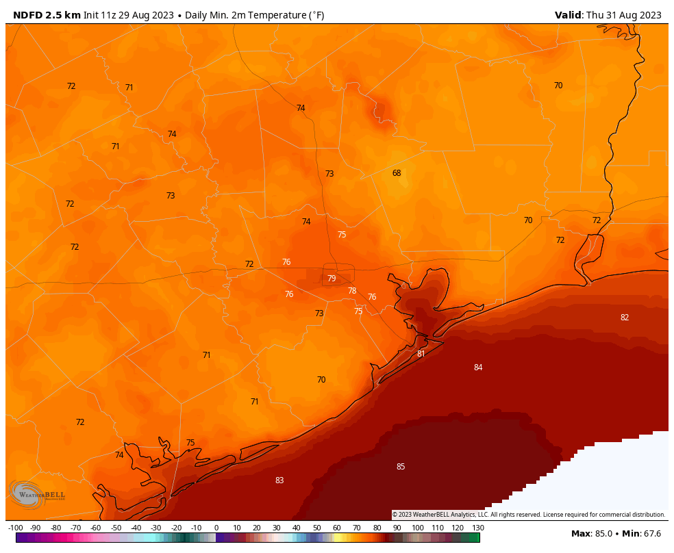
Dew points will bottom out on Wednesday. So although highs will push the upper 90s to 100 degrees, the air will again feel fairly comfortable during the daytime. Lows will drop into the 70s on Wednesday night, and a few areas far from the coast may even briefly touch the upper 60s. Enjoy this as a promise of what’s to come. The only downside is that we really, really need some rain, and none of that is in the cards before the weekend with the drier air.

A few areas could see lows in the upper 60s by Thursday morning. (Weather Bell)

Thursday and Friday

These will be days a lot like Wednesday, but we’re going to see dewpoints start to creep back up, so you’ll feel the humidity a little bit more each day. By Friday evening, I’m afraid, the front should be long gone.

Saturday and Sunday

Highs this weekend should be in the mid- to upper-90s with mostly sunny skies. Some inland areas will probably push 100 degrees. As moisture levels rise, we could see some rain showers kick up along the sea breeze during the afternoon or early evening hours, especially on Sunday. Rain chances are probably on the order of 20 to 40 percent each day, at least at this stage. Expect some refinement as we get closer to the weekend.

Next week

This pattern looks to more or less hold next week, with highs in the upper 90s for the most part, with low- to decent rain chances. See, September is already better than the 109-degree temperatures we were experiencing in August.

Forecast track for Hurricane Idalia. (National Hurricane Center)

Tropics

There’s likely to be a major hurricane in the Gulf of Mexico later today, Idalia. This storm presents a significant threat to the Gulf coast of Florida, particularly the Big Bend area of the state. We have full coverage of this storm, and the rest of the Atlantic tropics, on The Eyewall.

29 Aug 16:12

my coworker brought seven plus-one’s to a work party

by Ask a Manager

This post was written by Alison Green and published on Ask a Manager.

A reader writes:

I recently planned an office social hour at a local restaurant. My invite said “plus-ones are welcome, including kids, but please note you’ll be paying for your own guests.”

One coworker, Pam, brought her four kids, husband, mother-in-law, and nanny. Everyone else came alone or with one guest so, of the 19 of us at the event, eight were Pam’s family. Pam had to be there (she presented an award) and she paid for her family, but am I wrong in feeling that it was a social gaffe? Can/should I rephrase future invites to indicate that plus one means plus ONE?

This is an interesting twist on last month’s question from the polyamorous person who wanted to ask to bring both their partners to work events!

People normally know that “plus-one” means one unless they explicitly make other arrangements. However, I wonder if you inadvertently introduced ambiguity with the wording on your invitation: “plus-ones are welcome, including kids, but please note you’ll be paying for your own guests” contains a lot of plurals, and it’s possible that contributed to Pam reading it as “guests,” not “guest.”

Even then though … I think this is on Pam, not your invitation wording. She brought her mother-in-law and nanny to a work social hour? I could see bringing the kids along if she had no other child care for them, but that clearly wasn’t the case … and four kids, husband, mother-in-law, and nanny is a lot of additional guests for an event that otherwise had 11 people at it. When your guests make up 42% of the attendees at a work event, something is off. (It might be different if she were the one receiving the award — assuming it was a reasonably prestigious award and not, like, a Dundie — but she wasn’t.)

I’m curious whether Pam seemed to realize the mistake or whether it seemed just fine to her. It’s also possible there was some weird confluence of events that made it more convenient for her to bring everyone but which isn’t likely to be repeated.

In any case, normally you wouldn’t need to rephrase future invitations because this would normally not be a thing that would happen more than once. But since it did happen, in theory you could err on the side of more clarity in the future and write, “Plus-ones are welcome (one per employee)” or “(max of two per employee)” or whatever feels reasonable to you … but it’s not ideal because it means that if you’d normally welcome someone’s three kids but don’t want them dragging in-laws and nannies along, or if it would be fine for someone in a throuple to bring both their partners, this wording will potentially put up barriers you didn’t intend.

Realistically, I’d probably just wait to see if it happens again or not, and if it does then talk with Pam at that point … but otherwise assume people will generally get this right or at least mostly in the ballpark.

That said, normally I come down on the side of “if you have specific expectations in your head, be as clear as possible so people don’t have to guess.” In this case, though, it’s so unusual for “plus-one” to be interpreted as “plus-seven” that you don’t need to entirely change what you’re doing because of a single one-time outlier.

29 Aug 16:08

Clicking ‘Our Board Members’ Link Brings Up Whole Spread Of Shit-Eating Grins