Cowboy Who?
Shared posts
Study Finds Increased Cognitive Function Linked To Being Released From Headlock

ITHACA, NY—In a new study published Wednesday that offers fresh insight into the relationship between brain activity and the classic restraining maneuver, scientists at Cornell University’s Department of Neurobiology and Behavior found increased cognitive function is linked to being released from a headlock. “Subjects…
Archaeologists Find Marble Statue Of Ancient God In A Sewer

Bulgarian archaeologists excavating an ancient Roman sewer stumbled upon a 6.8-foot-tall marble statue of the Greek god Hermes, which they believe was intentionally placed there in 388 A.D. and covered with dirt, causing it to be remarkably well preserved. What do you think?
Megachurch Conducts Successful Nuclear Missile Test

LAKELAND, FL—In what the evangelical congregation hailed as a significant step forward for its security capabilities, local megachurch Lakeland Liberty Fellowship confirmed Tuesday it had conducted a successful test of a nuclear missile. “Today’s detonation of a 50-kiloton thermonuclear device should serve as a…
Quest To Find The Largest Number
You may have heard of some famous large numbers like Graham's Number or TREE(3) but I go way beyond that to find the largest number that could fit in a small space; an SMS text message or tweet.
Some googology and lambda examples from this video were hard to find, here are some resources to help if you're interested in researching further:
Lambda Diagrams: https://tromp.github.io/cl/diagrams.html
Binary Lambda Calculus: https://tromp.github.io/cl/Binary_lambda_calculus.html
Melo's Number: https://codegolf.stackexchange.com/a/263884
Buchholz Ordinal Algorithm: https://codegolf.stackexchange.com/a/219466
Check out 4D Golf on Steam: https://store.steampowered.com/app/2147950/4D_Golf
Other ways to support the channel:
Patreon: https://www.patreon.com/codeparade
Ko-fi: https://ko-fi.com/codeparade
Merch: https://crowdmade.com/collections/codeparade
Music CC by 4.0
Jesse Spillane - An Undersea Cache of Relics
https://freemusicarchive.org/music/Jesse_Spillane/the-big-idea-machine/an-undersea-cache-of-relics/
Caitlin Clark Supplements Rookie Salary By Taking Adjunct Professor Of Basketball Job

INDIANAPOLIS—Saying she figured she could do course prep while traveling to away games on the team bus, WNBA star Caitlin Clark told reporters she had begun supplementing her rookie salary this week with a second job as an adjunct professor of basketball. “I’m teaching a freshman-level Intro to Basketball Studies…
5 tips for acting like you know what you’re talking about while watching Canada-Argentina
It’s the biggest men’s soccer match in Canadian history tonight, as Canada takes on World Champions Argentina in the semi-finals of the Copa America. And that means thousands, possibly millions, of Canadians who know nothing about our team, its players or even the basic rules of the sport will be heading out to pubs or […]
The post 5 tips for acting like you know what you’re talking about while watching Canada-Argentina appeared first on The Beaverton.
Canada looks to break humiliating 106-year South American soccer championship drought
EAST RUTHERFORD, N.J. – The Canadian men’s national soccer team plays Argentina in the Copa America semi-final tonight, as Canada looks to end its pathetic century-long title drought in South America’s soccer championship. While top-ranked Argentina has won the Copa an impressive 15 times, Canada has never previously reached the semi-final, advanced out of the […]
The post Canada looks to break humiliating 106-year South American soccer championship drought appeared first on The Beaverton.
Comic for 2024.07.08 - Everybody
Comic for 2024.07.10 - Bend Over For Inspection
Saturday Morning Breakfast Cereal - Like that

Click here to go see the bonus panel!
Hovertext:
Trying to write more realistic dialog these days.
Today's News:
Bored Equifax Sees How Much They Can Lower Man’s Credit Score Before He Kills Himself

ATLANTA—Passing the time by inventing random things to penalize him for, bored officials at consumer credit reporting agency Equifax told reporters Tuesday they were seeing how far they could lower Danville, VA resident Scott Arkin’s credit score before he decided to kill himself. “It’s a slow day at the office, so we…
Biden Team Holds Rapid-Fire Series Of Public Events Featuring President Waving From Very Far Away

WASHINGTON—In an effort to combat escalating concerns about the commander-in-chief’s fitness for office, the Biden campaign kicked off a rapid-fire series of events Tuesday that featured the president waving from very far away. “President Biden wants to show voters he’s fired up and committed to this fight for the…
Locals Fire Water Pistols At Visitors During Barcelona’s Anti-Tourist Protests

Thousands of protesters in Barcelona attended a demonstration led by the Assemblea de Barris pel Decreixement Turístic (Neighborhood Assembly for Tourism Degrowth) to express their opposition to the number of visitors the city receives, with attendees spraying any tourists they saw with water guns. What do you think?
Awkward Zombie - Under Lock and Glee
Oh really? The Whataburger app begs to differ ...
Oh really? The Whataburger app begs to differ ...
Included in the sale is a basket of odd socks.

Included in the sale is a basket of odd socks.
Catholic Church Courts Youth By Adding Badass Deity With Robotic Falcon Head
LARPer With Food Allergies Ruining Sense Of Immersion

NEWTON, MA—Saying the role player’s peanut intolerance had pulled them entirely out of the fantasy experience, sources confirmed Monday that LARPer Gabe Collins’ food allergies were ruining their sense of immersion. “It’s obviously a serious condition, but it’s kind of hard to imagine myself as a chivalrous squire…
Tourist Visiting California Excited To Try One Of Those Vegetables He’s Heard So Much About

SAN FRANCISCO—Claiming they didn’t have anything like it back home, tourist Greg Foskey told reporters during his trip to California this week that he was excited to try one of those vegetables he’d heard so much about. “Whenever you mention California, people always bring up the vegetables, and I want to see what…
Tearful Boston Dynamics Engineer Forced To Drown Unwanted Robot Puppies

WALTHAM, MA—Heeding his supervisor’s order to get rid of the excess newborn mechanical quadrupeds, tearful Boston Dynamics engineer Leon Rosoff was forced Monday to drown several unwanted robot puppies. “I’m so sorry, little robofellas, but we don’t have the funding to maintain all of you,” said a sniffling Rosoff,…
Highlights From The Heritage Foundation’s ‘Project 2025’

Several high-ranking members of Donald Trump’s former administration recently released a stunning, highly detailed document outlining how they would overhaul the federal government should he be reelected president. The following are the biggest takeaways from the Heritage Foundation’s 922-page political playbook…
Liberal Party watches in horror as French centrists fail to turn fear of right-wing maniacs into unending political power for themselves
OTTAWA – High ranking members of Canada’s Liberal Party were shocked and dismayed by the results of the French election, with Trudeau in particular unable to fathom that Macron’s centrist coalition wasn’t able to scare their way into remaining in power. “I don’t understand this, people in France were terrified of the fascists winning,” Trudeau […]
The post Liberal Party watches in horror as French centrists fail to turn fear of right-wing maniacs into unending political power for themselves appeared first on The Beaverton.
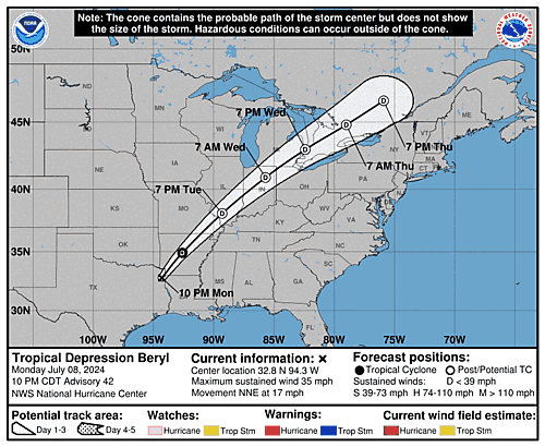
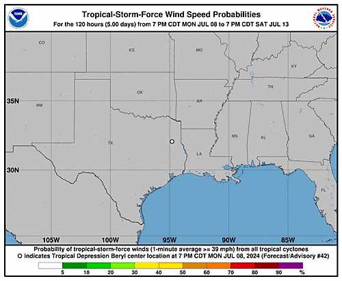
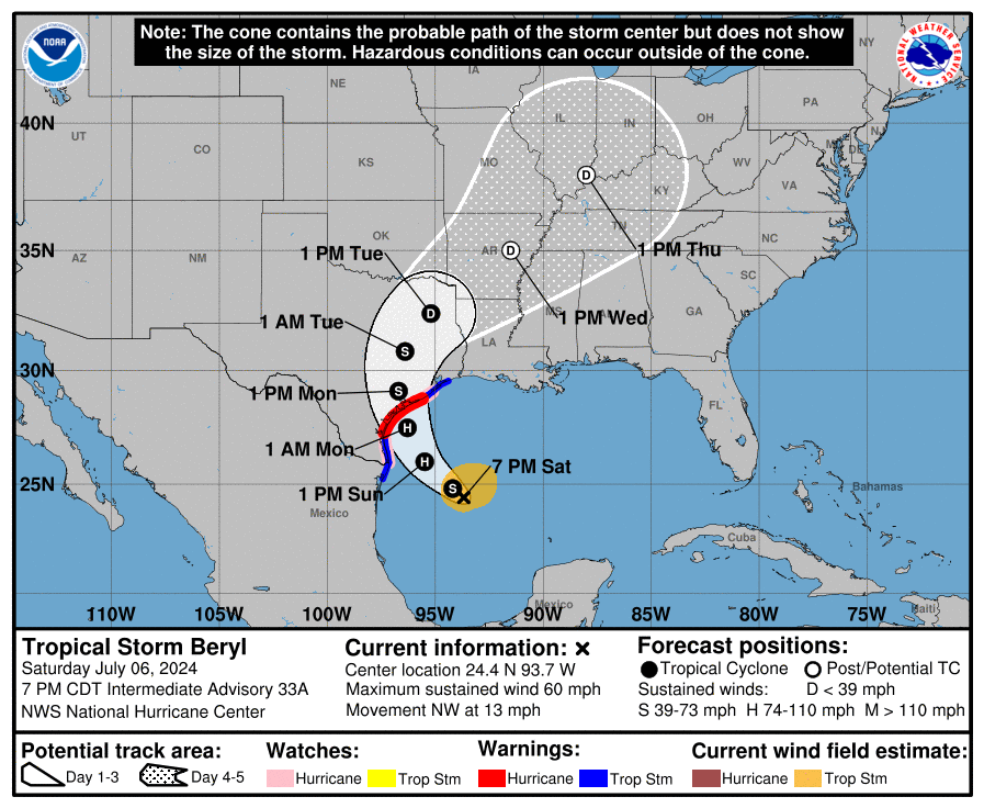
Tropical Storm Beryl Graphics
French voters reject the far-right
French voters turned out in numbers not seen in decades to stop the far-right National Rally from taking power in the French National Assembly.
Beryl will bring damaging winds, heavy rain into Houston area beginning tonight
In brief: So far Beryl hasn’t strengthened much today, but there is yet time for intensification before a final landfall tonight. This post goes into the likelihood of such intensification and what it would mean for Houston in terms of winds and the potential for power outages. We also look at the latest rain and surge forecasts.
Beryl status at 4 pm CT
As of this afternoon Beryl remains a tropical storm with 65 mph winds. Its central pressure has dropped a bit to 988 mb, indication a trend toward better organization. The storm is moving to the north-northwest at 12 mph and remains on course to make landfall near Matagorda between midnight and 4 am CT on Monday.
Intensity and track outlook
The fact that we’re not seeing significant increases in Beryl’s winds this afternoon is great news. The biggest threat to the greater Houston area from Beryl is damaging winds, and less intensification means less damage once onshore.
Beryl is running out of time to strengthen—that is not a taunt, mind you. Please let the record show I did not taunt Beryl. The storm will move inland in 8 to 12 hours. There is still time, and the waters are very warm with atmospheric shear low. However, forecasters at the National Hurricane Center note the storm is still struggling to shrug off some dry air in its core. They are still calling for an 85-mph, Category 1 hurricane at landfall, with the likelihood of rapid intensification this evening. This certainly seems plausible, but I am rooting for that dry air to keep disrupting things for just a little while longer.
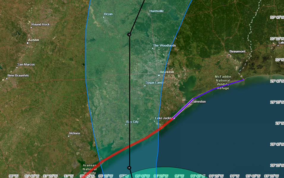
In terms of track there is very little change to the system. Beryl should come ashore early on Monday, and pass near Katy a little before noon before it lifts further out of the Houston area. This rapid forward movement should continue, allowing the worst effects to begin clearing out of the city during the afternoon hours.
What to expect, and when to expect it
Tropical-storm force winds should reach the coast, near Matagorda Bay, around sunset on Sunday and push into Galveston Island a few hours later. The stronger winds will move into much of the rest of the metro area just before or after midnight tonight. The heaviest rains will arrive around the same time. Please find shelter a few hours before this.
How bad will the winds get?
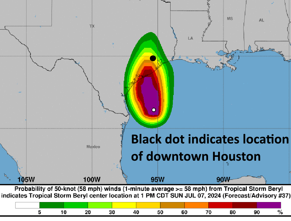
For this outlook I am going to focus on the possibility of seeing sustained winds of 60 mph or greater, which is likely near the threshold for widespread power outages. The map below shows the National Hurricane Center forecast for the probability of winds of 58 mph or greater from Beryl. I’ve annotated it with circle that roughly denotes Loop 610. Winds at this speed likely will not cause roof damage (that threshold is higher, perhaps 70 to 90 mph sustained winds). The map clearly shows the risk for damaging winds and power outages is greatest to the southwest of Houston:
Several readers have asked about tornadoes. Yes, they’re possible within the rainbands of Beryl tonight and on Monday morning. However I expect their development to be fairly scattered, and the bigger threat for a majority of people will be winds directly related to Beryl’s circulation.
Some thoughts on power outages
I’ve spent a couple of hours today doing some digging to try and set some expectations for power outages tonight and later on Monday as the core of Beryl’s winds move into the greater Houston area. Our most recent tropical system with a major “wind” component was Hurricane Ike, a Category 2 storm that made landfall in 2008. It came ashore about 90 miles further east than where we expect Beryl, but it was a much larger and more powerful hurricane. Here is what Ike’s sustained winds looked like.
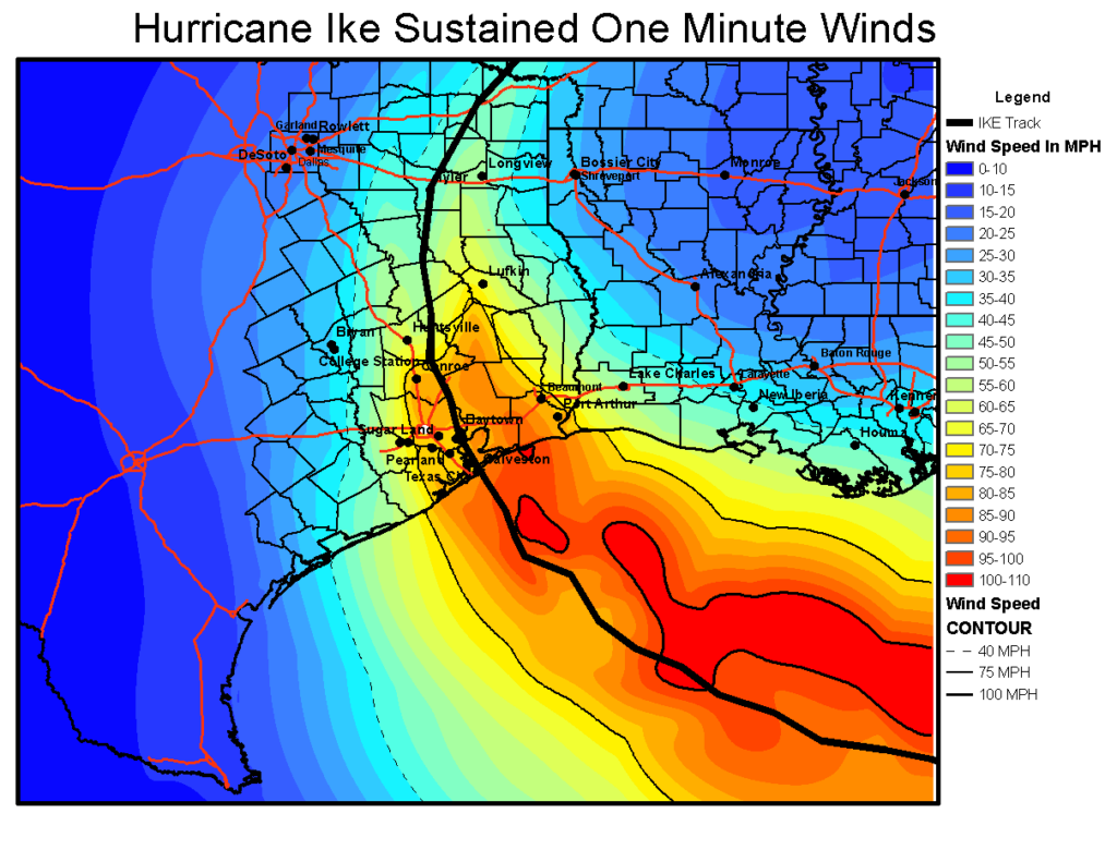
Ike knocked out power to 2.1 million CenterPoint Energy customers in Houston, and 10 days later the power remained out for about one-third of these customers. I want to be clear, I do not think Beryl will have this magnitude of an effect. Far from it, likely. But it’s useful to study the map of outages below and see where there were fewer problems (i.e. northwest Houston).
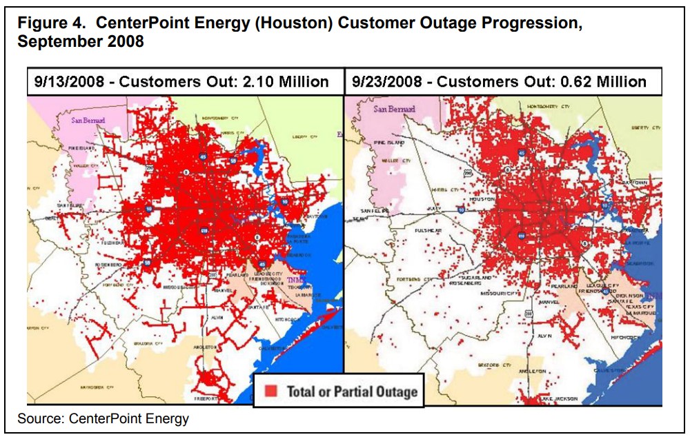
My back-of-the-envelope estimate here is that widespread power outages start to become more likely at sustained wind speeds of about 60 mph. The majority of Houston will probably less than this tonight, although such winds are likely in many areas of Brazoria, Fort Bend, and Matagorda counties. They are also possible west of Houston, in locations such as Katy.
My general expectation, therefore, is that power losses will be in the hundreds of thousands, and restorations in days; rather that losses above 1 million with a week or two of restoration. However that is a guess rather than a firm conviction, and given since so many people are understandably concerned about this issue.
Finally, I very much do not expect hurricane-force sustained winds tonight in any part of the Houston metro area apart from the immediate coast near Matagorda, and possibly locations such as Freeport or Lake Jackson. For what it’s worth, CenterPoint’s estimate for Category 1 winds is: “extensive damage to power lines and poles likely will result in power outages that could last a few to several days.”
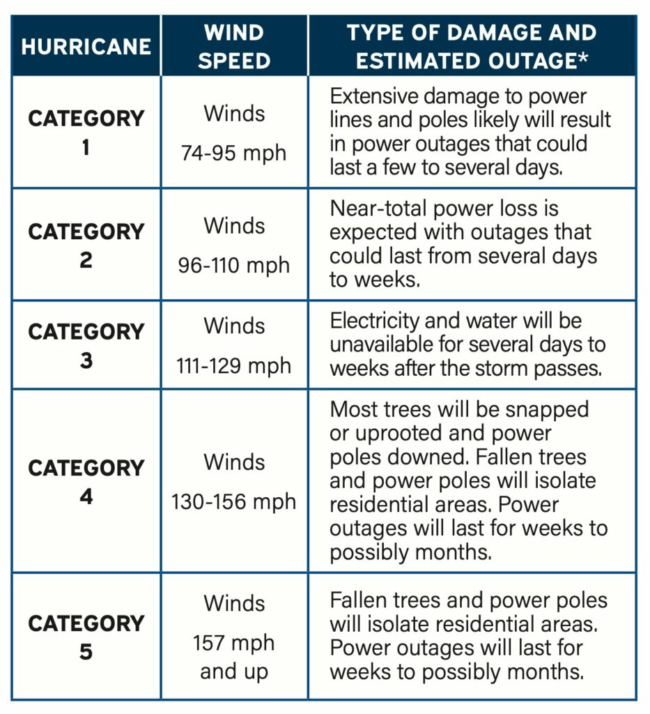
The bottom line is that power outages will be a wait-and-see game. Good luck. Charge those phones now, my friends.
Let’s talk rainfall totals
We’ve seen some fairly widespread shower and thunderstorm activity today as Beryl’s outer rainbands have moved onshore. So far, it’s been fine. I expect to see additional storms this afternoon and evening, but it should be mostly manageable.
The main event should arrive at the coast a few hours before midnight, and push into Houston around midnight. Based on the latest modeling the “thickest” rain band will likely move through the city around 4 to 8 am, bringing intense rains that will quickly flood streets. Conditions should start to improve during the late morning hours. However I would expect to see additional rain showers later on Monday night and Tuesday due to trailing bands (which won’t be as intense). In any case, this is another good reason to stay home from this evening through Monday morning.
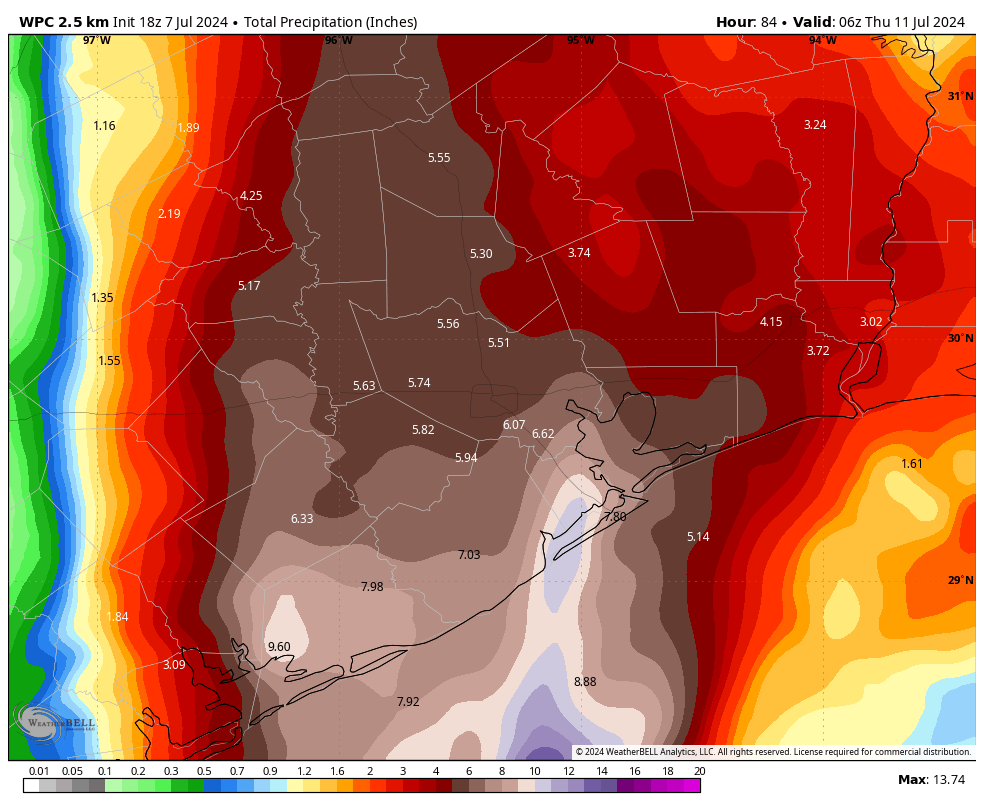
In terms of accumulations, it still looks like coastal areas face the highest risk, with totals of 5 to 10 inches likely, and accumulations further inland of perhaps 4 to 8 inches. What we’re most concerned about are more isolated areas that fall under the heaviest banding. These locations could see 10 or more inches of rainfall. It is impossible to predict precisely where these will set up, but the latest modeling is hinting at higher totals near Galveston Bay. We’ll see. We have a Stage 2 flood alert in place.
Storm surge
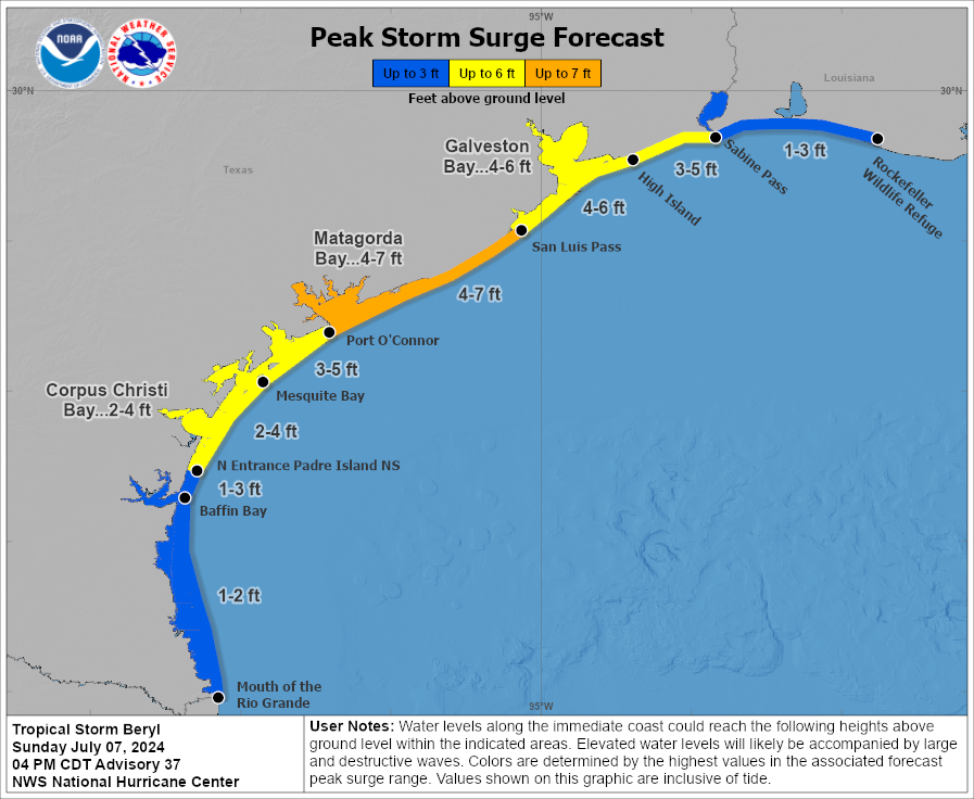
Peak storm surge levels, the combination of high tide and surge, should arrive on Monday morning the upper Texas coast. For Galveston Island and Galveston Bay, water levels are expected to be 4 to 6 feet above normal levels. Surge should be slightly higher in Matagorda Bay.
Final thoughts and plans for tonight
Beryl is on our doorstep, and its winds, rains, and waves will move into our area tonight. The key thing I’m watching over the next several hours is whether the storm starts intensifying, as a weaker Beryl will cause far fewer problems in Houston on Monday morning. As always, we will hope for the best and prepare for the worst. Please make plans to get home, or to a safe place this evening, and remain there through the morning hours on Monday.
Our next post will come around 10:30 pm CT tonight, and we’ll continue to post overnight and into Monday as this dynamic event develops.
Beryl’s not quite ready for a second wind but intensification is likely once more tomorrow leading up to Texas landfall
Headlines
- Beryl on track for a middle Texas coast landfall on Monday.
- Hurricane Warnings posted from Baffin Bay north through Sargent.
- Flood Watches issued for much of coastal Texas and just inland.
- Beryl did not organize much more today, but it continues to look likely to intensify again tomorrow, particularly in the last few hours leading up to landfall.
Tropical Storm Beryl (60 mph, NW 13 mph)
As expected, despite the burst of storms within Beryl’s circulation today, it failed to translate to any real serious organization or strengthening, and for all intents and purposes Beryl is mostly status quo since this morning.
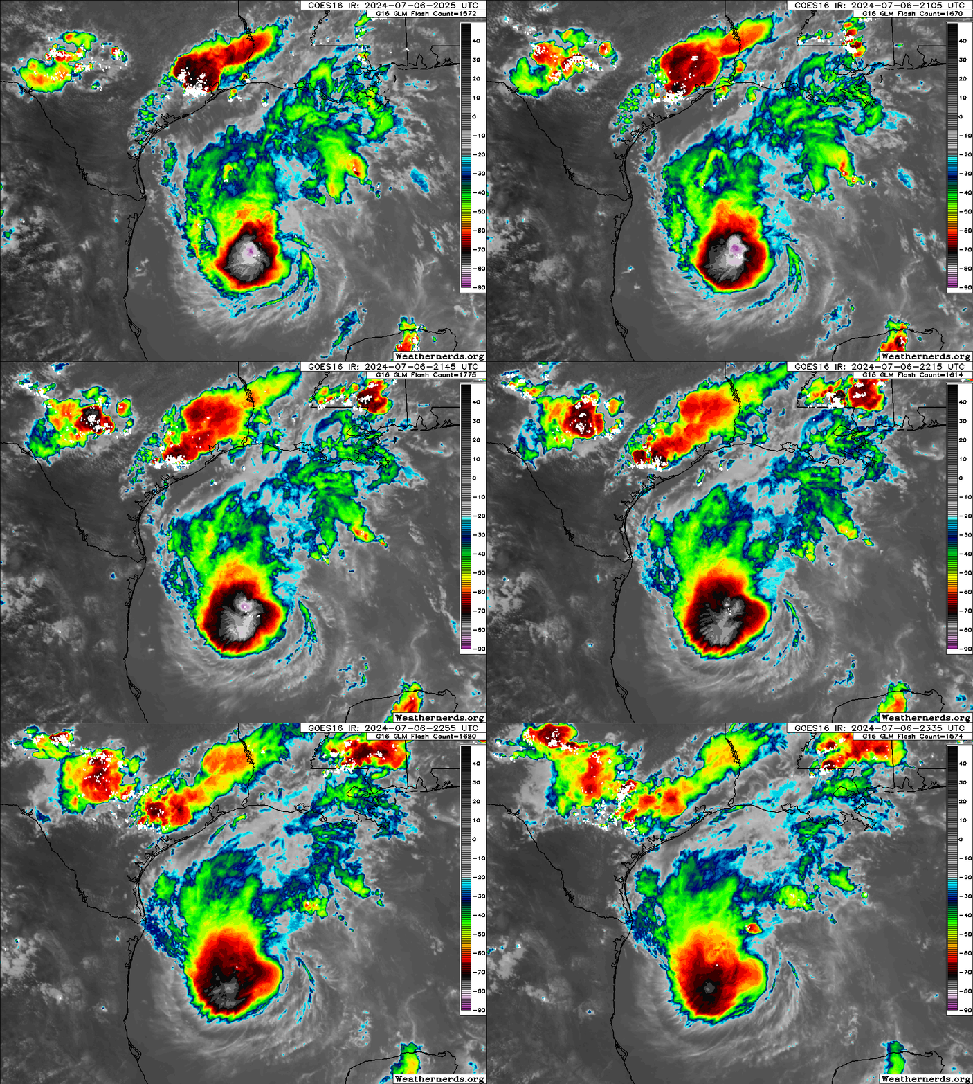
This was expected for the most part, and we continue to expect that Beryl will improve its environment tomorrow leading to a period of slow then possibly rapid intensification up to landfall in Texas. We are likely looking at a landfall in the morning hours Monday. The current NHC forecast is in line with most model guidance, showing a middle to higher-end category 1 storm at landfall. That being said, a couple usually reliable models do show Beryl with potential to become a category 2 storm with 100 mph winds at landfall. Do not be lulled to sleep by the lack of intensification today. This was what had been anticipated.
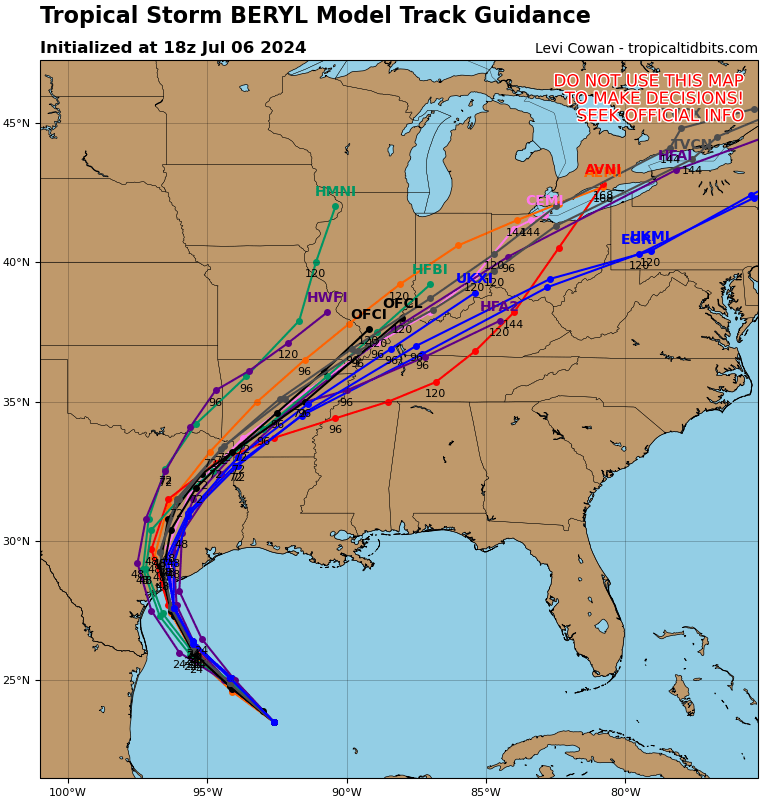
Where will that landfall occur? Again, impacts will spread out from the storm, but for the strongest wind and surge, that landfall point is important. We have seen little movement in the modeling today with the bounds between about Sargent, TX through Corpus Christi Bay looking most likely to see the ultimate landfall of Beryl. I think the risk is probably skewed more to the right half of that spread, somewhere near Matagorda Bay. The risk drops east of there toward Galveston (albeit not quite zero) and west of Corpus Christi. Hurricane Warnings are posted from Baffin Bay through Sargent. I would again say that the risk is highest in the eastern half of that warning spread, but folks in Corpus Christi should continue to finalize any preparations they’ll be implementing.
Let’s talk a little more about some of the impacts from Beryl beyond wind.
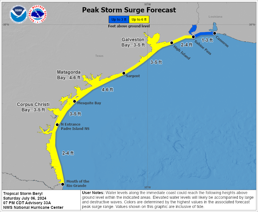
Storm surge will be a serious concern in the Matagorda Bay region, and water levels of 4 to 6 feet above normally dry ground are expected. This will be at least a couple feet higher than experienced than last month in Alberto. From San Luis Pass through High Island, the storm surge will be similar to what was experienced during Alberto, and for Cameron Parish, LA it will be similar or lower than what was seen during Alberto. Heed the advice of local officials in terms of evacuation orders or other preparations at the coast. This storm is likely to come in stronger than Hurricane Nicholas in 2021, the most recent direct hit in this area.
Power outages are likely to be widespread in the Matagorda Bay region of Texas. Isolated to scattered power outages may impact the Coastal Bend or the coast up through Brazoria County, including Freeport, Lake Jackson, or Galveston. Additional isolated to scattered power outages may impact the greater Houston area’s south or west side, including heavily populated Fort Bend County depending on the exact track and speed of Beryl.
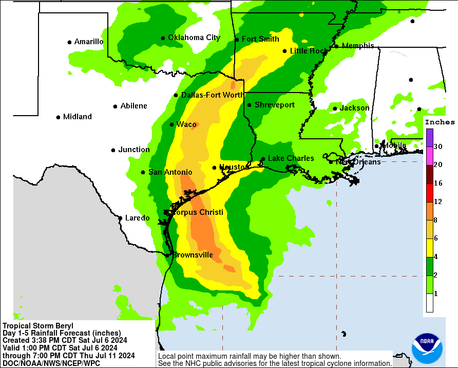
Rainfall is another issue with Beryl. The good news is that Beryl will not stall or do weird loops over Houston and southeast Texas. The bad news is that Beryl will be moisture-laden and able to produce a period or a couple periods of torrential rainfall Monday. The current forecasts with Beryl’s track shows a narrow corridor of very hefty rain totals along and just east of the center. The exact track will determine who gets 4 to 6 inches of rain or who gets 8 inches of rain or more. For urban areas like Houston, this will be a critical threshold in terms of minor to moderate flash flooding versus something more serious. Current rain forecasts pinpoint Wharton through College Station up north to near Tyler and east of Dallas for the heaviest rainfall. Look for more on this tomorrow.
As is the case with most landfalling tropical systems, isolated tornadoes will be a possibility on Sunday night or Monday as Beryl comes ashore. This would be primarily east of where the center comes ashore, including the Houston and Galveston areas, possibly as far east as Beaumont or Port Arthur. Expect several tornado warnings on Monday with a handful of possible tornadoes.
We will have the latest for you in the morning after we see what Beryl does tonight.


