French voters turned out in numbers not seen in decades to stop the far-right National Rally from taking power in the French National Assembly.
Cowboy Who?
Shared posts
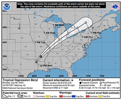
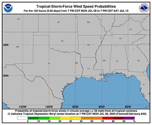
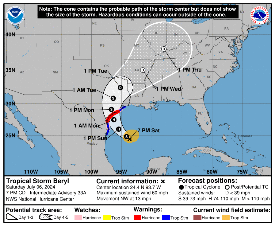
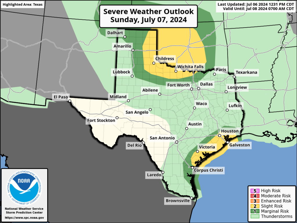
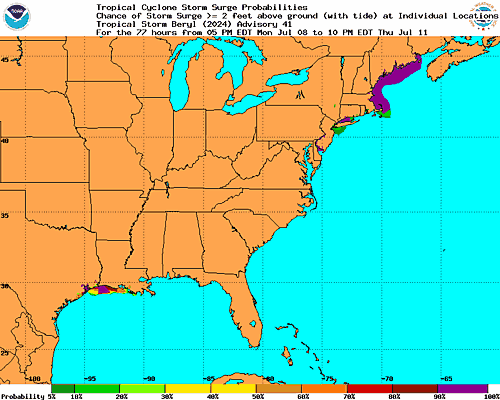
Tropical Storm Beryl Graphics
'Our pandemic in Canada': Grandmothers step up to raise children orphaned by premature deaths

As crystal meth and opioids claim lives throughout Canada, some grandparents are stepping up to raise the grandkids left behind.
French election sees leftist gains, far-right slide and a hung parliament

Ukraine's Yaroslava Mahuchikh breaks decades-old world record in women's high jump

Two world records fell at the Diamond League track and field meeting in Paris on Sunday. Yaroslava Mahuchikh of Ukraine erased a mark that stood for 37 years in the women's high jump, while Kenya's Faith Kipyegon bettered her own world record in the women's 1,500 metres.
Beryl’s not quite ready for a second wind but intensification is likely once more tomorrow leading up to Texas landfall
Headlines
- Beryl on track for a middle Texas coast landfall on Monday.
- Hurricane Warnings posted from Baffin Bay north through Sargent.
- Flood Watches issued for much of coastal Texas and just inland.
- Beryl did not organize much more today, but it continues to look likely to intensify again tomorrow, particularly in the last few hours leading up to landfall.
Tropical Storm Beryl (60 mph, NW 13 mph)
As expected, despite the burst of storms within Beryl’s circulation today, it failed to translate to any real serious organization or strengthening, and for all intents and purposes Beryl is mostly status quo since this morning.
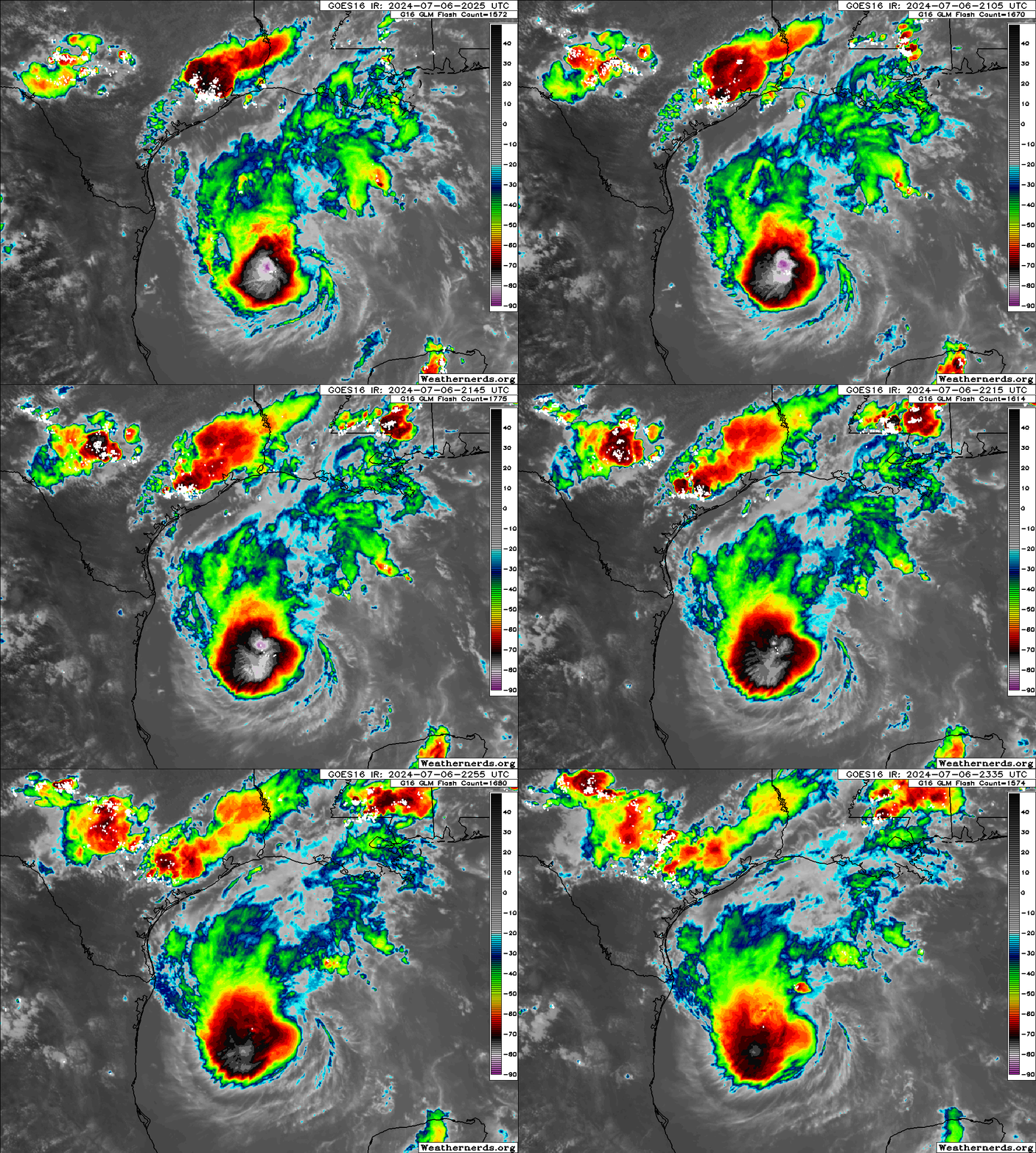
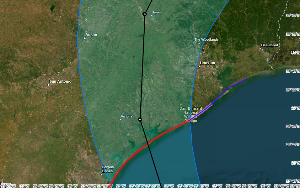
This was expected for the most part, and we continue to expect that Beryl will improve its environment tomorrow leading to a period of slow then possibly rapid intensification up to landfall in Texas. We are likely looking at a landfall in the morning hours Monday. The current NHC forecast is in line with most model guidance, showing a middle to higher-end category 1 storm at landfall. That being said, a couple usually reliable models do show Beryl with potential to become a category 2 storm with 100 mph winds at landfall. Do not be lulled to sleep by the lack of intensification today. This was what had been anticipated.
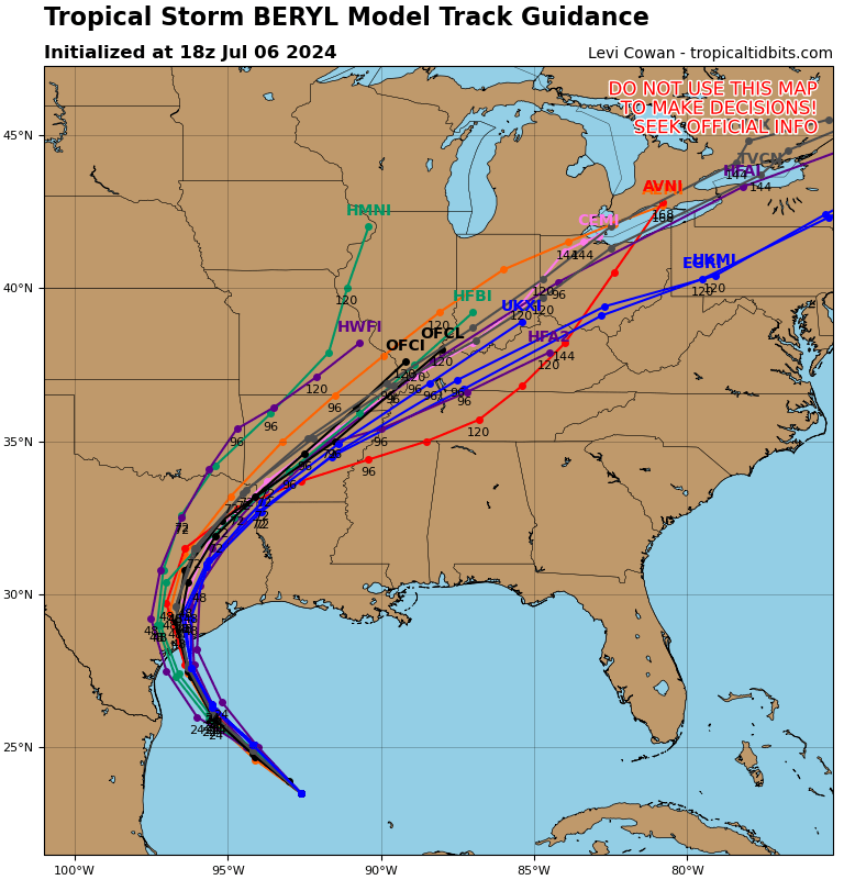
Where will that landfall occur? Again, impacts will spread out from the storm, but for the strongest wind and surge, that landfall point is important. We have seen little movement in the modeling today with the bounds between about Sargent, TX through Corpus Christi Bay looking most likely to see the ultimate landfall of Beryl. I think the risk is probably skewed more to the right half of that spread, somewhere near Matagorda Bay. The risk drops east of there toward Galveston (albeit not quite zero) and west of Corpus Christi. Hurricane Warnings are posted from Baffin Bay through Sargent. I would again say that the risk is highest in the eastern half of that warning spread, but folks in Corpus Christi should continue to finalize any preparations they’ll be implementing.
Let’s talk a little more about some of the impacts from Beryl beyond wind.
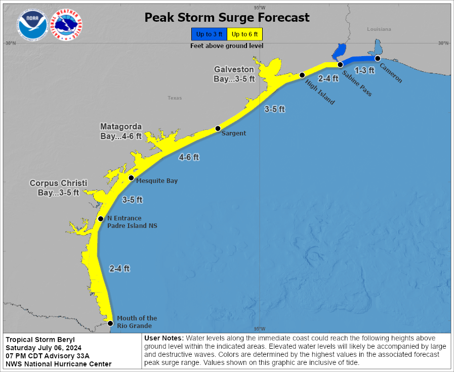
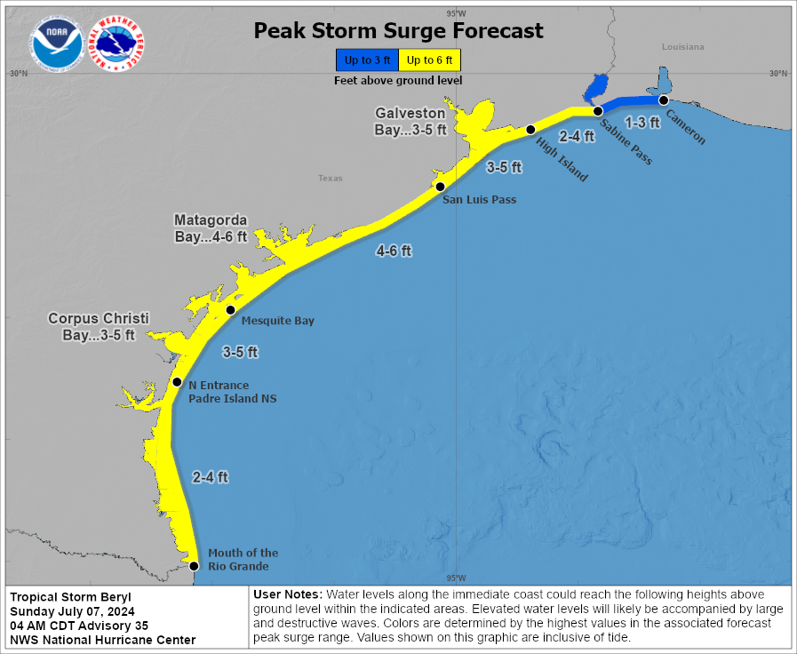
Storm surge will be a serious concern in the Matagorda Bay region, and water levels of 4 to 6 feet above normally dry ground are expected. This will be at least a couple feet higher than experienced than last month in Alberto. From San Luis Pass through High Island, the storm surge will be similar to what was experienced during Alberto, and for Cameron Parish, LA it will be similar or lower than what was seen during Alberto. Heed the advice of local officials in terms of evacuation orders or other preparations at the coast. This storm is likely to come in stronger than Hurricane Nicholas in 2021, the most recent direct hit in this area.
Power outages are likely to be widespread in the Matagorda Bay region of Texas. Isolated to scattered power outages may impact the Coastal Bend or the coast up through Brazoria County, including Freeport, Lake Jackson, or Galveston. Additional isolated to scattered power outages may impact the greater Houston area’s south or west side, including heavily populated Fort Bend County depending on the exact track and speed of Beryl.
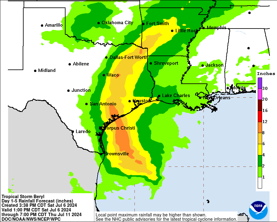
Rainfall is another issue with Beryl. The good news is that Beryl will not stall or do weird loops over Houston and southeast Texas. The bad news is that Beryl will be moisture-laden and able to produce a period or a couple periods of torrential rainfall Monday. The current forecasts with Beryl’s track shows a narrow corridor of very hefty rain totals along and just east of the center. The exact track will determine who gets 4 to 6 inches of rain or who gets 8 inches of rain or more. For urban areas like Houston, this will be a critical threshold in terms of minor to moderate flash flooding versus something more serious. Current rain forecasts pinpoint Wharton through College Station up north to near Tyler and east of Dallas for the heaviest rainfall. Look for more on this tomorrow.
As is the case with most landfalling tropical systems, isolated tornadoes will be a possibility on Sunday night or Monday as Beryl comes ashore. This would be primarily east of where the center comes ashore, including the Houston and Galveston areas, possibly as far east as Beaumont or Port Arthur. Expect several tornado warnings on Monday with a handful of possible tornadoes.
We will have the latest for you in the morning after we see what Beryl does tonight.
Want to know what a storm is likely to do where you are? Dig into your phone’s weather app
In brief: We’re happy to have Dwight Silverman, a longtime Houston tech journalist who is working with us behind the scenes, contribute this post on how to find hyper-local forecast information from the powerful computer in your pocket. Dwight explores some features and data in your phone’s weather apps you may not know existed.
Whenever a storm is bearing down on the Houston area, Eric and Matt are swamped with questions about conditions at individual readers’ locations. They have time to answer a few of them, but given what needs to be done and the volume of work they face, they can’t respond to all of these queries.
But there’s good news: Often, the answers you seek can be found in the palm of your hand.
Nearly everyone carries a smartphone, and many weather apps that are included with them can give you a lot more detail than just the current temperature and rain chances. Some let you drill deep into the metrics you want to know most about a major storm – wind speed and precipitation. Want to know what peak wind gusts will be when a storm is forecast to be nearest you? Or how much rain is expected to fall near you? There is, indeed, an app for that. They’re not perfect, and they don’t do a great job with uncertainty in forecasts, but they offer a solid approximation of what to expect.
This post is not intended to be a manual for weather apps, but rather to shed some light on features you may not realize are there, or are hidden a few layers deep in an app’s design. There are many third party weather apps out there, and I am not going to try to cover them all. But I will offer tips for some of the better one, and those that are included on your phone.
Space City Weather
You may have heard that we have our very own, free app? It’s true, and it’s available for both Apple products (iPhones, iPads, Macs) and Android devices. The app is primarily designed to give you quick access to Eric’s and Matt’s posts, current conditions, hourly and daily forecasts for a week out, as well as radar for any of 12 cities in our region. But one thing you may not realize is that it includes detailed, up-to-date National Weather Service forecasts and advisories on storms and hazardous conditions.
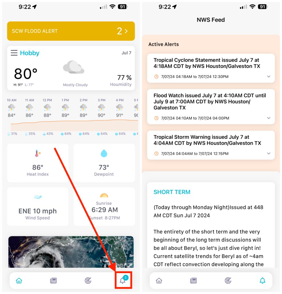
Open the SCW app, tap the bell icon in the lower right corner of the screen to get to the Active Alerters as well as short- and long-term advisories. There are also discussions of aviation and marine weather as you scroll down. (Note: The aviation section will NOT tell if your flight has been canceled! Check with your airline, and keep an eye on the FAA’s airport status website.)
Apple Weather
After Apple bought the popular Dark Sky app, it soon redesigned the app that came with iPhones, iPads and Macs to incorporate the former’s hyperlocal forecast features. It will give you details about conditions – both current and future – at relatively precise locations.
However, this integration has been, umm, less than smooth. For example, last year the app was not loading data, and in other instances it was forecasting rain when there was none. The patient seems to have stabilized lately, but it’s a good idea to double-check what you see in Apple’s Weather app with other sources. (You can find where Apple gets its weather data here.)
That said, the app makes it easy to see forecasts for specifc conditions, particularly wind and precipitation, at your location. On the iPhone, iPad and Mac, it shows you conditions in individual tiles, and tapping any of them takes you to a screen that lets you move forward in time to check the the forecast for a specific condition.
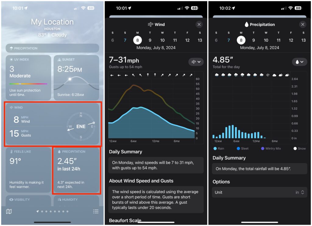
For example, if you scroll down on the iPhone to the Wind or Precipitation tiles and tap one, you’ll get the current conditions for the day in a chart. Scroll to the left to move to the next day, or tap the calendar date near the top.
Traveling and want conditions and forecasts for a different location? Enter the ZIP code in the search field. You can save any of the locations for future use. You’ll also see forecast alerts, warnings and advisories for those locations.
Android devices
Unlike Apple devices, which all have the same detailed Weather app, Android smartphones and tablets use different apps and services, depending on who makes the hardware. For example, Google’s Pixel phones use Google’s own weather service for much of its onscreen information, while Samsung and OnePlus phones will kick you out to a weather website, typically Weather.com.
But there is a general strategy you can use: In the five- or seven-day forecast list, choose the day you want to explore and tap it, then look for the metric – wind or precipitation – for the target location.
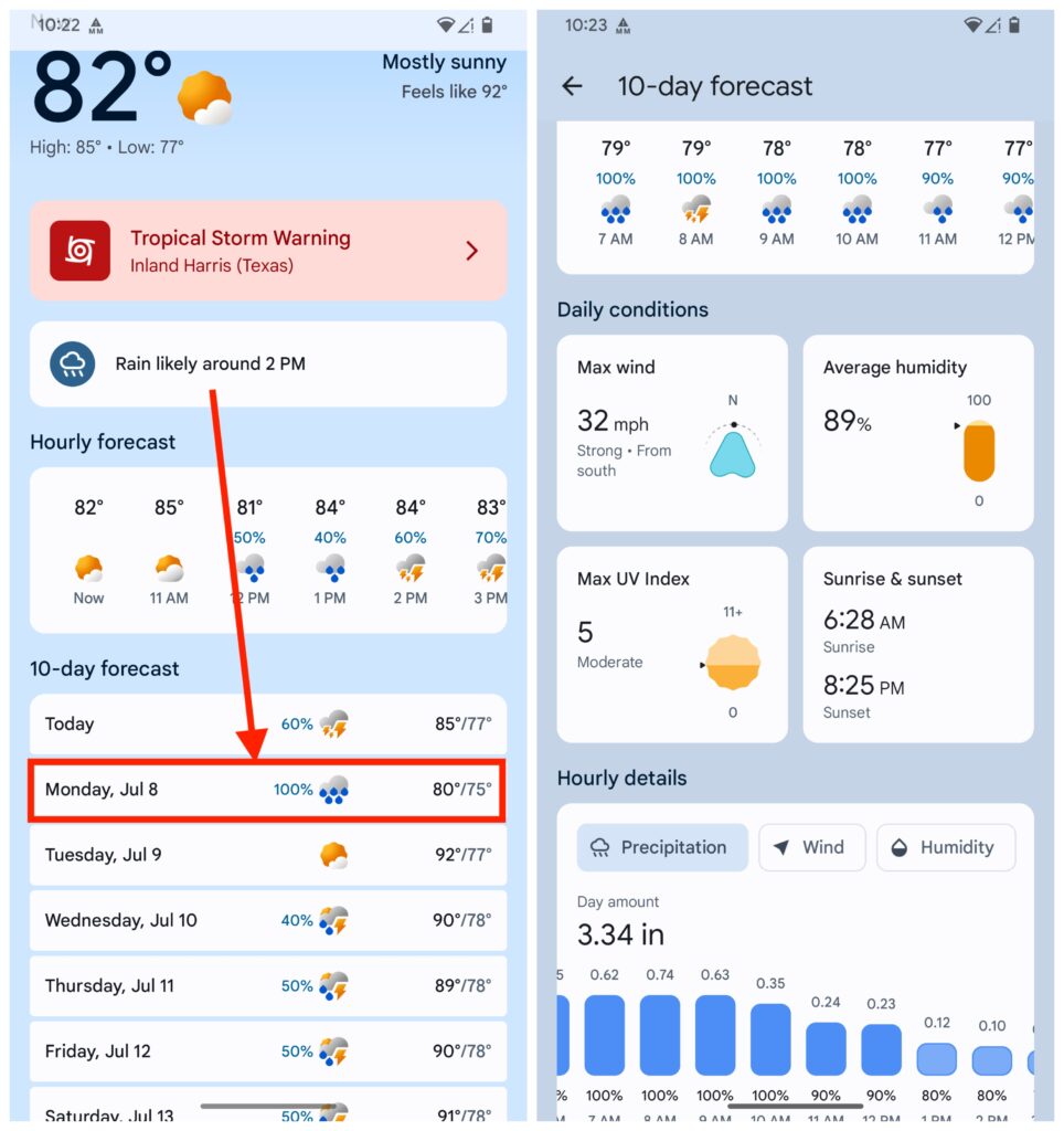
In the image above, tapping on the weather widget that’s the default on a Pixel phone’s home screen, you’re taken to a general weather page. From there, tap the day for which you want details, and scroll down for wind and precipitation forecasts for that day.
Experiment with the app on your Android phone to find the best route to the information you need.
Next, let’s look at a couple of third-party apps that, while not free for all features, may be well worth buying if you live on the Texas Gulf Coast.
RadarScope
RadarScope is one of the best apps for looking at weather radar data that’s available. It’s a favorite of Eric, Matt and mine, and while there’s a limited-capability free tier, it’s worth the $9.99 annual subscription for the Pro 1 level. (There’s a Pro 2 tier, but most folks will only need Pro 1.) It’s available for Apple devices – and when you pay for it once, you can use it on all Apple products, including the Apple TV 4K streaming box. It’s also available for Android devices, as well as Windows-based PCs.
This is indeed a professional-grade app, giving you access to different kinds of radar technologies and views. Once you unlock one of the Pro tiers, you’ll be able to see the direction storm cells are heading, the location of lightning strikes and local storm and damage reports from the NWS’s crowdsourcing MPing app.
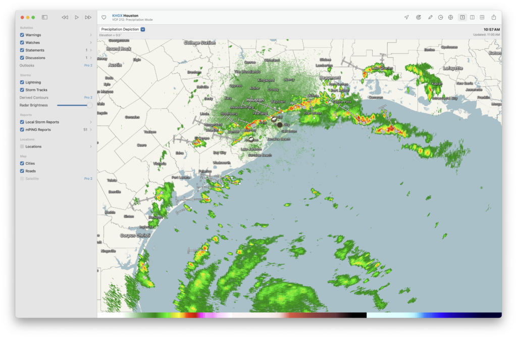
You can pick and choose specific radar stations, both in the United States and abroad, including 13 in Texas. It’s easier to use and navigate on a traditional PC, but still extremely useful on your phone. The help files in the desktop version are helpful, and there’s even a Facebook group you can join to learn from other users.
Windy
Windy is available as a website and an iOS/iPadOS and Android app. As the name implies, its initial focus is on wind conditions, but it’s really a full-featured weather app, with one very interesting features: You can track storms based on computer weather models. Choose the model you want, along with the date and time for a forecast, and it animates the storm on a beautifully rendered map.
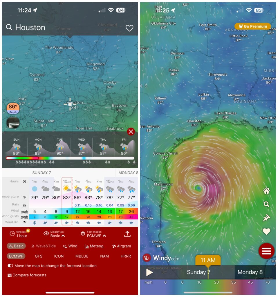
From the home screen, press and hold the Home icon. Tap the Basic label at the bottom to see the various forecasting models that are available. Choose one to see the storm at the current location, then scroll through the timeline to see where the storm is expected to be based on that model’s forecast.
While most of Windy’s features are available for free, some – like a 15-day forecast – require a subscription, starting at $2.99 a month up to $29.99 a year. But most folks can get along just fine with the free version.
There are many, many other weather apps and websites that can help you keep track of storm developments, and as I said at the outset this is not meant to be an exhaustive list of resources. (I didn’t even mention of my favorites, Merry Sky, which was developed for those who miss the look and feel of the old Dark Sky app. Oh, wait, I just did!) If there’s an app you like, feel free to let others know in the comments.
Tropical Storm Beryl Probabilistic Storm Surge Graphics
Beryl tracking toward Matagorda, center likely to pass near west side of Houston: Serious impacts expected
In brief: We are now less than 24 hours before Beryl will make landfall in Texas, likely near Matagorda, which is located about 90 miles south-southwest of Houston. Along this track the greater Houston area, particularly the western half of the metro area, will see significant effects in the form of strong, battering winds in addition to heavy rainfall. This post will assess all of these threats, and their timing.
Tropical Storm Beryl status
As of 7 am CT, Tropical Storm Beryl still has sustained winds of 60 mph. Its central pressure is largely unchanged overnight, dropping only slightly from 993 to 992 millibars. This indicates that Beryl has yet to begin the process of significantly intensifying. The storm is almost due south of Galveston Island, and is moving to the northwest at 12 mph.
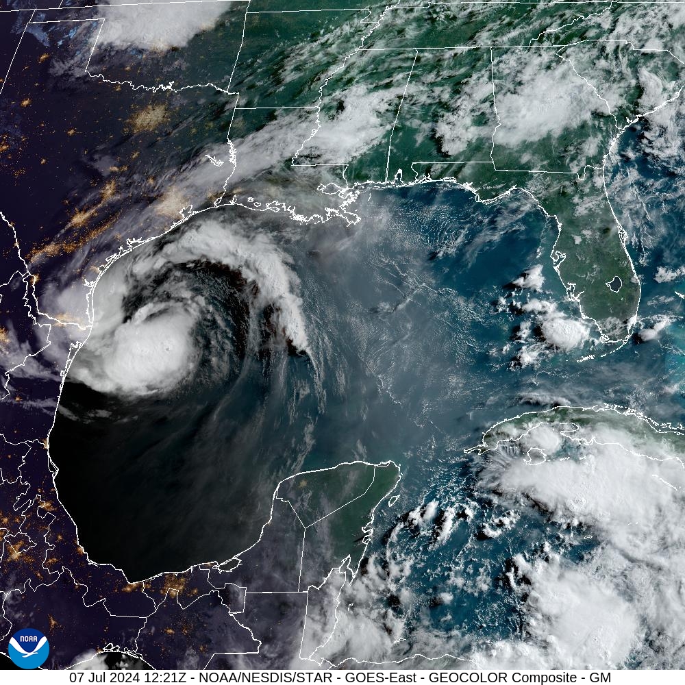
It is good that Beryl has not changed much overnight, but forecasters still expect the storm to find favorable conditions for intensification during the next 18 to 24 hours before it makes a final landfall along the Texas coast.
Track of Beryl and its intensity
The trends in the overnight model runs for Beryl have not been great for the Houston metro area. The most likely track remains a landfall near Matagorda, but this could still change today with a wobble in one direction or another as a better defined center of circulation forms. Along this track the Houston region will be subjected to some of the strongest winds and heaviest rains from Beryl.
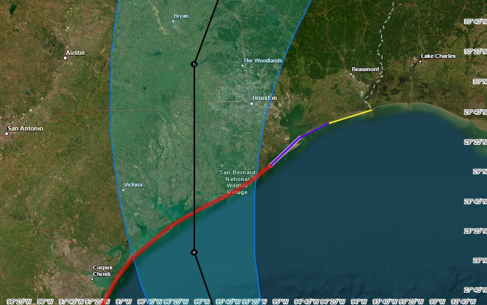
Forecasters still expect Beryl to intensify today, given the lowering wind shear levels and ample moisture in the atmosphere. The National Hurricane Center predicts the storm will be a Category 1 hurricane with 85 mph winds at landfall early on Monday morning. This could be an overestimate if Beryl continues to struggle with getting organized today. However, the most likely scenario is strengthening today, with the potential for rapid intensification tonight. Expect a Category 1 or Category 2 hurricane at landfall.
Conditions on Sunday prior to landfall
Beginning later this morning, Houston may see fairly widespread showers and thunderstorms as the outer rainbands of Beryl move inland. These storms may be briefly intense, but should be navigable for the most part. Winds will be increasing today and this evening from the southeast, but still within manageable levels, with gusts in the 20s. For coastal areas, conditions will start to deteriorate after sunset, with inland areas, including the city of Houston, seeing markedly stronger winds by late evening and after midnight.
Beryl’s winds
Beryl will produce strong winds near its center and to its right. Although there are still likely to be some subtle changes in the storm’s track and location of its is strongest winds, it is now clear that strong winds will cause significant impacts for the greater Houston area, including the potential for widespread power outages. The extent of these outages will depend on the strengthening of Beryl today and tonight as it nears the Texas coast. Other concerns include downed trees and damaged roofs. It is strongly advisable to secure loose objects today, prior to Beryl’s landfall.
The greatest impacts are likely to be in locations such as Sargent, Freeport, and Lake Jackson. However, tropical storm-force winds are also likely along Galveston Island and large parts of the Houston metro area, particularly to the south and west of the city.
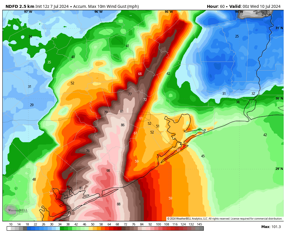
Matagorda, Wharton, Fort Bend, and Brazoria counties are likely to see the strongest winds, with sustained winds of 45 to 75 mph, and higher gusts. Most of the rest of the Houston metro area is at risk for winds of 35 to 55 mph, with higher gusts. If you’re wondering how these compare to Hurricane Ike, here is a map of sustained peak winds during that notable 2008 hurricane.
These winds will peak between late Sunday night and sunrise for coastal areas, and a little bit later for inland areas. Winds will be receding area-wide by Monday afternoon.
Beryl’s storm surge
Storm surge occurs when a hurricane’s winds align with the onshore flow, pushing large amounts of water onto land. Its most significant impacts occur over immediate coastal areas, and the storm surge level typically peaks along with high tide. In Beryl’s case, water levels are already higher than normal with the storm’s winds. Surge levels should peak between 6 am and 9 am CT on Monday before rapidly receding later in the day, likely reaching near-normal levels by Monday night.
Due to Beryl’s track, expected storm surge levels have ticked a little bit higher. Galveston Island and Galveston Bay should now see a surge 3 to 5 feet above normal levels.
Inland rainfall potential
Beryl’s track also places the core of its heavier rains over the Houston metro area. Coastal areas are likely at the highest risk for heavy rainfall, with 5 to 10 inches likely from Matagorda Bay to Galveston Island, and higher isolated totals. Further inland, much of the Houston area can probably expect 4 to 8 inches, with higher isolated totals. Since this rainfall will come down rapidly, we can expect streets to rapidly flood.
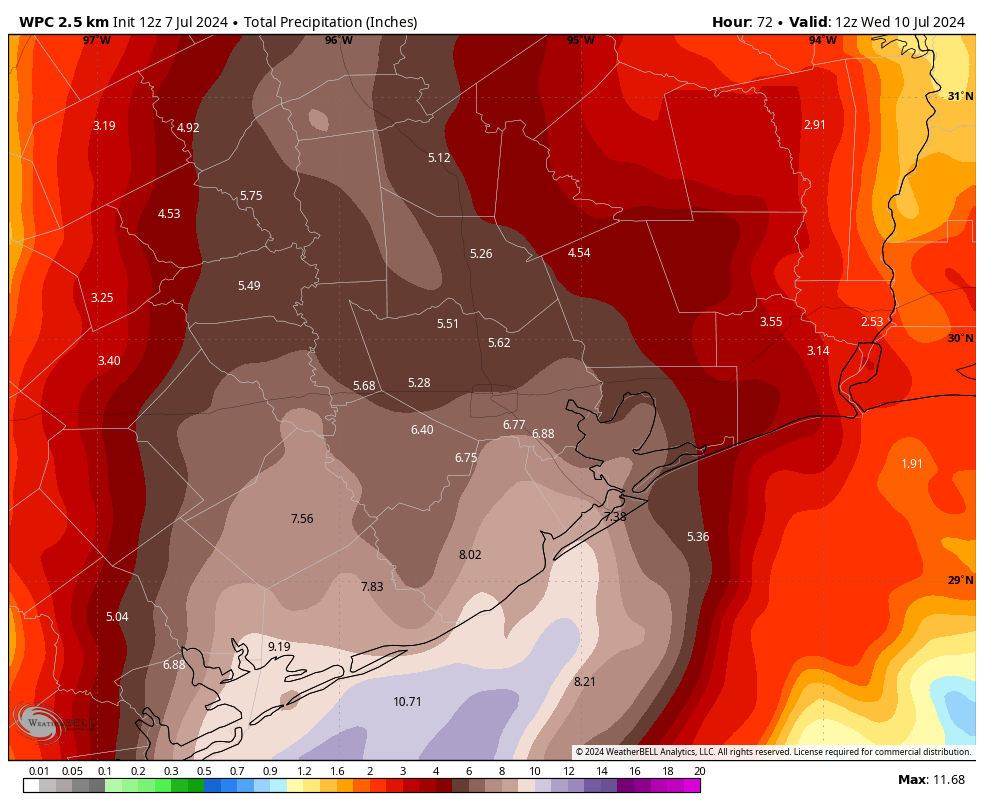
Although stronger thunderstorms will be possible this evening, the most intense rainfall should occur between midnight tonight and noon on Monday. After this time the storm will be pulling away to the north of the city. I cannot rule out an additional trailing band of rainfall later on Monday or Monday night. However, the fairly rapid northward movement of Beryl after landfall is our friend. We have issued a Stage 2 flood alert for the entire Houston metro area.
How should you be thinking about this
Beryl will be an impactful storm for the Houston region. This is far from a worst-case scenario hurricane for our area, but it will be significantly disruptive tonight and on Monday. Beginning this evening, you should shelter in your home. The worst of the winds and rains will come tonight and into Monday morning, with improving conditions thereafter. Due to the likelihood of street flooding on Monday morning, you should carefully consider any plans before noon.
The current track forecast indicates the possibility of widespread power outages, and the duration of these outages will depend on how many people lose power as it will mean more work for restoration crews.
In terms of programming, I will be conducting a video Q&A on our Facebook page at 1 pm CT today. You can submit questions in the comments below for that chat, if you like. Dwight will also have a post today about maximizing the potential of weather data on your phone to understand local conditions during the height of the storm. Our next major update on Beryl’s track and its implications for Houston will come around 4:30 pm CT today.
Comic for 2024.07.06 - Advice From Batman
Saturday Night Live: With your host, Beryl, and featured musical guest, Katrina and the Waves
In brief: Just a few thoughts to share on Tropical Storm Beryl tonight—basically some things I’ll be looking for on Sunday. If you’re looking for a nuts-and-bolts forecast of what impacts to expect in Houston on Monday, please see our post from earlier today, which holds up fine tonight. We’ll have a comprehensive update for you first thing in the morning.
When will Beryl start intensifying again?
As of late Saturday night, Beryl remains a high-end tropical storm with 60 mph winds. Its intensity has not changed much today, as expected, due to shear and entrainment of dry air. However, as we’ve been discussing, Beryl is moving into a more favorable environment tonight and on Sunday, and therefore it is virtually certain to re-strengthen.
One key question at this point is when Beryl starts to rev back up. This is because once Beryl starts to increase its winds, it likely won’t stop intensifying until it runs into Texas. So on Sunday I’ll be watching to see how soon Beryl’s winds start to increase, and how fast its central pressure (currently 993 mb) starts to fall.
The National Hurricane Center forecasts Beryl to come ashore as a Category 1 hurricane, with 85 mph winds. However, the forecasters there acknowledge that Beryl could rapidly intensify in the final hours before it comes ashore as the system reaches an environment with significantly lower wind shear. In addition, historically, we have seen hurricanes intensify as they near the Texas coast. The bottom line is that the later Beryl starts intensifying, the better, as it could easily become stronger than a Category 1 hurricane.
A silver lining: Beryl is moving at a good clip
One bit of good news is that the storm is moving a bit faster than expected, so it will have less time over water to get going. Some of our best models, including the European and GFS models, now bring the storm to the Texas coast around 2 to 4 am CT on Monday, several hours faster than previously thought. This will give Beryl less time to rapidly intensify.
The forward motion will also help with rainfall totals, both at landfall and after it moves onshore. Houstonians are justifiably jumpy when it comes to inland rainfall from hurricanes after Harvey, and this storm will make landfall only a little way up the coast from where Harvey did. But Beryl is no Harvey. In fact, the forecast for Beryl’s forward motion after landfall is also trending faster. So while I do expect to see some very intense rainfall in the Houston metro area on Monday, increasingly it looks as though the heavy rain will exit to our north by Monday night or early Tuesday.
We should have better clarity on Beryl’s impacts in Houston by tomorrow, as we’ll be less than a day before landfall. The bottom line is that everyone in the Houston area, but especially residents south and west of the city, should be prepared for heavy rainfall and higher winds on Monday. How much rain, and how strong the wind will be is something we’ll try to fully pin down in tomorrow’s forecast. This will, of course, depend to some extent on the rapid intensification (or not) of Beryl discussed above.
Have a good night, everyone.
Americans make odd choice to celebrate decision that led them to this point
“UNITED” STATES OF AMERICA – To the surprise of international observers, millions of Americans chose to celebrate the anniversary of their declaration of independence today, despite the fact that this decision has clearly not worked out. “It’s a bit sad really, seeing them run around with red, white and blue clothing while waving sparklers,” said […]
The post Americans make odd choice to celebrate decision that led them to this point appeared first on The Beaverton.
Brits replace their right wing party with centrist party for same reasons Canadians will soon replace our centrist party with right wing party
LONDON – In a clear message that voters want to see a progressive, compassionate centrist government, the UK has replaced the Tories with Labour. Just as soon, Canadians will replace the Liberals with the Conservatives in a clear message that voters want to see a traditional, conservative government. “Between the cost of living crisis, home […]
The post Brits replace their right wing party with centrist party for same reasons Canadians will soon replace our centrist party with right wing party appeared first on The Beaverton.
Little green mall wizard on a mission.

Little green mall wizard on a mission.
Pros And Cons Of Granting Trump Presidential Immunity

The Supreme Court recently made it more difficult to prosecute Donald Trump in his election interference case, ruling 6-3 along ideological lines to grant him partial immunity from criminal charges. The Onion explores the pros and cons of bolstering Trump’s presidential power by making any “core” constitutional act…
One Canadian's trash panda is another Canadian's treasure

Susan Boan of Regina has a lifelong passion for protecting and helping wild animals. She's carried this love for creatures and critters into her adulthood and spends her own time and money on taking in and rehabilitating injured or orphaned raccoons outside of her full-time job.
4th of July open thread
This post was written by Alison Green and published on Ask a Manager.
It’s a holiday!
This comment section is open for any discussion you’d like to have with other readers.
The game theory that led to nuclear standoffs

Last week, Vladimir Putin vowed to make new nuclear weapons and consider placing them close to NATO countries. Meanwhile, here in the US, the government boosted its nuclear weapon spending by 18% between 2022 and 2023.
The world is closer to nuclear war than it's been in at least forty years.
Today on the show: The game theory of nuclear war. When can mathematical models help us, and when can they lead us astray ... even to the brink of destruction?
Guest Kelly Clancy's book is Playing With Reality: How Games Have Shaped Our World.
Related Episodes:
How to get Russia to pay Ukraine
Congressional game theory
For sponsor-free episodes of The Indicator from Planet Money, subscribe to Planet Money+ via Apple Podcasts or at plus.npr.org.
Music by Drop Electric. Find us: TikTok, Instagram, Facebook, Newsletter.
The two companies driving the modern economy

At the core of most of the electronics we use today are some very tiny, very powerful chips. Semiconductor chips. And they are mighty: they help power our phones, laptops, and cars. They enable advances in healthcare, military systems, transportation, and clean energy. And they're also critical for artificial intelligence, providing the hardware needed to train complex machine learning.
On today's episode, we're bringing you two stories from our daily show The Indicator, diving into the two most important semiconductor chip companies, which have transformed the industry over the past 40 years.
First, we trace NVIDIA's journey from making niche graphics cards for gaming to making the most advanced chips in the world — and briefly becoming the world's biggest company. Next, we see how the Taiwan Semiconductor Manufacturing Company's decision to manufacture chips for its competition instead of itself flipped the entire industry on its head, and moved the vast majority of the world's advanced chip production to Taiwan.
Help support Planet Money and hear our bonus episode about NVIDIA by subscribing to Planet Money+ in Apple Podcasts or at plus.npr.org/planetmoney.
(Image credit: Annabelle Chih)
Coked-Up Nation Loves This Fucking Guy

LOS ANGELES—Emphasizing that he was exactly who you wanted in your corner when shit hit the fan, the coked-up nation announced Thursday that they love this fucking guy. “This guy? This guy right here? Quality fucking human being,” said 32-year-old Beverly Hills resident Greg Hanson, echoing the sentiment of 340…
A Day In The Life Of Steve Bannon In Federal Prison

On July 1, Steve Bannon reported to federal prison to serve a four-month sentence for acting in contempt of Congress. The Onion followed the former Trump advisor and far-right figurehead for 24 hours behind bars.
America Celebrates Fourth Of July

Citizens across America are having barbecues and setting off fireworks to celebrate the Fourth of July, the nation’s independence day. What are you doing to celebrate?
Forecast for Hurricane Beryl continues to trend south of Houston
In brief: The forecast for Hurricane Beryl and Houston remains more or less on track, which is to say the storm is still expected to go far enough south that it will not produce serious wind and surge impacts in Houston. We continue to watch the possibility of tropical rain next week.
Just a quick update on Wednesday afternoon to point out that our forecast from this morning on Hurricane Beryl, which currently as 140 mph sustained winds and is lashing Jamaica, is more or less on point. In fact, the data we’ve seen today from our most-trusted models continues to provide confidence in a track predicted by the National Hurricane Center. Their outlook brings a strong tropical storm or Category 1 hurricane to the northern Mexico coast, 50 to 100 miles south of Texas, on Sunday evening or Monday morning.
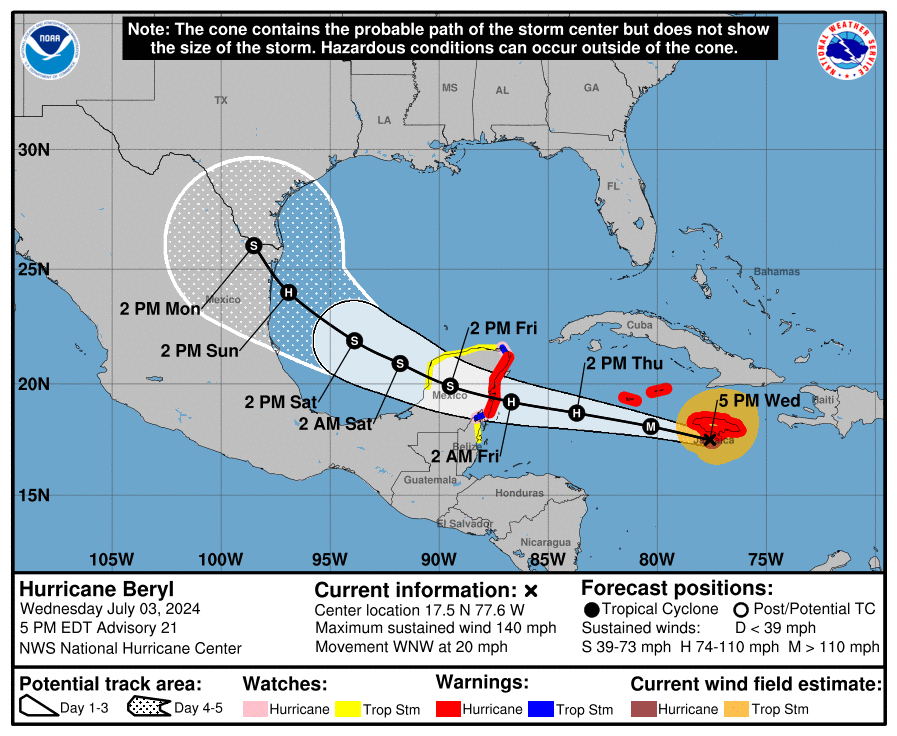
We are still four to five days out in terms of a track forecast, so there are no absolutes here. But the fact that we’ve seen a convergence in modeling today, particularly in a track forecast from both the European and GFS models, gives me further confidence that Beryl, with its winds and seas, will likely not be much of a factor in Houston’s weather next week.
There is still the potential for heavy rainfall, particularly during the Monday through Wednesday timeframe. My sense is that the most likely scenario is that much of our region will pick up 2 to 4 inches of rainfall, with higher bullseyes. But I do not have as much confidence in the precipitation forecast, and certainly we cannot preclude the possibility of intense tropical rainfall and flooding in the Houston metro area. For now, however, we have no plans of issuing an alert on our flood scale. We’ll continue to monitor things, of course.
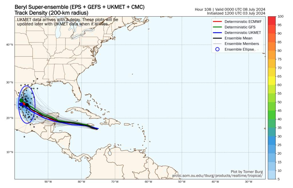
The bottom line is that Beryl is probably going south, and making a final landfall in northern Mexico. There will be some impacts for South Texas, including the possibility of inland flooding. As ever with tropical weather, forecasts can change. We’re just getting closer to the point where we can definitely say they won’t in regard to Beryl and Houston.
I’ll have a full update on Houston’s weather for you tomorrow morning, on the Fourth of July.
Man angry about 15-minute cities wouldn’t last a day in Europe’s 15-minute countries
MARTENSVILLE, SK ― Sources close to Terrence Graves, a local mechanic, report that the 54-year-old who has been grousing for months about the entirely unrealistic dream of making North America the slightest bit walkable, has yet to hear of San Marino. They further note that everyone around him fervently hopes it stays that way. Graves, […]
The post Man angry about 15-minute cities wouldn’t last a day in Europe’s 15-minute countries appeared first on The Beaverton.
A new way to prevent HIV delivers dramatic results in trial

The testing of lenacapavir was halted because results were so impressive — 100% effectiveness. The decision was made to give all participants the injection rather than the alternative daily pill.
(Image credit: Barbara Debout)
Nearly Half Of All Borrowers Have Not Restarted Student Loan Payments

After the three-year pause on student loan repayment programs during the pandemic ended, 19 million borrowers either let their accounts become delinquent or extended their payment pause, leaving $1.6 trillion in debt being uncollected. What do you think?
