KWBaker
Shared posts
Starlink Hits 250,000 Customers, Elon Musk Hints: SpaceX Booking Over $300 Million/Year

Cassina’s New Collection Celebrates a 1950s Architect Whose Furniture Designs Are Coveted Again

The Shopping Centers Of Tomorrow Are Here Today In Las Vegas

Where We Got Doritos
1955 Disneyland Casa de Fritos Matchbook https://t.co/qfLqdDgDkLpic.twitter.com/AkwhcbABs9
— Cory Doctorow RIGHT-CLICKING WORDCEL MENTALITY (@doctorow) November 12, 2018
Does anyone remember the restaurant Casa de Fritos at Disneyland? It was sponsored by Fritos (later Frito-Lay) and served Mexican food at the park -dishes heavily dependent on Fritos- from shortly after the park opened until the name was changed in 1982. You could get a full combination plate there for a dollar, and then purchase a small bag of Fritos from an elaborate vending device featuring a statue of the Frito Kid. Casa de Fritos got their tortillas delivered from a manufacturer called Alex Foods.
“One day, a salesman from Alex Foods noticed that Casa de Fritos was dumping stale tortillas in the trash,” Bob Sorokanich wrote for Gizmodo. “He gave the kitchen a tip: instead of trashing the stale tortillas, cut them up and fry them.”
Now, mind you, this wasn't an original idea from the tortilla salesman. He was passing along a trick that came from tortilla manufacturer Rebecca Webb Carranza that had been in use since the 1940s to produce tortilla chips. But the resulting chips became very popular at Casa de Fritos, and Fritos partnered with Alex Foods to market them nationally in 1966. Read the story of how Doritos came about and took the country by storm at SFGate. -via Digg
Toyota files patent applications for manual transmissions for EVs - Roadshow

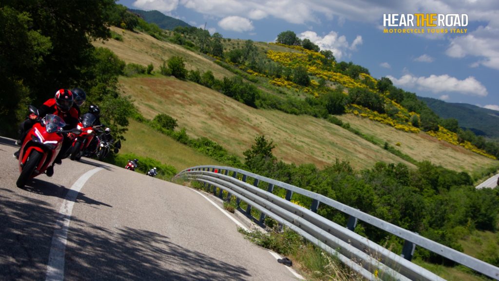
Hear the Road Motorcycle Tours Italy Announces 2022 Calendar
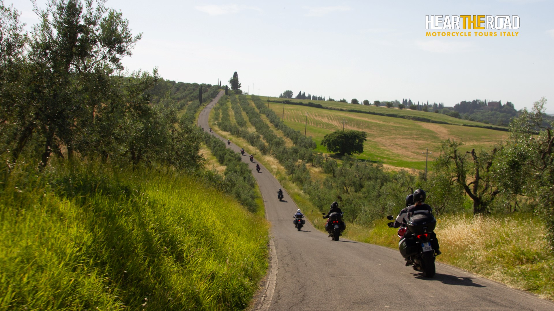
Ready to ride a motorcycle in Italy? Hear the Road Motorcycle Tours Italy has announced its 2022 Italian motorcycle tour calendar.
Tours for 2022 have a range from 8-12 riding days in an effort to suit everyone’s wish to ride the best scenic Italian roads, visiting destinations like the Amalfi Coast, the Alps, the Dolomites, Tuscany, Chianti, Sardinia, and Corsica, as well as riding a Ducati Panigale on a MotoGP circuit or watching the MotoGP race at Mugello and Misano.

So, whether you crave twisting country roads, historical destinations, spectacular views of the mountains and the Mediterranean, or 4-star hospitality, there is a tour for you!
Tours are led by Enrico Grassi, the owner and founder of the company, a life-long Italian motorcyclist who is excited to share his passion and knowledge of the country he loves and knows so well.
All Hear The Road motorcycle tours have been planned by Enrico in every detail. He spends the winter months in his studio, road maps spread over the desk, exploring new routes to travel down, finding out about local events, country festivals, interesting exhibitions, tasty eateries – any kind of experience that can make HTR tours more interesting and exciting.
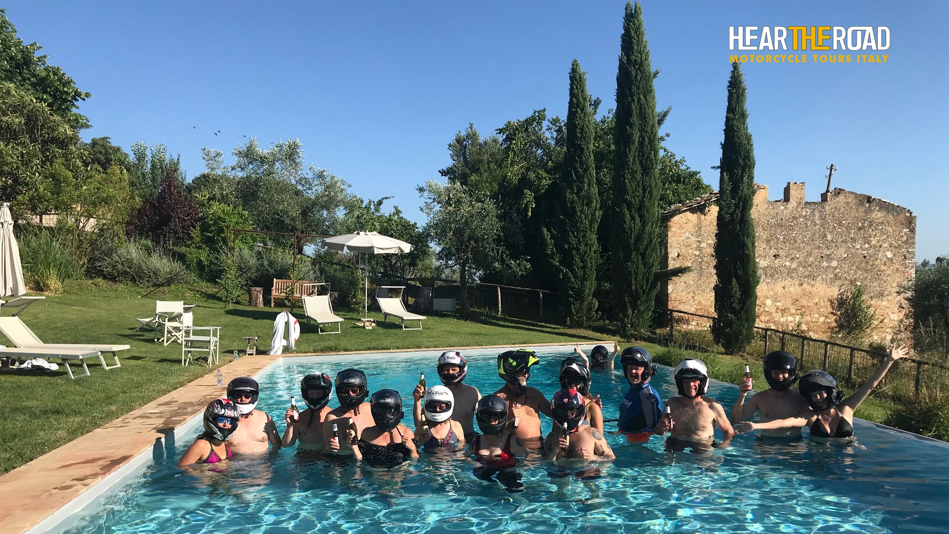
Hear The Road Motorcycle Tours Italy provides motorcycle rental, accommodations in 3- or 4-star hotel with local flavor, luggage transportation, and transfer from and to the airport.
Tours are on BMW, Ducati, Moto Guzzi, and Harley-Davidson motorcycles.
Tours run from April to October, so book soon if you plan on making this riding season the most memorable yet.
Hear the Road Motorcycle Tours Italy also caters to those riding enthusiasts that long for a riding tour in Italy but can’t meet the calendared tour dates. Self-guided, customized and/or private tours are a popular option for individuals or groups of any size.
For more information, visit motorcycletoursitaly.com.


Champagne House That Saved A Town During WWI Is Now Saving Environment

Why Championship Chess Sets Are So Expensive

We can easily purchase a chess set for around $20 or less. However, did you know that a handcrafted wooden chess set that is certified for the World Chess Championship can cost you as much as $500? All certified chess sets need to have knights that look the same, and there are only ten people or fewer that are trained to carve knights for these special sets. Business Insider visits a factory in Omrisar, India, to learn about the process of making these chess sets to provide a context as to why they’re so expensive.
Best Car Buffer for 2022 - CNET

New Hampshire Is the Freest State in America. Here's Why
Move over, Florida.
Artisans de Geneve Grand Bleu Rolex Deepsea Watch

Visit Uncrate for the full post.
The Best Chef’s Knife

A great chef’s knife can revolutionize your daily meal prep. If your knife is comfortable to grip and razor-sharp, you can chop ingredients faster and with more control (and therefore more safely).
After putting in over 150 hours of research — and chopping more than 70 pounds of produce with 23 knives — we recommend the Mac MTH-80. It’s been our pick since 2013, over the years appealing to a wide range of testers for its comfortable handle and sharp, agile blade.
This Luxury Train Now Offers a Stunning Scenic Journey Through the American Southwest

Singer Porsche 911 Turbo Study

Visit Uncrate for the full post.
The Future Of Drone Technology Is This Robotic Crow

Concept designer Amin Akhsi created the Hooded Crow, a conceptual flying machine that could help with reconnaissance and rescue missions. The robotic bird is part of the artist’s series of bionic birds. The crow is designed to be sleek and friendly, with the colors of black and light gray adorning the robot.
This design for a more advanced drone adds flexibility in neck movement through fabric materials on its neck. In addition, Akhsi attached fabric inserts with soft cushioning in the bird’s wings to help maintain its aerodynamic stability. Read more about the concept here.
Image credit: Bionic Birds via Yanko Design
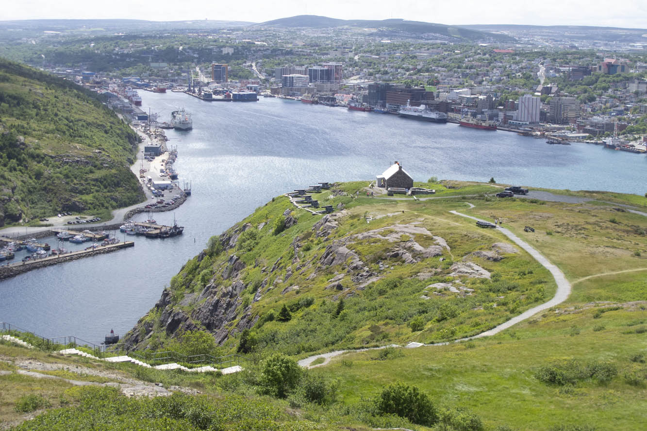
On the Road: Newfoundland

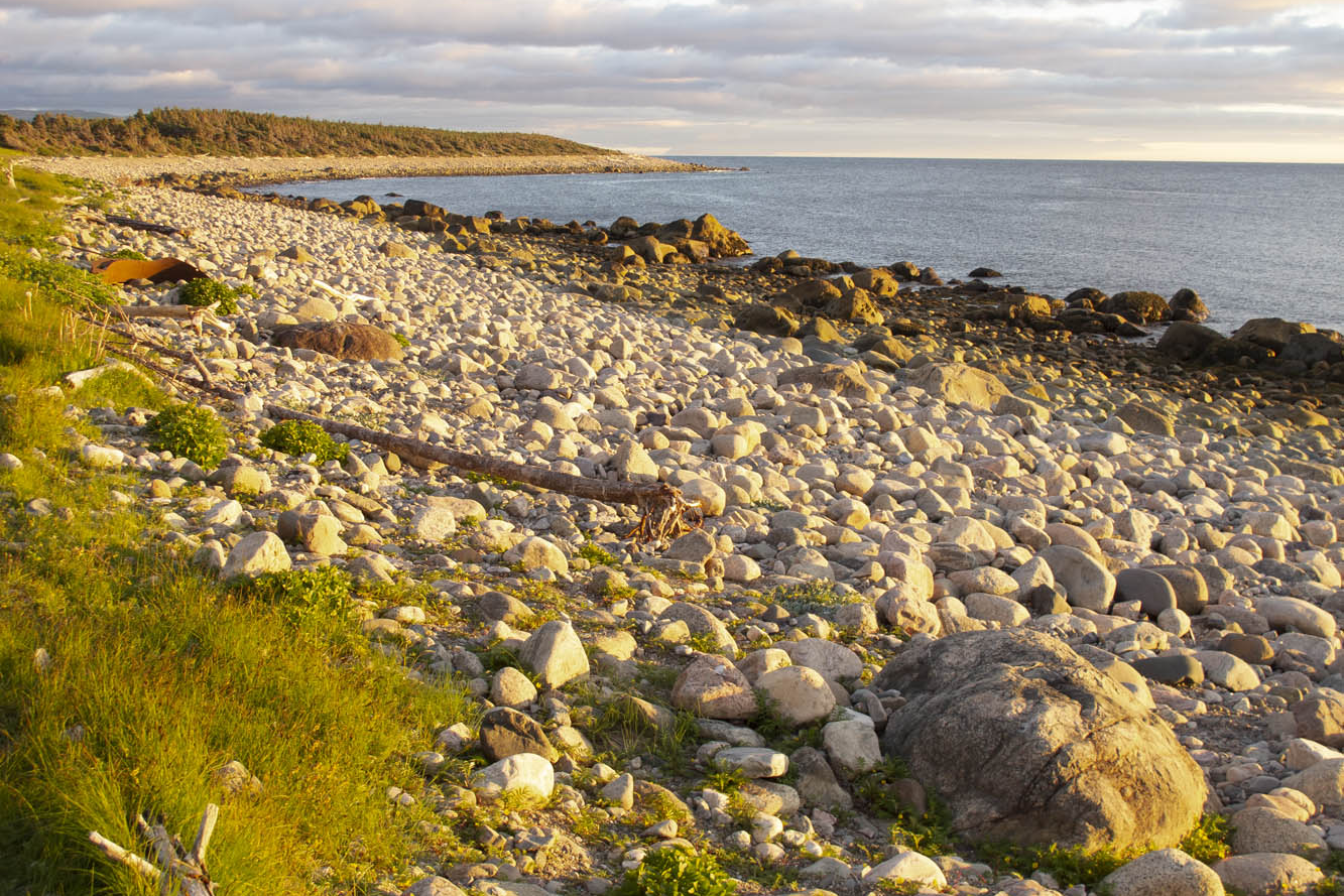
Newfoundland and Labrador, the easternmost province in Canada, fights a losing battle patching its roadways. Realizing it’s a lost cause, the province simply erects signs along the way warning “Potholes Ahead.” It’s a challenging slalom on a motorcycle, let alone in a car. I watch the suspension jolt on the van ahead carrying my wife and two teenage sons. New struts and an alignment are in order upon our return.
This is a cautionary tale about undertaking a “family vacation” when your family is in a van while you expect to experience the freedom of tagging along on your motorcycle. My wife, Nancy, has the notion of taking a ferry across the strait to coastal Labrador on the mainland to drive the mainly gravel Trans-Labrador Highway after we’ve finished our tour of Newfoundland. I, on the other hand, have serious reservations about adventure biking on my 850-pound beast of a BMW K1200LT, now with more than 200,000 miles on it. So, we will part ways after the ferry crossing to Labrador. And soon thereafter I would learn a bit of humility from some Canadian riders.
Meanwhile, we have arrived on Newfoundland’s Avalon Peninsula after a 16-hour ocean crossing from North Sydney, Nova Scotia. We enter fog and wind on our southern loop around the peninsula by way of Trepassey Bay, common weather features in this part of the country. But conditions improve at Lord Baltimore’s Colony of Avalon, the best preserved early English colonial site in North America. Archaeologists continue to dig as we tour the area. At the nearby Tetley Tea Room by the Sea, we sample our first Newfoundland cod and wild berry treats.
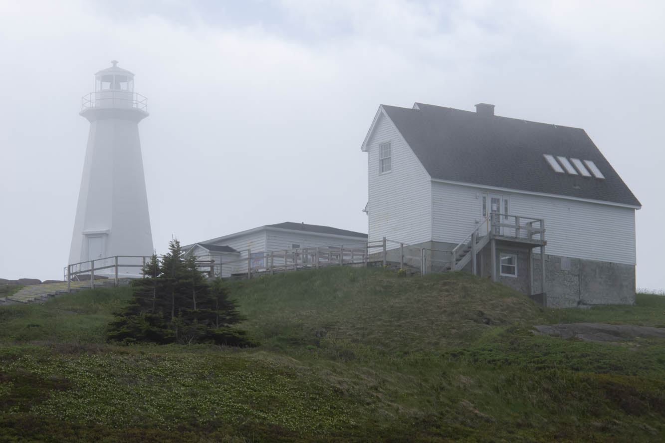
Nearly 100 lighthouses once peppered the shorelines of Newfoundland and coastal Labrador, and we encounter our first ones at Cape Spear, the easternmost point in North America. One, dating back to 1836, is the oldest surviving lighthouse in the province. The more modern one, erected in 1955, houses an adjacent museum. Here we learn there are 23 staffed lighthouses remaining in the area. In the distance we saw Signal Hill, our next destination.
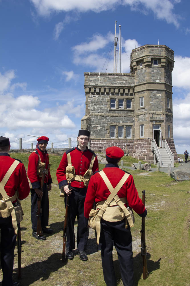
We negotiated the downtown minefield of St. John’s to reach a better perspective of the city from Signal Hill National Historic Site. The narrow harbor entrance drove many a sailing ship to peril. A colorful regiment of signal corps were practicing for their daily tattoo in front of Cabot Tower, a sandstone Gothic Revival structure begun in 1898 to commemorate the 400th anniversary of Italian John Cabot’s discovery of Newfoundland and the 60th anniversary of Queen Victoria’s reign. Marconi received the first wireless transatlantic transmission here in 1901.
Nancy wanted to explore downtown St. John’s, while I desired to escape Newfoundland’s capital and largest city. Changed my mind at lunch in a rathskeller dive where we were served outstanding cod burgers and I discovered Iceberg Beer. St. John’s Quidi Vidi Brewery claims it is enhanced by pure 20,000-year-old iceberg water. I detect crispness in this pale lager that similar brews lack. Our two boys, both crew rowers, were excited to find out from our friendly waitress that the Royal St. John’s Regatta is North America’s oldest continuing sporting event. That’s appropriate, since St. John’s is the oldest English-founded city on the continent.

The Trans-Canada Highway leads us inland through the Eastern Region. Insidious longitudinal potholes jar the unwary. Canadians whoosh by, heedless of the hazard. My shocks are taking a beating, and they were leaking even before this trip. We set up camp at Notre Dame Provincial Park in the Central Region, and I take to the van for exploration around Twillingate. At Boyd’s Cove, we visit the Beothuk Interpretation Centre to learn about the extinct native inhabitants of Newfoundland.
In a tiny outpost called Clarke’s Head, I backed the van into a local’s vehicle at a gas station. “See what trouble I get into when I’m off the bike?” I say to my wife. The Newfoundlander was almost apologetic for being in my way, and we parted in friendly fashion. I can’t imagine that happening back in New York.
I mounted the bike for our next excursion up the Baie Verte Peninsula. The 50-foot skeleton of a humpback whale was worth scrutinizing at King’s Point. On the way to the tip of the peninsula at Fleur de Lys, we diverted to Smith’s Harbour, having learned that a huge iceberg had settled there. Indeed it had, and a picture perfect little place it was. These bergs drift off from the Labrador Current into nearby harbors, bays, and coves brought here by the wind and tide.
Back in the town of Baie Verte we learned about the peninsula’s rich mining history. Indeed, we passed a huge abandoned asbestos mine on the way to Fleur de Lys, where soapstone was quarried by the Dorset Paleo-Eskimo some 1,600 years ago. After reaching the end of the road, we were about to turn around when a pickup raced up and blocked our way.
The driver turned out to be a friendly local resident who noticed our New York license plates and wanted to chat. Encounters like this were common for us throughout Newfoundland.
So far, our progress was slow. Stopping frequently and visiting the numerous outport villages didn’t accumulate the mileage. Many were the dead-end roads we explored. I reviewed my mileage log once we were in the Western Region: 70 miles one day, 105 miles the next, followed by 90 miles, 62 miles, then zero, zero. Aaaughh!
I finally rode a 200-mile day from Baie Verte to Trout River campground in Gros Morne National Park. This area is a UNESCO World Heritage Site defined by ancient up-thrust landscape forming the tip of the Appalachian Mountains. The Tablelands region exposes examples of the earth’s mantle. Glaciers carved out a fjord at Western Brook Pond, where we took a boat ride beneath 2,000-foot cliffs. Ice fields cling to crags, offering summer habitat to the caribou and puffins.
If there was a central point to this wilderness, it would be picturesque Rocky Harbour, sheltered by a lighthouse promontory and twin Appalachian ridges dipping into the Gulf of St. Lawrence. The Gros Morne Wildlife Museum in town is worth a look. The Ocean View Hotel displays unique local artwork and hosts the Anchor Pub, where one can be “screeched in” as an official Newfoundlander. The boys were greatly disappointed they weren’t allowed to drink the rum and kiss a codfish. Earl’s restaurant offered moose burgers, moose soup, moose pizza, and any other variety you’d like. We left sated.
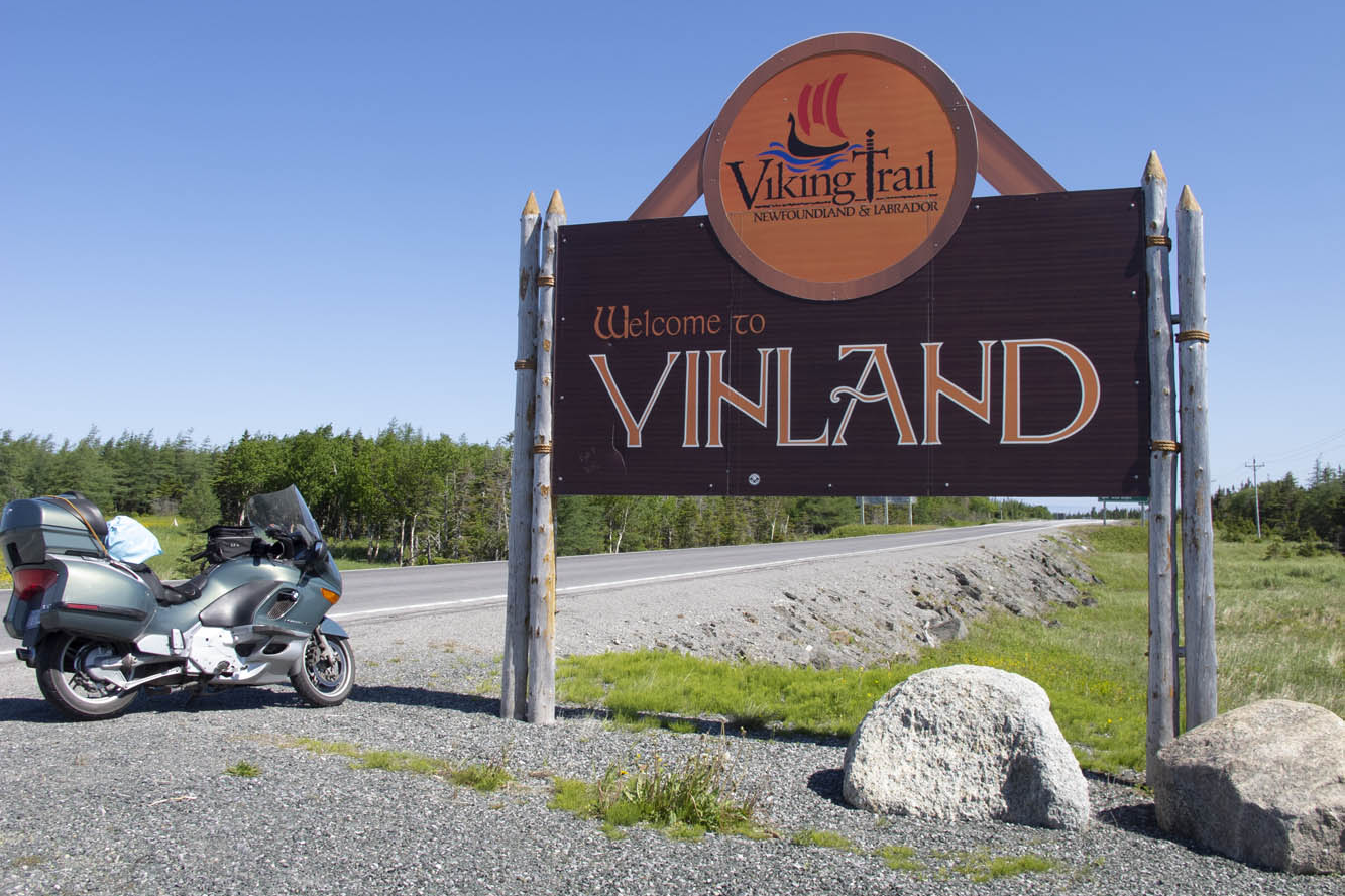
I gave the BMW free reign on Route 430 up the western coast of the Northern Peninsula, a smooth-surfaced road flowing alongside the Gulf of St. Lawrence, with the Long Range Mountains framing the eastern horizon. Felt like being back on Highway 1 in California. This is the Viking Route that would lead us to the first established European settlement in North America at the very tip of the Northern Peninsula. It also has the largest density of moose on the continent, and we had already seen several.
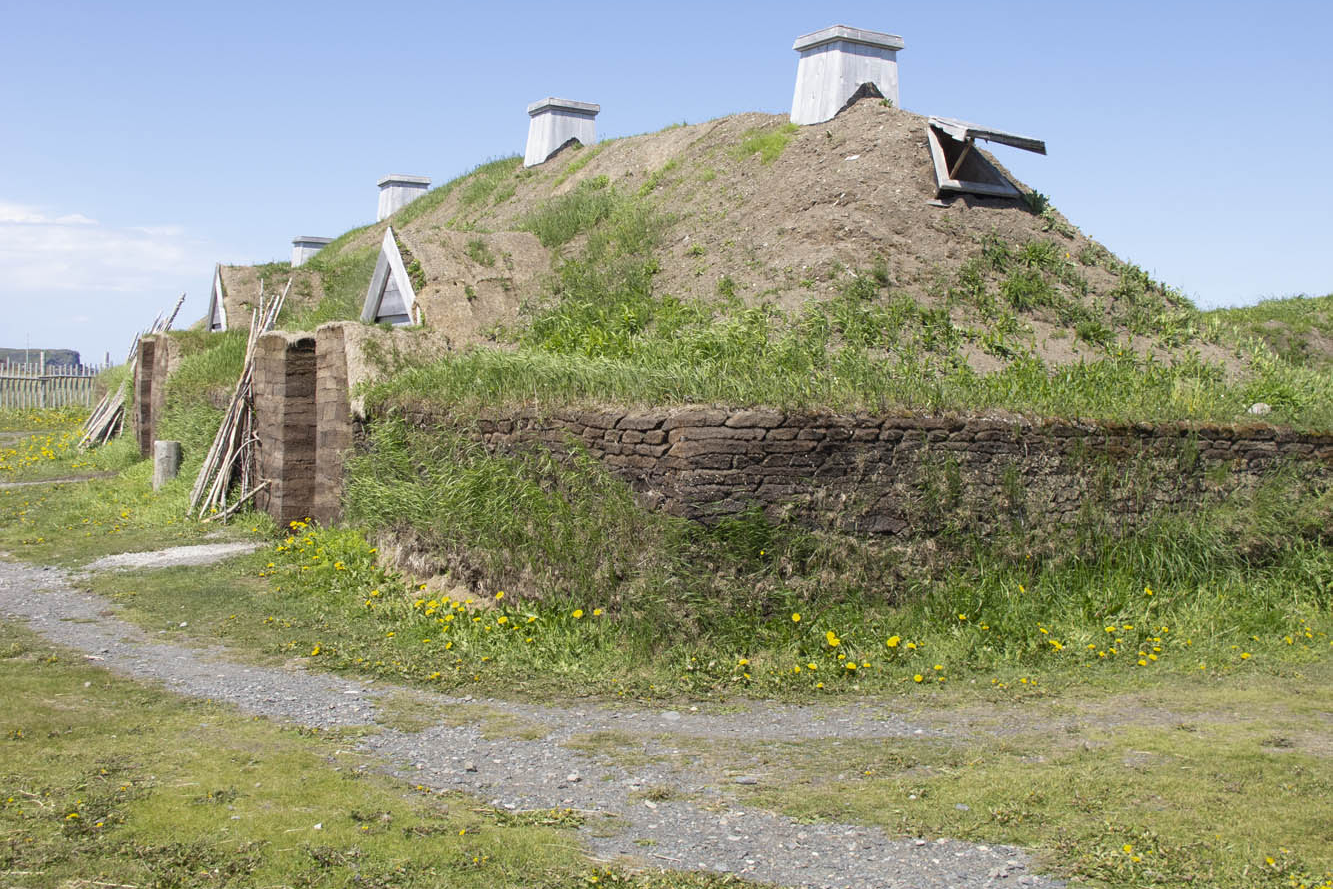
We had fun interacting with interpreters at L’Anse aux Meadows National Historic Site, location of the Viking presence here in 1,000 A.D. We walked through a reconstructed encampment of turf-walled longhouses while re-enactors stayed in character demonstrating the daily life of the Norsemen. Our tour continued at nearby Norstead, a living history site of additional costumed interpreters and a fully replicated Viking ship.
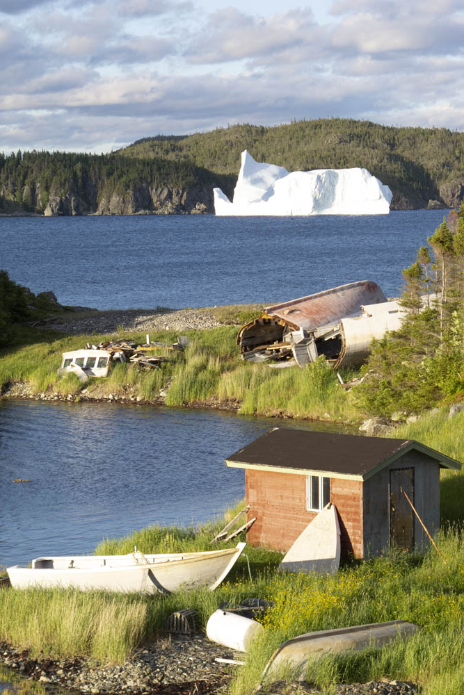
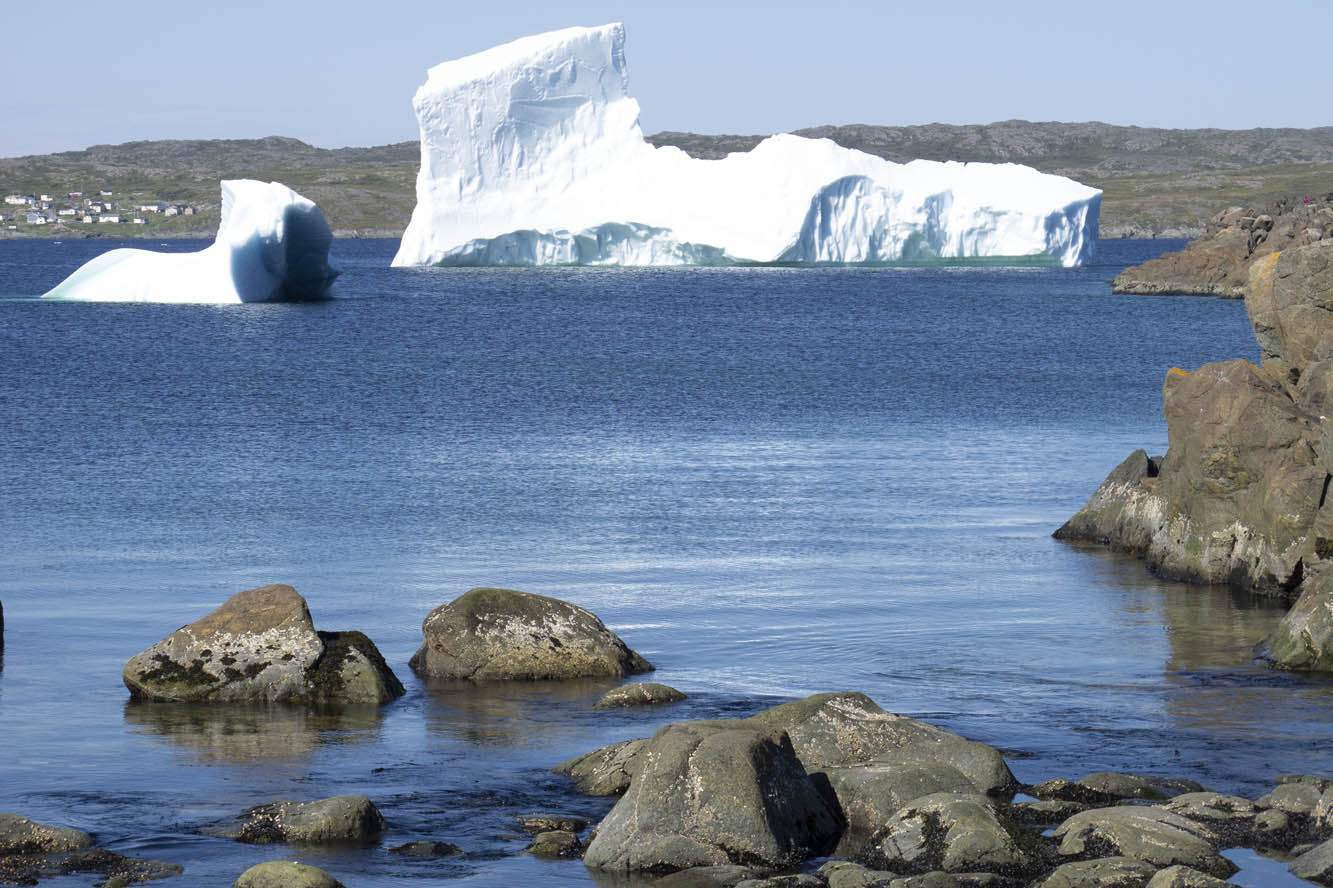
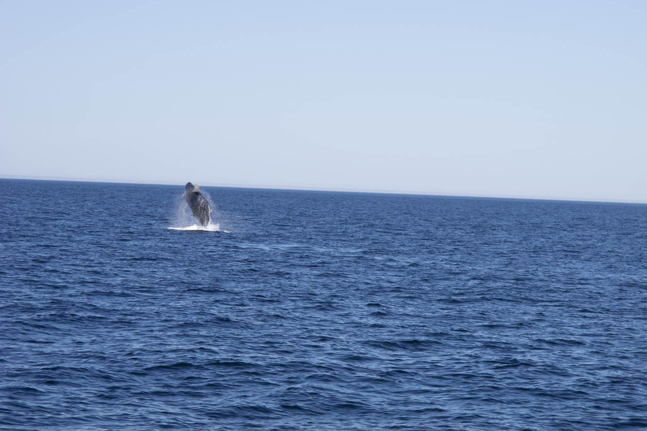
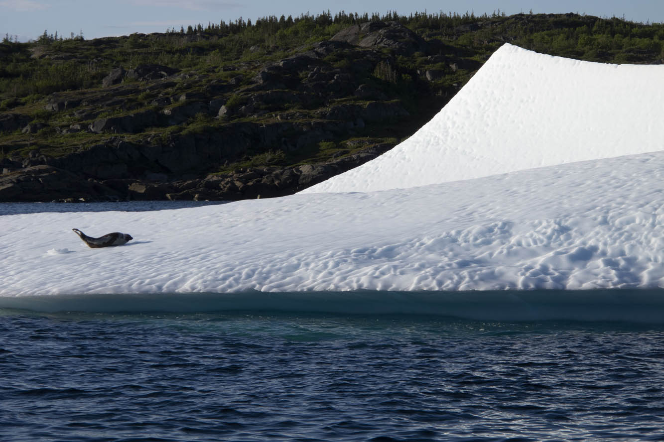
We hit paydirt in St. Anthony, viewing a harbor filled with icebergs. A boat tour brought us up close to these ice cathedrals. A humpback whale breached for us several times. A pod of minkes came alongside the boat. A seal reclined upon his private ice floe. We absorbed the opportunity, because two days later the icebergs had broken up, which can happen quickly we were told. By mid-July any icebergs become a rare sight.
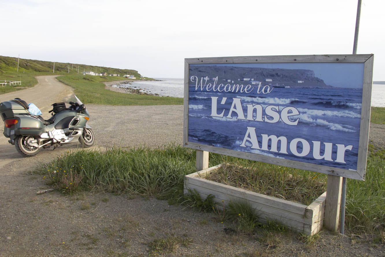
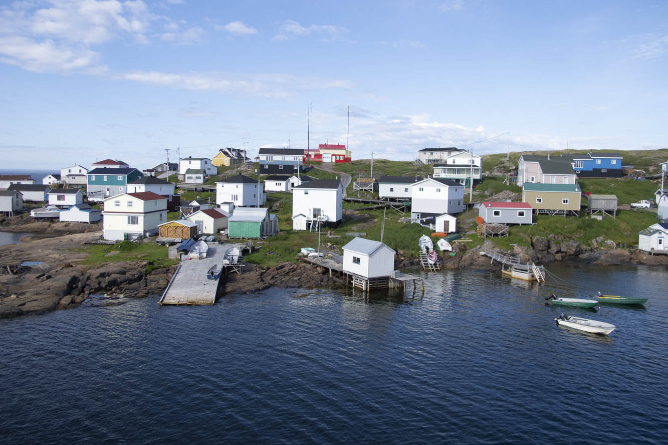
A ferry took us across the Strait of Belle Isle to coastal Labrador. A 50-mile ride brought me along the strait and over the mountains to Red Bay, a 16th-century Basque whaling port. Red Bay also offers access to the Trans-Labrador Highway, and this is where my family and I parted company. I had reservations aboard a supply ship that routinely sails upstream to replenish harbor towns with no connecting roads along the Quebec coast.
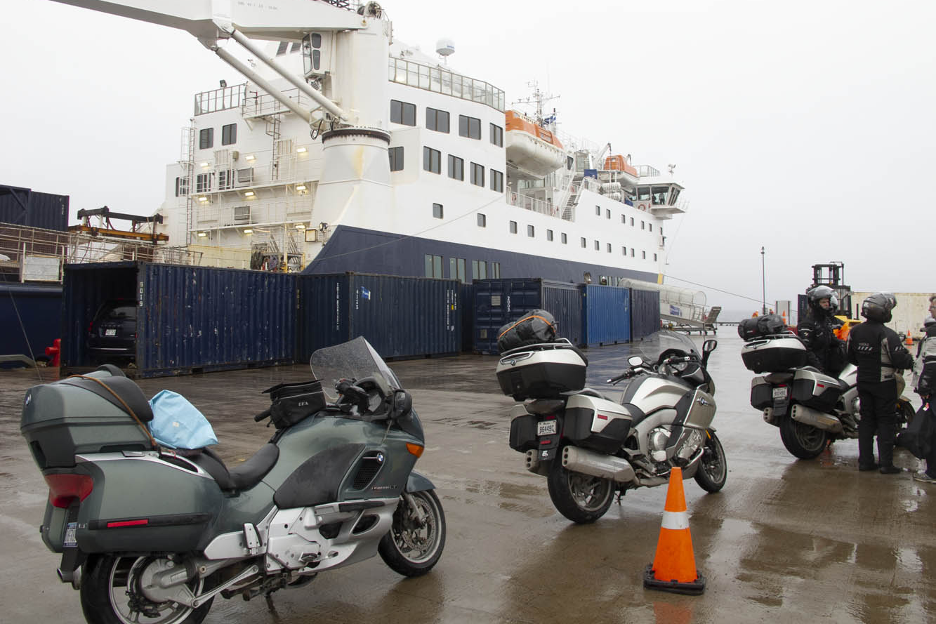
I returned to the ferry landing at Blanc-Sablon, Quebec, and lined up with other motorcyclists early on a rainy morning. The bikes were loaded two to a container, tied down, and hoisted by a mammoth boom crane into the vessel. Two Honda ST1300 riders humbled me because they had just completed the Trans-Labrador trek. We would disembark where the road begins anew in Natashquan. Or so we thought.
Circumstances changed upon reaching the village prior to Natashquan hours behind schedule. We all had reserved respective B&B inns in Natashquan, where we wouldn’t arrive now until the wee hours of the morning. We learned there was indeed a 20-mile road from the village to Natashquan, but it was all gravel. Nonetheless, all riders, except me, decided they would disembark here and risk the unfamiliar road in the midnight blackness.
Now, I’ve ridden my share of gravel roads, I told them. Even did the 1,200 miles of Alaska Highway when it was unpaved. But I was much younger and more fearless. My concern today was dropping my precious K1200LT, resulting in thousands of dollars in cosmetic damage. But my bike shared a container with one of theirs, and all looked askance at my weak rationalization. To regain self-respect, I agreed to accompany them.
It turned out to be the most anxiety-inducing 20-mile ride of my life. Inky blackness and bunched gravel had me plowing from one side of the road to the other, trying to find a tractable groove. It didn’t help that I was reluctant to get the speed up. One of the Canadians on his Kawasaki Tengai remained behind me for assurance, urging me to stand on the pegs and go faster, while the rest shot ahead. Such humiliation, I thought. When we finally caught up, the group was parked at a pullout on the outskirts of town.
“How’d he do?” asked one of his Canadian co-riders.
After a slight pause and a sly smile directed at me, he replied, “Slow, but steady.”
And with that turn of phrase, my newfound Canadian friend preserved my dignity, eliciting congratulatory backslapping and an acknowledgment of a successful ride all-around by the French-Canadians in a language universally understood.
The next day, while imagining my wife and boys bouncing along the rutted Trans-Labrador – views blocked by boreal forest and swatting at clouds of black flies – I rode 390 blissful miles of coastal Quebec. Open-road freedom never felt so good.
The post On the Road: Newfoundland first appeared on Rider Magazine.America First Trade Policies Harming U.S. Companies In China

How to Actually Listen to Apple Music's Lossless Tracks on Your iPhone
You need a portable DAC (and a good pair of wired headphones). These are the best ones to amp up your Apple Music experience.

Best Air Compressors for 2022 - CNET

Ford Unveils a New GT Heritage Edition to Honor Its 1966 Le Mans Win

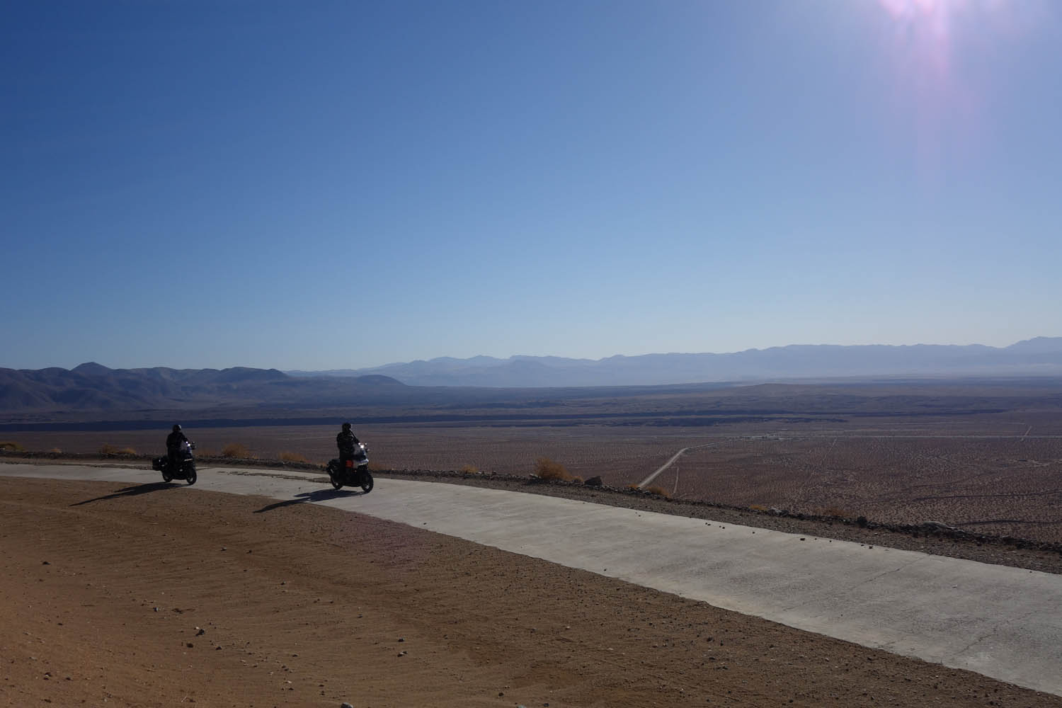
Favorite Ride: Los Angeles Aqueduct
The Los Angeles Aqueduct is an engineering marvel, a 233-mile channel that carries Sierra snow melt from California’s Owens Valley into the San Fernando Valley. Its five-year construction, completed in 1913, changed the face of Southern California. Without it, there would be no Los Angeles.
But because of it, there was tragedy. Draining the Owens Valley destroyed an entire farming region and turned to dust a lake once grand enough that steamboats crossed it. Building a dam to hold the stolen waters resulted in the second deadliest disaster ever to strike California when the dam collapsed.
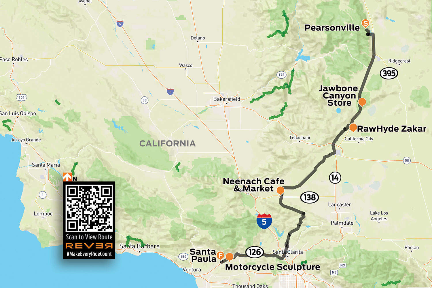
Click here to view the route above on the REVER app/website
Much of the aqueduct is open waterway, but the rest is a covered concrete channel. And most of that channel functions as a public road. We took a trio of Harley-Davidson Pan Americas and tried to see how much of it we could ride.
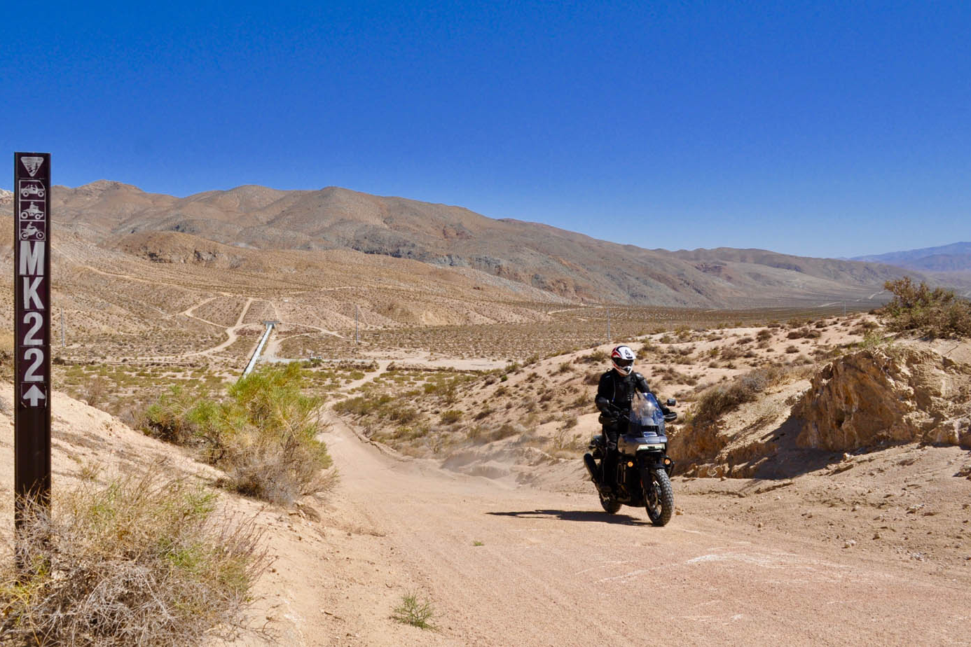
It was a hot May morning when we set out from Zakar, a compound that serves as base camp for RawHyde’s adventure motorcycle training school in the Mojave Desert. We wanted to beat the worst of the heat, so shortly after dawn we dashed up State Route 14 to U.S. Route 395 and exited at 9 Mile Canyon Road to catch our first leg of the aqueduct.
On maps, it’s called “Los Angeles Aqueduct.” Under our tires, it was a crunchy, crusty roadway, often covered entirely in sand and gravel, that followed the contours of the lowest reaches of the Sierra Nevada mountain range. We had to leave the hills after a few miles as the aqueduct went underground, running in tunnels through the foothills. (The aqueduct includes 142 such tunnels, comprising 52 miles of its total length.)
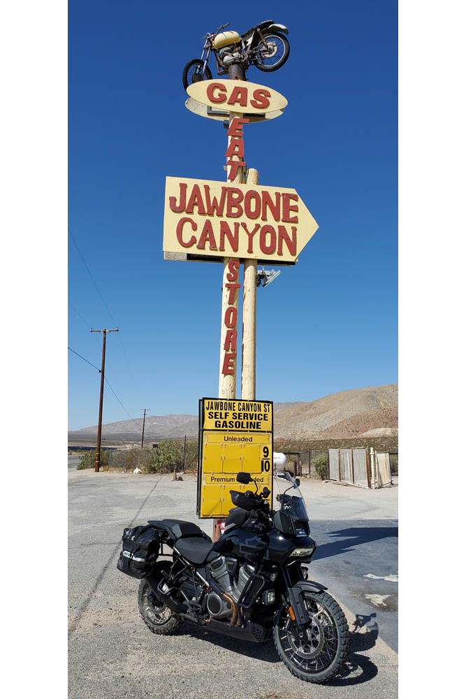
Back on the slab, we stopped for cold drinks at Robber’s Roost Ranch, and again at Jawbone Canyon Store, the “Mad Max” meets “Motocross Zombies from Hell” waystation popular with the off-road bike and buggy crowd. Further south, we were able to pick up the aqueduct again from Pine Tree Canyon Road. From there, we had a spirited 13-mile run of sand and concrete climbing high above the flat desert floor before dropping us down into the town of Mojave.
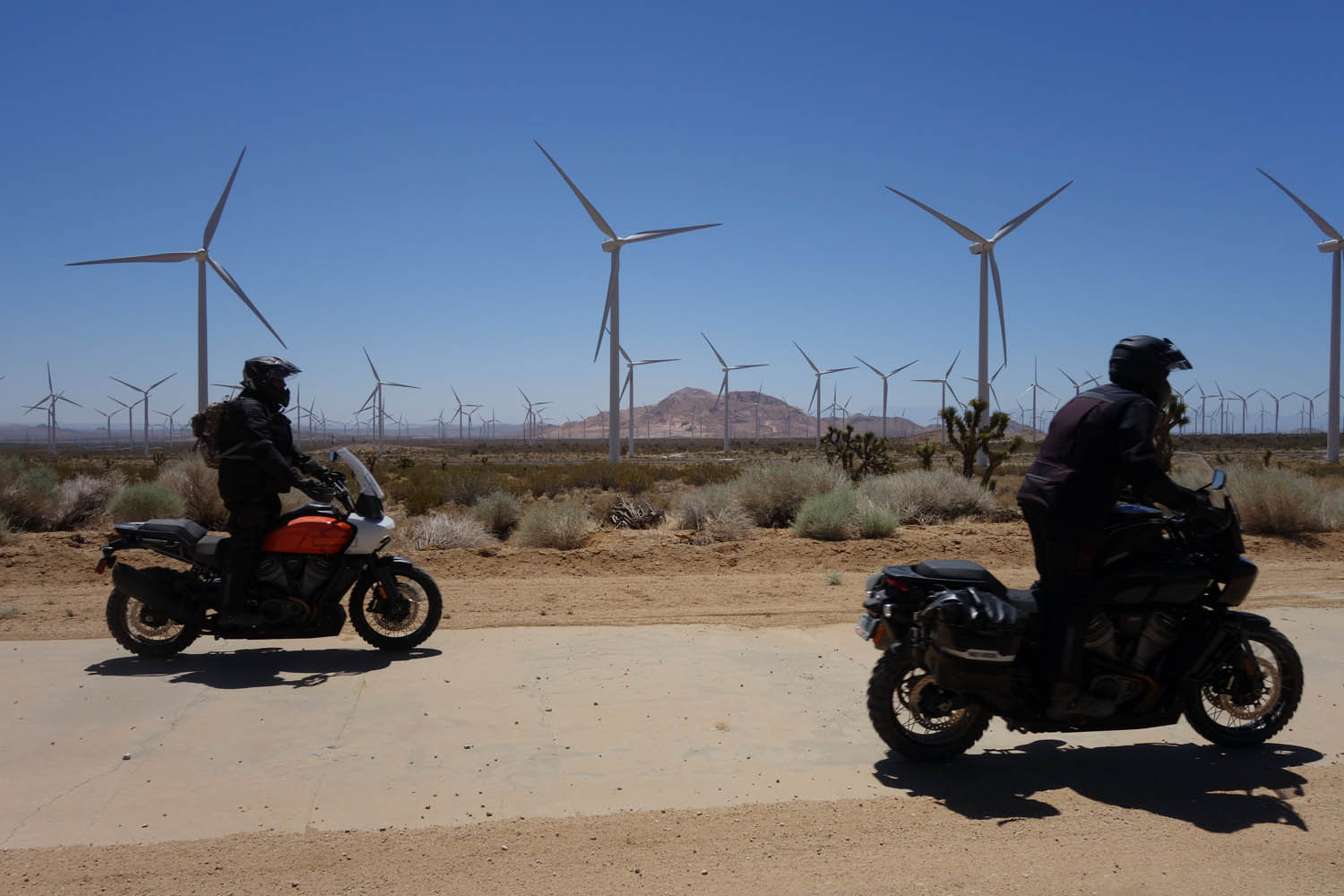
The aqueduct left the mountains, taking us with it for a higher-speed run across the Antelope Valley. From Oak Creek Road we accessed the aqueduct again, then barnstormed our way through wind farms, skirted past Willow Springs International Raceway, crossed Tehachapi Willow Springs Road, and ran across the desert for 30 miles of flat-out fun.
It was a good chance to test the new Harley-Davidson off-roader in a desert setting. I had been impressed on previous rides by the bike’s behavior, but in the sandy sections I came to admire it even more (especially with the optional knobby tires). So did my colleagues. By the end of this stretch, even those of us who own GS or GSA machines agreed the Pan America handled the sand better than our beloved BMWs.
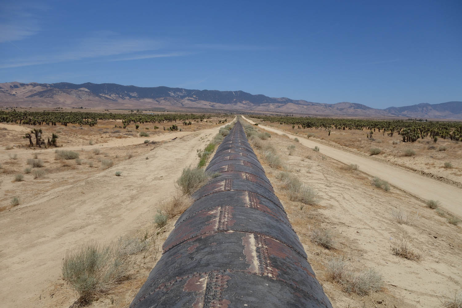
Along here we also got to see several different types of aqueducts. There were sections with a flat concrete top, older sections covered in curved concrete ribs –the standard before someone figured out you could use the top of the aqueduct as an access road if you flattened it –and even a mile-long section of above-ground pipe, built from massive 12-foot-diameter rounds brought in by mule teams.
At State Route 138, we stopped at the Neenach Cafe and Market for a cold drink. From there, we rode tarmac into the foothills, through the towns of Lake Hughes and Elizabeth Lake, past the legendary motorcycle stop The Rock Inn and into Green Valley and San Francisquito Canyon.

It was in this canyon that William Mulholland and the brain trust behind the mighty aqueduct decreed that Los Angeles’ water should be stored. A concrete gravity dam –virtually identical to the Mulholland Dam that still holds up Lake Hollywood –was constructed in a narrow section of the canyon. The St. Francis Dam was completed in 1926. Two years later, and only hours after Mulholland had inspected the dam and deemed it safe and stable, the structure gave way.
Just before midnight on March 12, 1928, a wall of water 180 feet high surged down the canyon. More than 12 billion gallons of water left the dam within the next hour. Entire communities were engulfed and swept away. At least 431 lives, and perhaps many more, were lost.

We rode our Pan Americas along a dirt path toward the original dam site. Beside the trail were massive chunks of concrete, some as big as a Winnebago, remnants of the fallen structure. Returning to the road, we continued down the canyon to Power Plant 2, where aqueduct water runs through turbines to create electricity. We’d only intended to admire the exterior of the building. But a building superintendent, noticing our bikes in the parking lot, let us in for an impromptu tour of the remarkable facility, which still uses the same turbines that were installed more than a hundred years ago –some of them recovered after the disaster from miles down the canyon.
Our interest wasn’t only in the disaster. There was a motorcycling purpose to our visit, too. The last person to see the dam before it blew was a motorcyclist named Ace Hopewell, who heard rumblings above the noise of his engine and stopped to listen before riding on.
There were motorcycle heroes, too. State Motorcycle Officer Thornton Edwards and Santa Paula Police Officer Stanley Baker were notified of the dam’s collapse, and at great risk to themselves raced from street to street in Santa Paula sounding the alarm. The two riders are credited with saving hundreds of lives, as the people they woke from sleep were able to escape being swept away by the rushing waters.

To pay tribute to these men, we rode south from Power Plant 2, across Castaic, past Magic Mountain, along the part of State Route 126 that was once home to the motocross track known as Indian Dunes, and into the town of Santa Paula. To fortify ourselves we stopped at Rabalais’ Bistro for strong coffee, hot beignets, and plates of gumbo, red beans and rice with andouille sausage, and shrimp and grits.
At sunset, we stood near the old Santa Paula train station and admired local artist Eric Richards’ metalwork statue entitled “The Warning.” It depicts the two valiant motorcycle officers, one astride an Indian and the other a Harley, as they made their rounds that deadly night. As dark began to suggest itself in Santa Paula, we headed back, making as quick a trip as possible on pavement to return to our starting point. We’d ridden 180 miles to get to the statue of the two heroes, 50 of that on sandy aqueduct. It took us 100 miles of high-speed pavement to get back to Zakar.
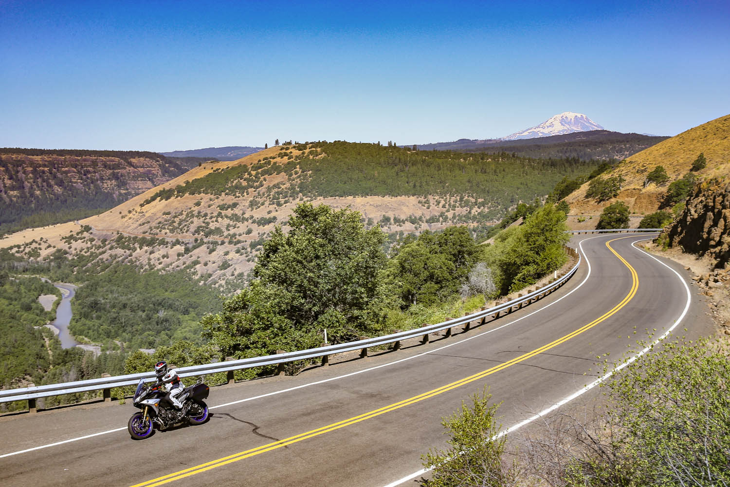
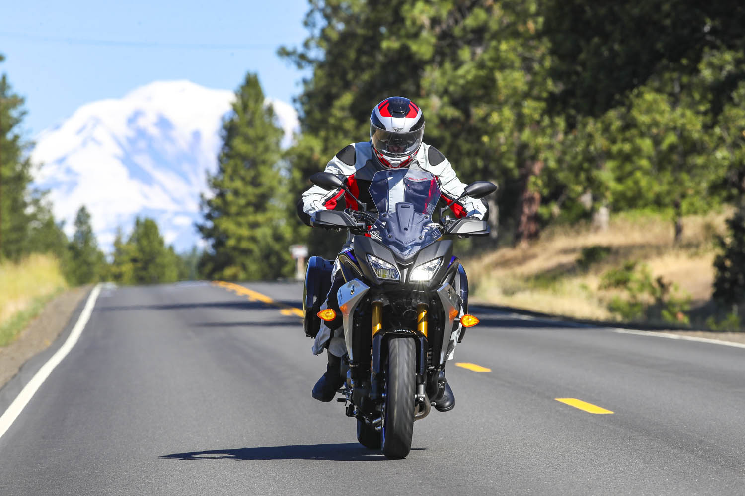
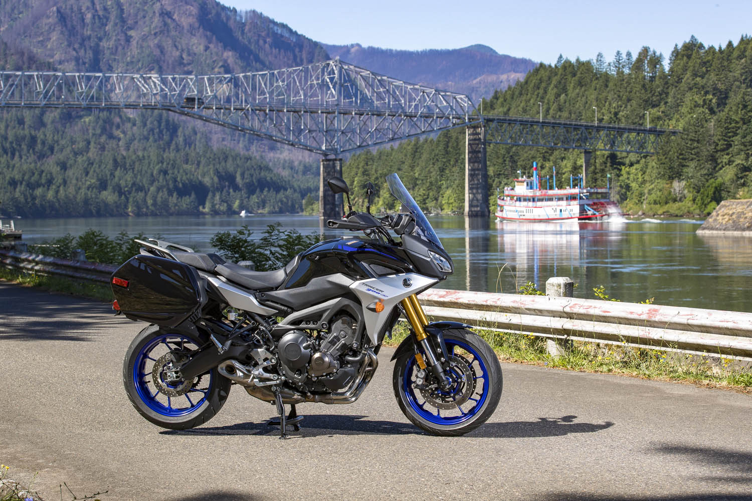
Tracing the Cascades on a Yamaha Tracer 900 GT
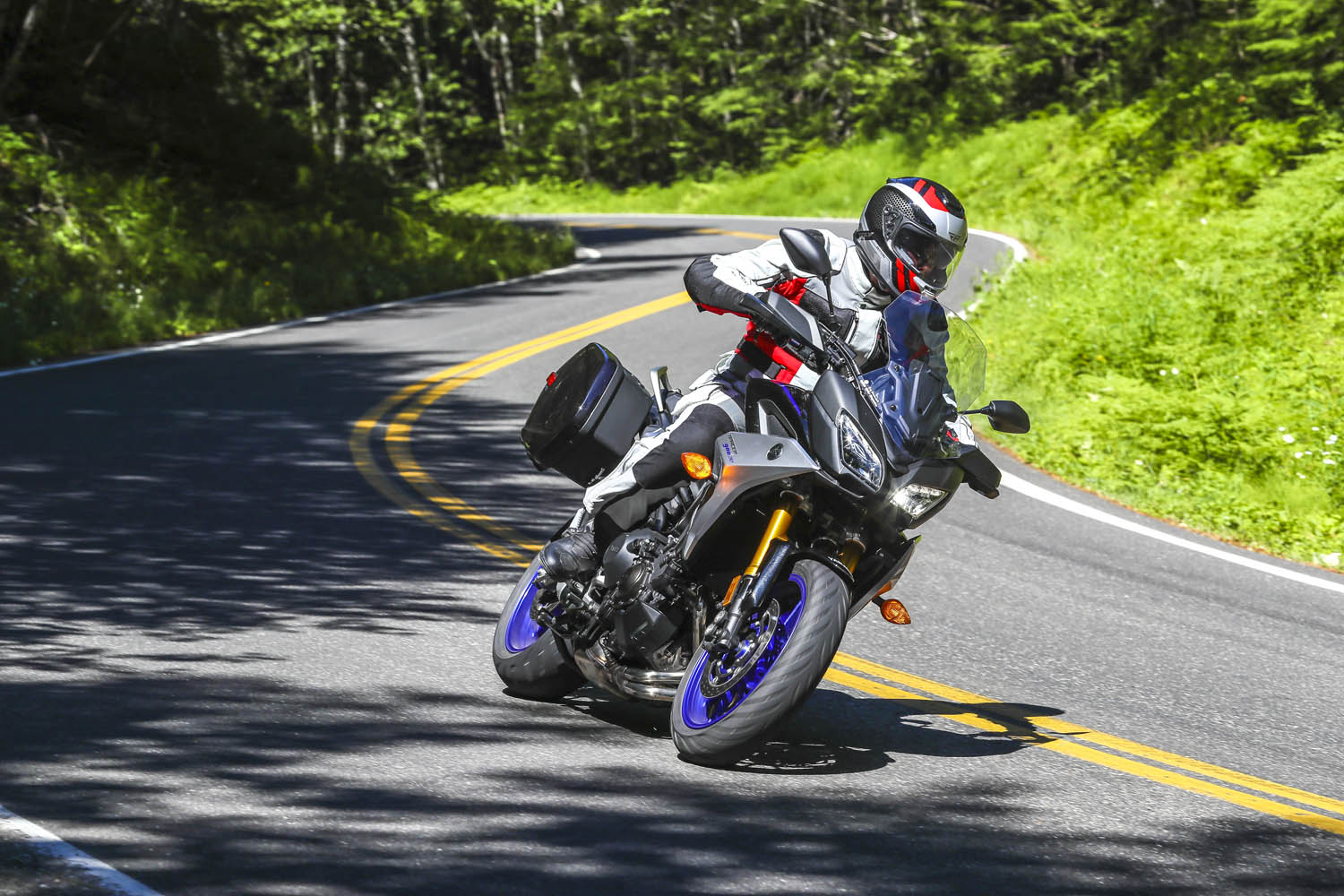
Winding through a dark canopy of evergreens, the road played hide-and-seek with the Clackamas River, offering a glimpse here and there of clear water pouring over rocks as it made its way downstream to the Willamette, then the Columbia, and finally the Pacific. A break in the canopy was like popping out of a tunnel and I set my eyes on a patch of gravel next to the road, just a few feet from where the river made a sharp turn. Down went the Yamaha Tracer 900 GT kickstand, off went the ignition. I hadn’t seen a car for miles. It was just me and the trees and the river. Just what I was looking for.

The previous day I logged 250 miles aboard the Yamaha at the bike’s press launch. The event was based in Stevenson, Washington, a small town in the heart of the Columbia River Gorge National Scenic Area, and I spent a long, hot day testing the GT on local backroads. Weighing just 500 pounds and packing a punch from its 847cc inline-Triple, the Tracer 900 GT is a light, agile, comfortable sport-tourer, perfect for a solo traveler. Yamaha entrusted me with the keys to one for the long ride home to Southern California.
For years I’ve heard and read about how good the riding is in the Cascades, a mountain range that runs from British Columbia down through Washington and Oregon to Northern California. Whenever possible, I like to fill in the blank spots on my mental map –to experience first-hand what roads and scenery are really like. So I sketched out a route from the Columbia River to the California border that zigzags several times over the Cascades, winds its way through four national forests and one national park, and follows three designated scenic byways. Like any good motorcycle route, it would take at least twice as long as a more direct path.

Click here to view the route above on the REVER app/website
With the GT’s saddlebags packed and a tailbag strapped to the passenger seat, I hit the road at 6 a.m., crossing the mighty Columbia – and into Oregon – on the Bridge of the Gods, a steel truss bridge named after a natural dam that was created by a landslide at the same location nearly 1,000 years ago. The narrow, 90-year-old bridge has no pedestrian walkway, but it’s where the Pacific Crest Trail crosses the river, so weary hikers with heavy packs must contend with cars and trucks.
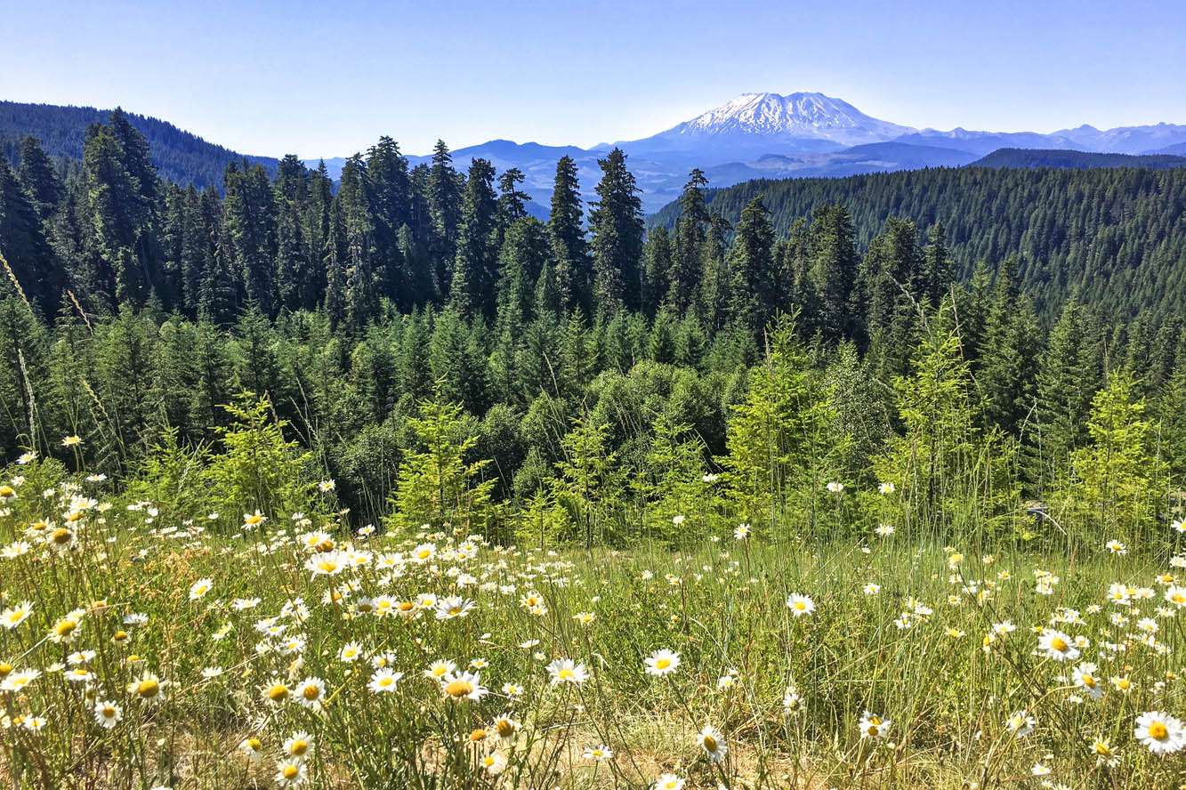
What makes the Cascades special is its many stratovolcanoes –the cone-shaped variety we learned about in grade school –that rise thousands of feet above the surrounding mountains. I’ve ridden along the eastern side of the Sierra Nevada in California dozens of times, and every time I pass through the town of Lone Pine, I struggle to pick out Mount Whitney – the tallest mountain in the lower 48 states – from the neighboring peaks that are nearly as tall. On the Tracer 900 GT press ride we saw several volcanic peaks, Mount Adams (12,281 feet) and Mount St. Helens (8,363 feet – before it blew its top in 1980, it was 1,300 feet taller) in Washington, and Mount Hood (11,249 feet) in Oregon, standing head and shoulders above the landscape, easily visible from miles away. They’re part of the Cascade Volcanic Arc, a series of 12 volcanoes stretching from Mount Silverthorne in British Columbia to Mount Lassen in California, which is part of the Pacific Ring of Fire –more than 450 volcanoes scattered along the outer edge of the Pacific Ocean.
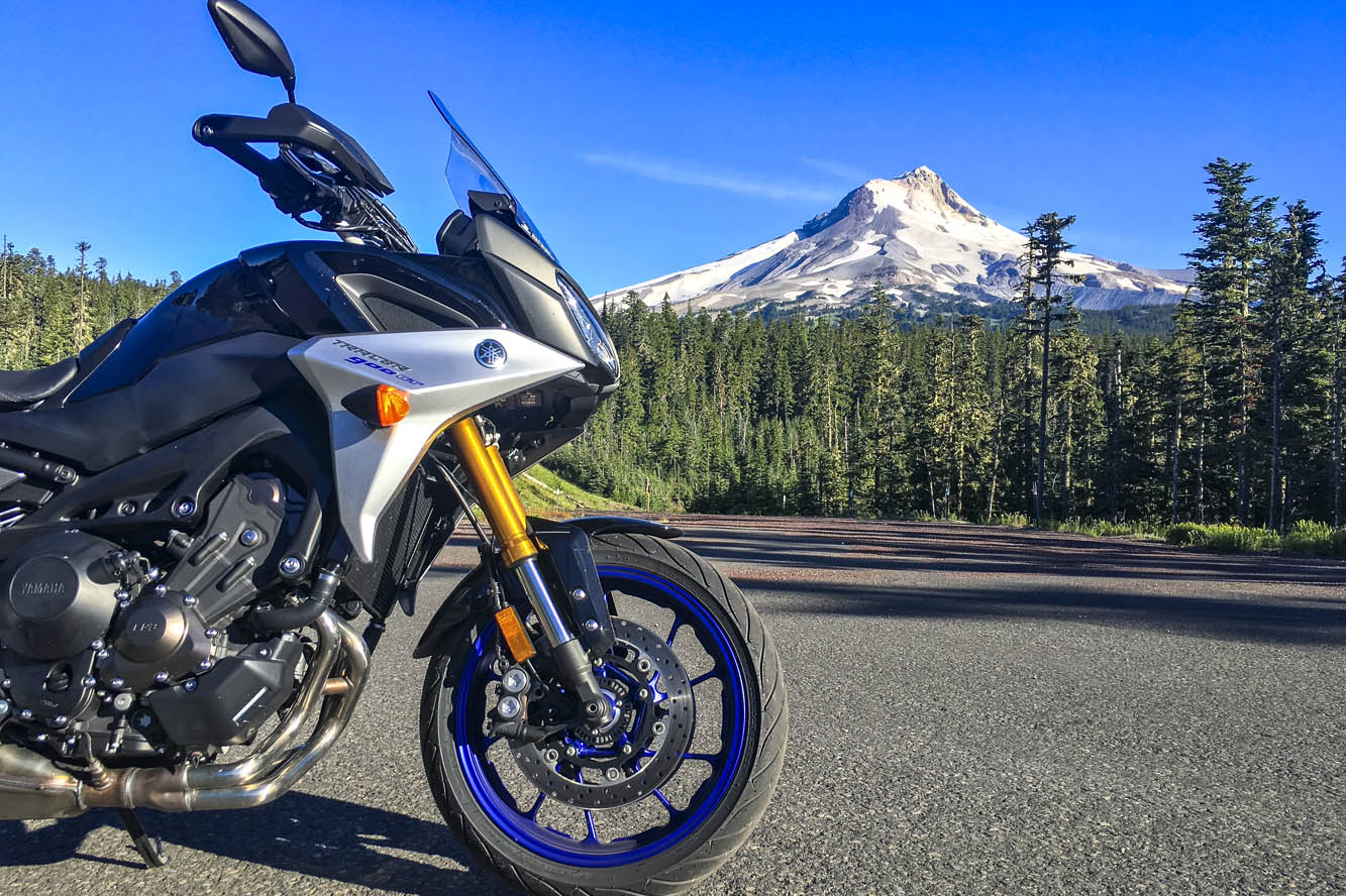
Like a good omen, snow-covered Mount Hood greeted me as I turned south on State Route 35, the beginning of Mount Hood Scenic Byway, where I rode through apple farms on a sunny, cloudless July morning. The previous day topped out at 105 degrees, and the heat wave wasn’t done with me, but early in the morning the byway along the East Fork Hood River was still in deep shadow and my teeth began to chatter. On went the heated grips, and I tried to hold onto the physical memory ofbeing cold, hoping to recall that feeling during theheat of the day (it never works). With graceful curves and smooth pavement, the byway is a pleasure to ride, especially when the screen of trees falls away and Mount Hood takes center stage, framed perfectly in brilliant blue.

After cutting a wide arc around the eastern and southern sides of Mount Hood, my first crossing of the Cascades came to an end in Sandy. Turning south and then east on State Routes 211 and 224, I picked up the West Cascades Scenic Byway, heading southeast along Estacada Lake and North Fork Reservoir, two finger lakes created by dams on lower sections of the Clackamas River. As the byway crosses into Mount Hood National Forest, it enters a deep, narrow valley as it climbs up into the Cascades, where the Clackamas flows wild and free. The Tracer and I were in a groove, experiencing this road together for the first time –bends, kinks, dips, rises, bridges, blind corners, and fleeting views of the river, the contours of which give the road its character.
With the low-fuel light on, I pulled into Detroit, a crossroads on the shore of Detroit Lake. Folks were starting their summer weekend early. Subarus laden with kayaks and pickups overflowing with camping gear were parked in lots, coolers were being filled with ice and beer. I refueled and scarfed an egg salad sandwich in the shadow of Rivers Run Deli, trying to stay cool while enjoying a view of the marina and the lake’s milky blue water. When traveling solo and covering a lot of miles in just a few days, I rarely stop for long. Just a few minutes here and there, then I’m back in the saddle, trying to cram 10 pounds of riding into a 5-pound sack.
From Detroit to Chemult – south, zig west, zag east, back over the Cascades –all I remember are trees, and a cross-section of America. Stopping to use the bathroom at a McDonald’s, I had to negotiate my way through a crowd of boisterous kids wearing matching blue T-shirts bearing the name of their church summer camp, ready to fill their bellies with Happy Meals. Outside, two young women were sitting on the curb, holding a sign: Family in Need. And next door I topped off the Tracer’s tank after the flirtatious – not to mention bald and tattooed – gas station attendant handed me the nozzle. (In Oregon and New Jersey, you’re not allowed to pump your own gas, but attendants often let motorcyclists break the law.) I was just passing through, little more than an observer. Experiences like these give me something to mentally chew on while ticking off miles.
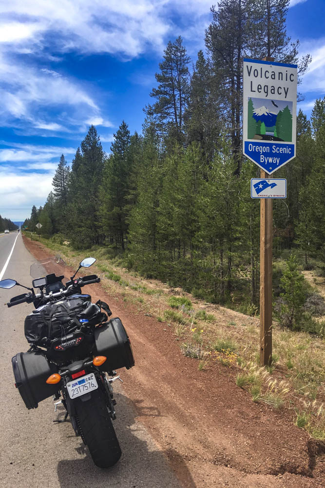
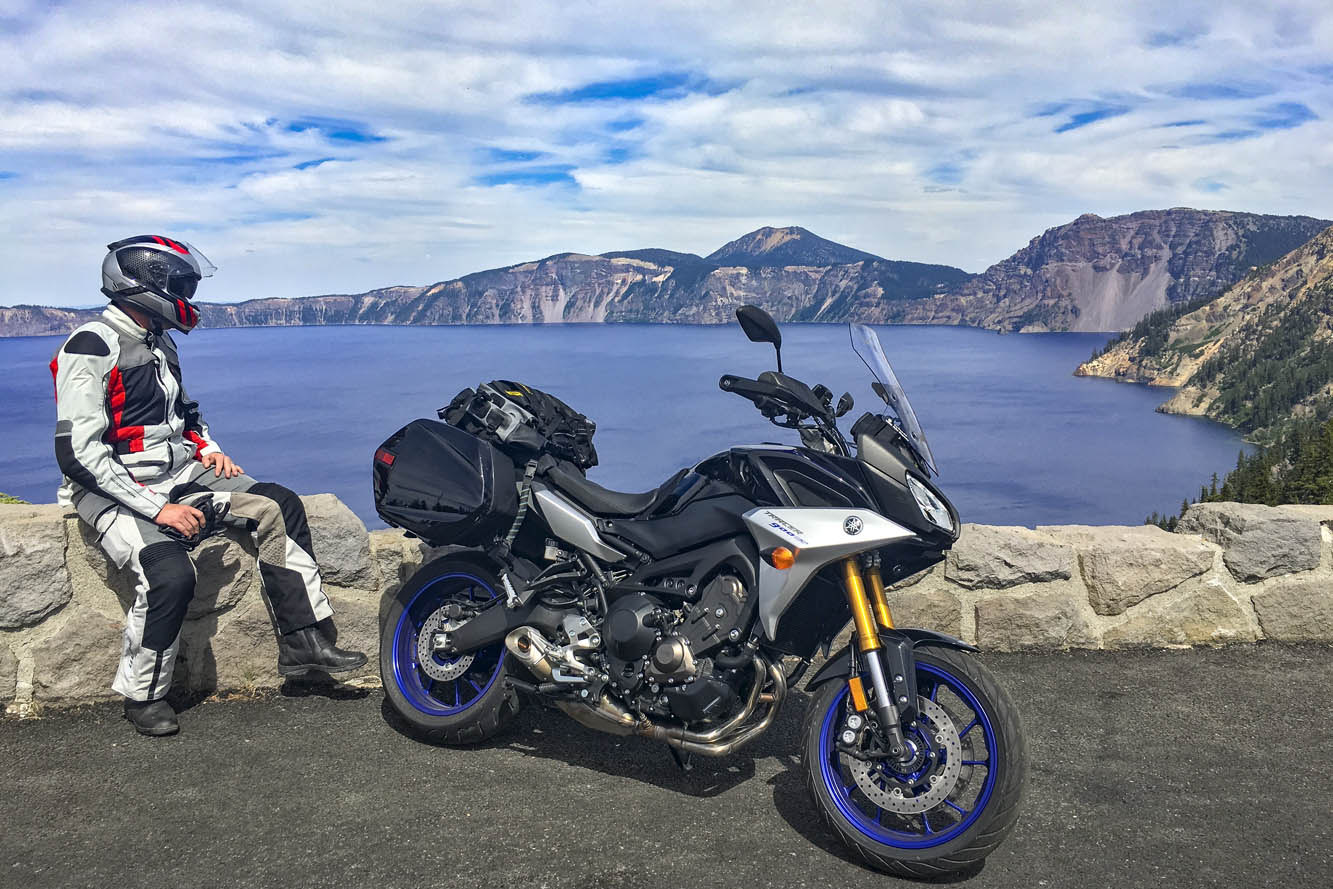
Passing through Chemult, a truck stop on U.S. Route 97 brought back memories of stopping there to refuel during my one and only SaddleSore 1000 ride back in 2013 – a very long day that I’m not likely to repeat. Turning west on State Route 138, the Volcanic Legacy Scenic Byway took me to Crater Lake National Park, where I queued up behind a rumbling Harley and a line of cars and RVs outside the northern gate, keeping my faceshield closed to prevent the army of mosquitos from waging war on my nose. Crater Lake was high on my list of must-see places, and it didn’t disappoint. Created thousands of years ago when a volcano collapsed, the caldera lake is nearly 2,000 feet deep – the deepest in the U.S. – and because it is filled only by rain and snow, the water is pure and a brilliant shade of blue. But I was pressed for time and there were construction delays on the East Rim Road, so I’ll have to go back to ride the full loop.
On the not-politically-correct but wonderfully twisty Dead Indian Road, I descended from the green heaven of the Cascades into the dry, brown hell of Ashland. It’s actually a lovely little town, home to Southern Oregon University and the world-famous Oregon Shakespeare Festival, but it was over 100 degrees and I had been in the saddle for 12 hours. I was in desperate need of a cold shower, a colder beer, and some pizza.
The next day I left the Cascades, riding a few miles south on Interstate 5 into California, where I filled up at a Chevron in Hornbrook. On both sides of the interstate and all around the gas station, the ground and vegetation were charred black from the Klamathon Fire, which roared through just days earlier. It was one of many wildfires that would plague California and other western states in the weeks and months ahead.
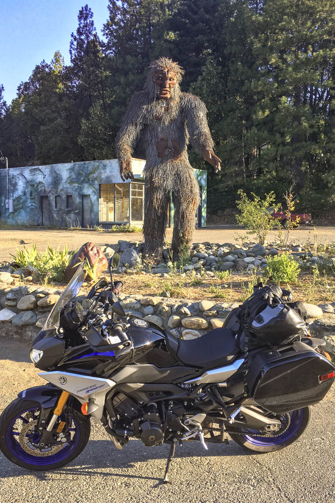
More blanks filled in on my mental map: State Route 96 along the Klamath and Trinity rivers, which cuts through rugged, remote country. In 1941, a group of armed men stopped traffic near the town of Yreka, handing out a Proclamation of Independence for the State of Jefferson, which was in “patriotic rebellion against the States of California and Oregon.” Although the new state never materialized, the movement is still active, and the State of Jefferson Scenic Byway runs along Route 96 from State Route 263 to Happy Camp. After that, 96 becomes the Bigfoot Scenic Byway. Regardless of one’s views on state politics or mythical forest dwellers, the riding along Route 96 is sublime and traffic is almost nonexistent.
At Willow Creek, I turned west onto State Route 299, known as the Trinity Heritage Scenic Byway because it follows the path of 19th-century gold miners and pioneers. It snakes its way through the heavily wooded Trinity Alps and climbs over a pass before making a long descent to the coast. Even in mid-July, U.S. Route 101 through Arcata, Eureka, and Fortuna was socked in with chilly fog. At Alton, I turned east again, heading inland on State Route 36 –not a designated scenic byway, but known as Serpent to the Sea. Traveling west-to-east, it passes through a few rural communities before entering Grizzly Creek Redwoods State Park, where enormous coast redwoods rise hundreds of feet above the roadside.
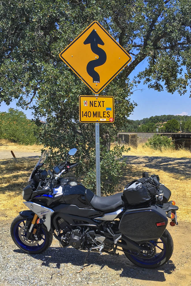
Beyond Bridgeville, Route 36 turns into a narrow goat path as it goes over a ridge, but it’s currently being straightened and widened to accommodate big trucks and RVs –an improvement for them but not for motorcyclists. East of Dinsmore, Route 36 was freshly paved, like having a racetrack all to myself, scraping the Tracer’s peg feelers in corner after corner. And on it goes, over more mountains with endless curves and finally roller-coastering its way through ranch land with blind crests and sudden drops and quick turns. As I approached the town of Red Bluff, just before Route 36 crosses I-5, I found the well-known sign that warns motorists and entices motorcyclists: curvy roads next 140 miles.
The thing about riding roads as good as these is that it becomes addictive. Now that I have experienced the Cascades and California Routes 96 and 36 for myself, all I want to do is go back for more.
The post Tracing the Cascades on a Yamaha Tracer 900 GT first appeared on Rider Magazine.14 Best Soul Food Restaurants Around Atlanta

What’s the difference between soul food and Southern food? The phrase “soul food” was first coined in the 1960s, seemingly meant to describe the honest-to-goodness, comforting foods often prepared at home by African American Southerners, with many dishes rooted in survival and the African diaspora. This food is soothing, good for the spirit, and just one category of fare falling under the broader umbrella of “Southern” food. Atlanta has no shortage of great restaurants that identify cuisine served on the menu as soul food. Here are some of the best restaurants to try around town.

In this latest update, Ms. Iceys Kitchen and Bar was removed because it is temporarily closed. The restaurants are listed geographically from south to north. Don’t see a favorite soul food restaurant listed? Email Eater Atlanta with suggestions to check out for the next update via the tipline.
BBQ Spaghetti: A True Memphis Original
Barbecue spaghetti is a signature Memphis dish that you're not likely to find anywhere else. Our recipe is simple to make and a great way to incorporate extra pulled pork into a delightful side dish or even a full meal.
The post BBQ Spaghetti: A True Memphis Original appeared first on Meathead's AmazingRibs.com.
Meet Triumph’s First All-Electric Motorcycle

Persol 3269S Sunglasses

Visit Uncrate for the full post.
Singer's latest reimagined Porsche 911 is the 930 Turbo perfected - Roadshow

Belgian Squirrel – Guide to Cooking Game
Belgian Squirrel Ingredients (Serves 6): 1/2 cup unsalted butter 3 large squirrels 9Skinned, cleaned and de-boned; use hind legs and meaty back; cut into serving pieces) 2 white onions, peeled and sliced 3 tablespoons white vinegar 1/8 teaspoon dried thyme Salt and black pepper, to taste 18 pitted prunes 1 1/2 teaspoons all-purpose flour…
The post Belgian Squirrel – Guide to Cooking Game appeared first on Sporting Classics Daily.
Bengals Fans Are Shotgunning Skyline Chili—Which Gives Us an Idea

NFL fans are some of the most passionate sports fans in America. Just ask The Takeout’s favorite tailgater, Pinto Ron. Well, a small population of Cincinnati Bengals fans are really showing their fan dedication when it comes to their team, because some of them have been chugging cans of hometown favorite’s Skyline…