Shared posts

12 Apr 23:42

Tesla’s parking lot is a nightmare hellscape.

by Nathanael Johnson

Elon Musk, the company’s celebrated chief executive, has convinced investors that he’s building the electric cars of our future. But he has yet to tackle the stubborn problem left over from the 20th century: Parking sucks. If you need any convincing, consider this snapshot from Tesla’s overcrowded parking lot.

Instagram Photo

That’s from an Instagram account documenting the madness.

You might think Tesla could try to fix its problem with self-driving cars that ferry people to work then park themselves in a faraway lot. But that really doesn’t solve the parking problem so much as relocate it. The fact is, no matter how green and smart you make them, cars still hog big swathes of valuable land.

Instagram Photo

So, sure, let’s hope for a future full of electric cars. But maybe we should also experiment with something truly disruptive, like making it easier for developers to build dense housing near offices, thereby giving employees the choice of walking to work. Pedestrians don’t squabble over parking spots.

This story was originally published by Grist with the headline Tesla’s parking lot is a nightmare hellscape. on Apr 12, 2017.

12 Apr 18:24

A Church Cookbook Might Be the Best Greek Cookbook Around — It's Greek to Me

by Meghan Splawn

Church cookbooks were once so common, they were considered unremarkable. Living in the South, I know the scene well — Ladies League recipe pamphlets and community cookbooks litter the shelves of thrift stores. Yet the best food writers seek these records out, both as a means of preservation and as a way to gain insight on recipes that truly tell the stories of regional foodways and the cuisines of other cultures.

So I shouldn't have been surprised when, in researching Greek recipes for tzatziki, Greek dressing, and Greek salad, I found that a Church cookbook would be one of the most recommended, well-loved, and trusted resources. The Complete Book of Greek Cooking by the Recipe Club of Saint Paul's Greek Orthodox Cathedral is a compilation of two previous best-sellers with a rich history of over 50 years of women cooking and recording the recipes of their heritage.

READ MORE »

12 Apr 16:03

IKEA Hacks IKEA for Milan Design Week 2017

Who makes the best IKEA hacks? After last week's IKEA Festival during Milan's Design Week, the clear winner is IKEA. For their first official foray into presenting during the festivities of Salone del Mobile (2015's kitchen-focused presentation in Tortona was also meant to address the throngs of visitors for Expo Milan), IKEA did it big, taking over a huge warehouse in Ventura Lambrate with multiple vignettes curated by influencers like designer Faye Toogood, the editors of OpenHouse, and interior stylists Anna & Pella, as well as daily programming, live art, product debuts and of course, meatballs. 

Faye Toogood had a great showing in Milan and her installation for IKEA was a platform to showcase her signature affinity for white paint and theatrical approach—collapsing scale, dimension and surface in whimsical and unexpected arrangements of interior objects. 

"Enfant Terrible" repurposed beloved IKEA classics into a wonderland of mismatched furniture replete with an adult-friendly slide, and an oversized couch plucked from Pee-Wee's to populate Faye's Playhouse.

YPPERLIG Chairs designed by HAY for IKEA.

But perhaps the most understated but most anticipated of the festival's goings-on was the debut of two highly anticipated designer collaborations—the YPPERLIG collection by Hay and the DELAKTIG by Tom Dixon. YPPERLIG was teased last year with an abstract film jointly released by the companies that contained no reference to actual pieces of furniture but alluded to a mood that might guide the collection. Chairs from the yet-to-released collection were some of the most enviable products on display.

DELAKTIG by Tom Dixon for IKEA.

Similarly, the DELAKTIG was designed to address the increasing expectations from the modern city-dweller of the products that populate their life. Designed for "hacking," the DELAKTIG is a daybed of sorts, what IKEA calls, "an open platform for social living," that can work as a primary couch, a guest bed, in the corner of a room or as a centerpiece with infinite possibilities for add-ons on its steel frame. As Dixon told The New York Times in an interview about the collaboration, "It's very much something that can mutate according to your changing conditions. You could put on a lamp, a phone charger, a side table. You could raise or lower it, or put it on wheels. It can easily go from being a student bed to a really posh couch, and then back again when you have kids."

More scenes from 2017's IKEA Festival at Milan Design Week

Painting Robot plotting to take over the world.
Painting robot in action.
Soft seating IKEA Hack
Soft Spot main stage for programming encouraged a lot of lounging.
SPACE10, IKEA's living lab in Copenhagen, prototyped an open-source garden pavilion.
New rug collection.
Small vignettes curated by Anna & Pella featured artisans working in the space. 
Tailor working in an Anna & Pella vignette.
Painter working in an Anna & Pella vignette.
10 Apr 17:11

Existential Bug Reports

ISSUE: If we wait long enough, the Earth will eventually be consumed by the Sun. WORKAROUND: None.
06 Apr 16:30

When Common Sense is Wrong, and Intuitions Fail

by Zach Shaner

Bike lanes are clearly the problem. (5th Avenue, SounderBruce, Flickr)

A recent blog post by well-respected local meteorologist Cliff Mass, “Fixing Seattle’s Traffic Mess,” offered an anti-urbanist grab bag of bad ideas. Bemoaning the current state of traffic, Mass distills Seattle’s traffic woes to 9 problems:

  • Road diets that “promote congestion and substantially reduce maximum throughput”
  • Poor road conditions resulting from “Seattle Council members paying [less] attention to the traffic-producing bad roads than kayaking out to oil platforms destined for Alaska”
  • Excessive draw bridge openings
  • Sounder is too unreliable, and the trains are “less than half full”
  • Distracted driving 
  • Link serves the Rainier Valley: “It takes forever to travel that segment and sometimes the trains get into accidents with cars.”
  • Undersupplied parking at Link stations: “Folks need a place to park if they are going to use the train”
  • Bike lanes: “The only safe way to commute is to be totally separate from cars, not the side lanes of the “road diet” streets”
  • Continuing lack of bus service

Many local outlets piled on the criticism, including The Strangerbut I see no reason to single out Mr. Mass. His assertions are widely held, intuitive, and derived from common sense. They are also completely unsupported by data.

To wit, road diets haven’t greatly increased travel time or reduced throughput, drawbridges must open by Coast Guard mandate, Sounder is 95% reliable and carries 500 passengers per trip, Sounder mudslides have gone down markedly due to intensive work by WSDOT, a Duwamish Bypass for Link would cost $1B and only save 3-4 minutes, transit parking is a niche product that cannot scale, and our local and regional bus service levels are at historic highs.

Just as Mass’ diagnostic skills are lacking in his post, so too are his 3 prescriptions: passenger ferries, flexible app-based carpooling, and a Big Data approach to signal timing, etc. Perfectly reasonable sentiments, but none of them remotely sustainable. To the extent that app-based carpooling diluted transit ridership, it would make things worse. While Big Data can optimize flow at the margins, the fundamental use-of-space problem is immutable. And when it comes to passenger ferries on Lake Washington, King County’s official report showed that they would suffer from low ridership and would incur costs three times higher than Sounder.

Collisions Down, Traffic and Travel Times Flat. Road Diets Work.

From the Q4 2016 Ridership Report

But if you’re stuck behind the wheel, it’s reasonable that you’d think “two lanes would be better than one”. Link’s Rainier Valley deviation feels slow, even when it only costs a couple minutes for people like Mr. Mass who likely view it as an airport shuttle. If you would love to ditch your car but the park and ride is full,  you’ll wish there were more spots. In each of these cases, people’s lived experience contradicts what the data clearly says. Accordingly, we should cut such folks some slack, and do a better job of showing our work.

If you drive everywhere, it may well look like madness, and Seattle’s urbanist policies are a visible and convenient foil. But if bike lanes et al were to blame for traffic, you wouldn’t expect traffic problems in car-focused places such as Kennydale Hill, the Fife Curve, or Joint Base Lewis McChord. But we know that each of those places are equally choked by traffic. So if you find yourself thinking, without irony, “Nobody goes there anymore, it’s too crowded,” it’s time to take a step back and learn to distrust your intuitions. It’s hard to get things right, especially outside one’s area of expertise. Mistakes are acceptable, but we shouldn’t assert without evidence.

05 Apr 22:36

Cherry blossoms are just one more sign our planet is out of whack.

by Kate Yoder

You don’t need fancy equipment to see that the climate is changing. Sometimes, it’s as simple as observing what’s happening outside, keeping track of when the cherry trees bloom year after year.

In Kyoto, Japan, people have been doing just that for more than 1,000 years. The trees used to bloom like clockwork around April 17 each year — until 1850, when warming temperatures started to push the flowering date earlier and earlier to its current average, April 6.

Cherry blossoms on the other side of the globe, in Washington, D.C., tell a similar tale. Since 1921, when the National Park Service began keeping records, peak bloom has moved back five days.

Spring weather has become more erratic, too, leaving these early blooms susceptible to cold snaps. This year, late spring frost killed off 50 percent of the blooms of one cherry variety in D.C.

You could say that their untimely arrival was … not so pretty in pink.

This story was originally published by Grist with the headline Cherry blossoms are just one more sign our planet is out of whack. on Apr 5, 2017.

04 Apr 21:06

The Ultimate 2016 Presidential Election Map?

by Andrew Small

If you’ve been following CityLab since November 8, you’ve seen a lot of U.S. presidential election maps. But this new one is a little different. It came to our attention via Twitter exchange between economist Jed Kolko and our own Richard Florida.

Yes, it is very red, we don’t need to remind you. But zoom in a bit closer and you’ll find that there’s a lot more to love about this Decision Desk HQ production from scrappy amateur cartographer Ryne Rhola: It’s a precinct map, a gloriously granular glimpse into our divided nation’s voting proclivities, at the nearly neighborhood level.

Rhola, a fourth year Ph.D. student in Economics at Washington State University, has been building maps since before he was out of high school. He started building election maps in 2008, using MS Paint, of all things.

The 2008 election, not made using MS Paint. (Ryne Rhola/Decision Desk HQ)

On the eve of the 2012 election, Stanford’s Spatial Social Science Lab had published a precinct-level map for 2008; Rhola had considered making a 2012 map but abandoned the idea given the enormity of the task.

The 2012 election, mapped by precinct. (Ryne Rhola/Decision Desk HQ)

Once 2016 rolled around, Rhola decided to go for it. He started compiling precinct data as soon as the election was over. But gathering those returns at the precinct level is not nearly as easy as the county level data we are accustomed to hearing about. Rhola sometimes had to track down precinct vote counts by calling county clerks and secretaries of state.

The 2016 election by precinct. (Ryne Rhola/Decision Desk HQ)

“I tried to do everything I could online,” Rhola tells CityLab. “But there are a lot of places that didn’t have the ability to do that. Maybe they didn’t have an office scanner or an email address available. I would call them up and ask for the information.”

Rhola’s map-making adventure also required him to negotiate state-by-state election laws—for example, he had to file Freedom of Information Act requests to get results in New York and New Jersey. But he also talked with passionate people along the way. “One guy who was really interested in my research was a county clerk in Missouri—he  wanted to know all it,” he says. “But most of the time, it was a quick email or fax or mail. In a few cases I had to pay a fair amount of money to get them.”

Once that was done, he just had to map out the precincts. Easier said than done.

Screenshot of New York City’s surrounding areas (Ryne Rhola/Screenshot by CityLab)

“States don’t publish a complete precinct file very often,” Rhola says. “I could try to update from current state files, but sometimes I had get an actual physical copy of the precinct map. I even had to go in person to get some of this information.”

Rhola also used 2012 voting data to better show the vote swings at the precinct level. The map below shows the change in percentage for different districts, with red and pink indicating a percentage shift towards Trump and light blue and dark blue indicating a shift towards Clinton. The story it tells is clear: “This is the most urbanized election that we've had,” Rhola says. “The inner suburbs swung towards Clinton, and the outer suburbs behaved more like rural areas. You can really tell the outlying of cities now based on the vote.”

Vote swing by precinct in New York City and its surrounding area. (Ryne Rhola/Screenshot by CityLab)

Getting a map like this to the public, Rhola thinks, could help people understand the country better. “It makes things seem a bit less dichotomous,” he says. “You can understand that there are more places near you that think differently than you see from a state or county map.”

The map also reveals heretofore hidden details, such as clusters of third-party voters. “In Utah, [Evan] McMullin pulled off a majority in a precinct or two,” Rhola says. “Mostly around colleges. There were also a few places where Gary Johnson or Jill Stein might be in the majority.”

A screenshot from the interactive version of the map in Salt Lake City, where one precinct with 36 votes went 41.68 percent to McMullin. (Ryne Rhola/Screenshot by CityLab)

Unfortunately, you may have to wait patiently to dive fully into the details. At the time of this writing, the server for the map had crashed, likely from the outpouring of interest from map-happy urbanists. Maybe pony up a donation or two and get the guy some server space!

If you can’t get in there to interact with the map yet, we’ll leave you with a few details of how various urban regions voted.

04 Apr 00:43

How A Little Metadata Made It Possible To Find FBI Director James Comey's Secret Twitter Account

by Mike Masnick

For a few years now, our intelligence overseers have been insisting that we shouldn't be too concerned about surveillance programs that collect "just metadata" because that doesn't really reveal too much. But, of course, we've shown how "just metadata" can ruin a career diplomat's life, and former NSA/CIA boss Michael Hayden has admitted that the US kills people based on metadata.

Either way, I find it fascinating that reporter Ashley Feinberg needed just a few small bits of innocent metadata from FBI Director James Comey to track down his secret Twitter account. It took her all of four hours or so. Just last night, Comey admitted that he was on Twitter, leading lots of people to go searching for the account since there is no official one. I won't describe all of how Feinberg tracked it down (it involves some pretty excellent sleuthing and is worth reading) but suffice it to say, it's metadata that gives Comey away. The account, @projectexile7, was then almost certainly confirmed as Comey's based on metadata about who was following it, who it was following, and what it liked:

But how to be sure? There is only one person currently following the account: Benjamin Wittes of Lawfare. Wittes is no Twitter neophyte. He is an active user with more than 25,000 followers, and he only follows 1,178 accounts—meaning he is not a subscriber to the “followback” philosophy. If he is following a random egg—and is the only account following it—there is probably a reason.

That reason could be the fact that, as Wittes wrote here, he is a personal friend of James Comey. (We’ve reached out to Wittes for comment but have yet to hear back.)

Project Exile happens to be a federal program that James Comey helped develop when he was a U.S. attorney living in Richmond. And then, of course, there are the follows.

ProjectExile7 follows 27 other accounts, the majority of which are either reporters, news outlets, or official government and law enforcement accounts. The New York Times' Adam Goldman and David Sanger and the Washington Post's Ellen Nakashima and David Ignatius, all of whom have been aggressively covering the FBI investigation into Trump’s contacts with Russian agents, made the list, as did Wittes and former Bush Administration colleague Jack Goldsmith. Donald Trump is on there, too, but @projectexile7 seems to have begun following him relatively recently (its first follow was @nytimes).

There are two outliers: William & Mary News (where Comey attended undergrad) and our colleagues at The Onion (everyone deserves to have fun)

And, yes, I do find it hilarious that Ben Wittes — among the loudest cheerleaders for programs that scoop up metadata — is part of the reason the account was recognized as Comey's.

Go read the full article by Feinberg. Of course, I doubt it will change Comey's views on "just metadata", but it is yet another representation of how powerful a little bit of such data can be in tracking someone down.


Permalink | Comments | Email This Story
21 Mar 21:52

Are Women Really More Risk-Averse on Bikes, or Just More Honest?

by Michael Andersen, PlacesForBikes
Chicago, Illinois.
Chicago, Illinois.

There’s a widespread belief in the biking world that one reason to build comfortable bike infrastructure is that if streets are safer, more women will bike. Women are, as one saying has it, an “indicator species” for good biking. Join protected bike lanes, off-street paths and side-street bike boulevards into a network and one mark of success will be that allegedly risk-averse women will start to ride in larger numbers.

Here’s one key bit of evidence for this belief: if you ask, women are often more likely to say they prefer comfortable bike infrastructure, depending on the exact question. For example, here’s a survey of people biking in recently constructed protected bike lanes in six cities. In every case, women were at least somewhat more likely to say they had increased their biking in general due to the presence of protected bike lanes:

Interestingly, though, when researchers asked more specific questions such as “do you bike on this street more often?” the gender differences vanished.

Studies don’t confirm that women are actually much less risk-averse than men while biking

A different study co-authored by one of the same researchers (Jennifer Dill of Portland State University) used GPS devices to track the actual behavior of men and women — and found much less variation between the genders. Working with her co-author John Gliebe, Dill measured the difference between the shortest possible path for a trip and the actual path, essentially calculating how far people were willing to go out of their way to use various types of bikeways. There were slight differences between the genders, but nothing dramatic or even particularly consistent.

Another argument you’ll hear in favor of the “women are an indicator species” theory: Cities with more bicycling also tend to have more gender parity. Below are a handful of U.S. cities that have put significant effort into bike infrastructure. The number in parentheses is the percentage of commutes by city residents that happen by bike; the bars indicate the gender split among bike commuters.

Data: American Community Survey.

There is definitely a trend here, but look more closely and you’ll see flaws too. Why are D.C. and New Orleans so much more female-friendly to bike in than Seattle and Austin? Why is Davis barely more gender-balanced than Minneapolis despite having quadruple the rate of bike commuting? It seems possible that physical issues like topography might matter as much as psychological ones like risk.

The world’s bike-friendliest countries, too, have more gender balance in biking: In the protected bike lanes of the Netherlands, the bike-friendliest country of all, women outnumber men. But some have observed that household-related trips in the Netherlands may be uncommonly gender-balanced, and that Dutch children are more independently mobile than American children.

Whether your city has protected bike lanes or not, it’s a lot easier to bike to work when you don’t need to pick up two kids and a gallon of milk on the way home.

Amsterdam. Photo: Jonathan Maus, used with permission.

Even if there is some gender difference in behavior, it’s always swamped by this fact: streets and cities where many women bike are also streets and cities where many men bike.

The point of infrastructure isn’t to make biking pleasant for women. It’s to make biking pleasant.

Maybe men have been taught to be afraid to talk about their feelings

All of this is enough to make one wonder whether women are actually much more risk-averse in biking than men … or if men are just less likely to publicly admit that they, too, prefer comfortable separated bike infrastructure.

That’s the intriguing idea raised the other day by Katja Leyendecker, a UK-based civil engineer turned Ph.D. candidate who specializes in biking and other transportation behavior choices. From her post:

Women, through socialisation, are more attuned (allowed) to talk about emotional matters (without being called weak – patriarchy might give us an eye-roller, but you certainly would not be called a weakling per se, you are already labelled as the weaker sex anyways). Sad as it is, women are better placed to talk about fears and desires (spare a thought for the suffering man, who ought to repress these in our society which can lead to many a problem). In relation to what’s needed for infrastructure women can probably be more expressive and more honest in their needs for separation and protection from motor vehicles aka cycleways, protected bike lanes. Whereas man may feel they cannot say this, or they are ok to cycle in those conditions and actually are happy with cycling in motor traffic.

We’ve written before about how biking was defined for decades in the United States around values of self-important masculinity and athletic competition, with tragic consequences for the country’s bikeway designs. How much more tragic it’d be if, for all these years, huge numbers of the men shaping those street designs were simply afraid of publicly confessing that biking amid auto traffic wasn’t actually what they wanted in their daily life, either.

PlacesForBikes is a PeopleForBikes program to help U.S. communities build better biking, faster. You can follow them on Twitter or Facebook or sign up for their weekly news digest about building all-ages biking networks.

10 Mar 19:13

Atlanta News Anchors Slip An Impressive Number Of Biggie Lyrics Into A Broadcast

Atlanta news team drops slick tribute to The Notorious B.I.G...(Read...)

07 Mar 21:08

After a butane truck crash on I-5 snarls traffic, the Times Ed Board blames … bike lanes?

by Tom Fucoloro
Screenshot from the Seattle Times (click to read)

Screenshot from the Seattle Times (click to read)

It seemed every couple minutes, someone at KUOW radio would break into the news broadcast to let people know of another major traffic problem in the Seattle area. It was February 27, and a truck carrying butane had crashed on southbound I-5 downtown.

The very hazardous payload forced brave emergency crews to close both directions of the major freeway at the interchange with I-90. During all this, snow and hail was coming down in various amounts in different parts of the region, further complicating people’s routes.

Traffic got so bad, a heroic taco truck called Tacos El Tajin that was stuck on I-5 simply opened its window and started serving other stranded travelers.

As traffic backed up, people trying to drive downtown blocked intersections and bus routes. People often use the term “gridlock” hyperbolically to describe bad traffic, but this was legitimately gridlock. Buses got more and more delayed by car traffic, reducing the effectiveness of the city’s most vital congestion relief valve. Link light rail saved the day for many people as one of the only services running reliably. Those who braved rare snowy streets to bike to work that day also found ways to get out of the city relatively easily by working through the snarled traffic. Most everyone else had a long journey home.

Listening to the traffic news get worse, I joked that I wondered how long it would take before someone blamed the horrendous traffic on bike lanes. One week later, the Seattle Times Editorial Board* delivered:

Major incidents will keep happening, and their effects are worsened because Seattle eliminated numerous arterial lanes in recent years. This reduced capacity hurt on Monday.

Lanes were replaced with bicycle paths. The problem isn’t adding bike paths, it’s that the city did so by reducing general traffic capacity. This makes the street network less resilient and capable of handling surges — and more dependent on I-5.

It’s hard to know where to start in responding to an editorial like this that is so wildly out of touch with reality in so many ways. At first I laughed. I-5 was closed in the middle of a work day and through the evening commute, but bike lanes are what caused the traffic? I mean, that’s legitimately funny.

But there are many people who were stuck in that traffic mess who are looking for someone to blame, and people biking are convenient scape goats. The region’s largest newspaper is using this obviously-unrelated traffic mess to argue against sorely needed bike safety projects. That’s less funny.

So, where to begin? First, what “bicycle paths” are they referring to? The city has built exactly one bike lane downtown in recent history that displaced a general traffic lane: 2nd Ave. That was in 2014. Seattle has lots of plans for more bike lanes, but the Times Board seems unaware that those plans have been delayed. Certainly plans for bike lanes didn’t cause the traffic jam, right?

But this raises a more important point: One more lane on 2nd Ave filled with stopped or crawling cars would have done nothing at all to help alleviate a total traffic system meltdown that happened last week. If anything, it would have made it worse.

Multimodal streets have more capacity than car-dominant streets. Here’s a graphic demonstrating this concept from the new Global Street Design Guide by the National Association of City Transportation Officials:

Multimodal Street_RGB

And for Seattle’s 2nd Ave, we just so happen to have a GIF demonstrating the same idea:

2nd-Ave-Gif-2

Of course, a bike lane on a downtown street is only going to fulfill its role in moving people efficiently if it connects to neighborhoods, jobs and destinations. Right now, 2nd Ave’s bike lane is alone in a sea of stressful downtown streets, which is why advocates are pushing for a Basic Bike Network downtown as part of the One Center City near-term work. 2nd Ave was billed as a pilot project, yet it is still all alone two and a half years later.

If the Times wants to be outraged about the city’s lack of action to address downtown congestion, they should be pushing the city to follow-through with its delayed downtown bike network. SDOT and Mayor Ed Murray are sitting on a planned and funded option for increasing capacity on downtown streets, and we can implement it very quickly if we make it a priority. So let’s do it.

The editorial also says that bike lanes make downtown streets “less resilient,” which is an interesting choice of words since “resilient” is one of the major adjectives Mayor Murray’s Move Seattle plan uses to support its calls for more biking, walking and transit priority:

A key to building a reliable transportation system is to build a system that is resilient — a system that has enough alternate routes and modes for people that it isn’t paralyzed by a construction project, a stadium event, a crash or a bridge opening.

The Seattle Times Editorial Board opposed the levy, which voters passed in 2015 by a strong margin. The people of Seattle agree with the Move Seattle principles and are ready to invest in its solutions. They understand that more people walking, biking and taking transit are the only real-life solutions we have to the problem.

Which brings us to the editorial’s most dangerous and radical point:

Because Seattle straddles state freeways at their busiest points, it should be ready to absorb the traffic when they’re disrupted.

Seattle is a city. Cities are places for people. Downtown Seattle is our biggest employment and destination center. It’s also a neighborhood where people live. Moving a freeway worth of cars is inherently antithetical to what makes Seattle’s downtown the desirable place it is.

There is no car-centric option for moving the growing number of people and goods around Seattle, and the Ed Board is delusional at best to say so (I dusted and found Brier Dudley’s fingerprints all over this one). American cities (including Seattle) have tried to follow the Ed Board’s windshield dream for the better part of a century, and we’ve found that it is impossible to remake city streets so they can carry more cars. Everything we do to meet demand creates even more demand:

We invest heavily in efforts to move more cars > streets become more dangerous and  less comfortable > biking, walking and transit become less desirable > more people choose to drive > people stuck in traffic make calls for more car capacity > repeat until downtown is destroyed or the people yell “Stop!”

Across the nation, downtowns were hollowed out, business districts declined, neighborhoods were displaced and the traffic still got worse.

In the process, an unimaginable number of people were killed. Last year alone, more than 40,000 people died in American traffic collisions. Many times more were seriously injured, leaving them with lifelong injuries. The same amount of death and injury will continue until we do something to change it. The Ed Board’s take on downtown traffic is callous in ignoring the importance of protecting health and safety of our neighbors.


What’s so frustrating about this latest editorial is that the Ed Board is moving backward. In 2013, a year before the 2nd Ave bike lane opened, the Board penned an editorial supporting a network of safe bike lanes and neighborhood greenways, saying “Seattle should be in the vanguard” in building “a safe, comprehensive bike network.” They essentially called for the city build bike lanes like 2nd Ave. Now they are blaming the city for following through?

I get that there’s been changeover on the Board since 2013, but it’s pretty ridiculous to call for bike lanes, then turn around a few years later and say those same bike lanes are proof that the city is engaging in an imagined anti-car conspiracy.

Seattle must commit to its multimodal vision. I hope that by the time One Center City changes hit the ground, the Times Ed Board will have reconnected with the transportation needs of a 21st Century city.

* I want to be clear that there is a difference between the Times Editorial Board and the reporters doing very valuable and important work for the paper. I do not think frustrating editorials are a good reason to pull a subscription because we need a strong Seattle Times reporting staff. But the Ed Board ain’t doing reporters any favors by publishing absurd editorials like this under the same masthead.

07 Mar 20:53

Our Subway Plan, Rejected 105 Years Ago

by Bruce Englehardt

What could have been: A subway from Magnolia Bluff to Madison Park (with a few transfers), among other neighborhoods.

On March 5, 1912, some 40,000 Seattleites filed into voting booths across the city to decide whether its future would be directed by a 273-page comprehensive plan designed by civil engineer Virgil G. Bogue, a practitioner of nationwide “City Beautiful” movement.

The plan was bold and ambitious, fitting for a newly-christened city that was in the middle of a massive period of growth following the Great Fire of 1889 and the Alaska-Pacific-Yukon Exhibition of 1909, capitalizing on recent public works projects by city engineer R. H. Thomson (for whom the R. H. Thomson Expressway was to be named). Thomson’s ongoing regrade of Denny Hill would provide 38 acres of flat land for a grand, European-style civic center in modern-day Belltown. The civic center would feature a central train station (replacing the then-new King Street Station) and a city hall designed in the Beaux-Arts architectural style, resembling Paris more than New York (with a strict height limit on buildings, advocated for by Bogue).

Over 60,000 acres of parkland, building upon an earlier plan by the Olmsted Brothers, stretched along tree-lined boulevards in the city and beyond to the Eastside; in his plan, Bogue proposed that the 4,000-acre Mercer Island be acquired for a “people’s playground, worthy of the city of millions which will someday surround Lake Washington”. A network of highways would radiate out from the city, providing wide, free-flowing roads for recreational automobiles that would serve suburban areas outside of the city limits.

By far the most ambitious part of Bogue’s vision was its 90 miles of rail transit, something present in a handful of American cities at a time when streetcars and interurbans ruled city streets. The network spanned from Burien to Lake City and, when overlaid over a modern map of the city, has striking similarities to corridors part of ST3 and visions from modern transit advocates. The downtown spine (Route 1) follows the path of the modern transit tunnel, Route 7 is a variant of the popular Ballard-UW subway, and Route 2 mirrors the Interbay routing of the Ballard-Downtown light rail line approved in ST3. There are, of course, oddities left over from the era, including a looping surface-level line on Queen Anne Hill to serve the city’s elites, re-using the interurban right-of-way to the north and south of the city, and prioritizing service to Fort Lawton in Magnolia, at the time an active military post.

A description of each subway route can be found in the plan’s third appendix, but I’ve summarized them with modern neighborhood and street names:

  • Route 1: A trunk subway line under 3rd Avenue from the Civic Center to Jackson Street
  • Route 2: A subway line under 2nd Avenue from the Civic Center north to Ballard (via a bridge crossing the Ship Canal), and then cutting northwest on the surface to Golden Gardens Park via Loyal Heights
  • Route 3: A looping, elevated line serving Magnolia and Fort Lawton
  • Route 4: A subway from the Civic Center to Queen Anne Hill, with surface lines serving the hill in two loops
  • Route 5: A subway from the Civic Center to Fremont and Green Lake
  • Route 7: A subway from Ballard to Wallingford, the University District and Laurelhurst, and continuing north on Sand Point Way to Lake City
  • Route 8: A subway from the Civic Center to Eastlake, the University District, Roosevelt and Maple Leaf via Roosevelt Way
  • Route 9: A subway under Pine and Pike streets from Downtown to Capitol Hill and Madrona, ending at a ferry dock on Lake Washington
  • Route 10: A subway loop under Capitol Hill from First Hill to Volunteer Park, following Broadway and 19th Avenue
  • Route 11: An elevated line along Jackson Street, Dearborn Street and Day Street, serving Downtown (Pioneer Square), Chinatown, and Atlantic
  • Route 12: A subway from Atlantic to Lake City via the Central District, University of Washington, and Ravenna
  • Route 13: A short connecting subway between Eastlake and Montlake on the south side of Portage Bay
  • Route 14: A short, elevated line connecting Madison Park to Route 12
  • Route 15: An elevated line on Rainier Avenue to Rainier Beach
  • Route 16: An elevated line along the Duwamish River from Downtown to Georgetown and Tukwila
  • Route 17: A subway under 1st Avenue from Downtown to the Industrial District
  • Route 18: An elevated and surface line on Delridge Way from modern SODO to White Center and Burien (providing the main access to West Seattle)
  • Route 19: A short elevated line connecting Route 18 to West Seattle Junction
  • Route 20: A surface line from Alki to the Admiral District, connecting with Route 18 near Youngstown
  • Route 21: A surface line on California Avenue in West Seattle, from Fauntleroy to the Admiral District

It’s not hard to imagine how different the Seattle of today would have been, even if it had suffered partial dismantlement during the post-war era like other, older transit systems. The whole system was to be built by 1935 (though, in all likelihood, would have been delayed further or not fully built due to World War I and the Great Depression), with the elevated portions to be converted into subways at a later date. The development of a suburban transit system would have likely come in the late 20th century alongside other cities, but with the benefit of building a complementary system that would solely fit its role for suburban rail, rather than split the difference like Link will.

Bogue’s plan would sadly fail to convince the business establishment of the time, who feared that their downtown holdings (in modern-day Pioneer Square) would be left behind as the center of commerce shifted north to the new city center. All three of Seattle’s daily newspapers, the Daily TimesStar, and Post-Intelligencer, ran editorials against the plan, with the former warning adoption of the plan would result in a “lamentable spectacle” of taxpayer waste. The public were also unconvinced of the plan’s financing, with confusion over how such ambitious efforts would be funded.

A 10,000-vote margin may have rejected Bogue’s grand plans for Seattle, but its legacy lived on. The center of commerce would eventually move further and further north from Pioneer Square in the 1910s and 1920s, culminating in our modern-day boom in Denny Triangle and South Lake Union. The civic center was partially realized in the Seattle Center built for the World’s Fair, though without some of the civic buildings in the plan. And our modern light rail system will follow the same corridors plotted by Bogue a century ago, and other in the time since then, finally fulfilling the dream of an urban subway in Seattle.

I leave you with this poem composed by a self-described taxpayer in a letter to The Times on February 4, 1912:

The Seattle Times has run several great articles on the Bogue plan in retrospect, including this 1991 piece by editor Ross Anderson and this 1972 piece by historian Walt Crowley. I would highly recommend reading both, although the latter requires a Seattle Public Library card (which grants access to a vast archive of Times articles from 1895 onwards). Surely, by now, the paper has regretted its opposition to a forward-thinking transit plan, but only time will tell.

Below, I’ve embedded the full plan (courtesy of Archive.org; an alternate version can be found on Google Books), as well as my map of the rapid transit system overlaid onto Google Maps. The four original maps from the plan are also available on Wikimedia Commons, courtesy of the Seattle Public Library.

06 Mar 21:07

TSA Introducing New, More Invasive Pat-Down Method

by Mary Beth Quirk

The next time you go through a pat-down at airport security, things might be a bit different: The Transportation Security Administration has a new, more invasive pat-down procedure that some travelers might find unusual. To that end, the agency is warning local police departments that they may see an uptick in reports related to these up close and personal examinations.

The TSA calls the new physical pat-down method a more “comprehensive” physical screening, reports Bloomberg, and says the change is intended to slim down the various pat-down procedures from five methods to one.

On the TSA website it currently states that screeners “use the back of the hands for pat-downs over sensitive areas of the body. In limited cases, additional screening involving a sensitive area pat-down with the front of the hand may be needed to determine that a threat does not exist.”

Security screeners will now use the front of their hands on a passenger in a private screening area if another screening method shows there may be explosives, reports Bloomberg, citing a security notice from the Airports Council International North America to its members last week.

The agency is now proactively warning airport officials that people might find these new patdowns odd, notifying employees of “more rigorous” searches that “will be more thorough and may involve an officer making more intimate contact than before.”

“Due to this change, TSA asked FSDs [field security directors] to contact airport law enforcement and brief them on the procedures in case they are notified that a passenger believes a [TSA employee] has subjected them to an abnormal screening practice,” ACI wrote.

Will the average traveler notice a difference?

“I would say people who in the past would have gotten a pat-down that wasn’t involved will notice that the [new] pat-down is more involved,” a TSA spokesman told Bloomberg.

04 Mar 20:57

How Engineering Standards for Cars Endanger People Crossing the Street

by Angie Schmitt

At the Landmark Interchange by Fenway Park in Boston, people trying to walk across the street sometimes have to wait as long as two minutes for a signal. And that, says Northeastern University Civil Engineering Professor Peter Furth, is dangerous.

Two minutes is an unreasonably long time to ask someone to wait — especially in one of the nation’s most walkable cities. Faced with that delay, says Furth, people will try their luck crossing against the light. To compound the danger, the signal phasing that delays pedestrians is designed to speed cars. So pedestrians crossing against the light will have to negotiate high-speed traffic.

The signal timing that puts pedestrians at risk is baked right into traffic engineering conventions, Furth told the Boston City Council in December [PDF]:

Synchro, the standard software [traffic engineers] use, is based on minimizing auto delay, and it doesn’t even calculate pedestrian delay. “Level of Service” criteria give engineers an incentive to minimize auto delay, often at the expense of pedestrian service (which isn’t measured). That’s how we get designs with 30 second delay for cars with 120 second delay for pedestrians.

Also, standard traffic engineering rules (from the Manual on Uniform Traffic Control Devices) say it’s OK to allow only enough time for pedestrians to cross to a median, and wait there for the next cycle to continue crossing. This can be appropriate in some contexts, but certainly not at high volume crossings.

Boston is at least paying attention to these risks and seeking the expertise of people like Furth. In most other places, pedestrian-hostile engineering standards go unquestioned.

Drawing: Ian Lockwood
Cartoon: Ian Lockwood

Part of the problem, Furth says, is that transportation engineers have standards for measuring motorist delay but not pedestrian delay. He has developed a tool to assess delay at intersections for pedestrians and cyclists, recommending that Boston weigh those factors in its signal timing.

Disregard for the walking environment is also embedded in the Manual on Uniform Traffic Control Devices — a point of reference for engineers. The MUTCD does not require pedestrian-specific signals at crossings, treating them as a judgment call even in urban locations.

The MUTCD does not even “warrant” (i.e. allow) a signalized crossing for pedestrians unless at least 93 people per hour try to cross the street, or five people were struck by drivers within a year.

Meanwhile, there are no such thresholds for motor vehicle signals. Regardless of traffic counts, the MUTCD gives engineers permission to install traffic signals on major streets to “encourage concentration and organization of traffic flow” — i.e. to make things go smoother for drivers.

Ian Lockwood, an engineer with the Toole Design Group, said this institutional bias helps explain why the U.S. has struggled to reduce traffic deaths.

“When a traffic engineer says they’ve optimized a traffic signal, that typically means they made it the best for the motorists,” he said. “There’s a pro-speed, pro-automobile bias that’s built into the traffic engineering culture dealing with these sorts of issues.”

When a pedestrian is killed, Lockwood says, engineers tend to blame the victim for not complying with the standard road design, instead of questioning how the street design created deadly risks.

04 Mar 00:44

Banksy Opens the “Walled Off Hotel” in Bethlehem

by Christopher Jobson

Photo courtesy Banksy

Nestled against the infamous cement barrier that currently separates Israel and Palestine in Bethlehem rests the latest ambitious art installation from the elusive street artist Banksy. Titled the “Walled Off Hotel,” and promising the “worst view in the world,” the experiential art show is a fully functional hotel that will be open for reservations as soon as next week.

Banksy and a team of assistants have spent the last 14 months retrofitting an old hotel, transforming the hallways, lobby, dining room, exterior, and individual guest rooms into an art exhibition. With the exception of a piece that showed up on a school house wall last June in Bristol, this appears to be the entire focus of the artist’s efforts since closing Dismaland in 2015.

Not all of the artwork in the Walled Off Hotel is Banksy’s. Guest rooms have been given to artists like Sami Musa and Dominique Petrin, with additional rooms opening in the near future. An additional art gallery curated by historian and critic Ismal Duddera will include artworks by some of the most notable Palestinian artists over the last 20 years.

Via the Walled Off Hotel website:

If you stay at the Walled Off you could find yourself literally sleeping inside a work of art. So far Banksy, Sami Musa and Dominique Petrin have customised guest rooms, more will follow. As Diane Arbus once said ‘to live with an artwork is something different, to glimpse it from the corner of your eye.’

The hotel boasts floor to ceiling views of graffiti-strewn concrete from almost every room. And for the exhibitionists amongst you – many are within range of the army watchtower. All scenic rooms are ensuite and equipped with wifi, fridge, radio, personal safe and air conditioning.

Outfitted with surplus items from an Israeli military barracks, this room offers a bed from $30 a night. No frills, includes locker, personal safe, shared bathroom, complimentary earplugs.

Both the location at 182 Caritas Street in Bethlehem, Palestine as well as the collection of artworks are sure to draw a lot of tourism and controversy. The entire exhibit appears focused almost entirely on the ongoing conflict in the region and many of its consequences, but is also sure to draw significant tourism dollars over the next year.

The hotel begins taking reservations on March 11, 2017 (opening officially on the 20th) and is slated to remain open until at least the end of year. You can learn much more on Banksy’s website and in the hotel’s FAQ. (via Street Art News)

Photo via Channel 4

Photo via Channel 4

Photo via Channel 4

Photo via Channel 4

Photo courtesy Banksy

Photo courtesy Banksy

Photo courtesy Banksy

Photo courtesy Banksy

Photo courtesy Banksy

Photo courtesy Banksy

Photo courtesy Banksy

Image courtesy StreetArtNews

Image courtesy StreetArtNews

02 Mar 19:17

Seattle, where millionaires push taxes on everyone else

by Jordan Royer

As I read the Seattle Times early this week, I was struck by two articles that more or less tell the story of where Seattle is headed. The first was a story of millennials looking for other places to live due to the high cost of living in the city, the second, a story on millionaire investor Nick Hanauer’s plans to fund a campaign to raise property taxes to address the homeless crisis.

While I appreciate a wealthy person from the Highlands caring about the homeless issue in Seattle, I thought it strange that the goal was for him to single-handedly fund a campaign to get other people to pay a tax that he will not.

I also thought it strange that nobody ever seems to make the connection between ever-increasing property taxes, housing affordability and middle-class families being priced out of Seattle. That’s particularly odd because all of the families I know, who send their kids to Seattle Public Schools, talk about it all the time — and they don’t understand how city leaders talk about how much they care about middle-class families and working people while making it harder on them to stay in Seattle.

Right after those stories, Times columnist Danny Westneat detailed how older apartment buildings in Seattle are getting property tax sticker shock from increases of as much as $750 more per unit for the year. Landlords who have kept rents stable over time are forced to increase rents, driving more people out of the city. The people who will be hurt the most – the elderly, low income and all those on fixed incomes – are the ones city hall always says it wants to help. How is this helping?

Hanauer is clearly somebody who doesn’t worry about the rising cost of living. He tells the Times: “I’m going to donate enough money to that campaign to make sure that we would win. It’s so far below the amount of money that I care about that.” Wow, he can really relate to the average homeowner worried about how they’re going to get their kid through college — or when, if ever, they can retire? Oh, well, it’s only money!

Hanauer’s comments make it easy to see how little regard he has for those who may disagree with him. He tells the reporters that once the bus gets going (presumably his bus) our only choice is to “get on or get run over.” It’s almost as though the wealthy in our society have lately decided to drop all pretense about exercising their monetary power over our public institutions. But at least it’s out in the open now.

It’s also remarkable that someone who talks so much about getting big money out of politics is threatening to self-fund a city ballot measure campaign to beat down anyone who questions his strategy for helping to reduce homelessness in our community.

But just because money is no object to some, it doesn’t mean accountability should go out the window. We need to ask hard questions and respect how our government spends people’s tax dollars. The lack of respect and concern about accountability in our city, as personified by Hanauer’s comments, is truly mind-boggling and insulting.

Seattle now spends about $60 million per year on homelessness. We have the third highest number of homeless people on our streets behind only New York and Los Angeles. Our general population size ranks 20th in the U.S. What are we accomplishing? Will doubling the money we currently spend do any better? Where is the plan for this extra money? These are questions that must be asked — and a glitzy multi-million dollar campaign doesn’t change the fundamental facts that they have not been answered. Shouldn’t we first make sure reforms get results before we put even more economic pressure on people struggling to make a go of it here?

The proposed $290 million levy would add about $55 million per year. Unfortunately, as best anyone can tell, the current spending has a rather lackluster history in terms of results.

One has to ask: Do we have more of a policy and political problem than one of resources? And does pouring more money into a bad system really do anyone any good? To Mayor Ed Murray’s credit, he has said he will re-bid contracts with homelessness service providers and require accountability measures. Going back decades, the city has a poor track record on holding non-profits accountable. The non-profit industrial complex in Seattle and King County can be ferocious defenders of the status quo. Maybe we should see if change is possible before doubling the amount of money we’re currently spending? The pattern thus far has been to spend more to make matters worse.

If past is prologue, the Hanauer-financed campaign will have no trouble convincing the 30 percent or so of Seattleites who bother to vote that this latest property tax levy will solve the problem and everything will be great. The campaign will play to our emotions and portray the opposition as heartless. City leaders will tell us the tax increase is only temporary — for an emergency. Then, it will come around again for renewal and will be doubled.

And when people see young people head off, their rents rise, or their property tax bill go so high that they have to sell and move out of the city, they will wonder how this all happened. Maybe Mark Twain was right: “It’s easier to fool people, than convince them that they’ve been fooled.”

02 Mar 19:15

Psychology journal editor asked to resign for refusing to review papers unless he can see the data

by Rob Beschizza

Psychologist Gert Storms doesn't want to review scientific papers if their authors refuse to share with him the underlying data. The American Psychological Association (APA), which publishes the journal he edits, has asked him to resign.

Nature.com's Gautam Naik reports that the effort to force him out is a test of The Peer Reviewer's Opennness Initiative, a move crafted to "increase transparency in a field beset by reports of fraud and dubious research."

Storms, a psychologist at the Catholic University of Leuven in Belgium and a consulting editor for the APA’s Journal of Experimental Psychology: Learning, Memory, and Cognition, accepted an invitation last year to review a study for the journal, and pointed out his new open-data policy. The journal's editor, Robert Greene, wrote back to say that Storms’s stance set “a terrible precedent” because it was unfair to the author of the paper and opposed the APA’s policies and the guidelines followed by other reviewers. “Given that your policy conflicts with that of the journal, I think that it's best that you step down from the editorial board,” he wrote.

Storms refused, writing that he would continue to do what he thought was necessary to “prevent sloppy science”. And he forwarded his correspondence to other editors at the journal. Two of them, Robert Hartsuiker and Marc Brysbaert, both psychologists at Ghent University in Belgium, wrote to Greene saying that they, too, would quit if Storms was forced to resign. "The policy of asking people to leave rather than inviting a discussion and getting critical voices — I found that quite inappropriate," said Hartsuiker.

A 2006 study showed that 73% of psychologists refuse to show their data after publication, even after agreeing to do so. It sounds shady, but Nature's article seems to suggest that an embarrassed unfamiliarity with the rigors of science is still sadly at hand in the halls of psychology:

... surveyed 600 researchers in the field to understand barriers to data sharing. The main explanations that they gave were: data sharing is an uncommon practice in the field; researchers prefer to share data only on request; it is time consuming; and researchers have never learned how to share data properly. Wagenmakers’ survey results have not yet been published.

Despite prolonged pressure, the APA hasn’t changed its data policies for years

Oh man, wait 'til you get a load of sociology! We have much better excuses for this sort of thing.

Photo credit: Gert Storms

02 Mar 19:01

The Honda Element's Unsung Interior Design Brilliance

Out of all the cars I've driven in my lifetime, only one made me consistently grateful for the effort put in by its designers. That car is the decidedly unsexy but fantastically utilitarian Honda Element, first released in 2003. A friend of mine owned one, and started lending it to me when I first got my dogs, allowing me to easily haul them out to the countryside.

First off the suicide doors make it super easy to load not only dogs, but cargo and people. 

Once you load and unload a four-door car without a B-pillar, you'll wonder why all cars aren't designed this way.

You could also leave all four doors open wide when chilling out.

The unique design of the rear seats made the interior unbelievably flexible. The seats could be folded completely flat, meaning you could use one as a sort of couch when parked.

The rear seats were also designed to swing up and out of the way, giving you an absurd amount of floorspace for cargo.

They could also be removed altogether.

Though I never used the car in this manner, all four seats can be made to lie flat.

You'll also notice the floor is rubberized. This made it super easy to clean out after your dogs have tracked mud into it.

The Element became a big hit with dog owners, winning a "Dog Car of the Year" award in 2007, and Honda noticed. At the 2009 New York Auto Show they rolled out a "Dog Friendly" package for the Element.

It included an integrated bed and restraint system;

a lipped, recessed spill-proof water bowl;

a ramp to make loading and unloading easier for smaller or older dogs;

dog-friendly seat covers for the rear seats;

and in a somewhat cutesy move, they also upgraded the pattern on the rubber flooring.

They also included a ventilation fan for the rear.

Sadly, the Element was discontinued in 2011. As cool as its interior design features were, most consumers in the market for a small SUV weren't willing to pay for them; lower-priced and inferior offerings from other carmakers proved to be winning competitors. There were also rumors of internal strife at Honda, with their own CR-V apparently chosen to have its sales efforts focused on over the Element. As proof of this, note that the CR-V was updated every four years on average, whereas the Honda brass didn't allow a major redesign of the Element even once.

Ron Paulk—a man who knows a hell of a lot about making the interior of a vehicle useful—was recently in the market for a used vacation vehicle and settled on a Honda Element. He found that the car was so in-demand that they now sell, used, for more than the original retail price! And even so, they sell so fast that Paulk lost out on four of them before finally snagging one. Here he shows it to you and explains why he chose the Element:

02 Mar 18:24

Real watch hands on a smartwatch face actually makes sense

by Cherlynn Low
One of the biggest complaints about smartwatches today is that they don't always display the time, since their screens go to sleep after a while. Several companies have tried to alleviate the issue by offering always-on displays, but that comes at th...
02 Mar 18:22

Earl Blumenauer Introduces Vision Zero Bill in House

by Angie Schmitt

Last year was the deadliest year on American streets in nearly a decade. The U.S. was already lagging far behind the global leaders in traffic safety, and now the gap is even wider.

A Washington Post editorial last week blamed the horrific death toll — more than 40,000 lives lost in a single year — on apathetic state governments. But progress has been made at the city level, where some local governments have managed to buck the trend.

Now U.S. Representative Earl Blumenauer has introduced legislation in the House that would help cities establish Vision Zero policies aimed at eliminating traffic deaths, reports Jonathan Maus at Bike Portland. “Something has to change,” Blumenauer said. “We have to do better and finally treat this public health crisis.”

Maus reports:

The “Vision Zero Act of 2017” was co-introduced with Representative Vern Buchanan, a Republican from Florida.

The bill is split into two sections: One to fund the creation of Vision Zero plans, and the other that would fund the implementation of those plans. $5 million would be set aside each year for the next five years (starting in 2018) for the planning grants and $25 million a year for the implementation grants, which could be split by up to five different entities (any political subdivision of a state is eligible, including; towns, cities, counties, and so on).

The timing of this bill is no accident. One week from today, hundreds of bike advocates from across the country will be on Capitol Hill as part of the National Bike Summit’s Lobby Day. The Vision Zero Act is one of three official “asks” the Summit’s organizers, the League of American Bicyclists, will encourage attendees to talk with their Senators and House Representatives about.

Given the current state of Congress and the White House, of course, the bill has little chance of passage. Maus reports that Blumenauer introduced a similar bill in 2015, and despite 23 sponsors — including one Republican — it failed to advance out of committee.

More recommended reading today: Columbus Underground shares a new documentary chronicling an important transit-related civil rights case in the town of Beavercreek, Ohio. And Sarah Jo Peterson maps changes in the number of single people living car-free and with more than one car.

27 Feb 23:02

What Was Up With Jimmy Kimmel Making Fun of Mahershala Ali’s Name at the Oscars?

by Charline Jao

Screen Shot 2017-02-27 at 4.20.34 PM

There were many well-deserved awards at the Academy Awards last night, and with such a politically charged atmosphere there were also a number of moving and extremely relevant speeches from people of color, from Viola Davis’ acceptance speech for Fences, to Asghar Farhadi’s boycott, to Gael García Bernal speaking against walls during his presentation. These were wonderful reminders of how films can foster community, acceptance, and tell the stories of people who are forgotten or ignored.

Impossible to ignore, however, were moments that seemed to come from a completely opposite side, from what looked like Hollywood’s forgiveness towards racist Mel Gibson, an Oscar for Casey Affleck, and host Jimmy Kimmel’s complete inability to hold his tongue when confronted with a non-western name.

Kimmel’s jokes about names are a classic example of a racial microaggression, something that many viewers noted during the Oscars. The first instances were his comments towards Mahershala Ali, who took home an Oscar for his amazing performance in Moonlight, which also won Best Picture. Ali, in his speech, thanked his wife Amatus Sami-Karim, who had given birth to their first child four days before. It was a sweet moment followed by Kimmel tastelessly saying, “You can’t name her Amy,” a joke where the punchline is that Mahershala’s name is different from what a lot of us might be used to. The joke is that Amy is a “normal” name while “Mahershala” is not. (His daughter’s name is Bari Najma Ali, by the way.) It’s a joke he recycled from having the Moonlight actor on his show last month, in which he said, “You can’t name your kid Doug.” When Ali says they were going for something simpler, but still unique Kimmel says “I think that’s the merciful thing to do” and later on adds, “We were thinking of naming our next child Pineapple.” Ali gives a polite laugh at Kimmel’s jokes both times, as many people of color in these situations often do.

This is pretty rude for a number of reasons, one of them being that Mahershala has already shortened his name for Hollywood. His full name is Mahershalalhashbaz, the symbolic name of prophet Isaiah’s second son. In one anecdote, he says it was more for the sake of length, so his name would be on movie posters. Here’s another clip of him on Jimmy Kimmel, again, talking about his full name. Ali talks about his name with charming humor, but those kind of jokes come across as questionable at best coming from the mouth Jimmy Kimmel, whose full name is James Christian Kimmel.

At another point in the show, Kimmel asks the audience to say “Mahershala” in place of “Surprise” when they welcome an unsuspecting tour group. When that tour group arrives, Kimmel talks to a few of them including an Asian American woman named Yulree. When he moves on to talk to her husband, whose name is Patrick, he says, perhaps without thinking of the implications, “See, that’s a name.” The joke is, again, that Patrick is a common name that someone like Kimmel has heard many times before, while he’s perhaps met fewer Yulrees. The joke is that her name is less legitimate because it’s “different.” The joke is that it’s “weirder” because you haven’t heard it before. The joke is racist.

It’s racist because individuals with more “ethnic” names have to constantly deal with ridicule in the United States. As much as people complain about whites losing opportunities to the diverse PC police, “black-sounding” names deal with a huge amount of bias from employers. Nearly all my Asian-American friends and family who have more “Asian” names use an alternative name (something like Amy or Patrick) to make it easier for Americans to talk to them because they can’t be bothered to learn three syllables in a tongue they’re not used to. “Ethnic” or “weird” names can be full of meaning–they’re one of the first things our parents give to us and they can represent hopes, culture, and more. They’re history, not punchlines.

People in Hollywood, particularly, change their names all the time. This can be to avoid sharing a name with another famous celebrity, to give yourself a cooler name, or to make yourself more marketable by covering your ethnicity. It’s why Charlie Sheen doesn’t go by Carlos Irwin Estevez, why Ben Kingsley doesn’t go by Krishna Bhanji, and why we know the name Rita Hayworth and not Margarita Carmen Cansino. Would we still love and know Natalie Portman if she was still Neta-Lee Hershlag? I don’t fault any celebrities who have or want to change their name, only the industry that seems to equate whiteness with both marketability and some kind of default.

In words of wisdom, Uzo Aduba (whose name was also mocked at the 2015 Emmys) told The Improper Bostonian her mom once said, “If they can learn to say Tchaikovsky and Michelangelo and Dostoyevsky, they can learn to say Uzoamaka.” Making fun of names like Mahershala and Yulree contribute to this culture, in which it’s seen as acceptable to poke fun at names that have real meaning simply because they’re not “conventional” in your world. It leads to kids feeling embarrassed about their names, their culture, and assimilating to avoid that situation altogether. They have no place in an industry that wants to celebrate diversity and cross-cultural exchange. Mahershala succeeded with his name and became the first Muslim actor to win an Oscar–he deserves your respect.

(Image via ABC)

Want more stories like this? Become a subscriber and support the site!

The Mary Sue has a strict comment policy that forbids, but is not limited to, personal insults toward anyone, hate speech, and trolling.—

Follow The Mary Sue on Twitter, Facebook, Tumblr, Pinterest, & Google+.

27 Feb 16:57

Trump vs leaks: Spicer's staff forced to undergo "phone searches" and delete privacy apps

by Cory Doctorow

Sean Spicer -- spokesman for the leakiest White House in history -- summoned his staff to a surprise meeting where they were forced undergo a "phone check" where they unlocked their phones to prove they had "nothing to hide." (more…)

24 Feb 20:11

What a Day

by Reza

23 Feb 22:41

Street Kintsugi: Artist Rachel Sussman Repairs the Roads with Gold

by Christopher Jobson

“Study for Sidewalk Kintsukuroi #01 (New Haven, Connecticut),” photograph with enamel paint and metallic dust.

As part of an ongoing series titled Sidewalk Kintsukuroi, artist Rachel Sussman (previously) brings the Japanese art of kintsugi to the streets. We’ve long been enamored by the ancient technique that traditionally involves the process of fixing broken pottery with a lacquer dusted or mixed with powdered gold, resulting in an a repair that pays homage to the object’s history. In the same way, Sussman’s kintsugi series highlights the history under our feet, bringing attention to the imperceptible changes that take place over time in the world around us. Though even the repairs are impermanent and will eventually be lost to wear and tear.

Several photos from Sidewalk Kintsukuroi are currently on view as part of the Alchemy: Transformations in Gold at the Des Moines Art Center through through May 5, 2017. (via Hyperallergic)

“Study for Sidewalk Kintsukuroi #09 (SoHo, New York),” photograph with enamel paint and metallic dust.

“Study for Sidewalk Kintsukuroi #02 (MASS MoCA),” photograph with enamel paint and metallic dust

22 Feb 19:29

Seattle’s hills are the worst. Here’s a way to cope.

by Katie Anastas

Seattle’s hills can be daunting for anyone, sometimes even for drivers. And then there are all those construction sites that may push walkers or those in wheelchairs into the street.

A mapping project based out of the UW Department of Computer Science and Engineering Taskar Center for Accessible Technology is hoping to help people with mobility issues get around the city better. AccessMap, which launched this month, is an online travel planner that helps users find accessible routes in Seattle. It lets them customize their routes to avoid obstacles like steep hills, sidewalks without curb cuts, and construction sites.

It’s already starting to make a difference.

Clark Matthews, a filmmaker and disability rights advocate, said AccessMap has helped him navigate Seattle in his manual wheelchair since his recent move here. He said he’s used sidewalks and public transportation in cities like Philadelphia, New York, Boston and Baltimore, but Seattle has presented unique challenges.

“This is the first time in my life where I literally can’t push myself to the bus stop because the sidewalk is just too steep,” Matthews said. “Thankfully, whenever I need to head somewhere new, I now can always make sure to check for any red streets on the map before I go and know what exactly I’m rolling into.”

The project seeks to fill a gap in online navigation services like Google Maps that use street data to suggest walking routes for its users.

“We don’t currently treat pedestrian ways, like sidewalks or paths, as an actual transportation network,” said Nick Bolten, an electrical engineering Ph.D. student who leads the project. “That’s the big shift that we’re pushing for.”

Bolten and three other students began the project at a Hack the Commute hackathon competition in 2015. At the hackathon, students were paired with experts in a field that could benefit from using city data. Bolten spent the hackathon at the accessibility table, where he and the other students built an early version of AccessMap.

They won the hackathon and received an outpouring of support. That summer, they participated in the eScience Institute’s first Data Science for Social Good program, which supports data scientists and other students interested in using data to address problems in the community. The team spent the summer cleaning up the city data they had used at the hackathon.

The following summer, they were invited back to the Data Science for Social Good program. They reached out to people involved with OpenStreetMap, a collaborative map built from contributions by users. Inspired by OpenStreetMaps’ format, the team created OpenSidewalks, which uses the same open source format but focuses on mapping sidewalks instead of roads.

“OpenStreetMap is kind of the Wikipedia of maps,” said Jess Hamilton, a landscape architect with Urban@UW who contributed to the OpenSidewalks project. “It looks a lot like Google Maps, but it’s all open source. It’s got this really flexible structure so that people can add what they want.”

AccessMap currently combines a map base from OpenStreetMap and the sidewalk data from the city. Users can customize maximum uphill incline, maximum downhill incline, and whether they want to avoid barriers like construction zones or curb ramps.

Sumit Mukherjee, a Ph.D. candidate who works on the project’s navigation elements, said customization makes the map useful for a wide range of pedestrians. For example, people in automated wheelchairs may be able to take steeper routes than those in manual wheelchairs.

“Not all disabled people have the same limitations,” Mukherjee said. “A lot of times, if you ask people to rate obstacles like high elevation, low elevation, curb ramps, and construction sites, it’s a hard thing to give a number to.” To address the difficulty of rating those obstacles, Mukherjee said he hopes to develop a more automated routing app for pedestrians. He noted that some routing apps use a driver’s average driving speed to predict the estimated time of arrival or use past preferences to suggest a route. Mukherjee said a pedestrian app could involve measuring a user’s trip time and collecting survey data after each trip.

“We want to be kind of like Amazon,” Mukherjee said. “In Amazon, after you’ve looked at a few things, they automatically start predicting what you want to buy. We want to use similar technology, but for routing.”

Anat Caspi, director of the Taskar Center, also became involved with the project at the hackathon, where she staffed the accessibility table and told interested students about the obstacles people faced in Seattle.

Matthews said using a site like Google Maps can be time consuming because he has to make his own adjustments to suggested routes.

“I never get to just look something up and go,” Matthews said. “Unless an app is specifically designed for wheelchair users, it never ever takes into account that not everyone gets around the exact same way.”

Caspi said she was surprised by the lack of sidewalk data that city governments have available.

“I was sure cities would have this. Otherwise, how do they make decisions like where to add a curb cut?” Caspi asked. “There’s very few data points they use to make these kinds of decisions, which makes you question how tax dollars are being used and how projects are prioritized.”

Bolten said open source sidewalk mapping could help city governments avoid the costs that come with revaluating sidewalk data. In October 2015, the City of Seattle was sued for its lack of properly maintained curb cuts. Bolten said having an open source data set like the one created through OpenStreetMap could help the city stay up to date using information provided by the public.

Bolten and Caspi hope to expand the project to 10 cities around the country where there is already a strong OpenStreetMap community. Portland, for example, uses open source data for its online trip planner serving bikers and pedestrians as well as transit users.

Hamilton said the project has exposed her to a problem she hadn’t thought about before.

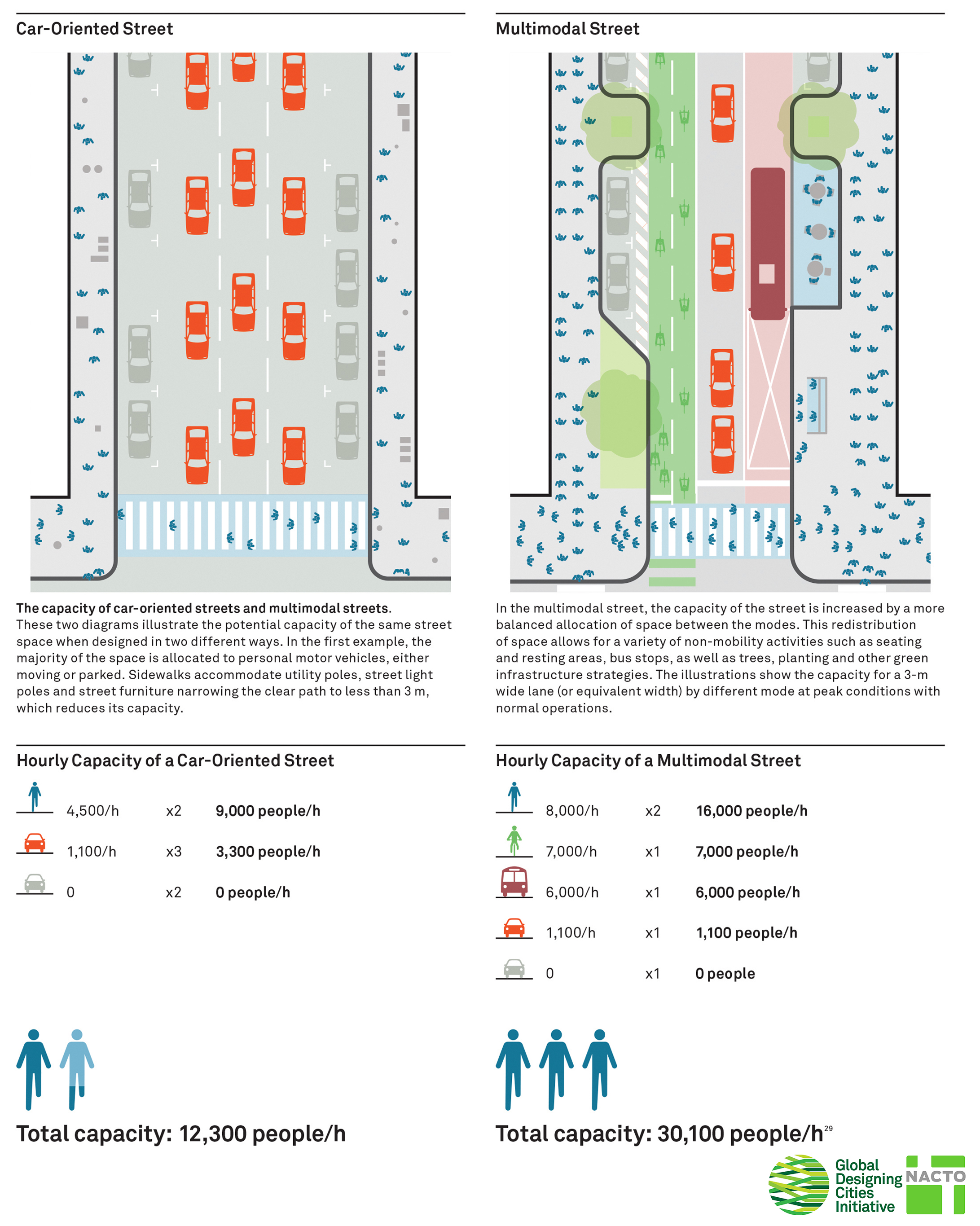
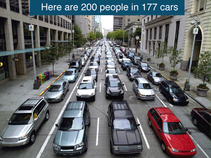
“Our whole country has largely been designed around cars, and that continues to be the case even with our digital maps,” Hamilton said. “There are plenty of people who don’t drive, and this big segment of the population is being excluded. It’s astounding how much is overlooked.”

Caspi said this technology could help pedestrians with or without mobility limitations. For example, people with strollers might want to avoid routes without curb ramps.

“Google Maps has trained us to minimize the amount of information we ask for about the environment,” Caspi said. “For us, it’s presumably low hassle to circumvent these things when we meet them on the ground. For someone with a mobility impairment, it’s a much bigger cost, but it doesn’t mean that there’s no cost to all of us.”

21 Feb 17:24

A UFO Abduction on the Streets of Dresden by OakOak

by Christopher Jobson

Here’s a fun piece in Dresden by street artist OakOak (previously) who also recently published a new book. You can follow more of his quirky pop-culture influenced street installations on Instagram. (via Street Art Utopia)

21 Feb 16:54

Apple Says Nebraska Will Become A 'Mecca For Hackers' If Right To Repair Bill Passes

by Tim Cushing

It looks like Apple decided to drop in on flyover country in hopes of thwarting a "Right to Repair" bill pending in the Nebraska legislature. It did not go well.

[T]he prospect of a Cupertino-based megacorporation losing business to local repair shops isn't a very sympathetic argument at the Nebraska statehouse. And so Apple has tried a slew of other tactics, according to state Sen. Lydia Brasch, who was recently visited by Steve Kester, an Apple state government affairs specialist.

"Apple said we would be the only state that would pass this, and that we would become the mecca for bad actors," Brasch, who is sponsoring the bill, told me in a phone call. "They said that doing this would make it very easy for hackers to relocate to Nebraska."

Apple probably expected its heavy-handed (and stupid -- more on that in a bit) "suggestion" to be taken more seriously by podunk legislators in the middle of nowhere. Unfortunately for Apple, Brasch isn't just a legislator in a state mainly known for corn and football-as-religion.

Brasch is not only an Apple customer, but she's a farmer who has had to deal with plenty of repair-blocking BS from companies like John Deere. She also has a background in computer science and an apparent tendency to not let corporate lawyers talk down to her.

Not only did Apple pick the wrong legislator to threaten, its threat is incoherent. I've spent most of the last 15 years in the Midwest and, trust me, it would take far more than a right-to-repair bill's passage to make Nebraska a mecca of anything. (Beyond college football, he said to head off the Cornhusker faithful most likely already demanding a retraction…)

Then there's the thing about "hackers." There's more than one type of hacker, but Apple dropped it as a pejorative term in hopes of conjuring images of hoodied figures sitting in dark rooms with the local SWAT team on speed dial and deploying some sort of encryption… you know, the evil kind.

All sorts of nonsensical arguments are already being raised in response to a handful of right-to-repair bills around the nation. The corporate version of "you'll shoot your eye out" has been deployed to portray DIY repair jobs as hospitalizations waiting to happen.

The idea that it's "unsafe" to repair your own devices is one that manufacturers have been promoting for years. Last year, industry lobbyists told lawmakers in Minnesota that broken glass could cut the fingers of consumers who try to repair their screens, according to Gay Gordon-Byrne, executive director of Repair.org. Byrne said she will also testify at the Nebraska hearing and "plans to bring band aids."

Apple's take is this: the "hacker mecca" thing plus a very short parade of not-all-that-horribles.

Brasch said the representatives made two other main arguments: They said repair could cause lithium batteries to catch fire, and said that there are already enough authorized places to get iPhones repaired, such as the Apple store.

Define "enough." As Brasch points out, getting her devices repaired "conveniently" involves setting up an appointment at the nearest Apple store, which is 80 miles from where she lives. Apple certainly doesn't mind taking money from rurally-located customers when selling devices. But it's not nearly as willing to make repairing their purchased products actually convenient.

And it's not just Apple. Other phone manufacturers have spoken to Brasch in an attempt to get her to drop the legislation, or at least rewrite it in their favor.

"They said just take out the 'phone' part of the bill and we'll go away," Brasch said. "That's tempting, but we need to repair consumer technology too."

Brasch's bill sprung out of her frustration with repairing her farm's equipment, which has been made increasingly difficult by John Deere's refusal to allow anyone other than repair shops it makes to profit from touching its products. Phone manufacturers have the same attitude. They express faux concern about consumer safety while preventing consumers from having any control over how their purchased devices are repaired. The concern most of these companies have for their consumers only extends as far as their ability to purchase add-ons, new products, and inconvenient repairs at non-competitive prices. The battle is over bottom lines, not consumer safety, no matter how it's spun and no matter how many hacker-based horror stories are spun.


Permalink | Comments | Email This Story
20 Feb 20:56

Decision Paralysis

Good point--making no decision is itself a decision. So that's a THIRD option I have to research!
20 Feb 20:51

Ex-Uber engineer describes her year of being sexually harassed at Uber

by Mark Frauenfelder

Susan J. Fowler joined Uber as a site reliability engineer in November 2015. She was sexually harassed at work and Uber's human resources punished her for reporting it. She says other women at Uber have had similar experiences and that many have quit in disgust.

After the first couple of weeks of training, I chose to join the team that worked on my area of expertise, and this is where things started getting weird. On my first official day rotating on the team, my new manager sent me a string of messages over company chat. He was in an open relationship, he said, and his girlfriend was having an easy time finding new partners but he wasn't. He was trying to stay out of trouble at work, he said, but he couldn't help getting in trouble, because he was looking for women to have sex with. It was clear that he was trying to get me to have sex with him, and it was so clearly out of line that I immediately took screenshots of these chat messages and reported him to HR.

Uber was a pretty good-sized company at that time, and I had pretty standard expectations of how they would handle situations like this. I expected that I would report him to HR, they would handle the situation appropriately, and then life would go on - unfortunately, things played out quite a bit differently. When I reported the situation, I was told by both HR and upper management that even though this was clearly sexual harassment and he was propositioning me, it was this man's first offense, and that they wouldn't feel comfortable giving him anything other than a warning and a stern talking-to. Upper management told me that he "was a high performer" (i.e. had stellar performance reviews from his superiors) and they wouldn't feel comfortable punishing him for what was probably just an innocent mistake on his part.

I was then told that I had to make a choice: (i) I could either go and find another team and then never have to interact with this man again, or (ii) I could stay on the team, but I would have to understand that he would most likely give me a poor performance review when review time came around, and there was nothing they could do about that.

Image: Pexels

14 Feb 19:49

State senator proposes ban on public funding of Bigfoot hunting

by David Pescovitz

Gallup, New Mexico state senator George Munoz is not pleased that a group led by Christopher Dyer, CEO of University New Mexico's Gallup campus, went on a Bigfoot research expedition and racked up $7,000 of expenses that were ultimately paid by taxpayers. The expedition was part of a Bigfoot conference Dyer organized on campus last year that he says "was the largest and most well-attended event in the history of this campus,”.

From KRQE:

In response to what happened, Sen. George Munoz is sponsoring a bill that would ban public funds from being spent on “looking for or catching a fictitious creature.”

“It’s sad that we have to do this, that they don’t have the ethics, that UNM doesn’t have the ethics to stop this,” Sen. Munoz said. “And now we have to draft bills to stop something that is not morally right,” Sen. Munoz said.

The senator had a little fun with the bill. It also bans publicly funded searches for Pokemon, leprechauns and the Bogeyman.