“The Trust for Public Land announced today that Washington, DC, ranked 1st on the annual ParkScore® index, improving from last year’s second-place finish. Washington climbed ahead of defending champion Minneapolis, which finished third. Saint Paul placed second and Arlington, VA, finished fourth.
Washington performed strongly on all ParkScore rating factors and claimed the top spot based on strong scores for park equity, which was added to the rating system for the first time this year. In the District, 98 percent of residents live within a 10-minute walk of a park, far exceeding the national ParkScore index average of 75 percent. Residents of Washington neighborhoods where most people identify as Black, Hispanic and Latinx, Indigenous and Native American, or Asian American and Pacific Islander have about equal access to park space as residents of neighborhoods that are predominantly white.
Across all ParkScore cities in the United States, residents in neighborhoods where most people identify as people of color have access to 44 percent less park space than residents in neighborhoods that are predominantly white. Residents in low-income neighborhoods have access to 42 percent less park space than residents in high-income neighborhoods.
The District’s ParkScore ranking was also boosted because the city reserves 24.1 percent of city area for parks, far exceeding the national average of 5.4 percent. The city earned strong marks for park investment and park amenities.
“We already loved our parks, but over this past year, as Washingtonians have made it a priority to spend more time outside, we have developed an even greater appreciation for our ability to play and gather in beautiful outdoor spaces across DC,” said Washington, DC Mayor Muriel Bowser. ”We’re happy to be back in the number one spot, and we’ll continue to make convenient access to world-class parks and playgrounds a priority for residents in all eight wards of DC.”
Nearby Arlington slightly outperformed Washington for park access. Ninety-nine percent of Arlington residents live within a 10-minute walk of a park, compared to Washington’s 98 percent finish. Arlington also scored extremely well for park acreage, park spending, and park amenities. However, the city’s ParkScore ranking was negatively affected by the new measures of park equity.
Residents of Arlington neighborhoods where most people identify as Black, Hispanic and Latinx, Indigenous and Native American, or Asian American and Pacific Islander have access to 34 percent less park space per capita than residents in neighborhoods that are predominantly white. Residents of low-income neighborhoods also have access to 34 percent less park space.
MEASURES OF PARK EQUITY ADDED IN 2021
For the first time in the study’s 10-year history, the 2021 ParkScore® index includes measures of park equity. The new equity measures were inspired by the national awakening on racial justice and The Trust for Public Land’s longstanding commitment to equitable park access and quality. The data revealed significant disparities in park space across racial and economic lines.
“In a majority of ParkScore cities, white neighborhoods and high-income neighborhoods have a disproportionately higher share of park space,” says Linda Hwang, The Trust for Public Land’s Director of Innovation and Strategy. “That’s not right and it’s not fair. The Trust for Public Land believes there should be a quality park within a 10-minute walk of home of every person in America, and we are committed to centering equity as we advocate for parks and open space in cities throughout the United States.”
To complement the annual ratings list, The Trust for Public Land today released a groundbreaking report describing how parks are working to improve equity and address other problems facing cities. The report, Parks and an Equitable Recovery, found that across the 100 largest cities, there is a significant disparity in who has access to available park space, and the disparity falls across racial and economic lines. The report also details how parks are critical components of our recovery from the pandemic, economic recession, climate crisis, and longstanding racial injustice.
PARKSCORE RANKINGS FOR 2021
According to the Trust for Public Land’s 10th annual ParkScore® index, Washington, DC, has the best city park system in the country.
The ParkScore® index ranks park systems in the 100 largest U.S. cities and is widely considered the gold standard for park evaluation. The 2021 edition reported that 75 percent of residents across all ParkScore cities live within a 10-minute walk of a park, the highest access score in the index’s 10-year history.
The addition of park equity as a rating factor affected the rankings of many cities. Baltimore rose 28 places on the ParkScore index, from 58th in 2020 to 30th this year. Toledo, OH, rose 27 places, from 77th in 2020 to 50th this year. Newark, NJ, also jumped 27 spots to 42nd.
Twelfth-ranked Boston and sixth-place San Francisco remain the only ParkScore cities where 100 percent of residents live within a 10-minute walk of a park or other public open space.
Boise defended its title as the best park system for dogs, with a nation-leading 6.3 dog parks per 100,000 residents, narrowly beating Portland, Ore. Irvine, Calif, received top marks for basketball hoops and Madison, Wis, scored best for playgrounds. Boston earned top marks for splash pads and other water features, beating out 2020-leader Cleveland.
The number of playgrounds per capita in ParkScore cities increased by four percent since last year, largely because of “shared used” agreements that opened school playgrounds for neighborhood use after school hours and on weekends. The number of playgrounds in ParkScore cities has increased by 29 percent since 2012, when the ParkScore index began tracking this indicator.
The number of dog parks increased by more than two percent, continuing the trend first reported by The Trust for Public Land five years ago.
PARKSCORE METHODOLOGY AND RANKINGS
For the last 10 years, ParkScore rankings were based on four factors, and this year, a park equity measure was added. This new rating factor was added to help city leaders understand and prioritize equity when making decisions about parks.
· Park equity compares per capita park space in neighborhoods of color vs. white neighborhoods and in low-income neighborhoods vs. high income neighborhoods and 10-minute-walk park access for people of color and lower-income residents. Park systems score higher if disparities are low or non-existent;
· Park access measures the percentage of residents living within a 10-minute walk of a park;
· Park acreage is based on a city’s median park size and the percentage of city area dedicated to parks;
· Park investment measures park spending per resident; and
· Park amenities assesses the availability of six popular park features: basketball hoops, off-leash dog parks, playgrounds, “splash pads” and other water play structures, recreation and senior centers, and restrooms.”
Music, like history, is iterative. Nobody knows that better than hip-hop artists, for whom sampling other songs is a core component of making new tracks.
Now everyone has a chance to experience what it feels like to sample and mix beats, thanks to the Library of Congress’s new hip hop music project, Citizen DJ. The open-source web application allows people to create new music using the library’s vast audio collections, which date back more than a hundred years.
“My dream is that there’s a whole new generation of sounds that can be made using this shared material,” says Brian Foo, the library’s “innovator-in-residence” and Citizen DJ’s creator. He hopes everyone from amateur musicians to Kanye West uses the new tool.
Foo fell in love with hip-hop culture as a teen in the 1990s. He became enthralled by the idea of the DJ as a collector of sounds (he also took up break dancing). He held onto those interests even as he transitioned into a career in computer science and data visualization.
Citizen DJ includes six vast collections of audio files, ranging from motion picture soundtracks from the early 20th century to an archive of dialect samples from oral histories, public speeches and linguistic interviews. (Heads up, Washingtonians: About a dozen files in that collection are recordings of D.C. children from 1968.)
Each colored square is a different sound.
The thousands of hours of recordings have no copyright restrictions — they’re all free to sample, download and share.
Users can search the recordings by subject, pitch or musical note and then feed their selections into a mixing program, where they can mess around with different drum machines and beat patterns.
The process of browsing through the collections is perfectly suited for the quarantine era, even without the goal of making music. It feels like being lost in a colorful maze of sound.
When he’s not working in the Library of Congress’s LC Labs on Citizen DJ, Foo works as a data visualization artist at the American Museum of Natural History in New York, where he lives. Until the pandemic hit, his one-year gig with the Library of Congress brought him to D.C. about once a month.
Foo hopes the project provides people quarantined at home with a fun way to listen to music and explore new genres and historical eras.
“I’m hoping the public can find more weird stuff and share it,” he says. “There’s a lot that I dream about for this project.”
Today’s launch is a partial rollout ahead of the full launch slated for this summer. Foo and other library staff will host a live demo and answer questions at 3 p.m. on Facebook Live, and they’re accepting feedback on the beta version for the next few months.
Last week, Rich Reyes-Gavilan discovered a note appended to the Little Free Library next door to his home in Mt. Pleasant.
“Little Free Libraries, however adorable and well meaning, do more harm than good for the communities in which they appear,” the anonymous missive begins. “Rather than promote literacy or building communities, Little Free Libraries (LFLs) introduce a host of problems including stealing patronage from existing public library branches, the corporatization of literary circulation, and helping to gentrify urban neighborhoods.”
“I just thought it was maybe somebody who knew me and was trying to help me. Or maybe hurt me. I just couldn’t tell,” Reyes-Gavilan says. He didn’t agree with contents of the note, and spur of the moment, he decided to snap a photo and post his thoughts to Twitter.
“OK, I just want to assure my neighbors that I am not responsible for this screed,” the tweet read. “We at @dcpl are not against little free libraries and don’t see them as competition. Some years ago I found a Calvin & Hobbes book in one that I looked at momentarily.”
Several people that DCist spoke to agreed with Reyes-Gavilan that the small book exchanges are no replacement for public libraries.
“We go to the public library all the time for the story time and the socialization,” says Canden Arciniega, a Silver Spring resident who has lived in the D.C. area for about a decade. Arciniega has two young children who love both Little Free Libraries and public libraries. “I think of libraries as less a place where you can get books and more as a place where you can get an insane number of services for free,” she says.
Diamond Newman, a Capitol Hill resident who uses and loves Little Free Libraries, says that they create an opportunity to connect with people in a city where she feels people are often “gathered, but not connected,” she tells DCist.
OK, I want to assure my neighbors that I am not responsible for this screed. We at @dcpl are not against little free libraries and don’t see them as competition. Some years ago I found a Calvin & Hobbes book in one that I looked at momentarily. pic.twitter.com/6UrXjJA03C
Reyes-Gavilan says he meant his tweet to be lighthearted (the shade you’re clocking in the last line was intentional, he says), but also informative. “I think as chief librarian for Washington, D.C. it’s incumbent on me to comment whenever I can on things that may be of broader interest,” he says. “I didn’t think it was going to touch such a nerve, frankly.”
But touch a nerve it did.
“What a ridiculous sentiment and how cowardly not to sign the letter,” one person responded to the tweet. “People in this city have lost their goddamn minds,” reads another. “Somebody needs a better hobby. May I suggest … reading,” a third commenter wrote.
While the majority of replies expressed confusion or anger at the note’s message, a few appeared to be in agreement.
“I used to run a book distro that superficially resembled a LFL. When people would leave their (99% garbage) books, we discarded them. Why? Because LFL’s are everything this poster says they are. And I’m glad someone said it,” said one.
As the tweet gained some traction and attention (far more than his usual tweets, Reyes-Gavilan says) local blog Popville posted his tweet. It generated more than 100 comments, nearly all of them in angry opposition to the note’s contents. DCist was unable to find or contact the author of the note, who may have also stuck several more notes to Little Free Libraries all over Mt. Pleasant with an adhesive that’s proving difficult to remove.
The mini controversy was surprising to Reyes-Gavilan and many others, but it’s not the first time such an argument has been made about Little Free Libraries. In 2017, two librarians in Toronto, Jane Schmidt and Jordan Hale, published a paper in the Journal of Radical Librarianship arguing that Little Free Libraries are “a highly visible form of self-gratification cleverly disguised as book aid.”
The small book exchanges, which are generally registered with the official Little Free Library nonprofit that started in Wisconsin in 2009, mostly show up in wealthier, white neighborhoods, Schmidt and Hale found. Little Free Libraries are “examples of performative community enhancement, driven more so by the desire to showcase one’s passion for books and education than a genuine desire to help the community in a meaningful way,” they write.
“There was something that kind of irked me about the title,” Schmidt told Citylab that year. “As a librarian, my gut reaction to that was, ‘You know what else is a free library? A regular library.'”
Reyes-Gavilan says he finds such arguments misguided. Thinking that LFLs are taking business away from public libraries is “like saying yard sales are detrimental to Amazon.com,” he says.
In response to arguments that the boxes fail to eliminate book deserts or improve literacy, he says “That’s all true. But they’re not designed to do that. And I guess I would be angry if their purpose was to do that, but their purpose is to create little harmless book exchanges that create serendipitous moments for people.”
But are they harbingers of gentrification?
“In neighborhoods with more disposable income, there might be more people with money to spend on getting one,” Reyes-Gavilan says. “I can see people viewing Little Free Libraries the way they view dog parks or bike lanes, but that’s almost not for me to comment on.”
Arciniega tells DCist she buys the argument that Little Free Libraries are, at the very least, a signal of gentrification. A couple of months ago, she tried to set one up herself to help rotate some children’s books out of her home, and she was overwhelmed by the amount of work people with LFLs appear to put into the endeavor. They had themed weeks for their boxes, decorating them and buying books for the occasion. They celebrated holidays with new books for their boxes, and people scouted for cheap books to buy to keep their little libraries stocked. Not to mention, buying an LFL from the official source (as opposed to building one yourself) can run you hundreds of dollars. Even if none of that was technically required, Arciniega says she couldn’t help but feel pressure to devote time she simply did not have.
“You have to have time and money for this,” she says. “I am middle class and even I don’t have the time or money for this … I can’t see a lot of working families who don’t have much disposable income having the ability to do it.”
Newman says she’s never heard of them being related to gentrification, but upon thinking about it, she only sees them “in certain neighborhoods.”
Taylor Mulcahey, a Bloomingdale resident who also loves Little Free Libraries, says that while she does believe that LFLs are more available to some residents than others, the note appended to that Mt. Pleasant book box is using them as a “scapegoat.”
“When we are pushing people out of neighborhoods, that’s a problem and a very valid issue, and we should have language and ways to talk about that, and it should be showing up in internet conversations,” Mulcahey says. “But you stir controversy up over something like this and then people put their energy into that instead of talking about like actual problems. And people love controversy so of course a bunch of people engaged with that tweet … But I just don’t think it’s productive.”
There’s No Paywall Here
DCist is supported by a community of members … readers just like you. So if you love the local news and stories you find here, don’t let it disappear!
The Nats won the World Series! WAAHOOOOOOO! And now, ever on-watch for the urbanist angle to a story, GGWash is here to shamelessly embed all of the mocking tweets the DC Council’s Twitter account posted about Houston’s zoning during the World Series.
Houston, for those not in on the joke, is the largest American city without traditional zoning. It’s generally legal there to build a skyscraper much closer to low-density houses than in other US cities. And while it’s true that zoning has seriousdownsides, and that Houston has other regulations that often work in similar ways, it’s also true that this is great policy wonk joke fodder.
So here you go, beginning with this first tweet from the night the Astros beat the Yankees in the final game of the ALCS:
Whoever runs the council twitter account liked that one so much they posted it twice.
And then, for a few unfortunate days, they put a moratorium on the zoning jokes. And the Nats lost three straight games. Finally as the World Series was set to return to Houston, @CouncilOfDC owned up to it having caused the Nationals’ setback, and brought back the puns.
Well, sorry, but it looks like it’s back to the zoning jokes. We did zoning jokes before Games 1 & 2 & we won. No zoning jokes since, no wins since. We’re trying to remain semi-detached, but it’s time to re-zone our @Nationals coverage. Houston can’t be in the zone without zoning pic.twitter.com/MsPHh0q9OS
Houston has no zoning. DC does. So, in principle, the @nationals should be able to control the strike zone. And make the outfield a no-fly zone.
Why did I go all in on zoning jokes? I am so in the weeds with zoning jokes! pic.twitter.com/mnjjSbV9MS
After exacting a win in Game 6, they were all-in for Game 7.
May the best team win:
- DC. Zoning. Our city’s historic map IS a baseball diamond! (@treavturner very legally ran the SE border of the map last night)
- Houston. No zoning. See the no-zoning mullet below? (Business in the front & party in the back)
Go @Nationals! #FINISHTHEFIGHTpic.twitter.com/M0O3bgWz5h
FYI: phantom lakes of methane exist on the earth of the outer solar system.
Picture a world where rain falls, gathers in lakes and ponds, seeps into the surrounding rock, and evaporates away, only to fall again. There's just one catch: the rain isn't water — it's liquid methane.
So I was enjoying a late brunch on the patio of Napoli Pasta Bar Sunday afternoon (great brunch, by the way), lazily watching the Sherman Avenue traffic roll past in the wilting heat, when a black truck turning left on Girard Street catches my eye — and I’ll be damned if there isn’t a long, white ferret dangling out the passenger-side window. The passenger, it seemed, was stone asleep, and the driver apparently unaware of the critter trying to make its escape. The truck makes its turn, disappears up the street, and the next thing I see is a white furry face peeking out from behind the wheel of a parked car — the little guy made his escape.
Sherman and Girard St, NW
I notified animal control, and spent the remainder of the meal with one eye on my eggs and one on the albino ferret skulking around under a blue sedan across the street. Our meal complete, and the animal control officer nowhere to be found, we couldn’t leave the poor little guy to the ravages of urban traffic, so we and a few other curious, concerned passers-by spent a good half hour chasing Garrett (as we came to call him) away from moving vehicles, trying to entice him with water, bread, and other refreshments, and wondering what to do. Mostly he seemed pretty overwhelmed by the day’s adventures, and content to nap in the shade beneath his favorite blue sedan.
Fortunately, the owner of said sedan appeared, and happened to have farmboy credentials and experience capturing wildlife. I, fortunately, was in possession of a cardboard box (yesterday was moving day; a real community effort). So when it became clear that animal control was still a good 30 minutes away, we put Garrett the Ferret in a box, and drove him up to the Humane Rescue Alliance. His arrival was warmly celebrated by a team of animal-lovers, who noted that he was “alert, hydrated, and curious,” which I guess is the trifecta of ferret health.
So all of this is just to say: if your ferret might have leapt from the passenger window of your truck on Sunday afternoon in Columbia Heights, we would like to applaud you for raising such an alert, curious, and charming ferret, admonish you to keep your windows rolled up, and inform you that you can collect him from the Humane Rescue Alliance of Washington DC. If he is not claimed in the next day or so, he will be put up for adoption, and let me tell you, Garrett was such a charmer I’m having second thoughts myself!
A suit is a more or less complicated garment designed to be worn with a tie, and the tie is designed to go with the shirt. And so begins a game of self-expression played with multiple pieces. A whole set of emotional and social and aesthetic messages can be sent, with brashness or subtlety. Move to a smaller set of pieces and you have gone from chess to checkers.
Casual Friday has engineered a hostile takeover, but the suits will win again
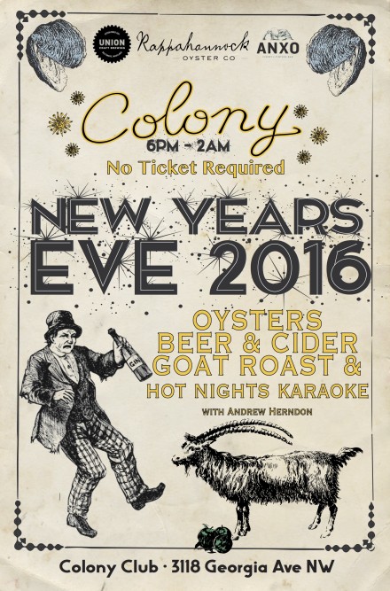
“We’re having a New Year’s Eve party here at Colony Club. It’s going to be a lot of fun! We’re getting 1,000 oysters, roasting a whole goat on a spit, karaoke upstairs, live music downstairs. Beer and cider specials all night. We’ve just added DJ AyesCold to the line up too. No tickets required- trying to make it as accessible as possible.”
By my calculations if we nuked the polar ice caps on Mars we would make an ocean of 36 feet deep across the whole planet. — Jose Canseco (@JoseCanseco) December 11, 2015
And then it appears that redirecting Saturn’s moon Triton to collide into Mars could make the planet habitable faster
Yes i DID think about the missing magnetic field. It is created when the Triton collision liquidates Mars outer core into molten iron. — Jose Canseco (@JoseCanseco) December 11, 2015
House appropriators hope to release the text of an omnibus spending bill on Monday. Work on the bill has been delayed by debates on policy riders, even as a continuing resolution (CR) funding the federal government was set to expire Friday. The Senate passed a bill Thursday extending the CR through Dec. 16, and the House is expected to approve it Friday. Rep. Hal Rogers (R-Ky.), chairman of the House Appropriations Committee, said he hopes to have the omnibus bill completed and released Monday, but acknowledged that schedule may make it difficult to pass the bill before the new CR expires. [Roll Call]
A Soyuz spacecraft carrying three International Space Station crew members landed in Kazakhstan early Friday. The Soyuz landed in Kazakhstan at 8:12 a.m. Eastern time, nearly four hours after undocking from the ISS. The Soyuz returned to Earth NASA astronaut Kjell Lindgren, Roscosmos cosmonaut Oleg Kononenko, and JAXA astronaut Kimiya Yui after a 141-day mission. Three new ISS crew members are scheduled to launch on another Soyuz Dec. 15. [Spaceflight Now]
The ground system for the next generation of GPS satellites is facing a two-year delay. The U.S. Air Force said the GPS Operational Control Segment (OCX) won’t be operational until 2021, two years later than previously planned. Without OCX, upcoming GPS 3 satellites will provide services no better than current GPS 2F satellites. Raytheon won the OCX contract in 2010 and has struggled with the work, leading to two reviews by the Pentagon’s top acquisition official in the last year. “The OCX program is a disaster, just a disaster,” Air Force Gen. John Hyten, commander of Air Force Space Command, said earlier this week. [SpaceNews]
SES said its SES-9 satellite will launch on a Falcon 9 next month. The satellite operator announced Thursday that the satellite has arrived at Cape Canavaral for a mid-January launch on a “full thrust” version of the Falcon 9. SpaceX and Orbcomm said earlier Thursday that a Falcon 9 will launch 11 Orbcomm satellites Dec. 19, pending the outcome of a static fire test on the launch pad Dec. 16, on the first Falcon 9 mission since a June launch failure. The SES-9 mission will be the second or third Falcon 9 launch, depending on the scheduling of a Dragon cargo mission to the space station. [SES]
Component problems forced NOAA to delay the launch of a weather satellite by six months. A transistor in the GOES-R satellite failed during a two-month environmental test at its prime contractor, Lockheed Martin. That failure, and a problem with a solar array control mechanism, led NOAA to conclude that rushing the repair work to meet a March 2016 launch date was unwise. The spacecraft is now scheduled to launch in October 2016 on an Atlas 5. [SpaceNews]
House appropriators hope to release the text of an omnibus spending bill on Monday. Work on the bill has been delayed by debates on policy riders, even as a continuing resolution (CR) funding the federal government was set to expire Friday. The Senate passed a bill Thursday extending the CR through Dec. 16, and the House is expected to approve it Friday. Rep. Hal Rogers (R-Ky.), chairman of the House Appropriations Committee, said he hopes to have the omnibus bill completed and released Monday, but acknowledged that schedule may make it difficult to pass the bill before the new CR expires. [Roll Call]
Members of Congress and their staff are defending a new commercial space law with controversial provisions about space resource rights. In a speech Wednesday, Rep. Brian Babin (R-Texas), chairman of the House Science space subcommittee, argued there were “a number of misconceptions about the intent and the legality” of the space resources section, which requires companies to extract resources in order to claim rights to them. House and Senate staff members said they did not believe the law granted any new rights to companies but instead made clear existing policy. [SpaceNews]
What may be the last Zenit rocket will launch Friday. The Zenit is scheduled to lift off at 8:45 a.m. Eastern from the Baikonur Cosmodrome, carrying the Elektro-L2 weather satellite. Strained relations between Russia and Ukraine, who makes the Zenit, and a lack of commercial business for Sea Launch, mean that no additional Zenit launches are currently planned. [Spaceflight Now]
Have astronomers discovered new planets in the distant fringes of the solar system? Probably not. Papers submitted earlier this week by astronomers in Mexico and Sweden claim to have detected large objects in the outer solar system in data from the ALMA radio observatory in Chile. Many other astronomers, though, are skeptical of the claims, believing the objects may be data artifacts and not real objects. [Scientific American]
Photographer Porter Tinsley created this animated GIF from 30-plus still images she took with her Nikon camera Nov. 7.
With images like these, it’s no wonder California — not to mention the Twittersphere — freaked out Saturday evening when an unannounced test of a submarine-launched Trident missile lit up the evening sky.
Photographer Porter Tinsley and her wife were on the shore of California’s desolate Salton Sea taking long exposures and time lapses with three different cameras when they witnessed what they thought at the time was a chemical or nuclear weapon detonating over Los Angeles two and a half hours to the west.
Fat chance. The pyrotechnics Tinsley and thousands of other casual skywatchers observed Saturday were due to the first of two Trident 2 D5 missiles with dummy warheads the U.S. Navy test fired between Saturday evening and Monday afternoon. The big, bright flash some mistook Saturday for a detonation, missile intercept or UFO is actually the result of the solid-fueled Trident missile jettisoning one of its three stages.
In a statement issued Monday night, U.S. Navy Adm. Ceil Haney, head of Strategic Command, described Saturday’s test flight — one of 156 such tests since 1989 of the Lockheed Martin-built strategic “demonstrate[s] the readiness of our nation’s nuclear triad and serve to assure our allies and deter our potential adversaries.”
The test occurred the same day U.S. Secretary of Defense Ash Carter, speaking at the Reagan National Defense Forum in Simi Valley, California, called out Russia for engaging in “challenging activities” at sea, in the air, in space and cyberspace.
Monday’s test, conducted in the afternoon, caused far less brouhaha than Saturday’s test, which was widely documented on Twitter and social media by unsuspecting skywatchers as far south a Mexico.
Strategic Command does not announce Trident tests ahead of time in order not to tip off U.S. adversaries who might want to watch and learn.
Among the select few not caught off guard by the test were five U.S. lawmakers, including Sen. Joe Donnelly (D-Ind.), who were onboard the submarine, the USS Kentucky, to watch Saturday’s launch with Haney and others.
U.S. lawmakers, including Sen. Joe Donnelly ( in gray jacket and blue button down), onboard the USS Kentucky submarine to observe a Nov. 7 test launch of a Trident 2 5A missile. Credit: U.S. Navy/ Byron C. Linder
NASA has added a bunch of not-exactly-recent photos to its Flickr stream, including these dramatic photos of last October Antares launch failure. The Orbital ATK rocket exploded moments after lifting off on what would have been the Cygnus space tug’s third paid cargo run to the International Space Station.
Cygnus is slated to launch Dec. 3 atop an Atlas 5 rocket Orbital ATK bought from United Launch Alliance. Antares, meanwhile, is slated to return to flight next spring using a different engine, the Russian-built RD-181.
WASHINGTON — The Office of the U.S. Trade Representative (USTR) is starting a review of a decade-old policy that discourages the use of Indian launch vehicles by American companies, an official said Oct. 20.
Samuel duPont, a director in the USTR’s international trade and development office, told a working group of the Federal Aviation Administration’s Commercial Space Transportation Advisory Committee (COMSTAC) that demand by American companies for commercial launch services had led the office to start a review a policy that has been in place since 2005.
That policy, implemented through export control licensing, “discourages U.S. commercial satellite operators from purchasing launch services from Indian launch companies,” duPont said at a meeting of COMSTAC’s International Space Policy Working Group here Oct. 20. That policy specifically affects the Indian Space Research Organisation (ISRO), India’s space agency, which builds and operates launch vehicles.
The current policy dates back to 2005, when the U.S. was trying to encourage India to sign a commercial space launch agreement. Such an agreement, similar to ones the U.S. signed in the early 1990s with China, Russia and Ukraine, was intended to “ensure ISRO adhered to market-oriented practices in the commercial launch sector,” he said. Those earlier agreements, which expired by the late 1990s, included quotas on the number of commercial launches those countries could perform and guidelines on prices they could charge.
However, negotiations on such an agreement with India broke down in 2010. “It became clear that there was no path forward that was going to satisfy both our position and India’s position,” duPont said. “We haven’t had any further engagement with India on an agreement since 2010.”
With a launch agreement effectively abandoned, duPont said growing demand for commercial launches led USTR to reconsider its current policy. “We have been approached by U.S. satellite operators and manufacturers who have complained to us about a shortage of launch services,” he said. He did not disclose what companies were interested in Indian commercial launches.
USTR is just starting the review, and duPont said there was no formal schedule for completing it and making any change in current policy. Of particular interest to the office is any pricing information on Indian launches. “We’re interested in any information on how ISRO has been pricing its services and whether they have, in a broader sense, [been] behaving as a private company would in the industry,” he said, adding that the USTR had no evidence of unfair pricing of Indian launches.
A PSLV rocket launched ISRO’s Mars Orbiter Mission in November 2013. Credit: ISRO
India has been seeking a greater share of the commercial launch market in recent years, primarily through its Polar Satellite Launch Vehicle (PSLV). India’s government approved a budget earlier this year that funds the construction of 15 PSLV rockets between 2017 and 2020 to meet what ISRO anticipates to be growing commercial demand for the vehicle.
That interest has included some U.S. companies. A PSLV launch in September included, as secondary payloads, four small satellites built by San Francisco-based Spire. Spaceflight Services, a Seattle company that brokers secondary payload opportunities, arranged for that launch. Company officials did not respond to a request for comment regarding what effect, if any, current U.S. policy had on arranging that mission.
Some COMSTAC members raised questions at the meeting about any potential change in policy. Of particular concern was the possibility that U.S. launch providers might have to compete with a foreign space agency.
“We have, as national policy, that we don’t allow our own space organization to compete with our private launch providers,” said Jeff Greason, chief technology officer of XCOR Aerospace. “I don’t understand why we have correctly determined that’s bad public policy, but it’s perfectly fine for other national space agencies to compete with our private launch providers.”
DuPont said the policy was not based on whether or not Indian launch services were provided by government agencies, but instead how those services were marketed. “ISRO could be behaving as a free market enterprise would,” he said. “That’s what we’re trying to discover through this process.”
What’s better than blowing up a nearly 500-foot smokestack? How about toppling two in such a way they collide like sumo wrestlers, exploding into righteous falling showers of dust?
That was the wonderful scene on Saturday, when Scottish work crews demolished the chimneys of the Cockenzie Power Station east of Edinburgh. The coal-fired plant had provided energy to the region since the late 1960s, but was decommissioned in 2013 over pollution concerns. In 2009, authorities called it the worst facility in Europe for nitrogen-oxide emissions, which can cause smog and respiratory problems.
Locals got to breathe in a little bit of Cockenzie one last time as its stacks disintegrated into powder, thanks to explosives packed into 300 holes around the bottom. Here are a couple different views of the mutual suicide:
@wskent... even if they don't choose YOU to be the LoC, worth following the search process-- if they do end up choosing the kind of person they say they want, there could be a bit of a shakeup at the institution, and probably some interesting work to be done in the office around that person.
Pallone wants to talk fantasy sports — FCC lays out net neutrality arguments
Few people have had as much of an impact on the world of urban wayfinding as Lance Wyman. Now in his seventies, the New York-based designer is still young enough to take on new projects while having more than enough success behind him to enjoy a career retrospective.
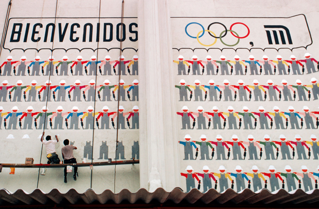
Currently on view at Mexico’s Museo de Arte Contemporáneo de Monterrey (MARCO) is Lance Wyman: Urban Icons. It first exhibited last year in Mexico City, where Wyman’s work for the 1968 Olympics (and a new subway system shortly after) established him as one of the world’s best at helping humans make their way around almost any kind of man-made environment.
His career stretches well beyond wayfinding, including logos and branding for institutions like MARCO. But it’s clear in speaking to Wyman that few things excite him as much as creating something that not only helps people find their way but adds to a city’s identity.
Wyman’s career keeps taking him south of the border. While his legacy is on display in Monterrey at the moment, he’s working, yet again, on a project in Mexico City. CityLab spoke with Wyman about some of the work he’s done all over North America and what he still hopes to accomplish.
How did you first get interested in urban wayfinding?
One of the first things was a taxi, bus and subway strike that happened in New York when I was working with the George Nelson office. I was living up on East 72nd street and the office was down on 22nd, East or West, I don’t remember. I walked to work the first day and realized I was seeing the city for the first time in a way I had never seen it before. The second day I took a different route and I realized between two points in the city it was a very different experience. I did the same thing for the duration of the strike, I think it lasted for a week, and that gave me a sense that cities are more than what meets the eye at a glance or on a map.
Chrysler Pavilion signage at the 1964 World’s Fair. (Lance Wyman)
George Nelson was an interesting person and an interesting office to be working with. The community group around our building at the time asked him for suggestions as to how they could unify that area of the city. He sent me out to photograph what was out there and I started taking photographs and, like Hockney would, placing a story by putting photographs together. It gave me a sense of the city being formed by quite a few things making it what it is.
I was into graphic design at that point and I had some wayfinding experience that was more exhibit based. I did a World’s Fair pavilion for George, and that had five islands. So just by its nature I had to do signs that told you where things were in the exhibit. So it was a combination of these things that really got me following my nose. It certainly gave me the interest of going in that design direction.
Landing the Mexico City Metro project must have been a dream commission for you then.
Actually, I started on the Mexico Olympics when I was 29 and it was through the Olympics that [the] Metro came, which I got when I was around 31. Creating iconography for an Olympics had already been established. Tokyo had done a good job of that in ‘64, so it was more or less establishing a way of identifying to an international audience that speaks different languages. The one thing that got me really going in the Olympics was the cultural program.
(Lance Wyman)
We decided to have one cultural program for each of the 19 sporting events. Basically, what I did was design a group of 19 symbols for a very diverse system of programming. And it wasn’t like the traditional Olympic programs—sporting events where people knew what everything was—they were very different. ...[But] they make it look like it was part of one program.
So when I got involved with the Metro and realized that this type of iconography could be applied to a system like that, I suggested it and we did it. That really was a dream program. Not only was I doing something that was going to communicate to people in different languages, I was doing something that the people in the cityliked. And it really brought outa lot of the history and a lot of the dynamic of the city. It was like being an archaeologist bringing it all to the surface, visually. It was really powerful. I’ve been trying to do that ever since.
The other thing that came out of that experience was that I realized ... I wasn’t just designing something for people who couldn’t read. It communicated better than language for the obvious reason of not having to be translated, but it also gave you a really quick visual reference to something, and the icons were designed well.
Did you design the Metro icons anticipating the kind of expansion it has had since?
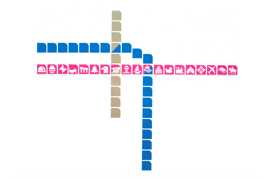
Yes and no. I did the first three lines. I did the first one in Mexico City and then I came back to New York and started my office here but I kept in touch with my two assistants and we designed Line 2 and 3. Now they have 12.
A diagram of Mexico City’s first three subway lines and the icons for Line 1. (Lance Wyman)
The one thing that we didn’t do is create a manual. But, in fact, a lot of the guidelines that would have gone into a manual I wasn’t savvy enough to really understand at the time. Obviously, you want to make all the icons different and you want to make them reference something meaningful in each one of the station areas. I didn’t think about it in terms of international communication where, if you’re visiting from China and you go to the station that has a duck for a symbol, you can tell your friend immediately, “Meet you at the duck station” in Chinese or any language you speak. That should have been a very basic principal.
What’s happened now is that some of the icons of the station depend more on depicting things that come out of Aztec cultures, things that even the Mexican population would have a hard time describing as far as what they are, so there’s a weak area. But it still works.
(Lance Wyman)
The last time I was in Mexico, I just wanted to experience one of the lines as a passenger, not a designer. I went to one end of the line, got on the train and went all the way to the other end. And where the system really works is when you’re inside a train. They have a line map, and this came from designing the first line for our system, over the car doors. When you come into the station the line map is sequential with the icons. And then in the station on the walls they have the icon for that station. It just worked so well. I didn’t do the icons on that particular line except for the stations where they cross the with other lines.
The experience made me curious about the line and that part of the city, and that was really experiential. I wasn’t looking for kudos or any reason why I should like it, I just liked it because that was the experience I had and it worked.
And you designed the map for the system as well, right?
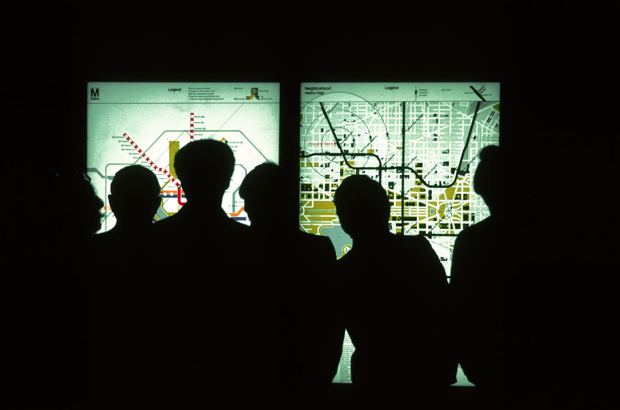
I did both maps [the system map and the neighborhood maps at each station]. With the neighborhood maps I worked very closely with the architectural team, and it was through those maps that Bill Cannan and I were asked to submit a proposal for the [Washington,] D.C., system. It was more the station maps that got us involved in that project than the system map.
One of the things we developed was the concentric circle system to tell someone how far they had to go to get into the environment around the station. We ended up using that in Washington, too. I don’t know if that was the first time it was ever used but I hadn’t seen it before we did Mexico. It’s so helpful to be able to give people an idea of how long or how far they have to go to get to places.
Wyman’s system and neighborhood maps as seen at a Washington, D.C., Metro station. (Lance Wyman)
For the system map for Mexico, I lined up the icons just one next to the other and I put the three lines together. Now, with 12 lines, it kind of looks like the space of an iPad. With the technology we have, it really does make sense to hang on to the idea of using icons. You can give context and then you can go to the icon, get to the station, and go to Google Maps if you want to see what’s happening at that station area.
We navigate our lives now with icons, illiterate or not. Now it’s a matter of designing the systems and designing better icons and better systems of using them, and that’s just a lot of fun for me because I was in it from the very beginning. When it works, it’s like writing poetry. You capture the essence of something that’s important, and it’s nice because there’s immediate feedback. I’m usually working with people who are not designers, and when I get feedback it’s usually from a different place or different from how a designer would give me feedback.
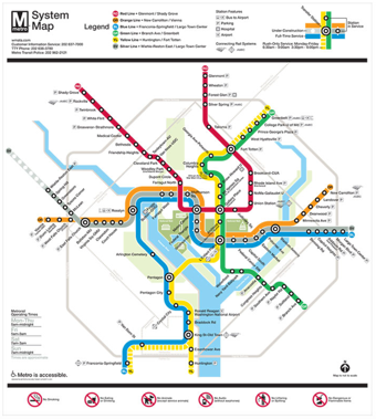
You developed an icon system for D.C.’s metro system as well, but it was never used. How did you develop that system and why isn’t it in use?
We researched over 85 projected stations, and we did that in a way where I was able to visualize a lot of them. Washington has so much history and so much to make visible. I wanted to, after the experience of seeing how effective they were in making the city visible in Mexico, do that again.
(Lance Wyman)
But we had to use an approach that Massimo Vignelli mandated when he did the signage system, and that was to use more of a diagrammatic map like the London Underground. In doing that map, we made the lines very thick so that we could eventually incorporate symbols in them. That was helpful as far as a dominating color code system. Once the system got started I don’t think anyone anticipated how complicated just keeping it running would be. The map was effective as it was, so we just never took that next step to implement the icons.
I’d still like to do that. I don’t think it’s 100 percent off the table. I hope not. In redoing the map that’s in Washington now, I have updated some approaches to the icons and presented them, but I think before that we have to shorten the names of some of the stations and that’s hard enough. It’s not just a graphic problem.
How complicated was it to add the Silver line to your D.C. map?
It was very complicated, because as soon you start putting more weighty colors in there, like the black, it deadens the whole center of the city, so putting those nubs [that identify where three lines now serve one station] that are there now was a big breakthrough.
I was really concerned, because it was a process of trying to keep the color lines as bold as I could and I had to diminish the weight of the lines to get that Silver line to pass through. It was a real process. It looks simple at the end, but there were moments there where I was really concerned that it wasn’t going to be capable of doing that.
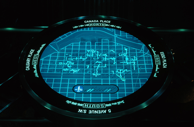
In the ‘80s you designed multiple walkway systems in Canada. What were some of the unique challenges you faced with those projects?
I remember going up to Calgary, that was the first one I did, +15. I remember taking a walk with the city planners through the system and I literally got a headache because you saw nothing to give you reference. And when you cross the streets with the bridges you’re usually in the center of the block, so you can’t even see the street signs. It was really a process of getting orientation, an absolute necessity, into some kind of visual form and getting a way of understanding where you were in the city itself.
The other part of that was going through different environments. Going through buildings that were mostly bank-oriented so they were very slick and you had marble floors and everything. How do you put in a signage system that you can see without destroying the environment itself? The trick there, and again, this comes from the experience in Mexico, [was that]we really made an effort to create a sense of place.
A +15 map inside as seen inside a walkway in Calgary. (Lance Wyman)
It was the first time the Olympics were in Latin America, and Mexico is very proud of that, so we wanted to make it look not only like they were the Olympics but that it was clearly in Mexico. And after doing the Metro in Mexico, I think there’s something to be said about any approach that anyone takes in any city to give the people a chance to have their own identity.
In Calgary it was the Blackfoot Indian nation. I was talking to the elders in the Blackfoot community and I noticed on the top of their teepees that they had these very strong circle patterns. In talking to them and going to the Glenbow museum I found out that they were star constellations. It just seemed like a natural fit for something like a bridge system in a city to develop a star constellation, and I did that with +15.
And after doing the National Zoo in Washington, I realized you could take indicators from the system itself and develop them into tracking where you don’t need signs, you can just put things right on the walkway itself. We were able to put the circles into marble and keep you on track so you go from one bridge crossing to another bridge crossing through a building.
Left: A start constellation pattern as seen on a Blackfoot teepee. Right: A pedestrian walks along +15. (Lance Wyman)
Even the buildings were very complicated. When you’re going through retail space, some of these department stores that were on that floor, you had to go through them and you really need something strong there so we were cutting into carpeting and creating bright color contrasts so that if you wanted to just go through the environment and to the next bridge you could.
That was a real lesson in learning how that kind of information can work in a very camouflage situation. Those environments are extremely camouflaged as far as not giving any indication of where you’re going.
What’s the story behind the Toronto subway icon map in your portfolio?
Paul Arthur and I had become very good friends. He was involved with Expo ‘67 in Montreal and lived in Toronto. We took a look at the system together, which functions well but has absolutely no sense of graphic or visual identity that has anything to do with Toronto. But it does have some things it can kind of click into.
(Lance Wyman)
Paul was into iconography quite a bit, and I was looking at it from a wayfinding point of view, of bringing the city to the surface. We did some studies and it was really interesting. There’s a lot that has gone down in Toronto that no one really knows about.
There’s also a model for a man-made island in Philadelphia. How did that idea come about?
That’s the logo we developed for the ‘76 Exposition, which never happened.
The city’s on the water and I was exploring all kinds of ways of getting visual communication into the context of the environment itself. The model’s a large scale, it could have been done on a smaller scale, it could have been done with other aspects of the program and the logo.
Wyman’s model for a man-made island designed for a proposed ‘76 Expo in Philadelphia. (Lance Wyman)
I always liked it because it just seemed like an interesting way of putting something in an environment that wasn’t necessarily on land, using the water as the same kind of environmental canvas.
The whole thing never really got off the ground. Bill Cannan and I were in partnership when we did that. I got involved in that project through Richard Saul Wurman, who’s from Philadelphia. Bill and I met Richard down in Mexico. I think he had just finished some work in Guatemala and he came through during the Olympics. We bonded because he was doing such beautiful work, just putting things into context; architecture, cities, and so forth.
It had a lot of potential but it just never, politically, got off the ground. That was during the Nixon years, and I think like a lot of things, we weren’t really celebrating the bicentennial with gusto.
What wayfinding projects are you working on now?
Well, I had the exhibits in Mexico, and at the moment I’m going back and forth between New York and Mexico City, where, hopefully, we’ll be putting together a wayfinding program for the city itself.
This really would be a dream program because we’d be taking things like all the systems of transportation and putting them under one visual identity. So each one would have their own political structure but it would be part of an overview of how this works to get in, how they can work better together out in the street when you have connection stations, and things like that. It’s not officially in contract now, but we’re getting very close and I have quite a few ideas, obviously, from doing this type of work.
I remember when I did the Amtrak signage in New York Penn Station. In the beginning, I was standing in an area of the station and looking up and there were all these signs saying the same thing but they were from manuals for different programs: NJ Transit, Amtrak, Subway, Long Island Railroad. I saw one of the guys from LIRR and I asked him, “Who can I talk to who coordinates all of this?” and he just laughed and said, “Coordinate? We don’t even talk to each other.”
“If I really get off on anything as far as my work is concerned, it’s a real joy when that kind of [visual] communication works.”
That’s one of the big problems that cities deal with. There’s a way that visual communication can make it clear that it’s a good idea to talk to each other, or at least put information out on the street and into the different complexes to help people navigate this stuff. If I really get off on anything as far as my work is concerned, it’s a real joy when that kind of communication works. The feedback is very genuine and people mean it. You can’t ask for anything more than that when you do your work.
I have two basic parts of the environment In Mexico City, as far as graphics are concerned, that have kind of hung in. The Metro is still functioning and they do a lot of good applications. There are a lot of things that could be corrected and to make part of a bigger context, which is the city itself, and I might have a chance to do that. And a lot of the things that came out of the Olympics are really held onto both internally and externally around the city. People really relate to a lot of the images that came out of the Olympics there.
So if I can take those two things that are already established that I was very involved in, and take the next step by applying and making work better what we started out with there, that would be the dream.
Lance Wyman: Urban Iconsis on exhibit at Mexico’s Museo de Arte Contemporáneo de Monterrey (MARCO) through October 4, 2015.
Chicago's new 606 trail is already very popular for biking, running, and walking, in large part because it's full of attractive landscaping and user-friendly amenities. DC would be smart to take some ideas from the 606 for upcoming changes to the Metropolitan Branch Trail.
All photos by the author.
Chicago opened the 606 in June. Also known as the Bloomingdale Trail, it stretches 2.7 miles, behind homes and under the 'L' — Chicago's Metro — through four of the city's neighborhoods.
Sapling trees and shrubs line the 606, with benches and water fountains available at major street crossings. That might explain why, even in near 90-degree heat on a recent Sunday, there was a steady stream of cyclists, runners and pedestrians using it.
Among the trail's eye-catching features are arches over one bridge and a fake railroad truss over another.
The fake railroad truss that runs over 606.
Benches on a bridge along the 606.
One thing people who I talked to complained about is the 606's lack of shade. However, they all acknowledged that it will correct itself as the saplings grow up.
The future 606 in 2011. What a difference a few years make!
Like the MBT did for near northeast Washington, the 606 has created a new off-street transportation corridor in Chicago's cycling and trail network where none existed before. But the 606 is also much more: it's a public space with grassy knolls where residents can put down a towel and relax and shaded glades with benches to sit on.
Using the 606 gave me a few ideas on how to make the MBT both more pleasant and inviting.
Benches on the bridge where the MBT crosses Florida Avenue NE could create a new vista of the never-ending traffic drama around the so-called Dave Thomas Circle.
Water fountains could go in at key intersections, like at R Street and the entrance to the bridge to the Rhode Island Avenue Metro station that opened in December.
Landscaping on MBT could also get better. While young trees line part of the route, there's room for more, especially to the stretch between R Street and Rhode Island Avenue.
In addition, regular maintenance of the existing landscaping—like cutting the grass—would do a lot to improve the aesthetics. And a better-looking trail would likely invite more users, which is important since one of the preliminary findings that the BID shared with the public was that people would feel safer on the MBT if more people used it overall.
The uncut grass along stretches of the MBT create a wild prairie aesthetic.
The MBT is set to get longer in the next few years, with the addition of a section that connects Brookland to Silver Spring. Taking a few cues from Chicago's 606 might make both the addition and the existing trail an even better public space for the District.