The result of national elections is shaped in a big and underappreciated way by very local elections. This is the story of the man who shaped many, many local elections to tip the national scales. | Subscribe to our weekly newsletter here.
10:15 pm CT Tuesday: The remnants of Beta are continuing to trudge toward the east-northeast, and that’s good news for the greater Houston area. The strongest, outer band has already moved well east of the city, and now lies mostly north of Harris County. And it should keep right on going thanks to Beta’s progressive movement.
We’ve seen some strong storms this evening that have dropped 2 to 5 inches of rain over north and northwest Harris County, including areas such as Cypress Creek. This has brought the creek to near bankfull at some locations. But these storms appear to be moderating somewhat, and slowly lifting out of the area. The heaviest rains are now moving into areas such as The Woodlands, Kingwood, and Liberty that have largely been untouched, heretofore, by Beta’s heavy rains. Some of these locations may pick up 2 to 4 inches, but that’s probably about the top end of things tonight because the storms seem to be moving through at a reasonable clip.
NAM model forecast for rainfall between Tuesday evening and Wednesday, noon. (Weather Bell)
There is a secondary circulation near Beta’s center this evening, and this is producing some light to moderate showers over Pearland, Sugar Land, League City, and other areas hard hit by Beta on Monday night. However, we have no expectation that this inner circulation will “blow up” as it moves through these areas and into Houston. These storms may put down a few tenths of an inch of rain, perhaps as much as one inch in a few areas, and then move on.
Generally, we still expect any heavier rain to move east of Interstate 45 by around midnight, or shortly after; and for the messy stuff to move beyond Harris County by around sunrise on Wednesday. From there the focus moves into East Texas, where places like Lumberton or Silsbee may see some very heavy rain on Wednesday morning. We are close to the end of this one, folks, and damn if it doesn’t feel good.
Our next post will come on Wednesday morning, after I’ve had some sleep.
Microsoft’s revamped, Chromium-powered Edge browser will finally arrive on Linux next month — but only as a developer preview, the company announced today. You’ll be able to snag it on the Edge Insider site once it’s available, or on the Linux package manager. Just like on Windows and Macs, the new Edge features the same browser engine that powers Google Chrome (it even supports Chrome extensions).
But Microsoft has added more privacy features, to give you direct control over how websites can track you, as well as its own innovations like Collections for organizing information from across the web. By bringing Edge to Linux, Microsoft is clearly trying to court developers and other technical users. But that may be a tough sell when alternatives like Firefox and Brave are more established and fully open source.
Early in the pandemic, most deaths occurred in large cities. But now, as COVID-19 spreads across the U.S., smaller communities are suffering many losses as well.
11:15am CT Tuesday: For much of the last 24 hours a rain band of at-times broken storms has tracked upward along the Interstate 45 corridor and then more or less curved left, following the South Sam Houston Tollway. This has dropped about a foot of rain on Pearland and Missouri City, and nearly as much in other communities adjacent to the Gulf Freeway and on the south side of Houston. Some bayous are at bankfull, and others have overtopped their banks. Roads are a mess.
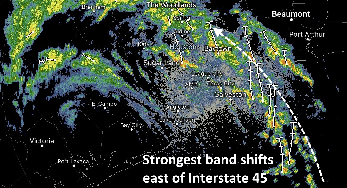
Over the last couple of hours this band, and the strongest inflow of moisture from the Gulf of Mexico has shifted somewhat east, coming across Galveston Bay and into Baytown. These areas have been relatively untouched by Beta’s heaviest rains over the last two days, and can generally handle the rainfall.
Houston radar as of 11am CT Tuesday. (RadarScope)
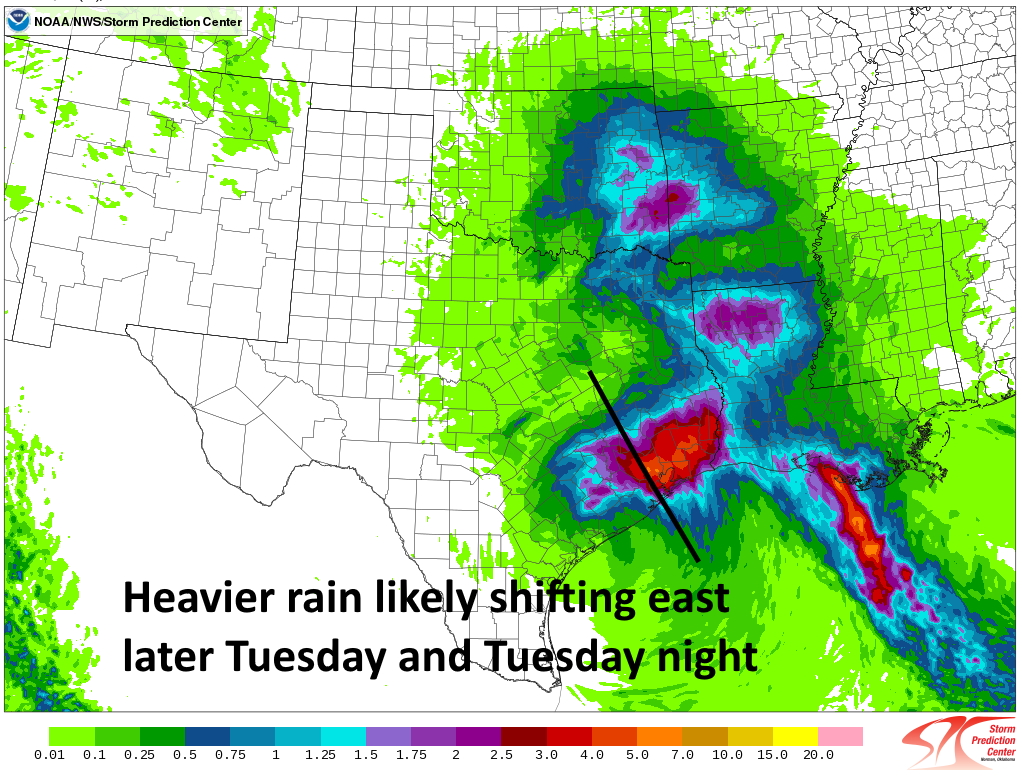
As a result of this shift, the hardest hit communities south and southwest of Houston will see more sporadic, less intense showers as we head into the late morning and, presumably, early afternoon hours. The question is what happens then? Our high resolution forecast models have not performed great, but right now there is a general consensus that this trend will hold. While the greater Houston area will remain at risk for heavy rainfall for the rest of today, by this evening or Wednesday morning the bulk of the activity should shift east of Interstate 45.
Ensemble of convective models for rain totals from 7am CT Tuesday to 7am Wednesday. (NOAA)
So cautiously, I would say the worst is probably over for areas southwest of Houston, including Sugar Land. That may become increasingly true for Pearland and hard-hit communities along the Gulf Freeway as well later today and tonight. Whether that means those areas will pick up another 1 or 3 inches of rain is not clear. This is all subject to change, of course, but at least it does seem consistent with radar trends and the overall setup of the atmosphere.
Our next post will come no later than 4pm CT Monday.
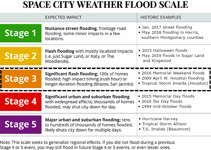
8:10 am CT Tuesday: Effective immediately, we are elevating our Flood Scale alert to Stage 3 for parts of the Houston metro area along, and south of Interstate 10. This is where the heaviest rain should again fall today and perhaps tonight as Tropical Storm Beta continues to pump moisture into the region. For areas further inland, we are maintaining a Stage 1 flood alert.
Space City Weather Flood Scale.
Why did we elevate the risk? For one, Beta produced more rains on Monday and Monday night than we generally anticipated, up to 10 to 12 inches in some locations. While this is not a catastrophic storm yet, it has produced widespread street flooding in central and southern parts of the Houston area. Many roads, including much of Highway 288, are impassable at this time. Residents are strongly encouraged to stay home today. Finally, many bayous in hard hit areas are at or near bankfull, meaning that we could see some home flooding today if heavy rains continue. The best web site to track the water level of your nearest bayou or creek is Harris County’s Flood Warning System.
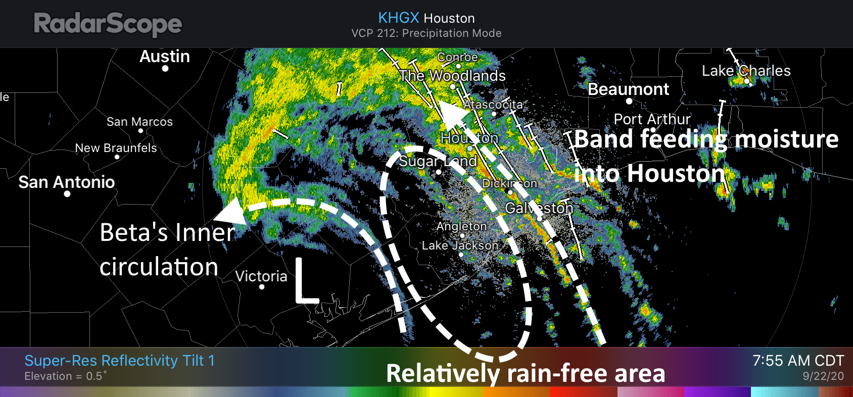
Houston radar snapshot as of 7:55 am CT. (RadarScope)
One of Beta’s strongest bands has again established itself along roughly the Interstate 45 corridor this morning, and this is dragging showers capable of producing 1 to 1.5 inches of rainfall an hour into the city, affecting some already hard-hit areas. This band appears to be lifting slowly north, and behind it there is an area largely free of rain. It’s possible this area of more stable air may move into Houston, providing a bit of a reprieve later this morning. But I’m making no promises on that.
Right now, I would generally expect 2 to 4 inches of additional rainfall across the Houston metro area today, but we cannot rule out higher bullseyes.
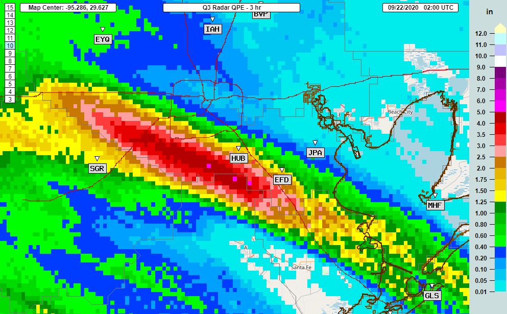
Good evening. Training bands of moderate-to-heavy rainfall from Tropical Storm Beta are continuing to move across the greater Houston area this evening. The heaviest rains from 6 to 9 pm fell generally to the south-southwest of Houston, from Friendswood and Pearland through Sugar Land. A few locations received 4 to 5 inches during this three-hour period and it is starting to back up bayous. Other parts of Houston have largely been spared.
Three hour rainfall estimates for 6 to 9pm CT Monday. (NOAA)
These southern areas appear to have won the Beta lottery this evening with a nearly stationary banding feature that is continuing to feed off moisture from the Gulf of Mexico. The National Weather Service has issued a flood advisory for this general region, suggesting an additional 1 to 2 inches of rainfall may occur over the next several hours. So far, the vast majority of area bayous and creeks remain within their banks. According to Harris County Jeff Lindner, here are the waterways of most concern at the moment:
Lower Keegans Bayou: overbanks at Roark…flooding is ongoing
Willow Waterhole: near bankfull at Westbury
Brays Bayou: water levels are within 2-5 feet of bankfull from Gressner Dr to Rice Blvd
Clear Creek: Near bankfull along the entire channel and overbanks near I-45
Turkey Creek: Within 3 ft of bankfull at FM 1959
Waterways aside, these heavy rains have created a dangerous situation on some area roadways. Tonight is not a great night to be out and about.
My read on the radar is that this prolonged banding feature that has been running up the Gulf Freeway for much of today and this evening, and ultimately bending into Sugar Land and now west Houston, is running out of steam. Offshore, the next band appears to be developing slightly to the north and east, and if this happens it should give some of the region’s aforementioned, hardest hit areas a reprieve in an hour or two.
Our next post will come by or before midnight to see whether I have read the radar correctly.
7:55 pm CT Monday: Tropical Storm Beta is limping toward the Texas coast this evening, at a speed of about 5 mph, and will come ashore near Matagorda Bay tonight. It has maintained sustained winds of 45 mph today, but its overall organizational structure is poor. Now that the storm is nearing land, we should start to see some very gradual improvement in coastal flooding over the next two days. The bigger issue is rainfall, particularly a persistent band of showers up the I-45 corridor this evening.
Track
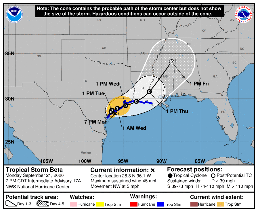
First of all, the most likely track for Beta now is that the storm comes barely inland near Matagorda Bay, and noodles around for pretty much all of Tuesday before beginning to lift to the northeast. Please note it is entirely possible that the center of the storm will slide far enough east that it reemerges over the Gulf of Mexico later on Tuesday or early Wednesday and then scoots up the Texas coast toward Louisiana. If this over-water track happens it will not have much sensible change on our weather in terms of winds and seas. At this point, the near-term track of Beta is almost immaterial—we’ve felt the lash of its winds, and its waves. Now all that’s left is how much rain it puts down over the next two days before exiting stage right.
4pm CT Monday track update for Beta. (National Hurricane Center)
Rainfall
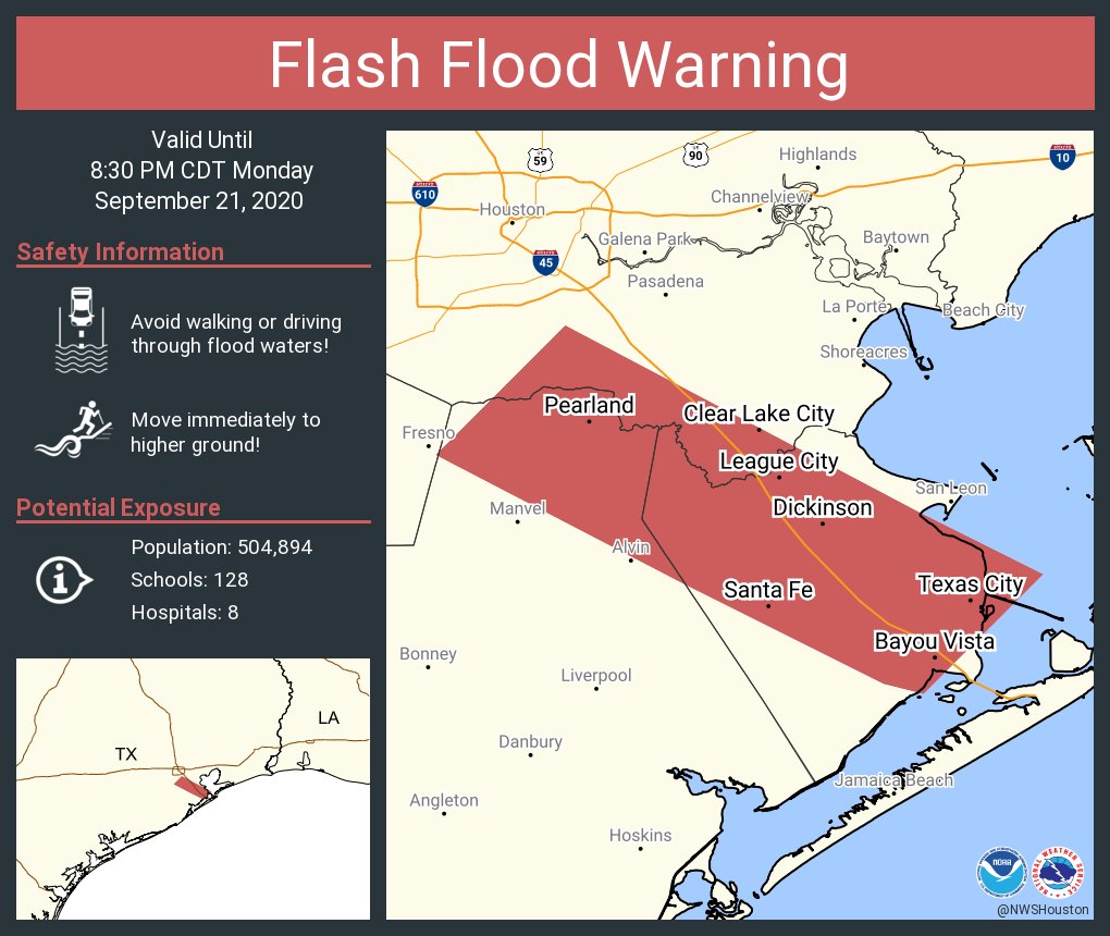
For the most part Beta’s rainfall has been moderate today, and the good news is that most of the storms that have moved through have produced rainfall rates of 0.5 to 1.0 inch per hour. This is within the capacity of our streets and bayous the handle. The one problem area is roughly the Interstate-45 corridor between Galveston and Pearland. Some communities along and adjacent to the freeway have seen in excess of 5 inches today as storms have basically trained over the area since around noon. Even at relatively moderate rainfall rates, these totals add up over time. As a result the National Weather Service has issued a flash flood warning for this area through 8:30pm.
Area of flash flood warning in effect until 8:30pm CT. (National Weather Service)
So what happens this evening and overnight? This I-45 band has slowly been lifting north, so the areas “under the gun” will hopefully get a reprieve later this evening, and we’d expect the heaviest rains to probably fall a little to the east of where they occurred today. However, if the band does not move it could lead to rises on Clear Creek, Chigger Creek, Cowart Creek, and Mary’s Creek—all of which remain comfortably within their banks for now.
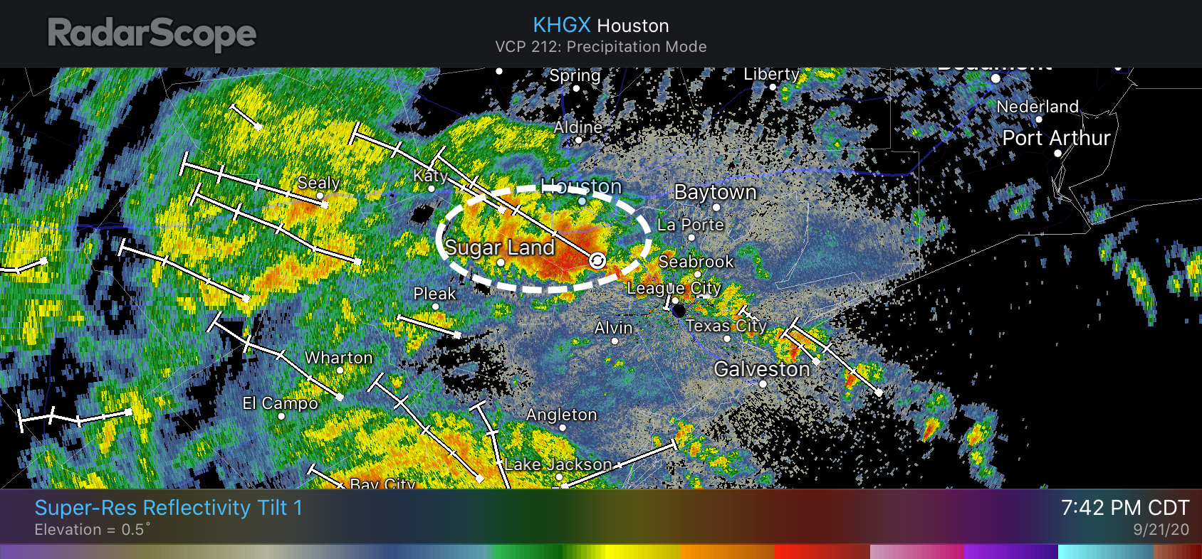
At 7:45 pm another area of heavy rainfall just north of Pearland was pushing into Sugar Land and West Houston. Most of these areas, except for Sugar Land, have generally only see 1 to 2 inches of precipitation so far today, so they can handle the additional rainfall. But these will be strong storms as they push through and need to be monitored for additional development.
Pocket of heavy rainfall headed to the northwest at 7:45pm CT. (RadarScope)
The high resolution models do not have a great handle on trends during the overnight hours, and I want to see what happens with these banding features before hazarding a prediction beyond the next hour or two. Therefore I will update again by about 10 pm CT tonight.
Baby Lanza update
Tropical Storm Beta has brought some wind, some rain, some coastal flooding, and Theodore Kelvin Lanza who arrived a little earlier than we had expected on Sunday night! Mama and baby are doing great. Thanks to all for well wishes and messages. pic.twitter.com/Rld5VBIJ6Y
The company has already secured over 600 plots of land, as well as areas for the stations in Dallas, Houston and the Brazos Valley.
Credit: Brandon Formby/The Texas Tribune
Sign up for The Brief, our daily newsletter that keeps readers up to speed on the most essential Texas news.
The high-speed train that promises to transport passengers between Dallas and Houston in 90 minutes has been approved by the Federal Railroad Administration, according to Texas Central Railroad, the company in charge of the project.
The U.S. Department of Transportation’s Federal Railroad Administration issued the two key rulings, which provide the regulatory framework and the environmental review for the high-speed train, that Texas officials were waiting on to move forward with the project, according to the company. The announcement was first reported by the Houston Chronicle.
Texas Central expects to start construction in the first half of 2021.The federal Surface Transportation Board still must approve the project before construction can begin.
The rulings announced Monday brought cheers from leaders in Dallas and Houston, but criticism from project opponents along the path the train could take to connect the cities.
“This is the moment we have been working towards,” said Carlos Aguilar, CEO of Texas Central Railroad in a statement. “The release of the final (approvals) by the Federal Railroad Administration represents years of work by countless individuals, affirming a very thorough and careful federal regulatory process that will make the Texas Central Railroad the first high-speed rail system to be implemented in the United States.”
The company estimates that the construction for the project will take up to six years, with a total cost of around $20 billion. The train will use the same technology as the Shinkansen bullet trains in Japan, which can reach speeds of more than 200 mph.
The project has seen resistance from property owners in rural areas of Central Texas, where the railroad would travel through. According to Texas Central Railroad, they already have control of over 600 parcels of land — approximately 40% of the parcels they need for the project — as well as sites for stations in Dallas, Houston and the Brazos Valley.
U.S. Rep. Kevin Brady, R-The Woodlands, represents part of the areas affected by the project. In a statement, he said the rulings still don't allow use of eminent domain or for Texas Central to start construction. The Surface Transportation Board needs to approve the construction, but the use of eminent domain is a state matter, according to agency documents. In May, Texas courts ruled in favor of the project and against landowners trying to stop the eminent domain process. A landowner plans to appeal. As of September, the company hasn't needed to use eminent domain.
“The lawmakers, landowners and rural communities along the route who oppose this project look forward to this [STB] application process because we believe it will finally force TCR to publicly disclose their shaky financial projections to the STB, reveal why potential investors have abandoned the project and why taxpayers will likely be on the hook when it ultimately fails,” Brady said.
The company has previously denied that investors have abandoned the project. A spokesperson said that after the approvals from the FRA, they are focused on securing funding and they already have letters of intent from unnamed banks in Japan and Europe for over half of the anticipated debt needed for the project.
State Rep. Ben Leman accused the company of asking for billions of federal dollars and putting up "Texas land as collateral to the Japanese government in the event the project fails." A spokesperson for Texas Central explained that the company gave its lender, a company called Japan-Texas High Speed Railway Cayman LP, a security interest on land it's acquired and said that is typical in real estate transactions. The spokesperson denied that the company has asked for government grants, loans or subsidies.
Several local groups oppose the project. Kyle Workman, president of Texans Against High-Speed Rail, said in a press release that the project will cost more than what is projected.
“Texas Central will likely trumpet this decision as major progress for its project, but they are simply arranging deckchairs on the Titanic," Workman said.
The organization ReRoute The Route, which has called the proposed path “the most dangerous and cheapest option,” criticized the federal government for the decision.
“The Federal Railroad Administration is neglecting its regulatory duty to protect Americans from life-threatening projects like the proposed high-speed rail project in Texas,” organization spokespersonTaylor Ward said via email. “This project has been flawed from the beginning and the FRA has ignored calls from concerned property owners, safety professionals, and even other rail companies.”
But leaders in Dallas and Houston have defended the high-speed railroad and worked with the company to secure areas to build stations and lines.
“Today’s announcement from Texas Central means that this landmark project is closer than ever to breaking ground. The construction of high-speed rail will have a generational impact, creating thousands of jobs right here in Houston and injecting billions of dollars into our local businesses,” said Houston Mayor Sylvester Turner in a statement. “Once operational, the system will create connections and opportunities never thought possible.”
At the other end of the line in Dallas, Mayor Eric Johnson repeated his support for the project.
“High-speed rail will be a major part of the future of transportation in Texas, and it will be transformative for the city of Dallas,” Johnson said in a statement. “I am thrilled by the announcement of Texas Central’s latest historic milestones, and I am proud to advocate for this project, which will create thousands of jobs in Dallas, attract new businesses, and strengthen our economy for years to come.”
Texas Central has been a financial supporter of The Texas Tribune, a nonprofit, nonpartisan news organization that is funded in part by donations from members, foundations and corporate sponsors. Financial supporters play no role in the Tribune's journalism. Find a complete list of them here.
The CDC says the guidelines were posted to its website in error. The now-deleted updates were notable because so far the agency has stopped short of saying that the virus is airborne.
8:50 pm CT Sunday: Good evening folks. Matt started this post earlier, but Eric is stepping in to finish it due to a family matter. Read to the end to find out what took Matt away—and you’ll understand the lengths to which we’ll go to make sure we’ve got Houston covered in times of severe weather!
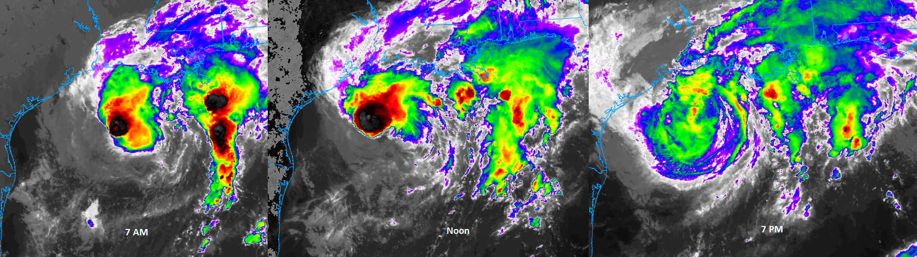
It’s been interesting to watch the evolution of Tropical Storm Beta today. The storm looked terrible this morning, had a renaissance this afternoon, and has now reverted back to mostly unimpressive, but standard tropical storm fare. You can see how it has progressed on satellite through the day, from morning thunderstorms with an exposed center to afternoon storms under a consolidated looking center to a broad, weaker looking storm this evening.
Beta’s evolution today has led to it looking fairly different at times but packing mostly the same punch as it had when the day began. Click to enlarge. (College of DuPage)
All in all Beta is who we thought it was: A moderate tropical storm fighting shear and dry air but occasionally feeling the hospitality of a warm Gulf of Mexico. We expect only slight changes, if any, in intensity over the next day or so as it nears the Texas coast and likely comes ashore on Monday.
Beta’s forecast track and intensity is very little changed this evening versus where it was 12 to 18 hours ago. The storm picked up a little forward speed today and is currently about 150 miles east-southeast of Port O’Connor and the entrance to Matagorda Bay. Beta will move generally west or west-northwest through the night and into tomorrow, eventually making landfall by around Noon tomorrow, give or take. After this the storm will eventually turn to the northeast, perhaps passing near Houston over land, or offshore. During this time it should gradually become more disorganized. It should be gone by Wednesday or Thursday. Good riddance!
Rainfall
In terms of precipitation, we’re still in the same place we’ve been for awhile with our Flood Scale. We have a Stage 2 flood alert for coastal areas south of Interstate 10, and a Stage 1 event for areas north of Interstate 10. Neither the global models or the regional models that can better model convective storms are showing really aggressive rainfall totals that would lead to significant widespread flooding this week.
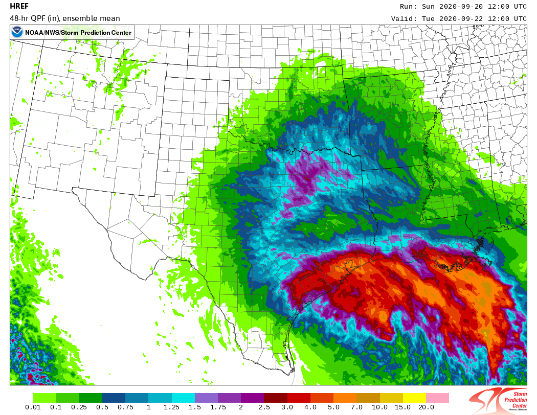
Regional convective model forecast for rainfall through Tuesday morning. (NOAA)
Beta’s heaviest rains should come between Monday morning and Wednesday morning, and some of our best regional models suggest a reasonably healthy band of showers could move into Houston around sunrise tomorrow. (We’ll see). We generally expect 2 to 8 inches of total additional rainfall across the region, with higher isolated amounts, and our greatest concern is pockets that may see the majority of that rain in a couple of hours. This should generally cause street flooding, but we’ll be watching closely for trouble spots.
Wind speeds
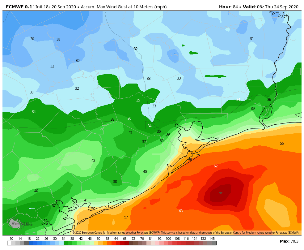
We’ve been tracking winds this evening, and there have been some gusts near tropical storm-force along Galveston Island. We think winds will probably pick up a little bit more during the overnight hours before beginning to back off Monday morning. Most of the Houston area—and certainly locations north of Interstate 10—are unlikely to see prolonged tropical storm-force wind gusts from Beta. Here’s a look at the European model’s forecast swath of maximum wind gusts from the storm.
European model for maximum wind gusts in Houston this week. (Weather Bell)
Sustained winds will be lower. This should not be enough to cause significant electricity problems for inland areas, although we may see some power outages right along the coast.
Coastal surge
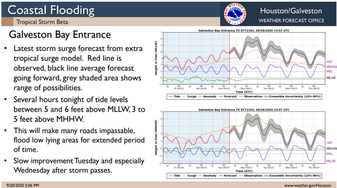
The most dramatic effect our region has seen from Beta has been rising waters along the coast due to the storm’s easterly winds and surge. We expect the highest levels to occur with high tides this evening along the coast, and again on Monday morning. Very high water levels will persist into Tuesday before really beginning to ramp down on Wednesday. We have already had reports of many low-lying roads on Bolivar Peninsula and the West End of Galveston Island becoming impassable.
Coastal flooding outlook for Galveston. (National Weather Service)
Our next update will come no later than 7:30am CT Monday.
Matt’s end note: I’m about to become a father for the second time, and nature called upon us this evening. I’ll be taking a break from the site for a little while for obvious reasons, but will pass along the good news when possible! Stay safe!
Sen. Elizabeth Warren forcefully condemned the Senate Majority leader at the vigil: "What Mitch McConnell does not understand is this fight has just begun."
![(c) You can have a scooter when you pay for it yourself, and (d) if you can't learn to start a new thread rather than responding to an old one, you'll be banned. [thread locked by moderator]](https://imgs.xkcd.com/comics/message_boards.png "(c) You can have a scooter when you pay for it yourself, and (d) if you can't learn to start a new thread rather than responding to an old one, you'll be banned. [thread locked by moderator]")













/https://static.texastribune.org/media/images/2017/02/22/HSR_02.JPG)