We knew that the James Webb Space Telescope would find interesting stuff, especially about the mysterious early times. For example, there are hints that the galaxies we’re seeing are brighter and more regular than expected given the short amount of time they’d had to grow. Well, perhaps no one was expecting that we’d find a completely new type of star—one mostly made of and powered by dark matter and shining as bright as an entire galaxy. Which, by the way, might help us explain those pesky giant galaxies.
Hosted by Matt O'Dowd Written by Matt Caplan & Matt O'Dowd Post Production by Leonardo Scholzer, Yago Ballarini, Adriano Leal & Stephanie Faria Directed by Andrew Kornhaber Associate Producer: Bahar Gholipour Executive Producers: Eric Brown & Andrew Kornhaber Executive in Charge for PBS: Maribel Lopez Director of Programming for PBS: Gabrielle Ewing Assistant Director of Programming for PBS: John Campbell
Big Bang Sponsors Bryce Fort Peter Barrett David Neumann Sean Maddox Alexander Tamas Morgan Hough Juan Benet Vinnie Falco Fabrice Eap Mark Rosenthal
Quasar Supporters Glenn Sugden Alex Kern Ethan Cohen Stephen Wilcox Mark Heising
Hypernova Supporters Stephen Spidle Chris Webb Zachary Wilson Kenneth See Gregory Forfa Joe Moreira Bradley Voorhees Scott Gorlick Paul Stehr-Green Ben Delo Антон Кочков Robert Ilardi John R. Slavik Donal Botkin Edmund Fokschaner Chuck Zegar Jordan Young Daniel Muzquiz
Gamma Ray Burst Supporters Robin Bayley Piotr Sarnicki Massimiliano Pala Thomas Nielson Joe Pavlovic Ryan McGaughy Chuck Lukaszewski Edward Hodapp Cole B Combs Andrea Galvagni Jerry Thomas Nikhil Sharma Ryan Moser John Anderson David Giltinan Scott Hannum Bradley Ulis Craig Falls Vivaan Vaka Kane Holbrook Ross Story teng guo Mason Dillon Matt Langford Harsh Khandhadia Thomas Tarler Susan Albee Frank Walker Matt Quinn Michael Lev Terje Vold James Trimmier Jeremy Soller Andre Stechert Paul Wood Kent Durham Ramon Nogueira Paul Suchy Ellis Hall John H. Austin, Jr. Diana S Poljar Faraz Khan Almog Cohen Daniel Jennings Cameron Sampson Jeremy Reed David Johnston Michael Barton Andrew Mann Isaac Suttell Bleys Goodson Robert Walter Mark Delagasse Mark Daniel Cohen Shane Calimlim Tybie Fitzhugh Eric Kiebler Craig Stonaha Frederic Simon Tonyface John Robinson Alex Gan David Barnholdt David Neal John Funai Bradley Jenkins Vlad Shipulin Cody Brumfield Thomas Dougherty King Zeckendorff Dan Warren Patrick Sutton John Griffith Dean Faulk
For those of you just interested in the Atlantic & Gulf activity, scroll down. We will begin again today with Hurricane Hilary. For folks in California, charge your phones, as power outage risks will increase today with Hilary coming north.
Some people will be apt to call this a “bust” already. As those of us in Houston know all too well, when round one of rain ended and the sun even came out for a time, a lot of people were caught off-guard by Harvey’s main event that night. Hope for the best, but the forecast data has not markedly changed and severe impacts remain a likely outcome, especially in the desert.
One-sentence summary
Hurricane Hilary is expected to impact the Desert Southwest today with extremely heavy rain and a high risk of significant flooding, while South Texas eyes beneficial rains from a tropical wave this week, one of several Atlantic disturbances right now.
Hurricane Hilary: Still likely to bring severe rain & flooding to the desert
The majority of the forecast is on track, with a few noteworthy changes today, mainly in the form of higher wind forecasts in southeast California, Nevada, and southwest Arizona. Hilary is approaching the coast of Baja this morning with its 85 mph winds, mostly as expected.
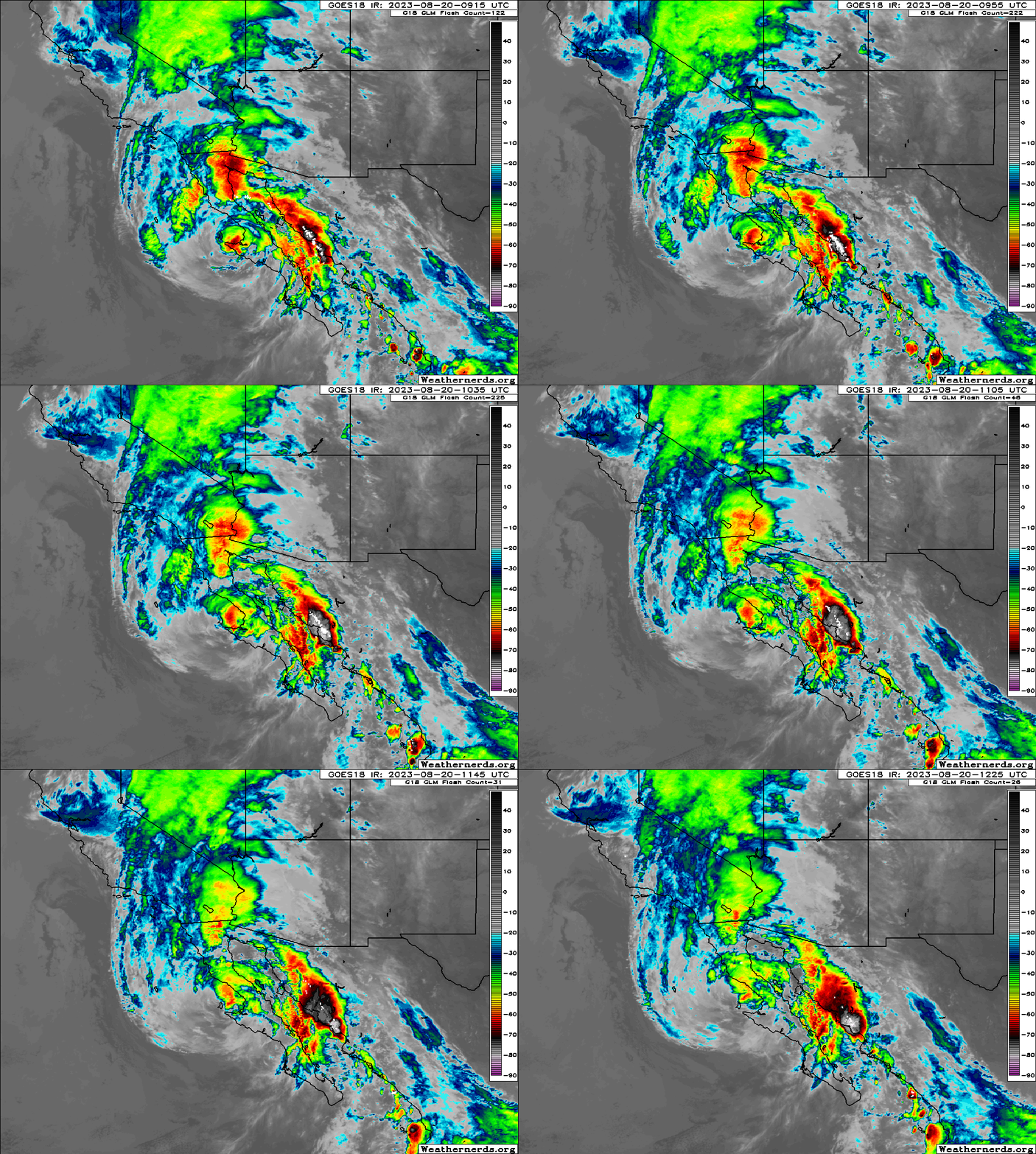
Hilary should make landfall somewhere in northern Baja later this morning or this afternoon. Moisture extends well out ahead of it, and tropical moisture will arrive in the Southwest today. (Weathernerds.org)
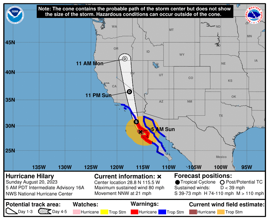
Very little has broadly changed in terms of the track, but a few nuances lead to a little more wind for the Southwest U.S. Hilary should come north as a tropical storm into California, transitioning to a depression near Death Valley, and then getting absorbed into the U.S. weather pattern over Nevada.
Hilary will maintain tropical characteristics deep into the Southwest U.S., before becoming “post-tropical” over the Great Basin. (National Hurricane Center)
Let’s walk through impacts again today.
Coastal SoCal Metros (Santa Barbara-Ventura-LA-OC-San Diego)
For most in these areas, Hilary will be a considerable inconvenience. However, there will be issues with flooding in spots. There will also be concerns about mudslides and debris flows in the foothills and near burn scars. While the majority of valley and coastal locations will see 1 to 3 inches of rain, that will be enough to cause flash flooding of roads, and travel later today may become a little difficult. Urban flooding is always a concern when you get rain rates of an inch an hour possible, which may be what occurs in spots.
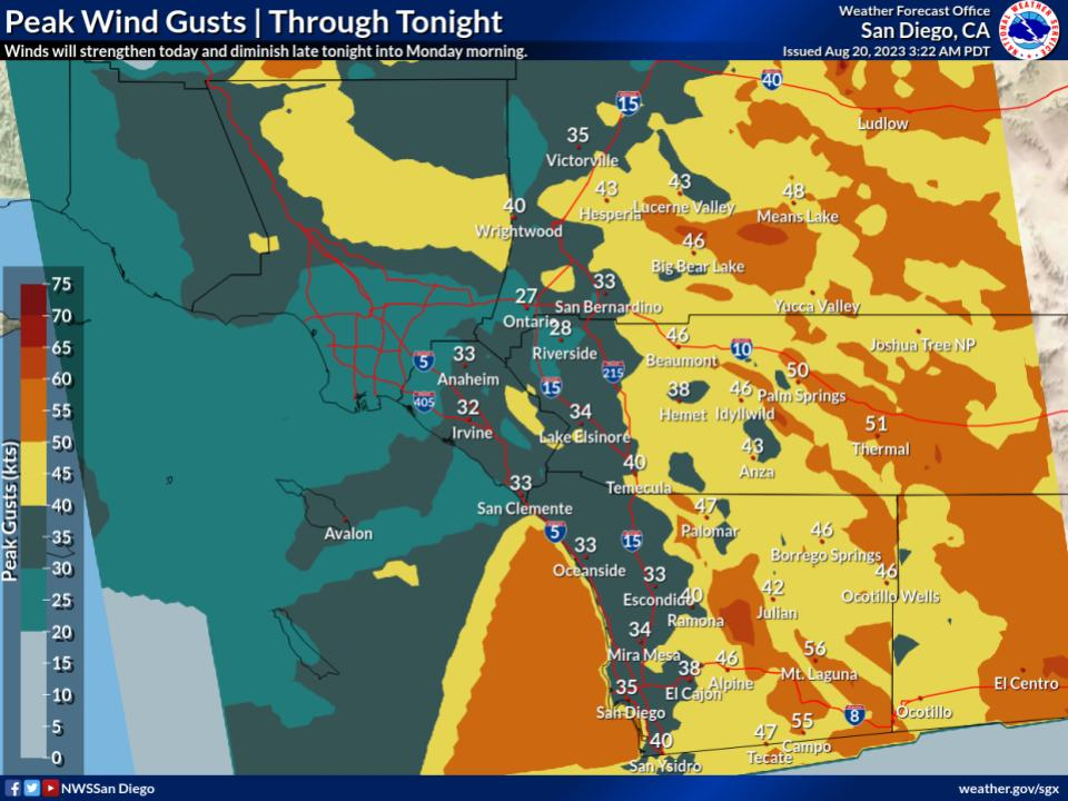
Wind gusts will peak in coastal SoCal later this morning and this afternoon into evening as Hilary comes north. Power outages are likely in spots. (NWS San Diego)
Flood watches are posted, and honestly if you don’t need to be out later today, it’s best to stay put.
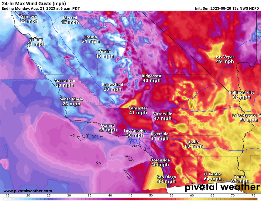
While winds may not look dramatic on the map above (with 30 to 40 mph wind gusts on the coast), there will be stronger winds in spots and likely some power outages.
Conditions from Santa Barbara through San Diego will improve tomorrow.
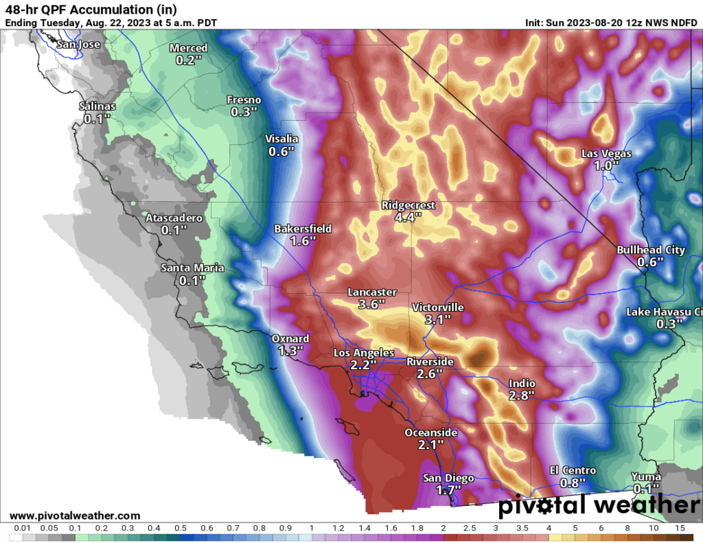
Rainfall will range from 1-3″ between Ventura County and San Diego. Higher totals are likely in the mountains and deserts and in localized spots.
Inland SoCal Metro Valleys and Mountains
The impacts inland from the coast will vary. North and east-facing mountain slopes will likely see the heaviest rainfall with 3 to 10 inches likely and higher amounts not out of the question. Rate rates will be intense, and in those particular mountains, we may see mudslides, rock slides, and the potential for significant, rapid-onset flooding. This will include the mountains east of San Diego, the north side of the San Gabriels, San Bernardinos, and Ventura County mountains. The Antelope Valley north of LA may be very susceptible to flooding due to rain in the mountains upstream.
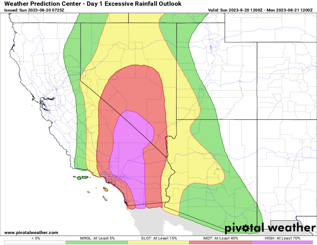
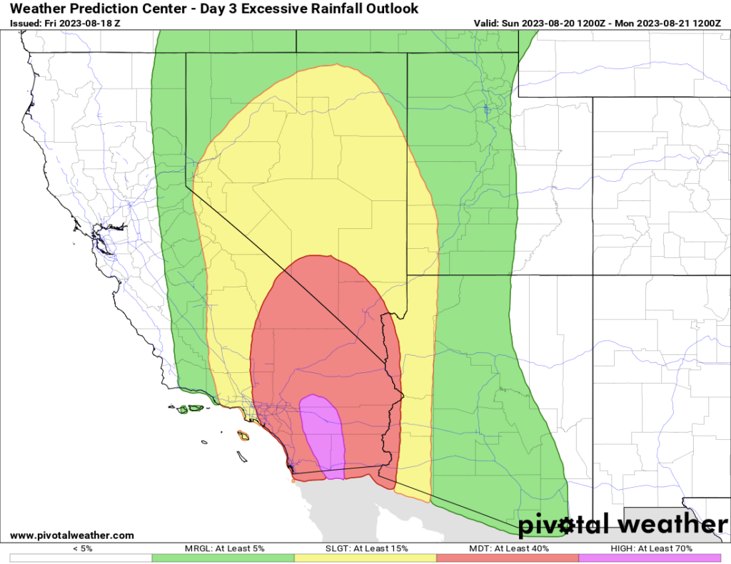
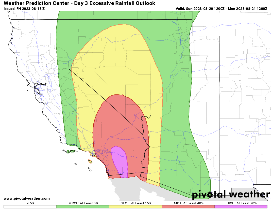
A “high” risk of excessive rainfall and flooding is in place today for the eastern half of San Diego County into Palm Springs, the Antelope Valley, Morongo Basin (including Joshua Tree), much of the Mojave Desert, Death Valley, into Nye County, NV/the Amargosa Desert. (Pivotal Weather)
Flash flooding or debris flows will be likely in some of the foothills and mountains, and travel, particularly into the mountains or across the Antelope Valley will be discouraged later today.
Winds will mimic patterns that we usually see in these regions during Santa Ana wind events, with gusts locally up to 50, 60, or 70 mph possible. This isn’t a Santa Ana, but because the wind direction of an approaching tropical storm is similar to how winds setup in Santa Anas, you’ll get that pattern. Prepare for power outages in some of these areas.
California Deserts
As noted above, the Antelope Valley will be particularly susceptible to heavy rainfall, but the Mojave Desert as a whole will be as well. That high risk from the NWS Weather Prediction Center remains in effect today, as it has since a few days ago. Confidence is high in major, damaging flooding impacts in these areas, which may see the equivalent of a year or more worth of rain today. Areas from the Imperial Valley and Salton Sea north to Death Valley are at highest risk for poor outcomes today. Locally, mountain peaks will enhance rainfall some, including the Panamints near Death Valley. Travel is discouraged today in the deserts and between the coast and interior.
Winds will also be an issue here, with 40 to 60 mph gusts widespread and risk for higher in spots. Prepare for power outages in these areas.
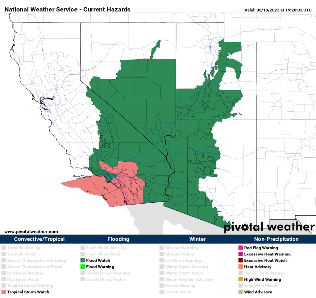
Tropical storm and high wind warnings are in effect for most of Southern California, including the deserts, with gusts of 40 to 60 mph and higher likely in some of the interior areas. (Pivotal Weather)
Arizona
Conditions tend to lessen some in Arizona, but there will still be issues with flooding and strong winds in the western part of the state.
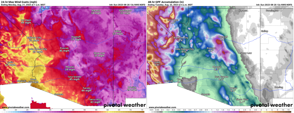
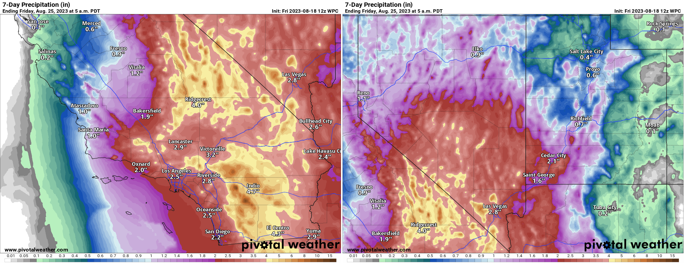
Strong winds are likely in southwest Arizona, and power outages are a possibility in these spots. Rain totals (right) don’t look impressive, but there will be pockets of heavier rain and flash flooding possible, perhaps in some of the mountains north of Phoenix or in and around the Colorado River above Lake Havasu City. (Pivotal Weather)
Rain totals were dropped a good bit near Yuma today, as it appears a “dry slot,” or an area of dry air in between rainy bands may set up near Yuma.
Nevada
For Las Vegas, the threat of flash flooding is real, even if the highest risks are to the west of there. Urbanized desert is especially susceptible to flooding, so if a cell or band of heavy rain just happens to set up over the Las Vegas Valley, you will have a recipe for significant urban flooding. Be aware and prepared today in Vegas.
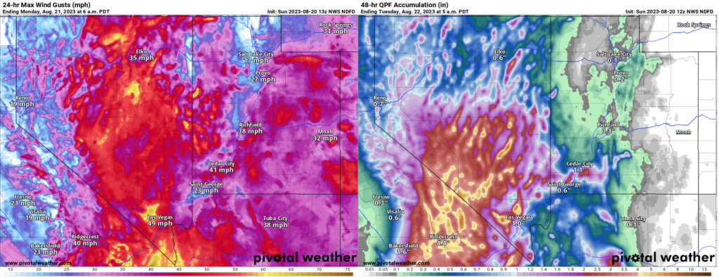
Heavy rains will be likely in Nye County in particular from Hilary. Significant flash flooding is possible there. Strong winds will extend well north into the Great Basin as well. (Pivotal Weather)
The heaviest rain may occur near Mount Charleston. As the NWS in Las Vegas noted this morning, the Nevada 24 hour state rainfall record previously occurred there. The 7.78 inch total on Mt. Charleston may get challenged today.
In addition to the rain, strong winds will be an issue here as well and power outages are possible in southern Nevada.
Conditions should improve from south to north tomorrow.
Lots of Atlantic nuisance and noise
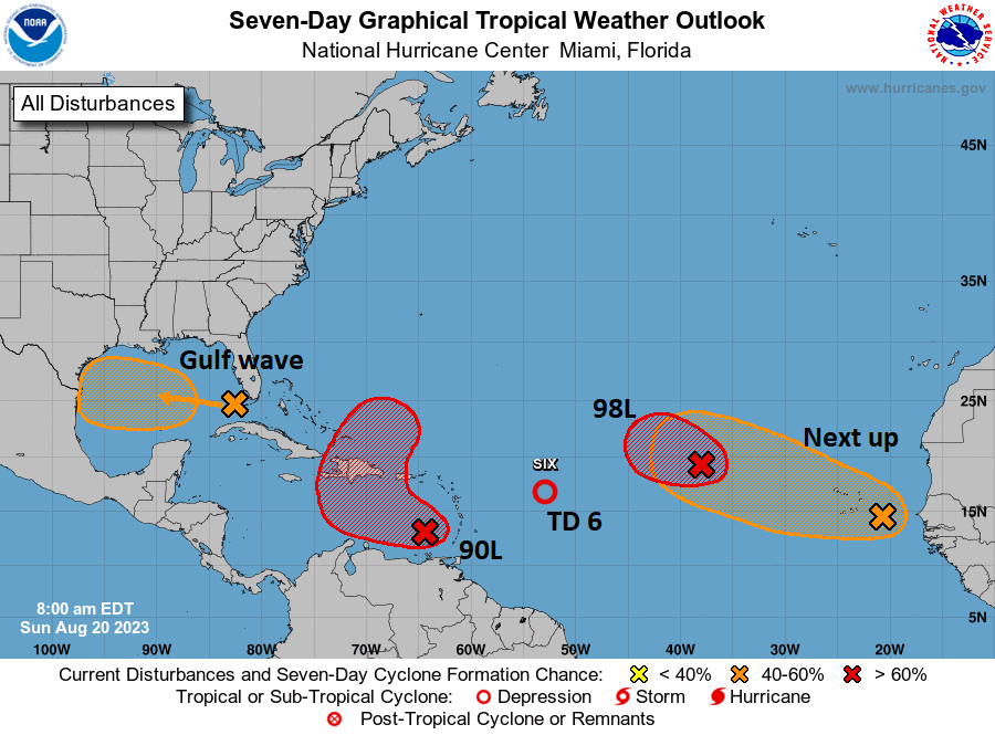
Shifting into the Atlantic basin now. The NHC’s outlook map looks more like a leaked flag football playbook or something.
There are a lot of items on the outlook map today, but none of them look particularly serious in terms of impacts. (NOAA NHC)
Right out of the gate, let me just say that none of these systems look particularly menacing or troublesome for any areas. Busy as it may be, we’ll call this a nuisance setup. Let’s walk through these things.
Gulf wave: A rainmaker in South Texas
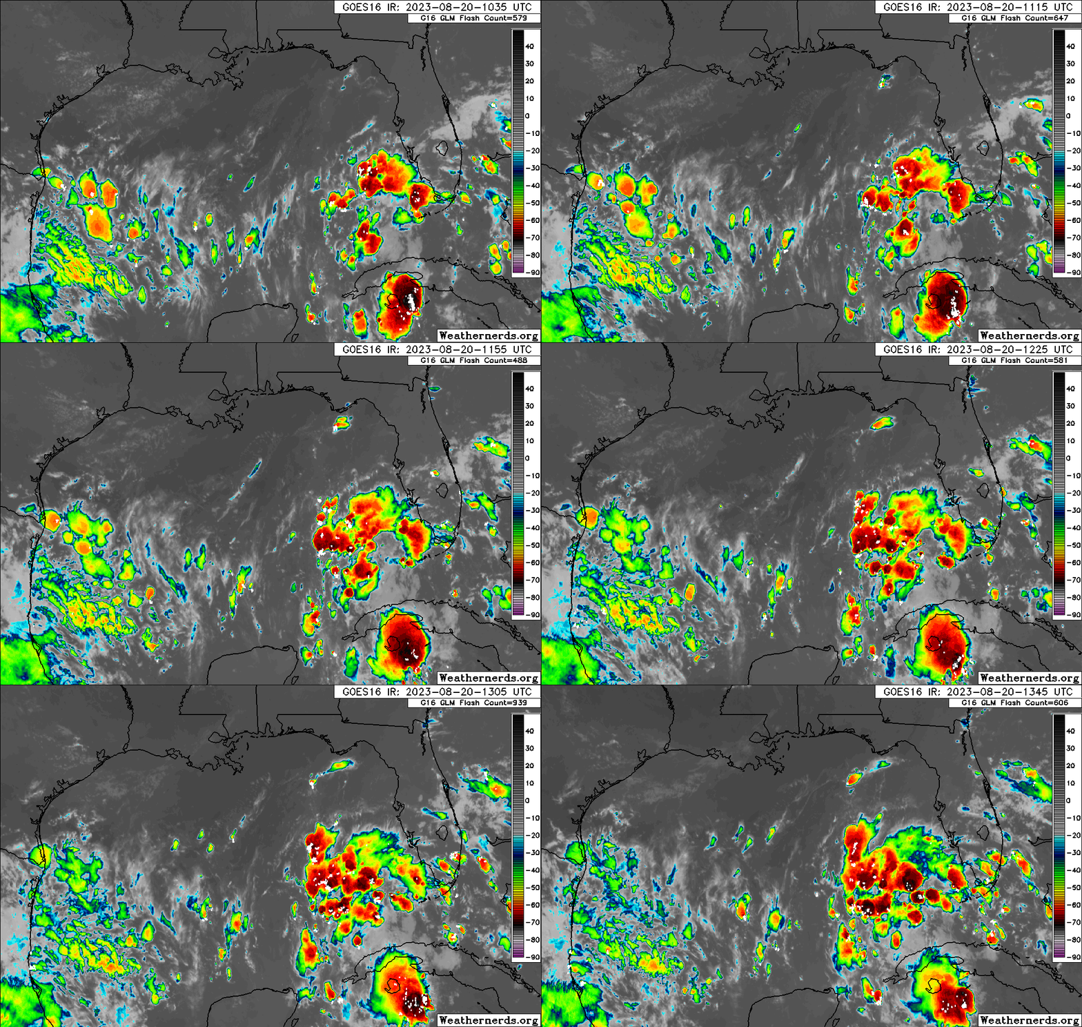
The tropical wave we’ve been talking about for several days is finally in the Gulf of Mexico this morning, and based on satellite imagery, it is not terrible looking. Organized, no, but vigorous, yes.
A tropical wave in the Gulf with a 50% chance of developing over the next couple days is robust looking but disorganized for now. (Weathernerds.org)
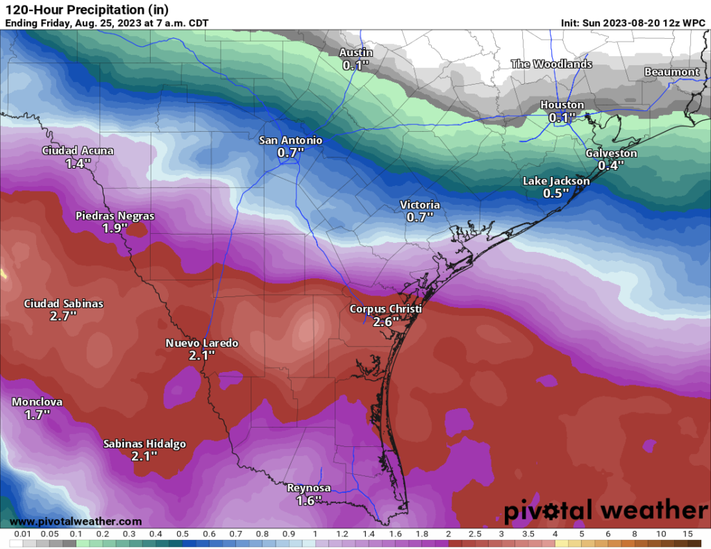
This will continue due west across the Gulf and make it into Texas by Tuesday morning. This has a 50/50 shot of becoming a depression or low-end tropical storm as it approaches Texas, but it is unlikely to surpass that level. The main impact from this system will be rainfall in Texas, a needed commodity. Sadly, for Houston and drought-stricken east Texas, this will do next to nothing. However, South Texas needs the rain too, and they will get some as this system moves in.
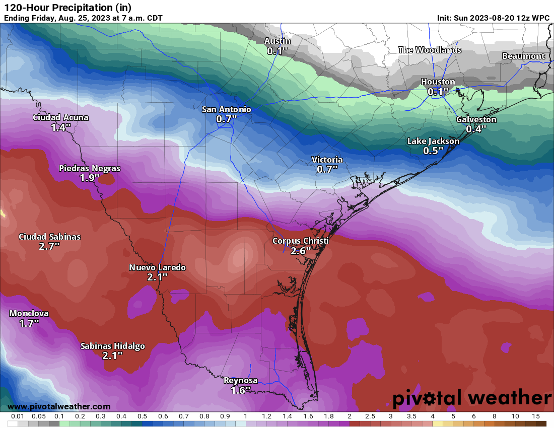
1 to 3 inches of beneficial rain is expected for South Texas, including Corpus Christi into Laredo and across northern Mexico. (Pivotal Weather)
Look for about 1 to 3 inches of rain for areas south of Matagorda Bay and lesser amounts north of there, to near 0 rain for the I-10 corridor in Houston and SE Texas.
Invest 90L: May develop today, rain for Hispaniola, Bermuda in the future?
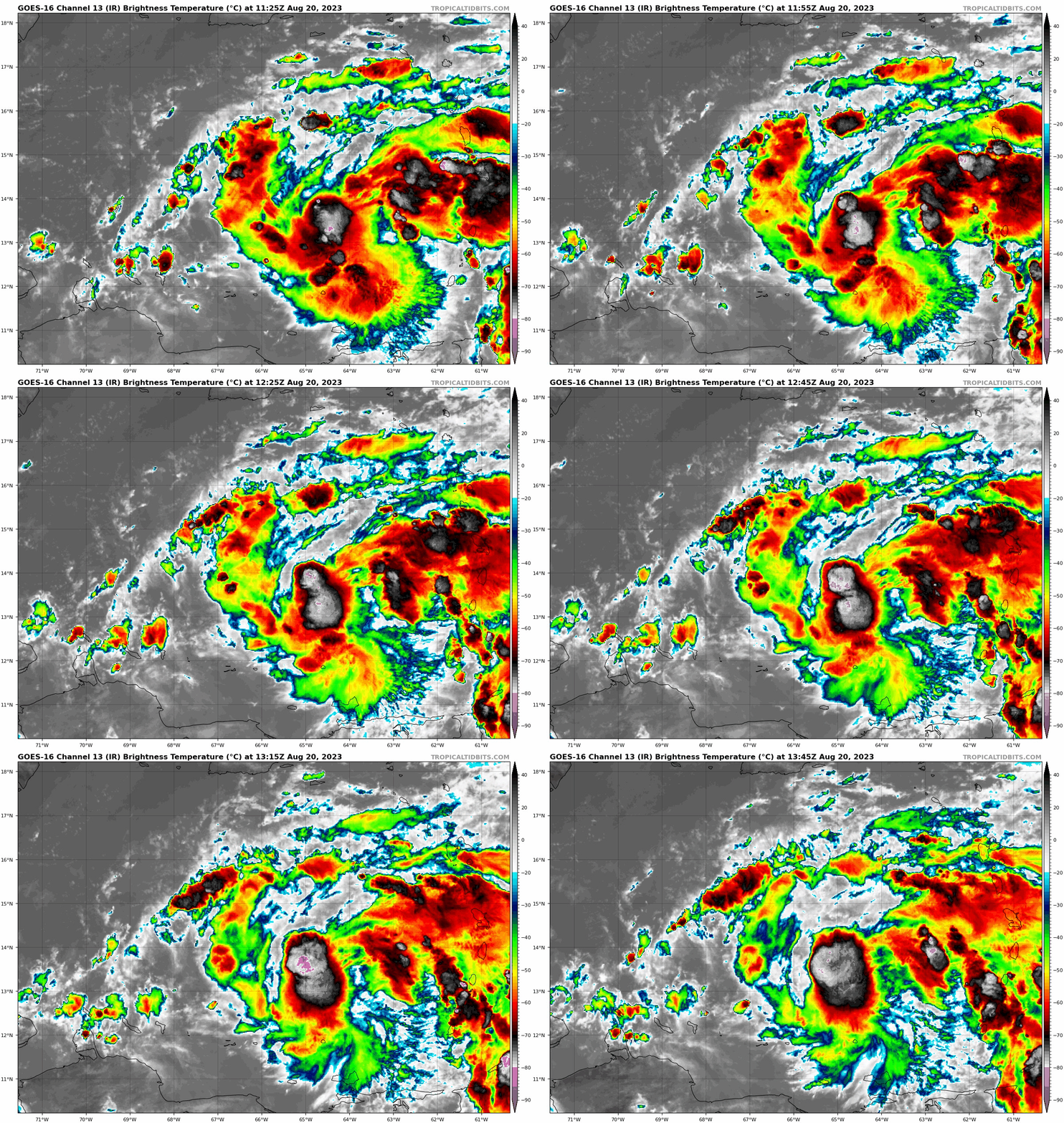
The next wave to discuss is Invest 90L, which is located in the southeast Caribbean. It is beginning to attempt to develop there, and there’s some chance this becomes a depression or even Tropical Storm Emily today.
A robust tropical wave in the southeast Caribbean has a good chance at becoming a depression or storm in the next 24 hours. (Tropical Tidbits)
If you look at the NHC map above, you can see how 90L’s potential development takes on an “L” shape. The good news is that 90L should be drawn up north and out to sea rather quickly. The bad news is that it could impact Hispaniola, particularly with heavy rainfall. Bermuda may also want to keep an eye on 90L’s progress over the coming days. We will watch this closely for those areas this week.
Tropical Depression 6: Heads for the exits today
Invest 99L turned into TD 6 yesterday, and it will degenerate back into a wave today. Thanks for joining us.
Invest 98L & Africa waves
We expect development of Invest 98L in the next day or so, at least to a depression, maybe a tropical storm. But it will stay out at sea. Subsequent waves off Africa will likely behave similarly in the coming days.
Morning forecast models continue to underscore the seriousness of the flooding threat facing the Southwest via Hurricane Hilary’s abundant rainfall.
Happening now: Hilary holds as a major category 4 storm
Hurricane Hilary remains a powerful Category 4 storm. It has about 12 to 18 hours left before ocean conditions begin to cool, which should allow for Hilary to weaken somewhat as it comes north.
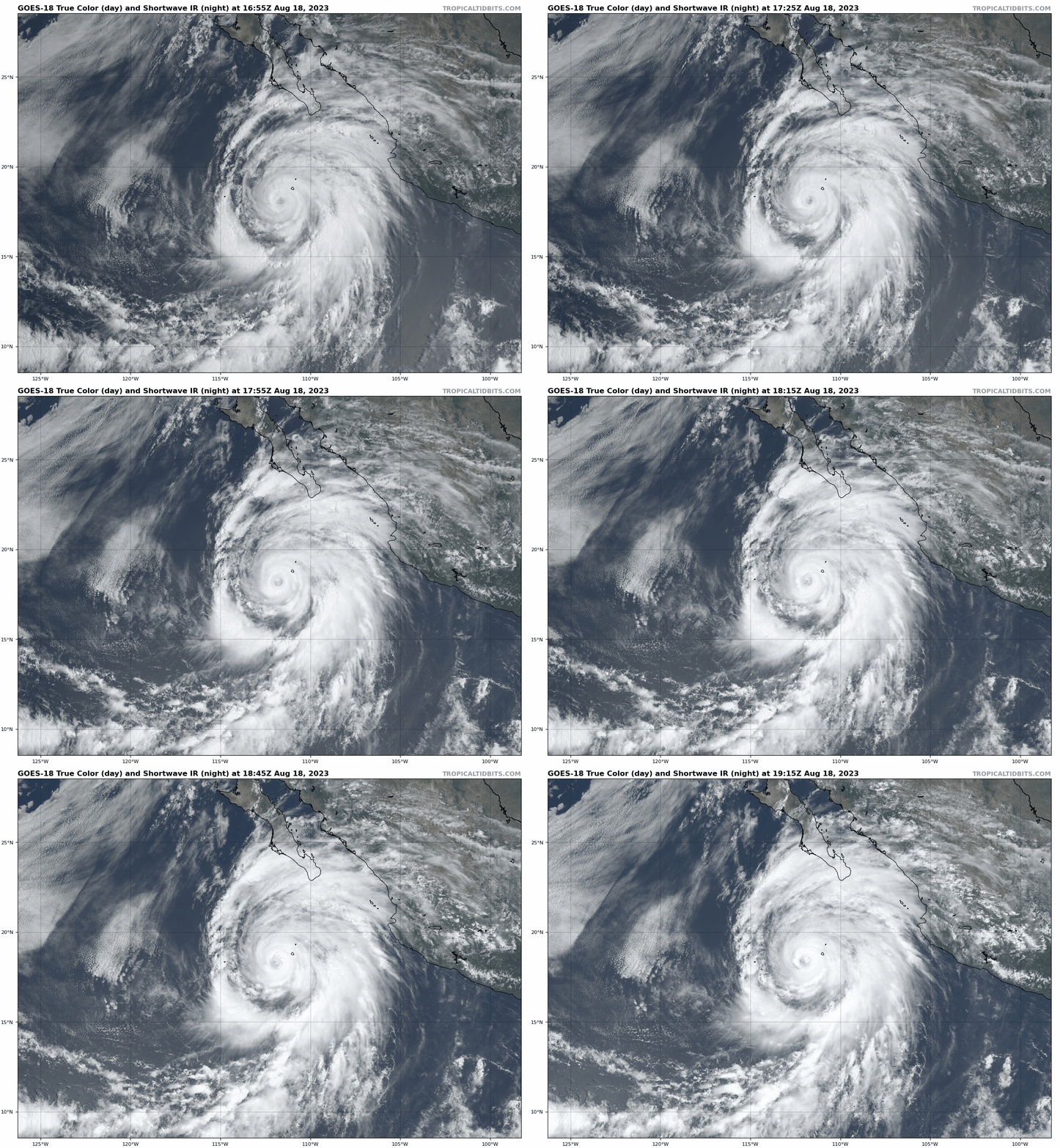
Hilary is close to a textbook looking storm as it turns northwest off the coast of Mexico. (Tropical Tidbits)
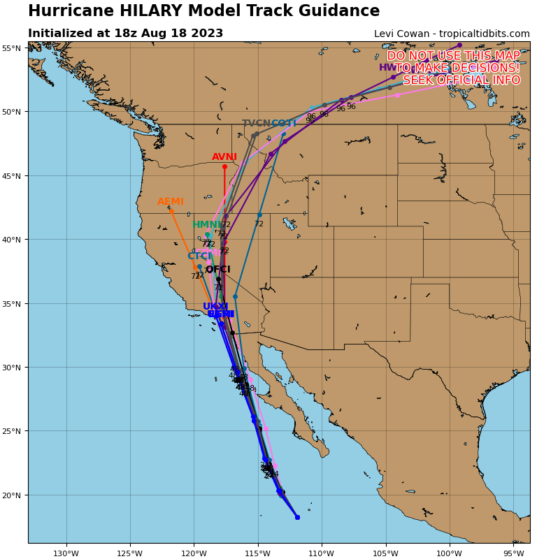
Hilary’s forecast track has not changed too terribly much so far today. In fact, one could argue that aside from a little nuance, Hilary’s future track is now mostly locked in and likely has little deviation expected.
Despite a little nuance, Hilary’s track is mostly locked in for the next 48 hours, with a path just off Baja, comfortably west of Cabo, and hurricane conditions possible in central or norther Baja as Hilary treks close by. Hilary is likely to make landfall near San Diego as a tropical storm on Sunday night or Monday morning. (Tropical Tidbits)
The message for folks in northern Baja, southern California, Nevada, and far western Arizona is pretty clear: While there may be a few details-oriented changes between now and Monday, the overall impacts you should expect will likely change very little. In other words, what you see (now) is what you (should) get.
The rain risk in the Southwest: It is very serious
I don’t want to bury the lede here. While there will be tropical impacts, including and especially to parts of Baja, the main and most severe impacts from Hilary will likely be in the form of flooding and extreme rainfall in the Desert Southwest. We don’t take these situations lightly, and if you’re new to our coverage, you might ask why we’re writing so aggressively about this. In the current media landscape, they’re valid questions, but in this case the answer is that this actually isthat serious.
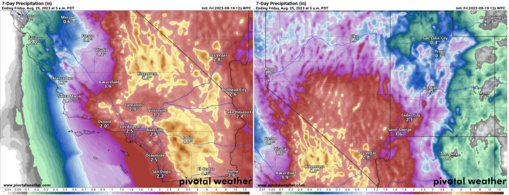
Click to enlarge the rainfall forecast through next week for California, Nevada, and parts of Arizona. (Pivotal Weather)
The current rainfall forecast for Indio, CA is about 4.7 inches. In a typical year, Indio expects just under 3 inches of rain. So, this is a place that already struggles to handle rain and has a chance to see more than its annual average rainfall over 2 days. This is exactly why the Weather Prediction Center issued their first high risk in this region for excessive rain on Sunday. As a Houston-based forecaster who has worked closely with the WPC and their rainfall products, I can assure you that issuing a day 3 high risk is not a decision they take lightly.
The day 3 high risk for excessive rainfall is a rarity to begin with, let alone in the California desert. (Pivotal Weather)
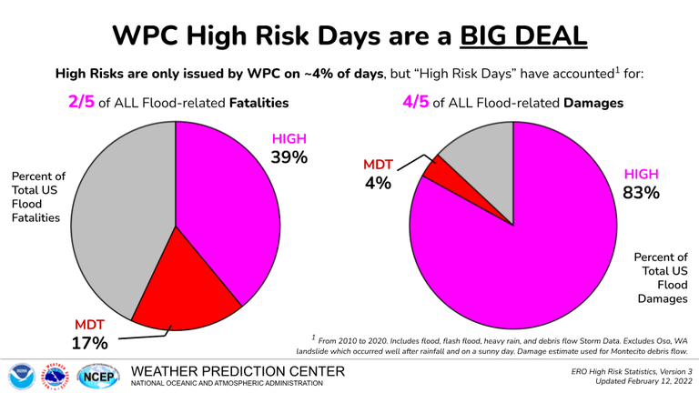
They issue high risks only when they are very confident that what they think will happen will happen. High risk rainfall days are associated with most of the flood damage that occurs in the United States.
Over 80 percent of all flood-related damage in the U.S. occurs on high risk forecast days. (NOAA WPC)
So I just want to be clear with folks that this is a big deal. If you live in the Coachella Valley or Palm Springs in particular, as well as “downstream” from any burn scars in SoCal, you need to be prepared for flooding Sunday or Monday. Travel between Vegas, Phoenix, or northern Arizona and LA may very well be disrupted in spots on I-15, I-40, or I-10 due to desert flooding. Same goes for I-8 between Yuma and San Diego. The area between Mexicali and Palm Springs is at highest risk, but there will be pockets of flooding elsewhere, including in the major metros on the coast (LA and San Diego), as well as in Yuma and Las Vegas. Please heed warnings from your local NWS offices. Now is a good time to get to know their websites and follow them on social media.
But the tropical storm part is cooler!
Some of you may be excited by the fact that a tropical storm is coming and big winds and big surf are on the way. And in fact, for the first time since they’ve been issued by the U.S. government, a tropical storm watch was posted today between the US/Mexico border and the Orange/LA County line, as well as Catalina Island. The hurricane warnings are confined between Punta Abreojos to Punta Eugenia in central Baja.
The watch and warning situation in the Southwest as of Friday afternoon. (Pivotal Weather)
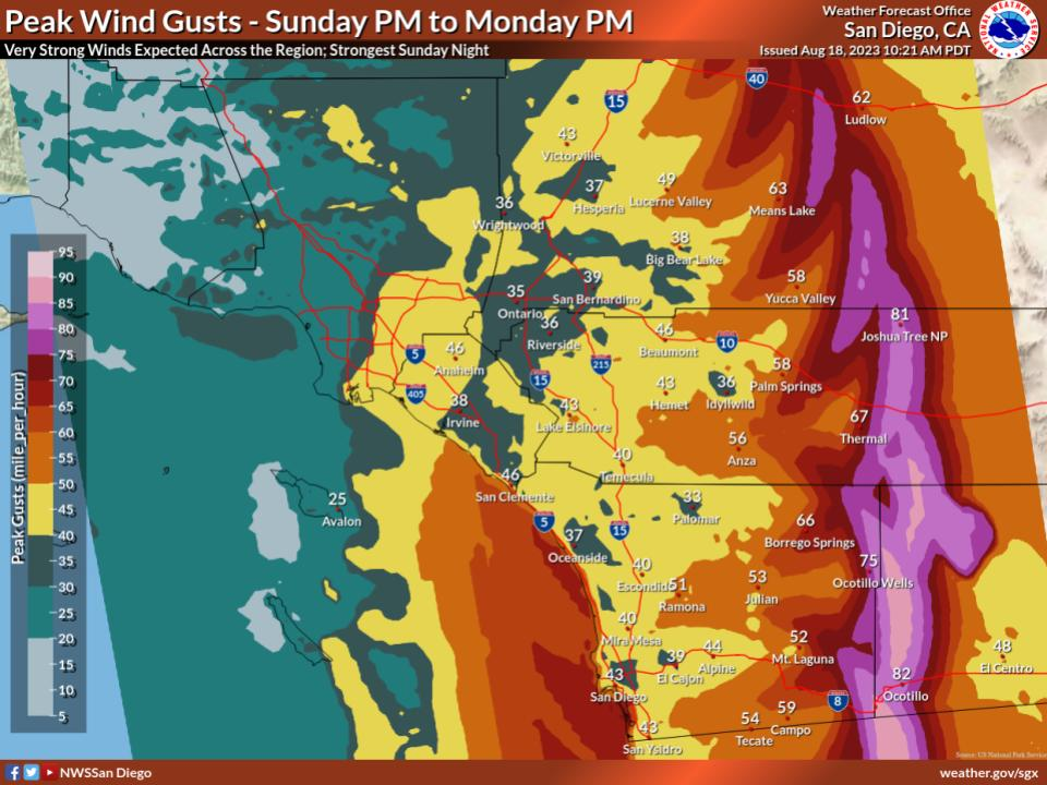
The max wind gusts expected aren’t terrible in the major cities of SoCal, with both Los Angeles and San Diego likely to see gusts as high as about 40 mph or so, perhaps a bit stronger on the coast of Orange County or in the North County portion of San Diego and just offshore. Gusts will likely pick up in the mountains and then be at their worst in portions of the desert over a narrow but long-ish region between Ocotillo and Joshua Tree up toward Baker on I-15.
Maximum wind gusts are expected to be generally around 40 mph in LA and San Diego, higher in the nearby mountains, and very strong in the Low Desert, with 50 to 80 mph over a narrow but long area. (NWS San Diego)
Overall, Hilary remains on track to be a highly impactful, potentially historic event for the deserts of California and possibly Nevada. Please follow your local NWS office and heed any warnings if they’re given in your area. Be prepared to stay put for a day or two Sunday into Monday. We’ll have another update for you in the morning.
“Let’s drill our vertical bores into sacred Native American land and leak noxious fossil gases into the atmosphere.”
“We as a company must come together to sweep any human rights abuses under the rug so that our CEO, a powerful figure of corruption and sin, can continue hiding his illegal income in a private offshore bank account.”
“Yes, our company sponsors concentration camps, but in this highly competitive and globalized economy in which we operate, it’s either enslave or get enslaved.”
“What if there was no end to the suffering?”
“The poor were created for one purpose, and that is labor. Just like a rifle or a sword, they are unfeeling weapons—instruments of cruelty that do not deserve freedom.”
NASHVILLE—Sources confirmed Friday that MLS commissioner Don Garber has been flooded with dozens of calls over the past few weeks from Major League Soccer parents complaining that Leo Messi is too advanced for their sons’ league. “It’s just not fair—ever since Leo joined that Miami team they’ve been unstoppable, and…
LONDON—Interviews with fans of the team ahead of their finals match against Spain reportedly found that England’s Women’s World Cup success was inspiring a new generation of young girls to become hooligans. “Watching those ladies kick ass on the pitch really motivated me to go knock out someone’s teeth,” said Sophie…
BROOKLYN—Heralding dramatic upcoming changes to the community, local sources confirmed Friday that a soot-covered ragamuffin moving into the neighborhood suggested the area was about to undergo an industrial revolution. “Great, now they’re going to start opening a bunch of industrial mills and stimulate the rapid…
HOWELL, MI—Stressing that the youngster had really gotten himself into hot water this time, local mother Sarah Hendricks insisted to her 5-year-old son on Friday that he would be in big trouble if she survived her gunshot wound. “I swear, Tyler, I’m going to count to three, and then you better put the safety back…
JACKSON, MI—Desperately scouring the post-apocalyptic landscape for his next meal, a lone survivor wandering Friday through a radiated wasteland in the year 2142 reportedly regretted not meeting his Q3 benchmark. “This is what I get for not taking click-through rates and SEO seriously,” said 37-year-old Donald Moore,…
No compelling evidence of the wide-scale fraud Trump alleges has emerged in the two-and-a-half years since the election in Georgia or elsewhere, despite Trump's baseless claims.
Sinister-looking orbs and cosmic question marks haunted the news. There was also a fourth indictment for a certain former president. Were you paying attention?
Massachusetts voters approved the Fair Share Amendment in November. It places a 4% tax on incomes above $1 million, in addition to the state's standard income tax of 5%.
Although we are branded as an Atlantic hurricane site, we here at The Eyewall feel Hurricane Hilary deserves special attention, given that it could produce some very significant impacts to parts of the Southwest U.S., where many of our readers have friends or family. Thus, we will be covering Hilary extensively into next week. Feel free to spread the word.
One-sentence summary
Major Hurricane Hilary is rapidly intensifying off the coast of Mexico, and although it will weaken as it comes north, it is setting up to bring a potentially extreme rain and flooding event to parts of the deserts and/or mountains in California and Nevada.
Happening now
Hurricane Hilary has exploded since yesterday, now classified as a major, category 3 storm, with maximum sustained winds of 120 mph.
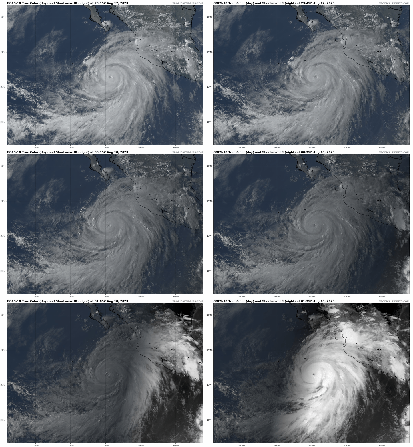
The sun sets on a rapidly intensifying Hurricane Hilary, south of Baja. (Tropical Tidbits)
Additional strengthening is likely, and Hilary is expected to become a category 4 storm by tomorrow. Hilary has been able to tap into an exceptionally favorable environment for rapid intensification, and that will allow the storm to peak at a high end. Warm water and low shear will do that.
Hilary’s trek toward Baja
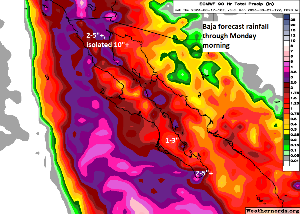
Tropical storm watches and warnings are posted for Baja, including Cabo with tropical storm conditions beginning at Cabo tomorrow night. If you know anyone visiting Cabo (or any southern Baja locations), my guess is that they are well prepared to handle a tropical storm type impact. Models are in high confidence that Hilary will pass safely offshore to keep impacts moderate there. The main threat may be heavy rain that causes flash flooding, as well as very rough surf at the coast.
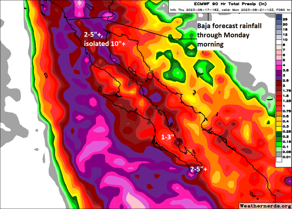
Rain totals will vary across Baja, but in general, the heaviest rain is expected in the north, as well as near Cabo, with flash flooding possible. (Weathernerds.org)
Hilary will begin to weaken as it encounters cooler waters off Baja, and it is expected to make landfall in the north or just scrape the northern coast of Baja before coming ashore in California. Hurricane force winds are possible in northern Baja but they may come up just short.
Hilary will come close to making landfall along the northern coast of Baja, though it may just scrape the coast and come ashore in California. Either way, the impacts will be (mostly) similar. (NOAA NHC)
That being said, interests along the Baja Peninsula should continue to monitor Hilary’s progress as it comes north.
The main event: Rain and flooding in the desert
For those of you living in the Desert Southwest, particularly interior California, you hear “hurricane” and you may think wind. Yes, winds may be part of the issue, particularly along eastern facing slopes of the mountains in SoCal. But take it from someone who lives in Houston and helped get people through Hurricane Harvey: Heed the warnings about rainfall.
The current rainfall forecast for the Southwest shows anywhere from 2 to 6″ over a broad area, with locally higher amounts, perhaps up to 10″ or even more in parts of California and Nevada.
The desert is in for an absolute soaking. While there will be heavy rain and flooding concerns in the coastal cities between San Diego and Ventura pending the exact final track of Hilary, the primary risk of severe flooding is in the mountains and deserts inland from the coast. (NOAA)
How much rain is this? Death Valley averages a bit over 2″ of rain a year, and they’re currently forecast to receive anywhere from 2 to 5 inches with Hilary. You can do the math. Rain like this comes down harder than usual and can quickly lead to flash flooding, arroyo flooding, and potentially longer-term issues in some spots from too much rain.
Put simply: This has the potential, if not the likelihood of being one of the most significant rain events in recent years in the deserts of southeast California and southern Nevada. For folks in Phoenix, this probably is not your storm. But for folks in Vegas and over the passes from LA and San Diego, this has potential to cause significant and severe disruption Sunday and Monday into early next week.
In addition to the rain, there will be significant marine issues along the coast from swells and rough seas. Tropical storm force winds are possible down to lower elevations in spots and along the coast, and stronger winds are likely in the mountains. We’ll get a better read on specifics of that once Hilary’s final track comes into view.
Anyone with interests in SoCal, Nevada, along the Colorado River in western Arizona and even north into parts of Idaho and Montana will want to be ready for Hilary’s arrival and plan to deal with some disruptions, if not significant ones Sunday and Monday. Folks just west of these locations, into the Central Valley and Central Coast of California and the Sierra will want to monitor forecast progress as well. A shift west could change impacts from Tahoe down through Santa Barbara.
All in all, this is looking like a high impact storm. We’ll keep you posted.
This post was written by Alison Green and published on Ask a Manager.
It’s four answers to four questions. Here we go…
1. My employer confiscated my favorite shirt
I work with disabled clients, and the other day one of them took a spill down the ramp and was bleeding. When I turned her onto her side, I took my button-down off to put under her head to keep it elevated and keep her from swallowing too much blood. Unfortunately, after she was taken to the hospital by EMTs, I put my shirt into a plastic bag to inspect/wash later. There was no visible blood on it, but I was of course going to wash it. I mentioned to a coworker that I was going to put my shirt in my car. My manager overheard and told me to give her the bag, and said she didn’t think she could give it back to me because there was probably a policy about it because of the blood. I pointed out that I wasn’t even sure if there was blood on it and that I was going to wash it, but I reluctantly handed it over, thinking it surely would be back with me in a matter of minutes but she didn’t give it back at the end of the day.
This is my favorite shirt. It has a lot of sentimental meaning to me and I made it clear that I loved it and would rather have the shirt than any potential reimbursement. I tried to joke and be a good sport while I was trying to get across that I love that shirt, but they didn’t seem to care. I feel so betrayed. Are they really allowed to just take my shirt? If it were any other job, I would be seriously considering quitting but I can’t afford to leave. I’m at a complete loss as to what to do.
Talk to your boss! It sounds like your organization might have a policy about disposing of materials that have come into contact with body fluids, but it doesn’t sound like your boss is even sure about that. Talk to her and don’t joke about it this time — that’s just opening the door to her misunderstanding what you’re trying to convey and how strongly you feel about it. Say something like, “That shirt has deep sentimental value to me, and it’s extremely important to me to get it back. If it were a different shirt, I wouldn’t be pushing this, but I don’t think I should lose an item that’s so important to me that didn’t even seem to have blood on it. What do I need to do to get it returned to me?” And assuming you didn’t sign something to the contrary, you could add, “I didn’t consent to have a personal possession taken from me and I do need it returned.” If she’s unsure of the policy or who should deal with this, ask her who would know and talk to that person.
I do think you need to prepare for the possibility that they may have already gotten rid of it. (I’m sorry!) But this will give you the best shot at recovering it.
2. Whose job is it to address burn-out?
I noticed recently that I’m experiencing the symptoms of burn -out. There are many different lists and articles out there but the first one Google gave me resonated a lot — especially the lists of symptoms and potential causes (most are applicable).
I raised this with my manager, including a few of what I thought the likely causes were, relevant to our department and my work. I intended it as feedback, to trigger for them some reflection of how he might reorganize our work, create improved processes, and generally try to support me. These are all issues that have been raised before, but which I don’t have much power to directly change.
Their response instead was to pitch it back to me, saying, “Let me know what you’re doing to address it, and let me know what specifically you need from me.” The tone was supportive, but seems to put all the work of figuring out how to address my burn-out on me. But I’m burned out! I don’t care enough to figure it out!
So generally speaking, when it comes to addressing employee burn-out, who has the primary responsibility? Employee, or manager?
In theory or in reality? In reality it’s nearly always the employee.
The response you got from your manager is about the response I’d expect. It’s pretty rare for a single employee’s concerns about burn-out to trigger much more than that, and especially not substantial changes to processes. Typically it takes multiple people raising the same concerns, and even then that’s often not enough and nothing happens until they lose multiple employees over it (and often not even then). Occasionally a single person might be able to get it done, if (a) they’re especially valued and the employer is deeply invested in not losing them and (b) the manager is skilled, reasonable, and has enough capital themselves to make the sorts of real changes that would help.
The response you got is about what you can realistically hope for — an invitation to come back with specific requests for changes that would help you.
For the record, that’s not always unreasonable. It can make sense to put the ball in your court to propose what you need, especially if no one else on the team is struggling (or known to be struggling, at least). That’s particularly true if your manager knows the workload itself isn’t likely to change, but that she might be able to make some adjustments if you tell her what you want. Yes, in an ideal world she’d suggest some options since you might not even know what’s on the table — but it’s not unfair for her to ask you to talk in specifics about what you need.
3. Paying for employees’ significant others to join them on business trips
Is it normal for employees’ significant others to be accommodated on business trips?
At a previous job, my manager complained to me that our boss didn’t want to pay for flight and hotel accommodations so she could bring her fiance on a business trip we were all attending, when he had paid for her now ex-husband on a past trip. At the time, I didn’t comment but did think it was odd that he’d done so in the first place. However, I was young and after leaving that job moved into a field where trips aren’t the norm, so haven’t had reason to encounter a situation like this since. Is it common for employees’ significant others, who do not have jobs in the company, to be accommodated on business trips?
Nope! Sometimes someone will bring a partner along (so they can hang out at night and the partner can sightsee in the area during the day or so forth), but generally the employee pays the partner’s expenses; the employer wouldn’t cover the additional expense.
In very rare situations, there might be a business reason for doing paying a partner’s expenses (for example, if the employee is breast-feeding and only agrees to travel if the baby can come, with the spouse to take care of the baby while they work) but it would be very much the exception to the rule.
4. Acknowledgement of a condolence gift
A coworker died last month. I did not attend the funeral service but sent a nice gift with a personal note to the family. Should I expect a thank-you from the family? I would at least like to know if they received the gift.
Assume they almost certainly got it, but since they’re grieving they might not be a state to deal with thank-you notes (but no doubt appreciated the thought).
The Marion County Recordnow has all of the devices police seized in a raid. Local newspapers report that the judge who signed the search warrant had two drunken driving arrests within a year.
From the Houston Museum of African American Culture:
“The Houston Museum of African American Culture (HMAAC) is excited to present El Franco Lee II: Mid-Career Survey, curated by HMAAC’s Chief Curator Christopher Blay. This exhibition is the first solo museum exhibition of the Houston-based artist El Franco Lee II’s work. This retrospective survey is a collection of 30 works created over the past 16 years of the artist’s professional career which developed from early childhood drawings through his formal training at Yale University, a BFA in painting, and later an MFA, both from the School of Art at the University of Houston.
El Franco aptly refers to his style as Urban Mannerist Pop Art as the bizarre and grotesque come together in his paintings in ways that feel illogical, but perfectly balanced. His compressed and flattened figures form grand tableaux, fueling, as Outkast puts it, ‘the art of storytelling.’ In his paintings, El Franco bobs and weaves his way from historical figures such as the boxer Jack Johnson, through other Black icons such as Michael Jackson, Jordan, Tupac, and JR Richards. But it is his masterful chronology of Houston Hip Hop lore, specifically his depictions of the late Houston Rapper DJ Screw and his Screwed Up Click (SUC) that Lee is most known for.”
“Repurpose by Colby Deal is the inward practice and outward act of repurposing materials and experiences that carry personal resonance. This collection is a mirror to his own life’s journey of self-reconstruction and preservation through the collaging of consciously safeguarded materials and images, seeing in them not only their inherent value but also his own life’s potential for rebirth.”
Kyle Steed, “Pulling the Weeds Out,” acrylic on canvas, 70 x 50 inches.
“Pure Land might best be viewed as the very embodiment of my presence, my essence. An offering of thanks to every teacher whose help has guided me through thin veils and thickest of thieves. To be alive can be all I need. The title is adapted from the pages of one of my favorite books, You Are Here, by Thich Nhat Hahn. Embedded in this new body of work, Pure Land, is an ode to self-energy. Something a psychic once told me I would be moving into. The themes of acceptance, integration, death and birth are allowed to be explored and left to us, you and me (the collective we), to continue searching for.*hint: we never fully arrive. The groundless nature of these works are meant to harmonize with an inward space. An inward calling. Where I view the world hanging in spatial balance. I arrange my work/my life in a very intentional manner of chaos.”
From Texarkana Regional Arts and Humanities Council:
“Friday, July 7, marks the opening of TRAHC’s 35th Annual Juried Exhibition. With 70 pieces of art from regional, national, and international artists, this year’s show is filled with incredible, and engaging work. A wide range of mediums including, painting, video, drawing, augmented reality, sculpture, ceramics, printmaking, and photography will be on display.
‘From the beginning, it was clear to me the importance of this exhibition to many in the region. As I combed through the over three hundred submissions, I saw artists working in a range of style and content across a variety of media. I appreciated seeing the technical skill as well as a bit of play in the submissions. It proved to me that there are still surprises to be found in art despite the constant stream of visual stimulation we encounter everyday,’ writes Iris Bechtol, Adult Juried Exhibition Juror 2023 in her statement.”
Raul Rene Gonzalez’s work at Wanderlust Ironworks Gallery.
“Wanderlust Ironworks Gallery presents Then And Now, a solo exhibition featuring Raul Rene Gonzalez. For the exhibition, Gonzalez will share a new series of drawings and paintings on concrete alongside a collection of mixed-media, abstract paintings created over the past 10+ years.”
This post was written by Alison Green and published on Ask a Manager.
Let’s talk about terrible conference food — or hell, we can broaden to terrible work event food in general.
Some stories readers have shared in the past about culinary failures:
I have attended several conferences that were bad, but nothing beats the time the group was served chicken on a bed of lettuce. The vegetarian option was just the lettuce. One singular lettuce leaf. The vegetarians assumed they just forgot another protein, like tofu, but no, that was the entire entree.
I went to a conference and had specifically told them I was vegan (this was about ten years ago, when that was pretty unusual). For lunch on the first day, I was presented with a bowl of undressed salad leaves and a single cherry tomato.
Worst conference food I ever had to deal with was the conference that didn’t think about the need to accommodate those that can’t eat seafood. Three day conference, lunch and dinner provided and every single meal was shellfish of some variety. No vegetarian options, no shellfish free options (though with the quantities of shellfish they were prepping I wouldn’t have trusted the kitchen anyways) – just scallops, crab, shrimp, crawfish, lobster as far as the eye could see. I had to leave for every single meal because of a lack of food.
The first day, the afternoon snack was hot items you needed a fork to eat … so everyone figured the next day’s “afternoon snack” (as it was listed on the agenda) would be similar. Nope! The next day’s snack was coffee and tea. No food, and no indication that it would be different. Then the lunch items were kind of all over the place, with the veggie options being the worst – like a limp lettuce sandwich as the only veg option, while everything else was hot plates. They were also frequently running out of food, and people had to go into the city to eat.
Let’s hear your stories of bad conference food/bad work event food.
This post was written by Alison Green and published on Ask a Manager.
A reader writes:
I work as a college instructor. I got an email request for a meeting with the president of our college for this coming Tuesday.
I called to confirm the meeting with his secretary and also to ask how I could prepare for the meeting. Her response was he just wants to have a conversation.
The meeting request was just sent to me by his secretary and all my interactions with my supervisor and our vice president have been positive up to this point.
Should I be concerned I’m getting reprimanded or terminated?
It’s highly unlikely that the college president wants to meet with you to reprimand you or fire you; those are things that would normally come from your manager (or with a firing, sometimes HR). Someone multiple levels up from you isn’t normally going to be the one handling those things, unless you messed up in a truly spectacular way (meaning a media attention/lawsuits/ruined careers sort of way, and you’d probably know if that had happened).
Things this meeting could be about:
– he’s meeting with a smattering of people across the organization to get input/take temperatures/do a general meet-and-greet (this is the most likely, if I were putting money on it)
– he just found out he was childhood best friends with your aunt and wants to meet you
– your family is extremely rich and he wants you to hit them up for money
– he wants your input on something involving your boss (this one is unlikely given his position, but if he weren’t the president and was instead a few levels down, it could be possible)
– you’re winning an award
– his DNA test revealed you have the same dad (probably not)
– all sorts of other, non-horrible things we can’t predict
Think about all of the times you needed to meet with some at work about something mundane and routine. It’s highly, highly likely that this will be in that category.
To make this more broadly applicable, all of the above would also be true even if this weren’t a college president. If this were just your boss’s boss or one more level up, I’d still be telling you the same thing. The only change I’d make would be to add even more non-scary possibilities to the list, often logistical things related to work projects.
People have a tendency to freak out when someone above them wants to meet and they don’t know the topic … but the vast, vast majority of the time it’s for something very mundane.
Your opinions on the discography of the last fifty years interests me about as much as you think it does a middle-aged woman traveling coach to Boston with a L.L. Bean boat tote filled with crackers. I read mild. I read invisible. I read that probably all I listen to is “Ripple” by the Grateful Dead.
It’s easy to assume that I don’t know who Fugazi is. It’s okay, insult me—you can barely grow beards.
Here’s the thing, though: I know who Fugazi is. And you will never grow beards because of the xenoestrogens in your plastic water bottles. Don’t be fooled by my comfortable and supportive footwear, my tie-dye rainbow Crocs; I know a lot about music.
So it was insufferable for me to endure you two loudly opining in the Northeast Regional quiet car on the Velvet Underground’s 1970s New York scene. On DC punk in the 1980s. On trip-hop and Aphex Twin and post-punk and De La Soul and hip-hop and the country revival and New Orleans bounce and Ye and on which bands sucked Nirvana’s teat derivatively. Oh, you went on and on. I felt like I was trapped in one of those podcasts where know-it-all bros one-up each other. But I kept my mouth shut.
However, when you struggled to name the Red Hot Chili Peppers bassist, I thought, It’s Flea, you total asshats.
Then, as we were pulling out of Newark, one of you shrieked, “High key, dog, why are the Pixies on this Pitchfork ‘Best Albums of All Time’ list? They’re ass. Dog, they’re 100 percent derivative of Nirvana.” All my Gen-X senses started to tingle.
You belittle the Pixies? You diss Black Francis? On the way to Massachusetts? On my gal, the bassist Kim Deal, you didn’t have a crush at Smith College in 1992? Were you not even born?
I leaned over my Amtrak headrest and hissed, “Boyx, that’s cap. You’ve been talking out of your asses since Union Station.”
I continued, “In ‘Five Classic Albums That Wouldn’t Exist Without Pixies’ Surfer Rosa,’ Jochan Embley wrote, ‘Grunge owes so much to Nirvana, but Nirvana owe a great deal to Pixies.’ Kurt Cobain publicly said he was trying to rip off a Pixies song when he wrote ‘Smells Like Teen Spirit.’ Nirvana was trying to sound like Pixies, you morons—Death to the Pixies.”
I went on: “Disc one of Death to the Pixies is the random-button scrambling of the Pixies’ studio discs; disc two is a convincing live show that repeats a few of the songs and still doesn’t make you feel that you’ve heard too much. There are, of course, plenty of arguments to be made for the band’s original sequencing, but since the Pixies are as adept at pop hooks as they are at punk screech, the set works to freshen songs you know well—an effective reintroduction to a group that perhaps sounds even greater now than it did when making an LP a year in the late ’80s and early ’90s. Gigantic indeed.”
You looked at me. My hair askew. My eyes blazing behind my +1.25 rainbow readers that, yep, match my Crocs. My seltzer sloshing in my hand. I hoped you were thinking, Holy shit, dog. We’re meeting a real-life strega for the Pixies. Stregas for the Pixies are the rarest, most righteous, ass-kicking, music-knowing motherfuckering fairies from planet ’90s. Josh, I wonder how she’s going to bless us? I don’t know, Jeraboam, but I am sure she will… somehow.
Instead, you said, “Jesus Christ, lady. All right already.” You turned away from me. I heard you mutter, “Damn, dog, that’s one furious grandma.” You put on large puffy headphones and were silent all the way to Providence. There, you disembarked.
I’m sorry. If you had been nice—if you had been like, “Wow, strega, you know things! We judged you incorrectly as boringly into ‘Ripple’ like every other oldster, but we were wrong, you’re an arrogant, loud, obnoxious music knower—you’re one of us,” I would have shared my water crackers with you and intricately detailed the post-Pixies solo careers of Frank Black and twin sisters Kim and Kelley Deal.
After you left, a nice lady about my age boarded and asked if your seats were taken. I said, “Only if you have a favorite Pixies song and can defend your reasoning at a volume appropriate to the Amtrak quiet car.” She pulled her readers off the top of her head where they were nestled in the gray bun of her hair and let them hang around her neck on their rainbow-beaded lanyard. She sized me up and said, “‘Gigantic.’”
See, sirs, it’s not so hard to get along with me.
If you do land a podcast—and I sincerely hope you do, because I’m not sure you are good for anything else and I actually, grudgingly, liked your take on Iron Maiden—please consider me. I bring something unexpected to your podcast: the entire audience of Gen-X women in menopause.
Here’s to Blood on the Tracks, boys, the best Dylan album, and don’t argue with me.
— Liz
- - -
Read an interview with author Elizabeth Bastos about writing this letter over on our Patreon page.
EUGENE, OR—Warning the 32-year-old man that you couldn’t trust anyone nowadays, local mom Sandy Fremont reportedly begged her adult son on Thursday to “be careful” while going to use a restaurant bathroom. “Please, son, I know you’re responsible, but I’ve read some stories about restrooms that would scare the bejeezus…
Atlantic action stays out at sea, a Gulf system remains a possibility next week, and <checks notes> California will be impacted by Hurricane Hilary.
Happening now: Still waiting
We’re not ones to tempt fate here at The Eyewall. We legitimately want everyone to have a peaceful hurricane season with minimal stress and anxiety. So, while we are still waiting for something to come of the “noise” in the tropics this week, we’re not complaining either.
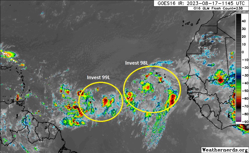
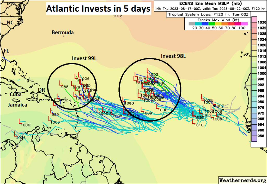
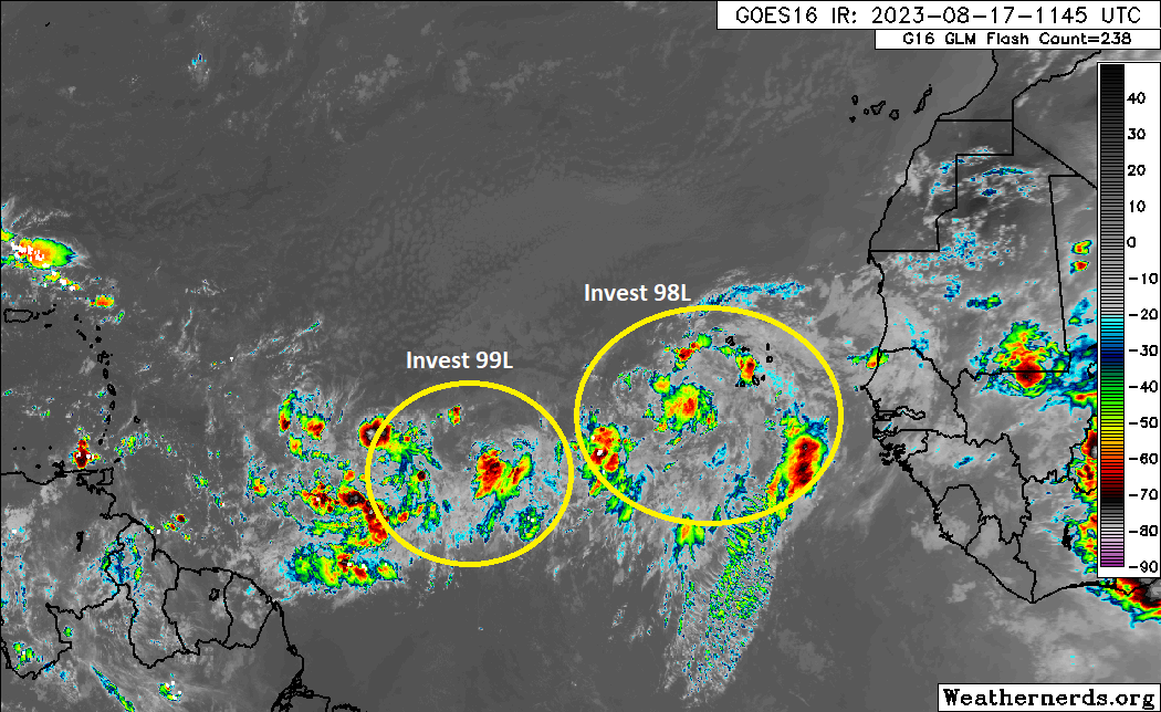
Two waves in the Atlantic have a 60 percent chance each to develop in the coming days. They have been dubbed Invest 98L (east) and Invest 99L (west). Both are expected to remain out at sea, thankfully, but you can see them on satellite this morning.
The two Atlantic tropical waves on satellite this morning don’t look especially close to organizing yet, but they’re getting there. Both are expected to remain out at sea. (Weathernerds.org)
Earlier this week, I said the trailing wave might have a better shot to do something. As of today, I think it’s really a toss-up. Either invest could be “the one,” but neither looks exactly superb as of yet. We still anticipate that the upper level pattern will safely steer both disturbances out to sea.
Both invests are expected to remain out at sea per most model guidance (the Euro ensemble members shown here), but even if it weren’t to turn out to sea entirely, any development is expected to be slow and lower end. (Weathernerds.org)
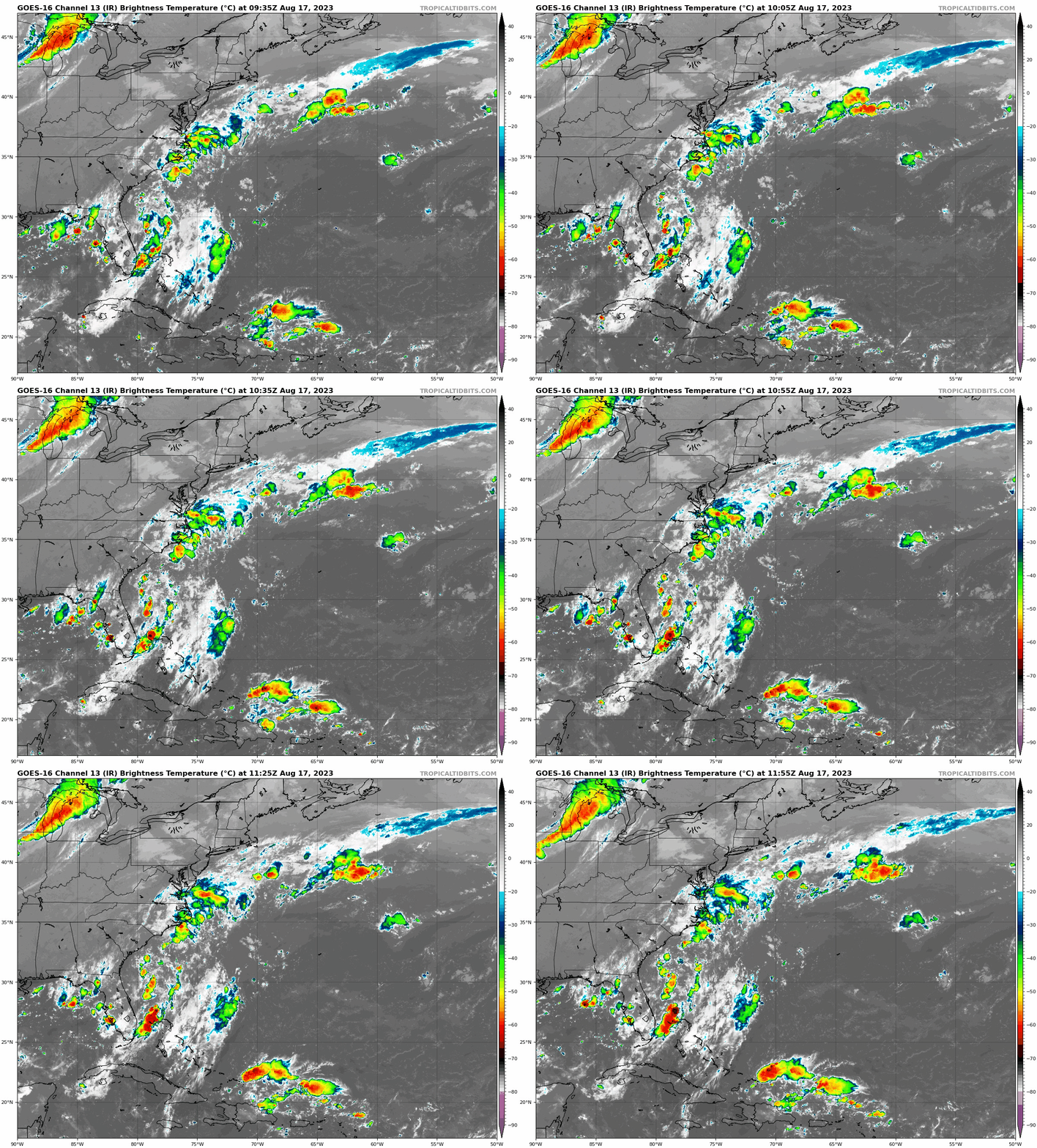
Interests in the Lesser Antilles should make sure this doesn’t change, so keep an eye on things the next couple days just to be safe. Meanwhile, let’s look closer at the northern Caribbean and southwest Atlantic this morning, where the ingredients for our more meaningful Gulf disturbance will slowly come together over the next few days.
Unsettled weather off the coast of Florida and north of Hispaniola should come together in the eastern Gulf this weekend to provide a slight chance for tropical development. (Tropical Tidbits)
The primary impetus for this disturbance is currently just north of Hispaniola. This will race off to the west-northwest and merge with some additional activity in the eastern Gulf and we’ll have our disturbance. The NHC gives it a 30 percent chance of developing next week. The general spirit of things: “A disturbance with a low ceiling potential for development will race west across the Gulf next week toward Texas” seems to remain the story here. A good idea to keep tabs on this one, but there’s a very good chance this will not cause any significant problems.
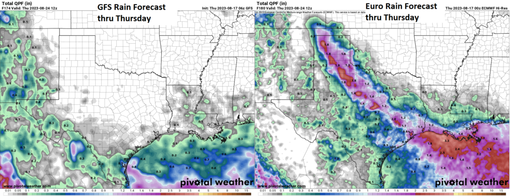
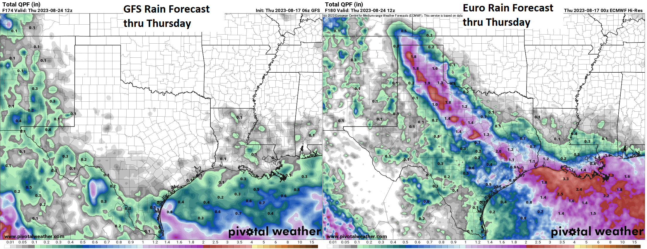
What of the rain? The hope was (and still is) that this disturbance can drag enough Gulf moisture into drought-plagued Texas and/or Louisiana to help deliver some rainfall and provide some relief from drought. If you look at the forecast rain totals next week from the deterministic and operational GFS (left) and Euro (right), you can see some substantial differences. The GFS suppresses diffuse rain to the south, while the Euro is like “Heck yeah, brother!”
Click to enlarge forecast maps of the GFS & European model rainfall through next Thursday. (Pivotal Weather)
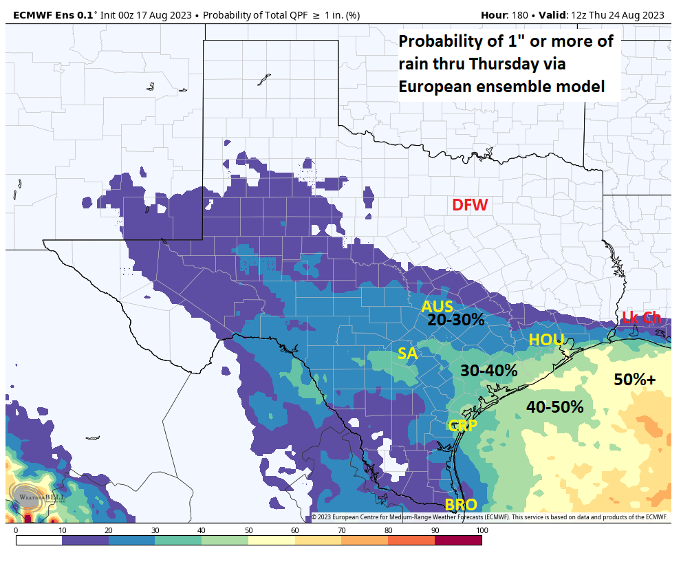
Well, let’s look specifically at the Euro. If you unpack the Euro ensemble, which is an average of 50 different European model runs with different tweaks at initialization, the picture that’s painted is a bit different than that of the operational model shown above. The map below shows the European ensemble probability of 1″ or more of rain. Not high!
Probabilities of 1″ or more of rain next week are highest offshore and south of I-10 in Texas, meaning any serious drought relief inland seems unlikely from this disturbance. (Weather Bell)
Ensembles help us a lot in these situations because they can validate or invalidate critical deterministic guidance. In this case, it puts an awful lot of doubt on that European operational model that brings 1 to 4 inches of rain to Texas and southwest Louisiana. It has the placement farther south and west and probably with lower odds.
Bottom line: While some rain is likely in drought-stricken Texas, this may not be the droid you’re looking for.
Interlude: Californication
Our site is intended to primarily cover Atlantic tropics, but every so often, something interesting and worth discussing happens on the Pacific side too. Today we focus on California.
Rare as it is, California can get impacted by tropical storms, although it takes a heck of a lot of things to come together to get that to happen. The last time this officially happened was in 1939 when a tropical storm made landfall near San Pedro (between the Port of Long Beach and Rancho Palos Verdes). As recently as last year, Hurricane Kay brought remnant impacts to California that were rather significant. Suffice to say though, it’s unusual. Hurricane Hilary just formed in the Pacific, and the official forecast track will raise an eyebrow or two.
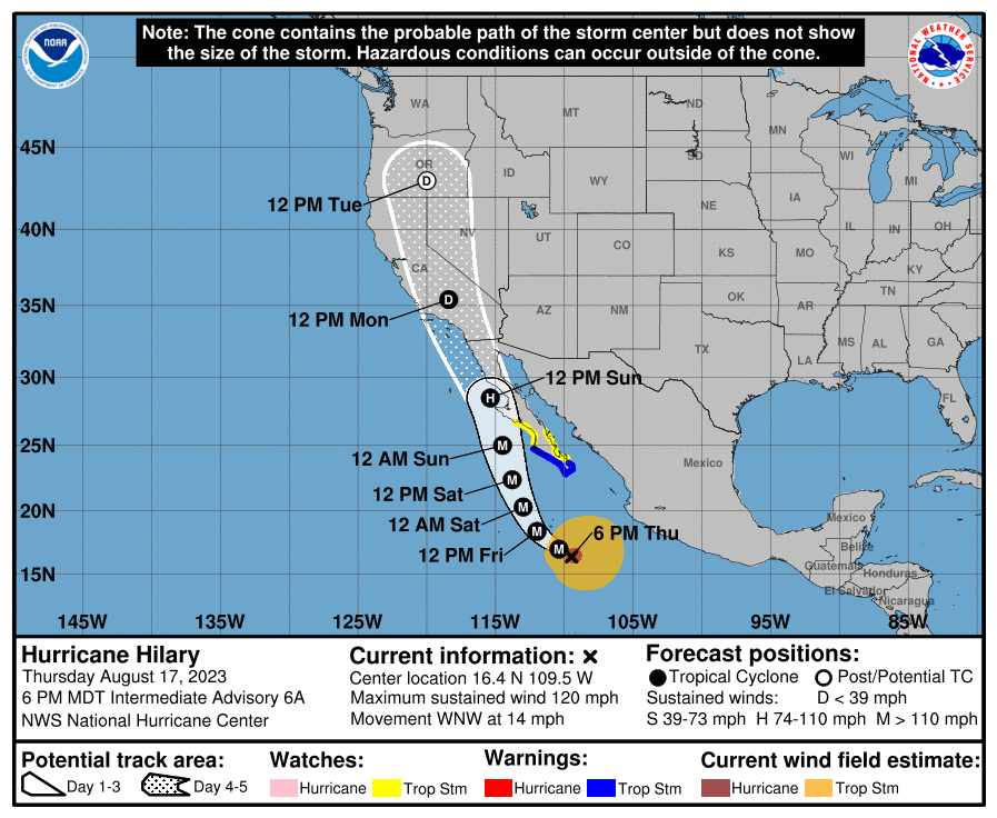
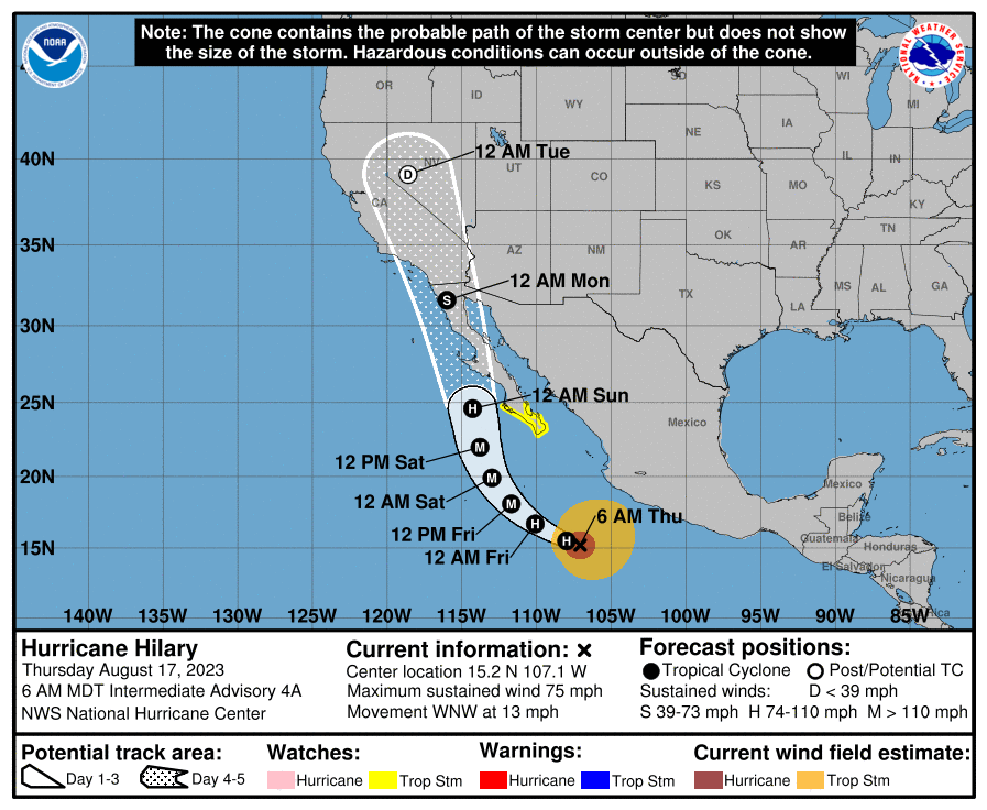
Hilary has exploded into a category 1 hurricane and should become a major hurricane before weakening as it approaches Baja or Southern California late this weekend and Monday. (NOAA NHC)
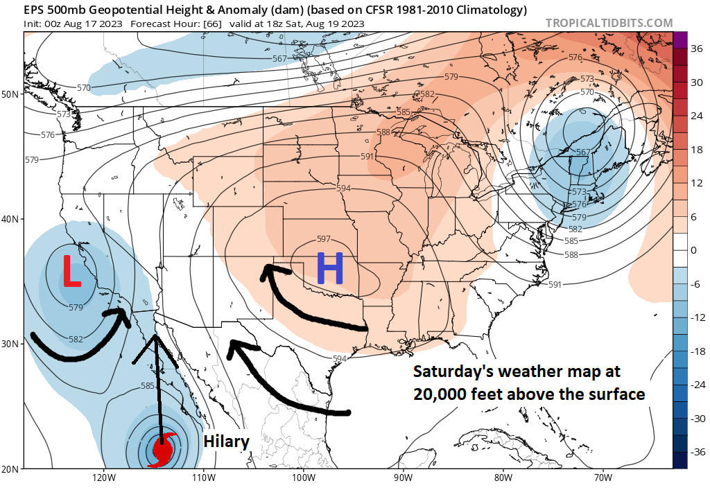
This has support from modeling. As Hilary comes north, it will be steered by a trough to its north and the insanely sprawling, near-record ridge over the Midwest and Plains. Hilary should come north, roughly parallel to Baja but offshore initially. It will then likely get drawn inland somewhere between Point Conception (west of Santa Barbara) and the central coast of Baja in Mexico. The most likely outcome right now is a Baja landfall north of Cabo and San Carlos. Anyone in Cabo, tropical storm conditions are possible, but hurricane conditions are currently expected to stay offshore.
Hilary will be drawn north in the alley between the so-called “heat dome” over the Plains and an upper low off the Central Coast of California. Exactly where that sets up will determine where Hilary tracks, but model agreement strongly points to a Baja landfall right now (Tropical Tidbits)
Since yesterday, modeling seems to have coalesced around another storm not making official landfall in California, and as shown by the NHC above, it will probably make land in Baja. However, the general theme of things, bringing Hilary north will bring the remnant moisture northward too.
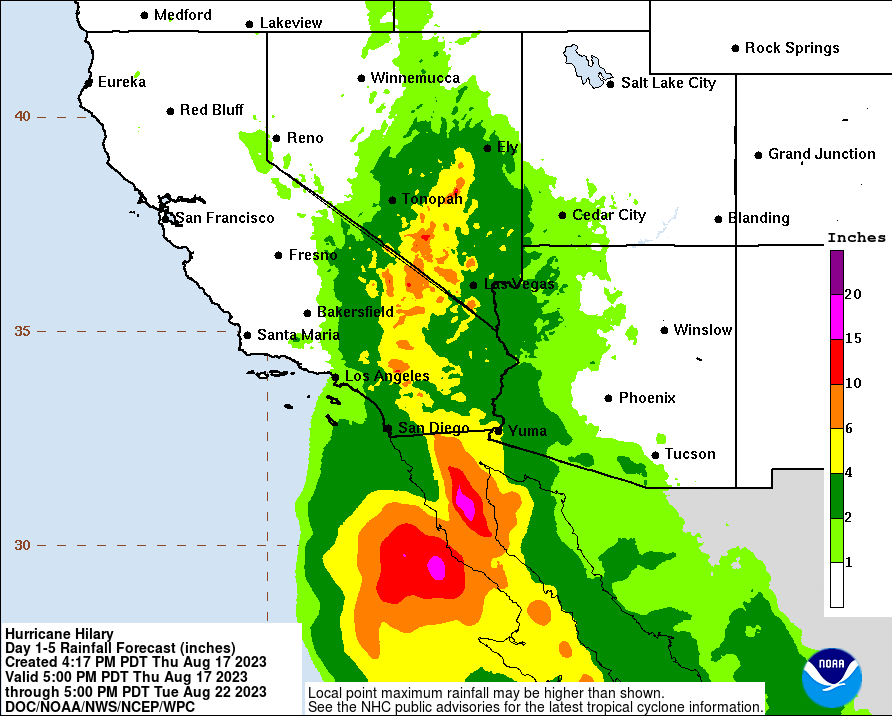
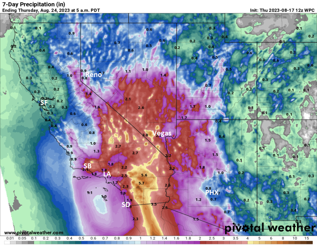
In general, you should expect a good chance of heavy rain in SoCal, especially in the desert and up into Nevada and for portions of western Arizona and southwest Utah beginning Sunday into Monday, but specifics will be tough to nail down. Additionally, strong winds in passes and at higher elevations will be an issue.
Heavy rain from Hilary will potentially cause significant flooding issues in interior southern California and western Arizona up through Nevada. (Pivotal Weather)
That type of rain (3 to 6 inches) in the desert can cause severe flooding issues, so folks between Phoenix and San Diego northward (as well as on Baja obviously) should be monitoring Hilary’s progress. Check out your local National Weather Service office for more localized details.
The medium range (days 6 to 10): A bit of an interlude period
I think the medium range period right now looks like a quieter one with the potential of lingering open Atlantic activity and then a bridge to extended period development in the Gulf, Caribbean, or southwest Atlantic. There are no specific concerns at this time beyond Hilary in California and babysitting the Gulf wave next week.
Fantasyland (beyond day 10): More to come
The system (meaning the atmosphere) remains cranky and noisy beyond day 10 I think. There are several things that might happen, but there is nothing we necessarily feel convicted about that will happen.
For one, as both Eric and I have alluded to in recent days, we could see a gyre setup over Central America, which could spice things up a bit, especially in the Caribbean or eastern Gulf. Some modeling is suggesting that stuff could creep north toward the Bahamas or off the Southeast U.S. coast. The eastern Atlantic may settle down a bit here.
What will ultimately dictate things in the extended range will be the upper pattern. Do we have another ridge over Texas? Will it have nudged back to the Southwest? Will the Bermuda high remain mostly at bay in the Atlantic, keeping the exit door open north and northeast? A lot of things to answer here. We can only speak in broad, vague terms right now. Our advice: Stay tuned.

 Due to the tropical storm tonight's EIT! KIDZ KLUB show in LA is POSTPONED. A new date will be announced shortly. Sorry for the inconvenience!