News in Photos
The post Olympic trampolinist scores extra points for resonant, high pitched “wheee!!!” appeared first on The Beaverton.
News in Photos
The post Olympic trampolinist scores extra points for resonant, high pitched “wheee!!!” appeared first on The Beaverton.
News in Photos
The post Lucky boy in Olympic audience catches shot put appeared first on The Beaverton.

The post Turn That Frown appeared first on The Perry Bible Fellowship.

Russia, the United States, and several other countries engaged in an extraordinary 24-prisoner exchange, the largest of its kind since the Cold War and one in which President Joe Biden was directly involved. What do you think?
In brief: Houston will face some of its hottest weather today and Saturday before a weak front makes its last gasp over the area. We cannot rule out a few thunderstorms on Saturday evening, and then some showers on Sunday, but for the most part our weather this weekend and next week is going to be hot and sunny.
High pressure will be dominant today and for much of Saturday, leading to some of our hottest conditions so far this summer. Friday, therefore, will likely a little bit warmer than we’ve experienced that last couple of days even. Most of the Houston region, away from the coast, is likely to see highs pushing into the upper-90s. Winds will be light, from the south at only 5 mph. With dewpoints in the mid- to upper-70s, the air will feel sticky. Low temperatures tonight will only fall to around 80 degrees for much of the city. So yeah, this will be full-on summer in Houston.
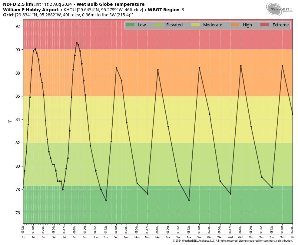
The first half of the weekend is likely to be even a touch warmer than Friday. This will be due, in part, to the advancement of a weak front that will eventually fizzle out over the Houston area. What happens as a front advances is that, typically, it compresses the air ahead of it downstream. The front is fairly weak, but this compressional heating could be enough to add a couple of degrees on Saturday. Therefore I expect most of the region to reach the upper 90s, with a few locations possibly hitting 100 degrees. Skies will be sunny during the daytime. I do think it’s possible that we see some isolated or scattered showers on Saturday evening, with the possibility of thunderstorms. So while these aren’t probable, they are possible.
The front should bring a few degrees off the top end of our temperatures, so highs on Sunday will likely drop back into the mid- to upper-90s. There is also a decent chance of showers on Sunday and Sunday evening. By decent I mean maybe 30 percent for areas along and south of Interstate 10, and 20 percent further inland. Mostly, however, our skies will be sunny and the air plenty humid still—sorry, it’s a very weak front that will fall apart as it pushes into the region. Lows on Sunday night will drop into the upper 70s.
Most of next week looks sunny and hot, with high temperatures in the mid- to upper-90s. There will be a smattering of rain chances, but they’re low overall, perhaps 10 to 20 percent daily. Mostly, it’s just going to feel like Houston in August. For most of us, that’s pretty miserable. But aside from the heat we should have no worries about storms or the like, which is nice after what Houston has experienced so far this spring and summer.
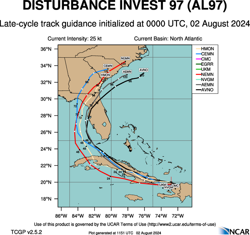
The forecast for the tropical disturbance AL97 is coming into better focus, and it looks to be a rainmaker for Florida and potentially the US East Coast this weekend and into early next week. As we’ve been saying for a few days, there is zero threat to Texas from this system. We’ll continue to track the storm in depth today, and this weekend, on The Eyewall.

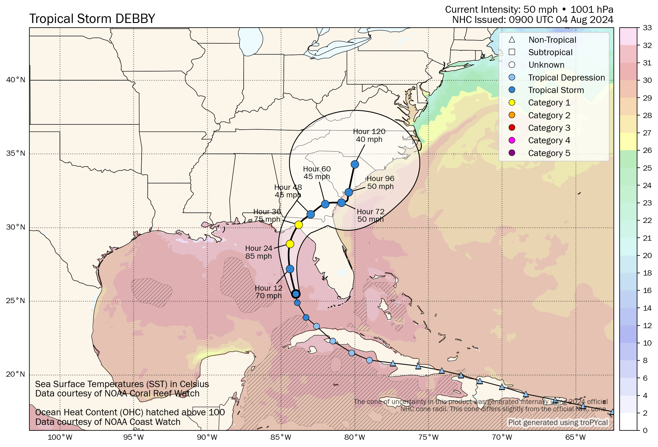
Tropical Storm Debby continues to gradually organize off the west coast of Florida this morning, now a more formidable tropical storm.
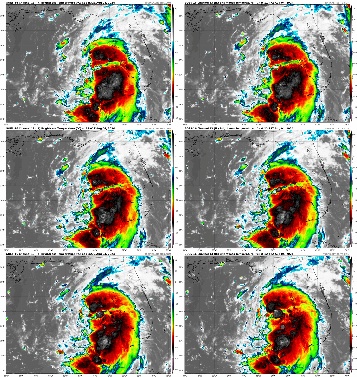
The bad news is that Debby continues to organize, but I suppose the good news is that it does continue to have some inhibiting factors, chief among it, dry air on the west side of the storm. This will likely be a subtle player in keeping Debby from totally maxing out its intensity potential. That said, Debby is still expected to make landfall in Florida near or just west of the Big Bend as a strengthening category 1 hurricane (similar in some ways to Beryl in Texas last month). This is important for much of that area, and specifically for the Tallahassee metro area in terms of potential widespread power outages. Debby’s exact track will help determine that.
Debby’s storm surge
Starting first with surge, the expectation is that 6 to 10 feet of water could come in along the coast of the Big Bend with Debby’s current track.
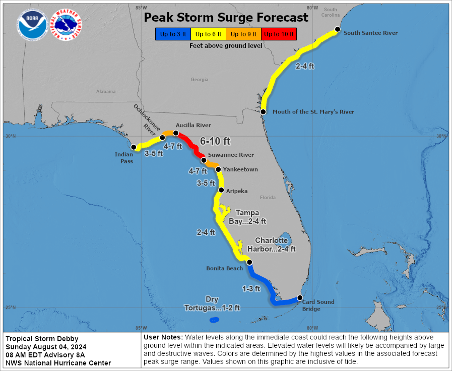
These values are less than were forecast during Hurricane Idalia last summer, but still extremely dangerous. Again, keep in mind that Debby is likely to be strengthening on approach whereas Idalia was weakening on approach. There may be more similarities between the two storms than expected and just because this one is “only” a category 1 storm should not factor into your preparations. Conditions will deteriorate today, so please heed the advice of local officials.
Debby’s track and wind
Debby is expected to come ashore just west of the Big Bend as a strengthening Cat 1 storm. While I noted some dry air above helping to limit Debby’s maximum potential, the biggest limiting factor for Debby may be time. Debby should come ashore in Florida late tonight or early Monday morning, so it has about 18-24 hours left to do whatever it will do.
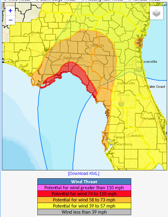
Squalls and bands from Debby will impact Florida’s west coast today, including Tampa with some gusty wind and heavy rain. The worst wind and rain will likely occur from Tallahassee eastward.
Beyond the Big Bend, Debby’s forecast track becomes extremely uncertain. In general, we expect Debby to slam on the brakes and drift northeast, then east-northeast, then, well your guess is as good as ours right now. There are questions as to whether Debby emerges off the East Coast, meanders around so erratically that it ends up back in the Gulf, or perhaps it even just drifts north into eventual oblivion. This leads us to our next issue.
Debby’s potentially historic flooding
Debby is a hurricane first and foremost, and we’re obviously concerned for Florida. That said, the most obvious threat from Debby continues to be flooding rainfall.
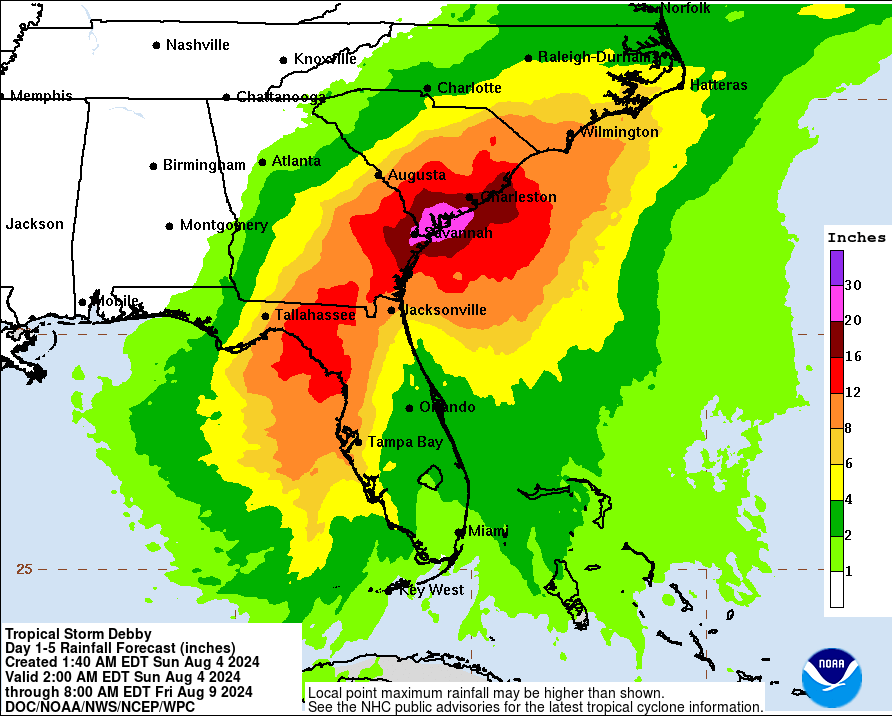
We are now entering some historic territory with Debby’s rainfall forecast. 20 to 30 inches of rain is now expected between Savannah and Charleston, SC, including Hilton Head. This will cause widespread, possibly catastrophic flash flooding, urban flooding, and river flooding in coastal Georgia and South Carolina. The worst will likely be south and east of I-95, but significant flooding concerns will also exist back toward Columbia, SC, Augusta, GA, possibly up toward Myrtle Beach and into southeastern North Carolina as well.
The standing record for rainfall from a tropical system in South Carolina is 23.63″ from Florence in 2018. Joaquin in 2015 aided in over 26″ as well, so we are currently forecasting that rain totals may approach these record levels. For Georgia, the standing record is almost 28″ during 1994’s Tropical Storm Alberto. Whether it’s a record or not, there are unique aspects to this event, including the potential for coastal flooding to exacerbate flooding conditions in places like Savannah, Charleston, Hilton Head, and Myrtle Beach.
I cannot emphasize enough how serious of a flooding threat this is for southeast Georgia and coastal and Lowcountry portions of South Carolina. Please ensure folks in these areas are prepared for this potential.
As always, isolated tornadoes are a possibility as Debby comes ashore.
So, in summary:
A quick note on the rest of the tropics this morning. We currently have two tropical waves worth watching. One is entering the Caribbean today, while the other sits just off Africa.
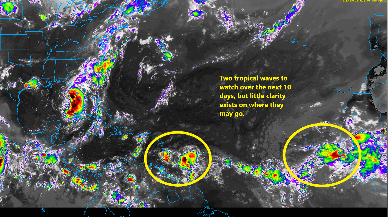
The National Hurricane Center has 20 percent odds for the Caribbean wave to develop as it meanders west. Some modeling does try to allow it to gain some latitude eventually, so I would say we should keep an eye on this one. Same with the one behind it that will be moving into an Atlantic that should be modestly more hospitable for tropical development. We’ll continue to watch. For now, no specific area should be worrying, but it’s now time to check in on the tropics every day or two from now through September or October.

Enlarge (credit: Tony C. French/Getty)
A small study in Texas suggests that human bird flu cases are being missed on dairy farms where the H5N1 virus has taken off in cows, sparking an unprecedented nationwide outbreak.
The finding adds some data to what many experts have suspected amid the outbreak. But the authors of the study, led by researchers at the University of Texas Medical Branch in Galveston, went further, stating bluntly why the US is failing to fully surveil, let alone contain, a virus with pandemic potential.
"Due to fears that research might damage dairy businesses, studies like this one have been few," the authors write in the topline summary of their study, which was posted online as a pre-print and had not been peer-reviewed.
PARIS – After Canada overcame their 6 point deduction during the group stage by going 3-0, Fifa officials have announced that the Canadian women’s soccer team will only be allowed to kick the ball with their left feet during their elimination match against Germany. “In light of new evidence coming to light that the Canadian […]
The post Embarrassed FIFA announces that Canadians can only use their left feet during quarter-finals appeared first on The Beaverton.
Iran’s Supreme Leader vowed to seek revenge against Israel for the killing of Hamas’ top political leader in a predawn airstrike in the Iranian capital of Tehran, risking escalating the conflict into an all-out regional war. What do you think?

CINCINNATI—Describing the deep shame but also freedom that came with finally saying it out loud, supermarket chain Kroger recalled over 2 million packs of lettuce Friday that the company had developed a psychosexual relationship with. “We apologize for the inconvenience to our loyal Kroger customers, but this morning,…
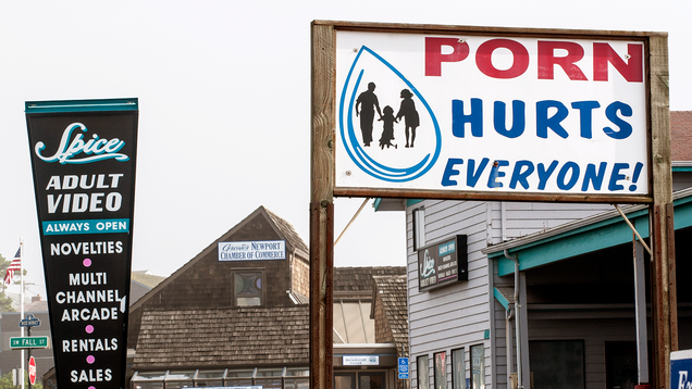
With Project 2025 calling for the criminalization of porn and age-verification laws already on the books in multiple states, The Onion examines the pros and cons of banning pornographic material.

Former President Trump claimed Vice President Kamala Harris “became [...] Black” during a panel at the National Association of Black Journalists’ annual convention, saying he didn’t know she was Black until “a number of years ago.” What do you think?

Hovertext:
Massive eternal regret for deciding evolution had elaborate speech bubbles.

As the Gaza war escalates in Lebanon and Tehran, Israel has been thrown into a new domestic crisis: a collapse of the rule of law that threatens to tear Israeli society apart.
The crisis centers on grave allegations of torture: that Israeli soldiers at the Sde Teiman base in southern Israel had physically and sexually assaulted Palestinian detainees. On Monday, Israel’s military police raided the base and detained 10 soldiers believed to be responsible for the torture of one detainee.
Shortly after the raid, far-right demonstrators — including some reserve soldiers and sitting parliamentarians from Israel’s current government — began rioting against the arrest.
The rioters tore down Sde Teiman’s exterior fence and entered its premises, hoping to free the detained soldiers by force. Footage showed Zvi Sukkot, a far-right member of the Knesset (Israel’s Parliament), amid the mob assailing the base. When they failed to find the soldiers, a mob attacked another military base — one that houses the headquarters of Israel’s military court system.
Eventually, Israeli authorities restored order without surrendering any soldiers to the mob (two were later released without charges). Yet multiple right-wing parties in the current ruling coalition issued statements condemning the soldiers’ arrest and even defending participation in the mob.
Even now, as a wider war with Hezbollah and Iran looms, Israel remains deeply divided over an incident that feels a lot like the US torture abuse scandal in Abu Ghraib and the January 6 riot rolled into one. Ahmad Tibi, a member of the Knesset (MK) from an Arab political party, asked during a parliamentary debate over the abuses at Sde Teiman if “inserting an explosive into the rectum of a person [is] legitimate.” In response, Hanoch Milvetsky — a member from Prime Minister Benjamin Netanyahu’s Likud party — said that when it came to Hamas commandos, “everything is legitimate.”
It’s a situation that reflects Israel’s basic bifurcation: a country that is simultaneously a democracy within its recognized borders and a lawless authoritarian state in the Palestinian territory it controls. It is an unbearable tension, one that has increasingly led the domestic democracy Israel is so proud of to begin resembling its authoritarian shadow.
The riot at Sde Teiman shows exactly how this process works — and why it has led even some sober Israeli analysts to begin fretting about civil war.
What happened at Sde Teiman this week is the consequence of two opposing legal systems crashing into each other.
After Israel seized the West Bank and Gaza Strip at the end of the Six-Day War in 1967, it faced a classic conqueror’s dilemma: How do you administer land where the majority of people who live there oppose your presence?
Israel’s solution was to forgo formally annexing the territories and instead set up a military regime that would “temporarily” govern until a more permanent solution could be found. A special department of the Israeli military called the Coordinator of Government Activities in the Territories, or COGAT, was charged with managing the governing tasks necessary for Palestinian civilian life to function. The Israeli general in charge of COGAT was in essence the governor of the West Bank: the head of a military regime whose legal system differed fundamentally from the one at work inside Israel.
Inside Israel proper, political leaders are determined by elections and citizens of all religions have basic rights, like freedom of speech and rights to due process. In Israeli-occupied Palestine, the leader is an unelected general who affords few basic rights to Palestinian civilians. Things that would be scandals if done to citizens in Israel, like torture of suspects in custody, are fairly common in the West Bank and have been so before the current war.
That doesn’t apply to the settlers, Israeli Jews who live in the West Bank. They are legally entitled to all the privileges attendant with Israeli citizenship, yet their interactions with Palestinians typically take place in land controlled by the military. While soldiers are empowered to arrest settlers who commit violence, the IDF prefers to delegate such tasks to the police. The result is that soldiers frequently turn a blind eye when extremist settlers bully, assault, and even kill Palestinians. Sometimes, they even join in.
Sde Teiman is not in the Palestinian territories; it’s in Israel proper, meaning domestic Israeli rules should apply. But it is a military base used to house Palestinians detained in Gaza, who seemed as though they’re being treated by West Bank standards — or potentially even worse. A UN investigation found that thousands of Palestinians have been detained since October 7 and kept in awful conditions.
“Detainees said they were held in cage-like facilities, stripped naked for prolonged periods, wearing only diapers. Their testimonies told of prolonged blindfolding, deprivation of food, sleep and water, and being subjected to electric shocks and being burnt with cigarettes,” the UN investigators write. “Some detainees said dogs were released on them, and others said they were subjected to waterboarding, or that their hands were tied and they were suspended from the ceiling. Some women and men also spoke of sexual and gender-based violence.”
In effect, the lawlessness of the West Bank and the Gaza war had moved into Israel. When reports of the abuse came to light, both in the American and Israeli press, the Israeli government decided that it needed to start applying Israeli domestic law on Israeli territory. Hence the raid that detained Israeli soldiers suspected of inflicting severe torture, including rape, of a Palestinian detainee.
This dynamic also explains the subsequent riot. The Israelis who attacked the base are hardline supporters of the Israeli settlement movement; Zvi Sukkot, the MK who broke into the base, is himself a settler who has been repeatedly arrested in connection with violence against West Bank Palestinians. They believe that Gazan detainees should be treated according to Occupation standards, not Israeli ones. If the law was going to accord them rights, then the law, not the abuse, was the problem.
This also may explain why the violence managed to spread to another base and continue for roughly 12 hours.
The Israeli police are controlled by the Ministry of National Security, which is currently led by Itamar Ben-Gvir — a far-right settler who has been convicted of crimes eight separate times. There are widespread suspicions that Ben-Gvir, who has been out front supporting the soldiers who allegedly tortured the Gazan detainee, intentionally obstructed the police response to the riots (not unlike Donald Trump’s reluctance to call in the National Guard on January 6). It’s serious enough that Yoav Gallant, the current minister of defense, has called for an inquiry into Ben-Gvir’s conduct.
What happened at Sde Teiman, in short, is what happens when Israel’s two legal systems are forced into conflict. When people like Sukkot and Ben-Gvir ascend to positions of power in the Israeli government, they expect the Israeli legal political system to change accordingly — to begin adopting the norms and procedures of the West Bank occupation. When it doesn’t, they try to make the system accommodate their lawlessness.
Typically, they do so through legal channels. But at Sde Teiman, they crossed the line into violence, helping lead a kind of minor insurrection against the Israeli state.
In my new book The Reactionary Spirit, I argue that Israel today resembles Abraham Lincoln’s description of the United States before the Civil War: “A house divided cannot stand.”
By this, Lincoln didn’t just mean that the United States was divided over slavery. He meant that slavery created two sets of laws, one for slave states and one for free ones, that would inevitably contradict each other. This tension, embodied by things like the Fugitive Slave Act, created a situation where one side would ultimately need to triumph over the other — bringing the citizens of the North and South into direct conflict over what the laws for the country should be. Which is precisely what happened.
Sde Teiman shows how Israel’s conflict with the Palestinians creates similar tensions. They were at the root of the fight over the judiciary that mobilized the largest protests in the country’s history prior to October 7, and they’ve only become more acute since the Gaza war began.
Rather than unifying Israel, the conflict has only shown where its fault lines lie.
After the riot, Yair Lapid — a centrist politician and current leader of the opposition — argued that it revealed an “existential” threat to Israel from within.
“The incursion into Sde Teiman is a despicable and dangerous crime by lawmakers who weaken and dismantle the IDF, weaken and dismantle the State of Israel, gnawing away at the foundations of our power,” he said. “The politicians who abandoned the hostages, abandoned security and destroyed Israeli society are now destroying the chain of command. The country is in existential danger if these people do not leave power and get out of our lives.”
But while politicians like Lapid are willing to condemn the excesses of people like Ben-Gvir, they are less willing to forthrightly pinpoint the root of the problem: Israel’s ongoing occupation of Palestinian land. Without a serious move toward both an end to the Gaza war and a two-state solution, the root causes of incidents like Sde Teiman will stay in place. And the struggle between the two Israels will intensify accordingly.
Where that ultimately leads is, at this point, anyone’s guess. But the chances are that it isn’t good.

A route so downsized that even one councillor who backs the project admits it's nearly "below minimum viable size."

While out-of-control wildfires continue to burn and smoulder in Jasper, the critical highway route through the national park is reopening on a limited basis to commercial traffic.

The decision stems from a suit by the Consumer Product Safety Commission over products sold on Amazon that the agency found to be unsafe, including children's sleepwear and carbon monoxide detectors.
(Image credit: Justin Sullivan/Getty Images)


Five-time Olympian Yusuf Dikec shot his way to silver with regular eyeglasses and a hand in his pocket. His casual style impressed viewers and had many jokingly wondering whether he might be a hitman.
(Image credit: Alain Jocard)


POCATELLO, ID—After an electrical issue brought the carousel to a halt, witnesses reported that guests at local theme park Pioneer Amusement Center were trapped Thursday for a harrowing six hours on a stuck merry-go-round. “I can’t explain to you how frightening it was to be suspended two feet off the ground on a…

The Heritage Foundation’s Project 2025 has been widely criticized as “extremist” and “authoritarian.” The Onion takes a look at the statistics behind the conservative plan for a second Donald Trump administration.
American: I am out of the office between 10 p.m. and 4 a.m., I am so, so sorry.
European: I am out of the office from 10 a.m. to 4 p.m. (for tapas).
American: I am in the bathroom, and will respond to your email from the toilet.
European: I am taking my government-mandated eight-week summer vacation and will reply when the autumnal Mediterranean breeze kisses my cheeks.
American: I am out of the office for the next thirty minutes at a biopsy, but because I live in constant fear of unemployment I have pre-scheduled thirty-seven emails and Slack messages so that my boss thinks I am at my desk.
European: Désolé! Taking a mental-health year.
American: I will be slow to respond to your email, as I was suspended without pay for opening an unsolicited email promotion for CBD oil.
European: Sorry for the slow response. Our office observes MDMA Thursdays and the beat just dropped.
American: I am out of the office until tomorrow. For urgent matters, contact Office Director Jamie Franklin (jfranklin@hyperion.com), call me on my cell (310-555-1711), or come to my house and break down the door. Don’t mind the newborn, he startles easy.
European: It is after 4:30 p.m., and your email has been automatically forwarded to Interpol as a reported human rights violation.
American: I was T-boned by a Ford F-450 and am in an ambulance performing an emergency hand amputation on myself. I will reply to your email as soon as I learn to type with my bloody elbows.
European: I got a runny nose from biking to work through an exotic flower garden and will be on paid medical leave until the next World Cup.
American: I am in second place rounding the final corner in the Olympic four-hundred-meter hurdles—ping me on Slack and I will sort you out in between strides. #multitasking #mindbody #grindset
European: I am at Oktoberfest with my boss for a “team-building activity.” Prost!
American: I may be slow to reply to emails because I googled the word “union” on company Wi-Fi, and I have now been placed in The Box.
European: I am out of the office indefinitely, because I have reached the mandatory retirement age of forty-two.
American: I have been fired by HyperConquest Services. Therefore, I will only be working for them twenty-five hours per week.
European: As of 2019, I no longer work at NordiHaven Solutions. If you are receiving this reply, it means I am still getting my paycheck.
American: I have snuck away from work to vote in an election that will determine, among other things, whether the attorney general can summarily execute unemployed kittens.
European: I am out of the office this week to riot over public university tuition rising to thirty euros per year.
American: I am out of the office this afternoon giving birth to triplets. I will respond, but please forgive any typoOAAARRRGHHH.
European: I am on government bereavement leave while my goldfish receives publicly funded hospice care.
American: Due to unregulated workplace safety standards, I have been shredded to death by a runaway industrial photocopier. I am finally free, ascending toward a magnificent light, my entire body dissolving into mist as I am enveloped in a glowing, warm consciousness. I have floated into the Great Beyond and am communing with my ancestors, stretching back countless millennia. I will respond before COB.
European: Good news! I am in the office and will be replying after my lunch hour (10 a.m.–4:30 p.m.)
The tropical wave we’ve been discussing for much of this week has a better satellite appearance today as it is bringing a large area of showers and thunderstorms to the Caribbean. As of Thursday morning, the center of this activity appears to be situated near Hispaniola, and the system should continue to move steadily to the west-northwest.
Our forecast models have really struggled to get a handle on the evolution and track of this tropical system over the last couple of days, and there has been a decided westward shift in the guidance. Whereas it once appeared that the tropical system—which if it were to develop would be named Debby—would travel to the east of Florida, it now appears as though it will remain south of Florida and move into the eastern Gulf of Mexico.
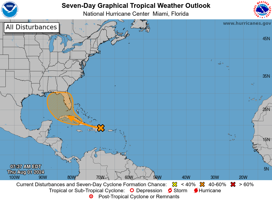
One reason for this is that it no longer appears as though the tropical wave will become Debby any time soon. A more rapidly strengthening system favored a poleward turn more quickly into the Atlantic. However, most of the model guidance now keeps the system below tropical depression strength for the next several days as it moves over Cuba and into the southeastern Gulf of Mexico this weekend.
If only what happened in the Gulf stayed in the Gulf. As the outlook from the National Hurricane Center outlook above makes clear, there is broad uncertainty about what happens to the system as it moves off of Cuba. It could conceivably move into Florida, or over any part of the eastern Gulf of Mexico. As of this morning most of the guidance favors a blob moving into the Eastern Gulf.
If the storm remains offshore, it would find more favorable conditions for development this weekend, or early next week. So it’s possible, and perhaps even likely, that we’ll see a tropical storm off the west coast of Florida in three to five days time. At a minimum, this will be a rainmaker. And depending on how strong it gets, there could be wind and storm surge threats as well. However, it is a fool’s errand to try and make such predictions now as there is a ton of uncertainty about a storm that a) has not yet formed, b) must still traverse the spine of Cuba, and c) may then interact with parts of Florida’s landmass. The bottom line is that residents of Cuba, Florida, and southern Mississippi and Alabama (and maybe even Louisiana) should be tracking the storm’s progress over the coming days.
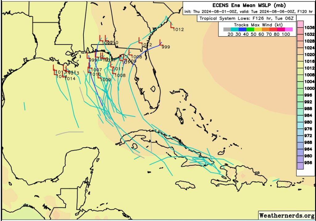
The party doesn’t end early next week, unfortunately. Let’s assume the system moves near the Florida Panhandle by Sunday or Monday. At that point it will run into an atmospheric pattern known as a “col,” not to be confused with the state or military rank. A col, in meteorology, means a place where a trough and ridge intersect. Essentially, due to weak steering currents, this tropical system could spin around and make some wild turns in such an upper air pattern.
For example, the European model brings the center of a very weak tropical system to the Florida Panhandle late next Monday, and then retrogrades the system back over the northern Gulf of Mexico for much of next week. The GFS model brings a strong tropical storm to the coastal bend region of Florida on Sunday, moves it all the way into the Atlantic Ocean off the Carolinas, before bringing it westward all the way back to Destin Florida and then Biloxi, Mississippi, before it finally lifts north on Tuesday, August 13. That’s 12 days from now!
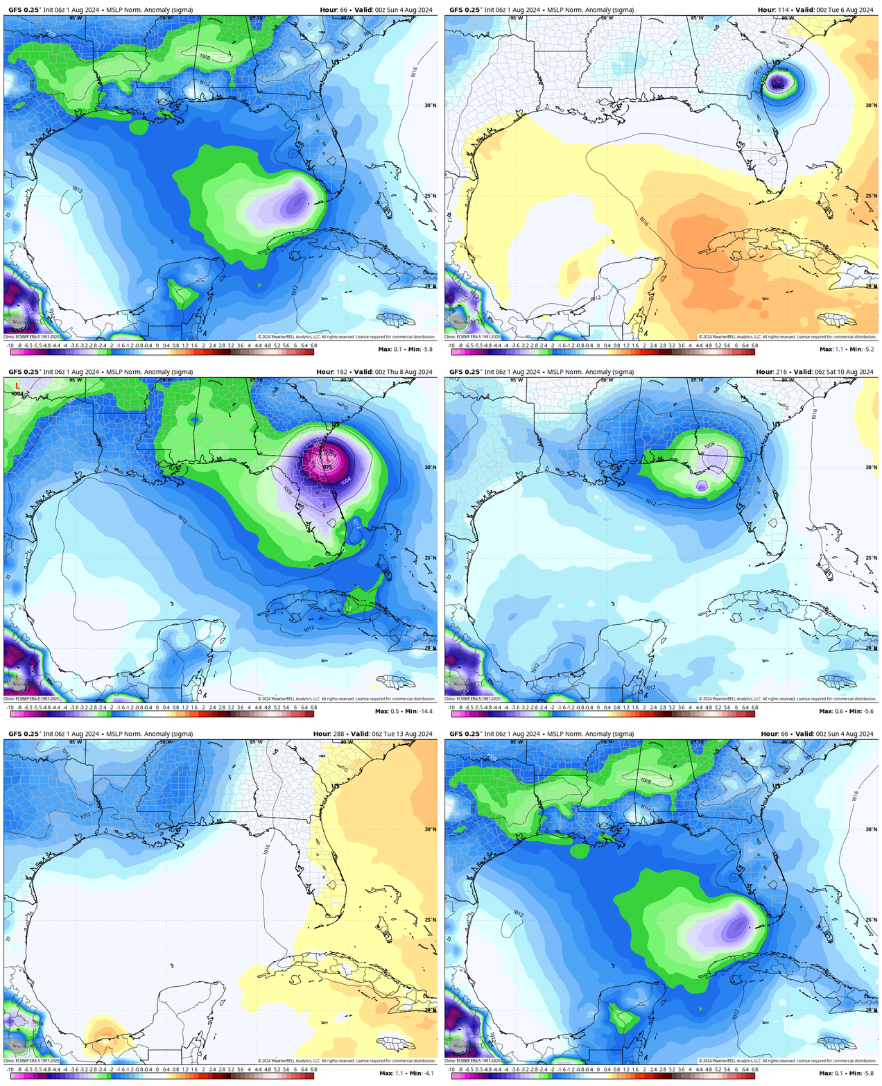
The bottom line is that Florida and the northern Gulf of Mexico coast need to buckle up and be ready for anything over the next week or 10 days. We just don’t know what is going to happen. My biggest concern, for the time being, is the potential for very heavy rainfall along the Florida Panhandle or the west coast of the state. However, as the storm evolves, so will the threats it presents to us.
In brief: This post discusses the month of August, and why it is the worst month of the year for weather in Houston. It also delves into our hot and hazy weather ahead, and takes a peek at a tropical system that’s near Puerto Rico and may be a rainmaker for Florida next week.
This month is named after the Roman emperor Augustus, who is considered by some historians to be Rome’s greatest ruler, and by others a tyrannical usurper. His greatest crime, however, is renaming this month after himself. Prior to that little matter of self-aggrandizement, the month was called Sextilis. That would have made an interesting naming choice for our hottest and steamiest month.
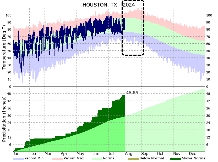
In any case, August is the worst month because it is the hottest month of the year in Houston. And we typically vacillate between the extremes of drought and flood, sometimes within a matter of hours. There is no happy medium. There is no break from the humidity. There is only August. It is also the month, alongside September, when we are most vulnerable to landfalls from major, destructive hurricanes. Now my colleague Matt Lanza will argue that September is worse. Why? Because September can also be hot, and there is the often false hope of a a cool front. But let me tell you, Lanza is dead wrong. I have lived through enough Septembers in Houston to know that we very often do get our first front in September, and it feels glorious.
Anyway, August is here. It’s always hot. It’s always humid. Let us fervently hope it is hurricane-free.
There will be plenty haze again today, which will fade the blueish nature of the sky, as we continue to see an influx of Saharan dust. This haze, at varying levels, should remain with us through Saturday or so. Otherwise, beneath high pressure, we should see sunny skies and hot temperatures in the mid- to upper-90s. Winds will be light, out of the south or southeast, at 5 to 10 mph this afternoon. Lows tonight will only drop into the upper 70s. And humidity—well, you should know whether to ask about humidity in August.
Temperatures will likely peak these days, with high temperatures likely in the upper 90s for much of the metro area. As mentioned above, we should still see a fair bit of haze from dust. However, beyond the haze we’re going to see sunny skies and rain chances below 10 percent. These will be good beach days or otherwise suitable for outdoor activities near water.
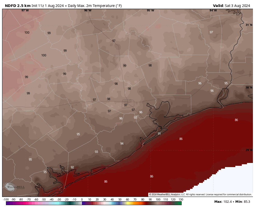
A weak front is going to near the Houston region on Sunday, and this may bring a few more clouds. (Although I’m still going to bet on mostly sunny skies). Rain chances will be a little bit higher, but still on the order of only about 20 percent daily. Temperatures may fall back a degree or two, into the mid- to upper-90s. Still, it’s going to be plenty hot.
We’ll continue to see hot and mostly sunny weather for much of next week, with highs in the mid- to upper-90s. There’s the slight potential for some sea breeze showers each afternoon, and maybe some slightly better rain chances toward the end of next week. But I’m not sold on that.
I’ll have more on the The Eyewall later this morning, but the forecast for a tropical wave that is now nearing Puerto Rico continues to fluctuate. For now it looks like a weaker system will move into the eastern Gulf of Mexico and eventually move north toward Florida. Then it may spin around awhile before finally lifting north. This is very likely not an issue for the Western Gulf of Mexico, but is definitely something to watch for Florida and parts nearby.