
WestJet said it had cancelled a total 1,137 flights across Canada as of Tuesday as a result of the mechanics' surprise strike over the long weekend.

WestJet said it had cancelled a total 1,137 flights across Canada as of Tuesday as a result of the mechanics' surprise strike over the long weekend.

Chris Carbert and Anthony Olienick are on trial charged with conspiring to commit murder at the blockade, which tied up traffic for two weeks at the busy Canada-U.S. border crossing at Coutts in 2022 to protest COVID restrictions and vaccine mandates.
Rudolph Giuliani, the former New York City mayor, federal prosecutor and legal adviser to Donald Trump, was disbarred in the state on Tuesday after a court found he repeatedly made false statements about Trump's 2020 election loss.
NPR's Ari Shapiro talks with Jeffrey Rosen of the National Constitution Center about expanded presidential power in the wake of the Supreme Court's decision in Donald Trump's immunity case.

The publishers’ lawsuit against our library is featured in the latest episode of “Why Is This Happening? The Chris Hayes Podcast.”
Listen in as Brewster Kahle, Internet Archive’s digital librarian, talks with Chris Hayes about the future of libraries, and what the publishers’ lawsuit means for libraries & their patrons in the digital age. Chris & Brewster are joined by librarian and lawyer, Kyle K. Courtney.
Streaming now on Apple Podcasts, Spotify, & TuneIn.

CAMBRIDGE, MA—In a Harvard CAPS / Harris poll conducted in the wake of the first presidential debate, new data revealed that any alternative Democratic candidate was likely to lose to former President Donald Trump, regardless of whether President Joe Biden was replaced as the nominee with Joe Biden, Joe Biden, or Joe…

Carlo Acutis, a devout 15-year-old who died of leukemia in 2006 and has been nicknamed “God’s influencer” for his popular database cataloging Eucharistic miracles, has been officially recognized by Pope Francis as a saint, becoming the first of the millennial generation to be given the title. What do you think?
NEW YORK CITY – Yesterday the NHL reinstated former Blackhawks staff Joel Quenneville, Stan Bowman and Al MacIsaac, confirming that 2 years is the maximum someone who covered up one sexual abuse incident and abetted another should be forced to not make millions for coaching or managing a hockey team. “Sure all three covered up […]
The post Report: going 2 years without getting paid millions to manage a hockey team sufficient punishment for abetting sexual abuse appeared first on The Beaverton.
WASHINGTON D.C. – In a 6-3 ruling, the United States Supreme Court ruled that former President Donald Trump not only has full immunity from prosecution for any gun murders he might commit, but that he definitely should do so. In a majority opinion handed down yesterday, the Court’s six conservative justices confirmed that, were Trump […]
The post Supreme Court rules Trump can and probably should shoot someone on 5th Avenue appeared first on The Beaverton.
by ProPublica
ProPublica is a nonprofit newsroom that investigates abuses of power. Sign up to receive our biggest stories as soon as they’re published.
In the wake of President Joe Biden’s poor debate performance, his opponents and most major media organizations have pointed out that he has done few interviews that give the public an opportunity to hear him speak without a script or teleprompters.
So much has been made of this limited access that the impressions from Special Counsel Robert K. Hur about his five hours of interviews with the president on Oct. 8 and 9 drove months of coverage. The prosecutor said Biden had “diminished faculties in advancing age” and called him a “well-meaning, elderly man with a poor memory.” Biden angrily dismissed these assertions, which Vice President Kamala Harris called “politically motivated.”
House Republicans on Monday sued Attorney General Merrick B. Garland for audio recordings of the interview as the White House asserts executive privilege to deny their release.
ProPublica obtained a rare interview with Biden on Sept. 29, nine days before the Hur interviews began. We released the video, which was assembled from footage shot by five cameras, on Oct. 1. We edited out less than a minute of crosstalk and exchanges with the camera people, as is customary in such interviews.
Today, we are releasing the full, 21-minute interview, unedited as seen from the view of the single camera focused on Biden. We understand that this video captures a moment in time nine months ago and that it will not settle the ongoing arguments about the president’s acuity today. Still, we believe it is worth giving the public another chance to see one of Biden’s infrequent conversations with a reporter.
The Interview With the Camera Focused on Biden The Interview as PublishedConducting the interview was veteran journalist and former CNN White House correspondent John Harwood, who requested it and then worked with ProPublica to film and produce it.
He did not send questions to the White House ahead of time, nor did he get approval for the topics to be discussed during the interview.
Recording began as soon as Biden was miked and sitting in the chair that Friday at 2:50 p.m. Earlier that day, Biden’s press staff had said the president would have only 10 minutes for the interview, instead of the previously agreed upon 20 minutes. We requested that the interview go the full 20 minutes. You can hear during the unedited interview a couple of moments when White House staff interrupted to signal that the interview should come to a close. Biden seemed eager to continue talking.

Hovertext:
You're in pillar of salt territory here, bro.

In a regular update on Tuesday morning, Mayor Jyoti Gondek said this marks the first step toward completely restoring the water supply and lifting remaining restrictions.
(5:30 PM CT update): Beryl is beginning to feel the shear as laid out in our post below, and it is now a category 4 storm with 155 mph winds. For folks in Jamaica, this offers modest comfort, as a major hurricane is going to make landfall (or come close) there tomorrow. Little has changed with respect to Jamaica and the Cayman Islands, so reference the post below on that.
I need to say some words to people in Houston. We are getting blasted by a few of you for apparently underselling the real threat from Beryl. If you read the post below, we’ve taken a very down the middle, neutral stance on the storm, explaining how it is still likely to pass to the south, though if it were to not weaken as much as forecast over the next 36 hours, it could come a bit farther to the north. We even went so far as to show the European ensemble models with the distribution of some closer to southeast Texas and others in Mexico, and we explained how this could be and what to watch for. I’m not quite sure what isn’t resonating with some people, but those are the facts. Here is a look at today’s most recent European ensemble members, 51 of them:
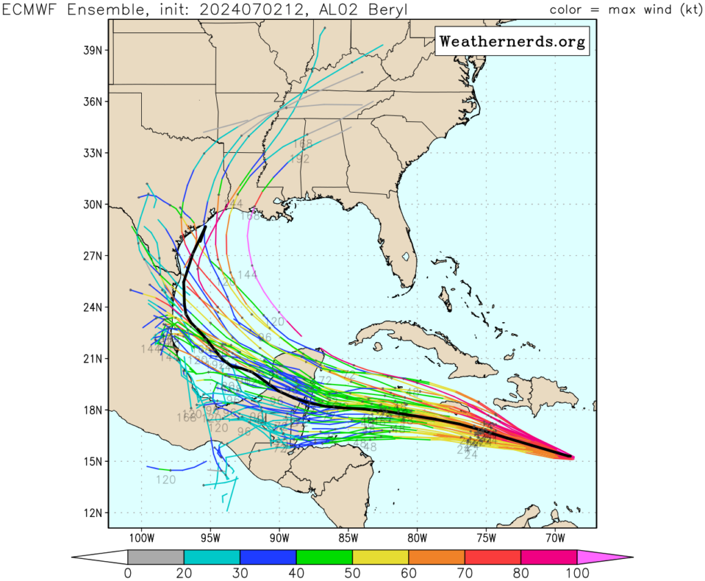
Of the 51 members, 5 of them or 9.8 percent bring Beryl into the Houston area or Louisiana. This is down from 8 earlier this morning. If you would rather the GFS Ensemble, 4 of the ensemble members, or about 13 percent bring it to Texas or Louisiana, the same as earlier. Roughly one tropical model (the HWRF) brings Beryl to Houston. The HWRF historically would handle a weakening tropical system poorly, so I would be apt to discount it in my weighting as a meteorologist with a number of years of experience tracking and forecasting these things.
I write all this to say: No one is saying to ignore Beryl. But, look, those statistics of objective model data imply that the risk to Houston remains…pretty low! Should we continue to watch this? Absolutely! And I laid out the case of how this could become more problematic in Texas below. So, let’s just take a breath and watch what happens over the next 24 to 36 hours.
Hurricane Beryl somehow managed to continue strengthening last night and achieved category 5 status late in the evening over the eastern Caribbean. It has maintained that status today and has 160 mph maximum sustained winds as it races west northwest across the Caribbean.
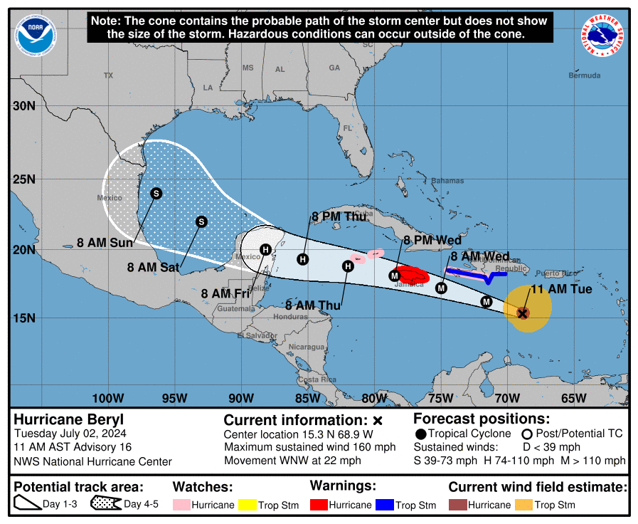
Over the next 36 hours, Beryl will remain on a course that should bring it very, very close to a direct hit on Jamaica. At the least, it will be a close pass, and hurricane conditions are expected there beginning late tonight or tomorrow morning. Preparations for a major hurricane impact should be rushed to completion in Jamaica. Folks in the Cayman Islands will need to watch Beryl closely as well as it passes near or just south of there tomorrow night.
On satellite, Beryl looked great this morning, and while it still looks great, there are at least some signs that shear is beginning to impact Beryl a bit on the west side.
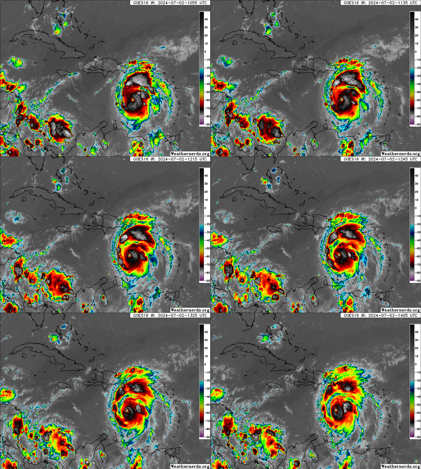
You can see a more ragged appearance to the eye and eyewall, and even what looks to be a little dry air just outside the core in the western semicircle of Beryl. Whatever the case, the thought is that Beryl’s intensity has peaked, and it should now begin to undergo a steady decline. Beryl is about to plow into 20 or more knots of wind shear.
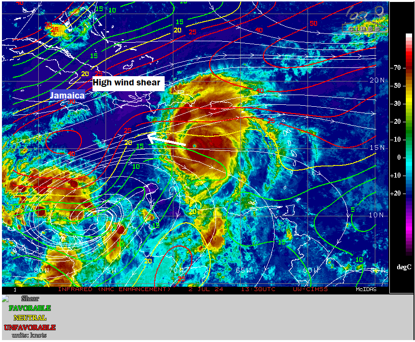
Wind shear is complicated with storms of this intensity. Theoretically, it should just start to feel the shear and begin a steady, if not rapid weakening. Modeling says this will be the case. The majority of modeling weakens Beryl to a category 2 or weaker storm by Thursday morning. But in storms of this intensity, shear can be a little funky and find ways to help the storm “ventilate” somewhat. In my opinion, this is not going to be the case with Beryl; it should weaken as forecast, perhaps at a slower rate than what models suggest. However, there is inherent uncertainty here, and that’s why we would tell folks in Jamaica to prepare for a serious, major hurricane.
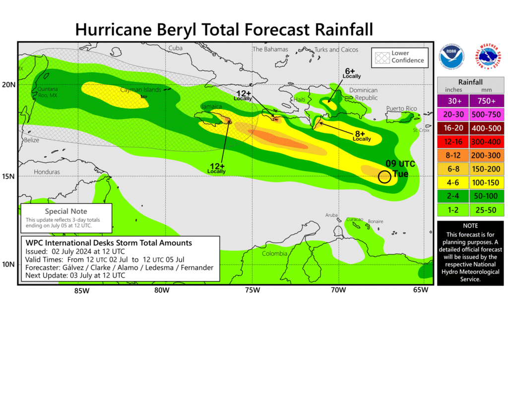
In addition to the wind and surge impacts of a major hurricane, flooding from rainfall is a possibility, if not likelihood as Beryl passes southern Hispaniola and Jamaica.
According to Sam Lillo of DTN weather, who has been posting frequent statistical nuggets on Twitter/X regarding Beryl’s unprecedented nature about Beryl’s forward speed. Over a 6 hour period, Beryl is the fastest known moving category 5 storm on record. As noted by him and some others, Hurricane Allen in 1980 and Janet in 1955 also had some extreme forward speeds for category 5 storms. Either way, Beryl will end up atop or near the top of many charts once all is said and done for earliest and easternmost and fastest for storms of this intensity.
What comes after Jamaica for Beryl?
The main near term concern is for the folks in Jamaica and the Caymans. Beyond that, the forecast is contingent on a number of factors. Over the last 48 hours, we’ve seen a slight northward shift in Beryl’s forecast track as it comes west.
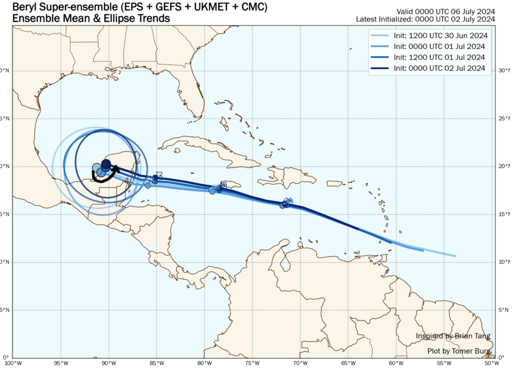
This has implications for the Yucatan and perhaps the Gulf as well. Why is Beryl trending more north? For one, exploding into a category 5 storm allows it to gain some added latitude. But secondly, the U.S. pattern has changed somewhat. If you look at how the European ensemble’s 6 to 10 day forecast has changed in the last 48 hours, the tendency has been for the trough over the Central U.S. to strengthen, thus weakening the ridge of high pressure in the South.
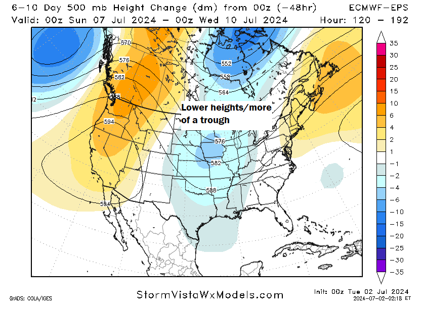
But there’s a lot of nuance to this. For one, if Beryl does weaken as expected, this would have only a modest impact on the final track, keeping it south across the Yucatan and into Mexico. If Beryl does stay stronger than forecast or somehow intensifies as it comes west into the Gulf, it would be more apt to “feel” the stronger trough and come north. You can see this on the Euro ensemble where stronger outcomes are mostly skewed north and weaker outcomes are mostly skewed south.
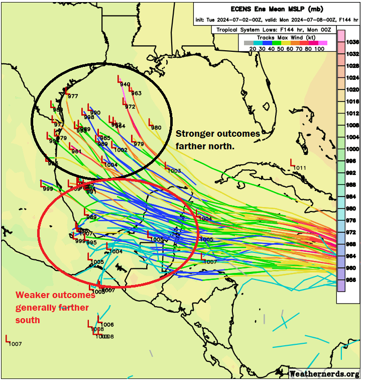
There’s a reason we have been apt to not speculate on what would happen to Beryl as it came west, rather trying to focus on what would impact Beryl. These changes offer a wrinkle. Should you worry on the Texas or Louisiana coasts? No, but you’ll want to keep an eye on this. For one, there seems to be a fair bit of support for somewhat hostile upper air conditions in the Gulf when Beryl arrives, so there’s no guarantee this will just explode when it gets there.
That said, we’re operating in a very odd world right now. Gulf of Mexico water temps have drifted under record levels thankfully, but it’s still warmer than normal overall. So I don’t want to overpromise anything at this point. The best we can tell people to do is continue watching. If Beryl makes it to the northern Mexico, Texas, or Louisiana coasts, the impacts would probably begin late Saturday night or Sunday.
One other quick word: A lot of people will be traveling this weekend to beaches and such. Rip current risk in the Gulf is going to increase later in the weekend as some of the swells from Beryl reach the coast.
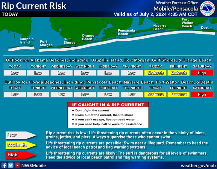
Please use caution if you’ll be on the beach this weekend. Even the best and most experienced swimmers can struggle with rip currents, so it’s advised to swim near a lifeguard and follow any warnings or caution notices.

WASHINGTON—In a partial victory for the former president, the Supreme Court ruled this week that Donald Trump has immunity for any crime committed between the hours of 9 a.m. and 5 p.m. during his time in the White House. “Whether it be bribery, fraud, assassination, or a coup, the president is entitled to immunity…
Montreal has released its new 2050 Urban Planning and Mobility plan (only available in French), and I haven’t seen nearly enough talk about it (there has only been a little chatter on Twitter and Mastodon). And so I thought it would be nice to write an article on my thoughts on the plan — where it makes sense, and where it does not.
If you enjoy my content, consider subscribing to my blog:
or supporting me on Patreon:
Your support will help me bring you more content faster!
On the non-transportation front, there is obviously lots to like.
The plan talks about a lot of the same themes we’ve been hearing across the country — more housing near transit, intensification, and amenities within walkable distance. At the same time, I appreciate that the plan makes clear that more substantial intensification makes sense near higher capacity transit modes — something that is far too often not acknowledged.


What’s silly though is that higher amounts of density are suggested near trams than BRT, despite the difference in capacity being small if it exists at all. What is nice is that as part of the plan parking minimums are set to be dropped, which will help with housing costs as well as building the number of people who do not have cars and thus need to walk, cycle, and use public transport.
The first really interesting diagrams, which can be found here on page 11, show the proposed or “visionary” transit network for 2040 — 16 years from now.

On this map you can see a few things: The Blue Line extension and the REM are totally completed, and the Orange Line’s west leg is extended, not just to Bois France — a very good project which will effectively increase capacity and connectivity for the REM network with only a few hundred meters of new tunnel and a station — but beyond to Laval.
You can also see a very substantial increase in the number of “SRB” or BRT routes, which interconnect quite heavily with one another. This is good of course, but I think not nearly enough attention is given to the fact that if the same approach that was taken for the Pie-IX BRT is taken with these projects, there is simply no way they will be done by 2040. The Pie-IX BRT took years to plan and at least five years to build (some elements are still not done) and is just 13 kilometres long. The amount of new BRT that appears to be planned here is several times that, and I don’t think there is any attempt to grapple with the extremely long timeline and unnecessarily onerous works that happened as part of the city’s first “modern” BRT.

What’s worse than the plans for BRT though are the tramway routes, which appear to total at least 50 – 80 kilometres in length of something Montreal has never built in the modern era.
Included in the planned tramways is the ARTM’s inferior REM de l’Est alternative (that would apparently link to a tramway going downtown — which was disallowed for the REM because of a belief it would cannibalize Green Line ridership). The tram plans (besides the extremely long ones towards the airport and the ARTM line in the east) are not horrible and are similar to other previously proposed routes, replacing busy urban buses with trams. There is also no prioritization showing how the rather large network of lines (including an odd amount on the southwest) would be staged, and not many lines through the fast developing areas around Griffintown and the Peel Basin, which feels like an odd choice.
Fundamentally however, the big problem is that there is no recognition of the reality of the cost (at least in Quebec at present), timelines, and planning problems with the trams. If Quebec City after all of its struggle is barely able to get a neutered tram project for less than several billion dollars, how will Montreal ever be able to build one, much less all of these lines?

The second outlined plan is for 2050 (page 12), and this highlights what Montreal’s transit network is envisioned to look like in 25 years.
I’d like to remind people that very little has been achieved in terms of Metro or STM driven transit expansion in the last 25 years (since 1999 we’ve only got the 3 stop Laval Orange Line extension). It just feels wrong to even imagine that within 25 years, three metro extensions, a new metro line, and a ton of tram and BRT lines will all be done — far more than in the last 25 years, even with skyrocketing costs. And there appears to be almost no interest on reflecting on this, or expanding on the methods that enabled the low-cost REM project. Instead, all sights and hopes are set on the perennially almost-here tramway, which will surely save the city.

To be more specific, versus 2040, it is assumed that by 2050 there will be yet another big addition to the tram network, with new lines to the north, west, and east of the island, and a few more in the core as well. These lines are probably mostly fine, but they seem needlessly road-oriented, which leads to weird places where you have two lines closely paralleling one another in order to maintain alignment to roadways, while also oddly avoiding connections to say… new REM stations.

At the same time (I could be missing something), it appears that the 2040s are meant to net the city essentially no new BRT, which is odd — if the city is meant to get good at cost-effectively building anything, this is not the way to do it. There are also some obvious gaps that still aren’t plugged (again see above), where there are lots of lines but few connections. It sort of feels like someone wanted to slap lots of lines down, but didn’t go beyond that to ask how they might be used, how the network design would influence the formation… of a network, and how things could be built out in an effective way. It feels unsophisticated.
On the metro side, 2050 is meant to come along with a very useful extension of the Blue Line to Montreal West, which would be a nice follow up to the current Blue Line extension, but which seems unlikely to be built at current prices. Meanwhile, the Pink Line rears its head, but it doesn’t really seem to be adjusted at all from previous plans, even if the enormous number of trams as well as the REM clearly will have an impact as well as open new opportunities.
On the whole, I am disappointed. Montreal has pretty good transit today, but its plans seem to mostly not revolve around the things it does well (metro/REM) and the problems with them (construction cost), and instead focuses on BRT (in a slow and expensive Pie-IX-type orientation instead of a logical Vancouver RapidBus approach), which Montreal has struggled a ton to get built and trams which the city does not have. It doesn’t feel like vision so much as a poorly-informed dream.

CLEVELAND—Lacking a North Star to guide him through his workday, local office worker Evan Pullman was reportedly lost like a sailor in a maelstrom Tuesday after the human resources department at Edgemere Industries failed to send out the company’s quarterly update. “Dear God! Without an email newsletter recapping our…

NEW YORK—In a report released Tuesday that has been hailed as equal parts fascinating and perplexing, researchers at Columbia University found that requests to prove one is not a robot have gone up 400,000% over the past 500 years. “During the Elizabethan era, for example, people were rarely asked to prove they were…
In brief: In the main, our hot and sunny weather will continue through the rest of the work week. We have no weather concerns for the Fourth of July, aside from heat. Our overall pattern may change this weekend, with slightly cooler temperatures and increasing rain chances due to moisture from Hurricane Beryl.
The forecast for the forthcoming holiday, on Thursday, is straightforward. High pressure should be firmly in control of our weather, and this will lead to a hot and sunny day. High temperatures on Thursday will hit the upper 90s for much of the city, with coastal areas remaining in the lower 90s. Winds will be light, from the south, at 5 to 10 mph.
Temperatures at the time of fireworks, about 9 pm for most locations, will be in the upper 80s, with partly to mostly clear skies. There is only about a 10 percent chance of rainfall during the daytime, so there should be no concerns on that score. However, our ‘excitable dogs’ scale will be a 10 out of 10 given that most of our canine friends do not enjoy fireworks. Enjoy the holiday, everyone!
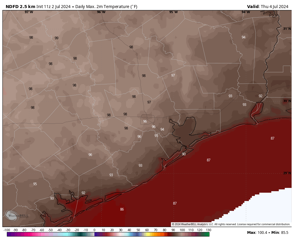
Today, like much of our recent weather, will be mostly sunny and hot. Most of the city will reach the upper 90s, with light winds. There remains plenty of moisture in the atmosphere, but high pressure (which promotes sinking air, rather than the rising air conducive to showers) will keep a lid on activity for the most part. Expect only perhaps a 10 percent chance of rain this afternoon and evening. Lows tonight will only drop to around 80 degrees for most locations.
Temperatures will be warm again on Wednesday, although we might be a few degrees cooler. In addition, we may see a few showers streaming in from the coast, so I’m going to bump rain chances up to about 20 percent. As for humidity, well, do you have to ask about humidity in Houston in July?
The end of the week will see more hot and sunny weather. We’re taking temperatures in the mid- to upper 90s, with lots of sunshine and only low-end rain chances.

Our overall pattern may begin to change on Saturday as high pressure begins to back off a little bit. Our temperatures should come down a few degrees, and rain chances increase. The changes will be modest, but by later this weekend our high temperatures should drop into the lower 90s, with daily rain chances increasing to perhaps 40 or 50 percent. This may persist into next week, depending on what happens with Hurricane Beryl and its moisture.
As it moved into the Caribbean Sea on Monday, Beryl had an astonishing burst of intensity for early July, reaching Category 5 status. There is fairly high confidence in the forecast between now and Friday, when the storm will likely move into the Yucatan Peninsula. A weakened Beryl will then move into the southern Gulf of Mexico.
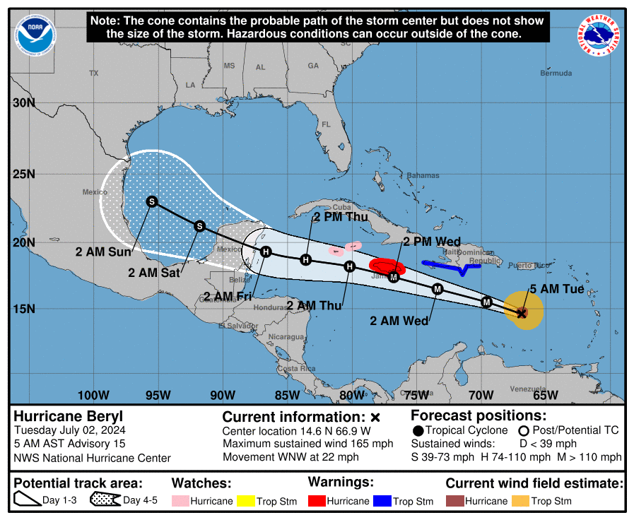
After that time the system will most likely remain bottled up in the southern Gulf of Mexico. However, given the trend toward weakening high pressure over Texas, some of the the moisture from Beryl could work its way north. This will influence the extent to which Houston sees increased rainfall chances late in the weekend and next week. Is there a scenario in which Beryl becomes a bit more organized and its center tracks toward Texas? Yes. But for now this seems less likely an outcome than just increased rainfall chances for the greater Houston area. We’ll keep a close eye on it all.
For more on Beryl, be sure and check out our detailed forecasts on The Eyewall.
Thanks to Eric and Matt for the hot and sunny July 4th forecast!
Throughout the peak summer travel season, many people often wonder what is best practice for cooling
an empty house – and if it’s even worth it. And for those staying home, staying comfortable while
hanging out around the house doesn’t have to run up the electric bill. Check out these energy efficiency
tips from Reliant to stay cool and save money, regardless of your plans for the holiday weekend!
Traveling for the 4th:
Enjoying the holiday from home (in addition to the above):


WASHINGTON—Revealing they had holed up in Camp David beforehand and grilled him nonstop for a week straight, President Joe Biden’s team confirmed Tuesday they were proud their hours of grueling prep had successfully gotten him through a meeting with his family about continuing to seek reelection. “It was admittedly…

THE HEAVENS—Groaning as He surveyed the massive piles of souls, a stressed-out God confirmed Tuesday that He had not realized He was supposed to reincarnate all those dead people. “Oh, shit, that was my job?” said the Lord God Almighty, who shook His head and muttered, “There’s, like, 117 billion of these things,” as…
In brief: As a boundary pushes in from East Texas, the potential for storms is a little bit higher today than expected. However, while the line of storms currently on the radar is impressive, it’s not clear whether this system will hold together all the way into Houston.
In this morning’s post I mentioned there was “a bit of intrigue” regarding storm chances on Monday afternoon as a boundary pressed into the area from the east. As of 4 pm CT this boundary is clearly visible on radar, having moved from Louisiana into East Texas, and now slowly creeping toward the Houston metro area.
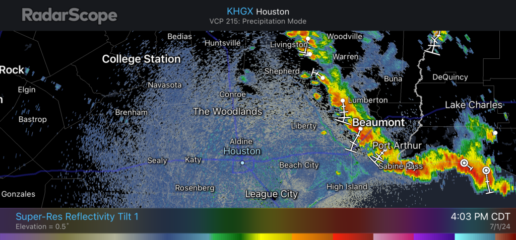
To be frank, our high-resolution modeling guidance has completely missed the boat on this storm development today, and I don’t have a great answer as to what happens later this afternoon and evening. My best guess is that this boundary will continue to slide west, but as the storms approach and move into the Houston area they will weaken. But given the ample daytime heating over the next couple of hours, it is also possible the storms hold together and some sort of line pushes through between now and 9 pm CT.
With this post I simply wanted to call attention to the possibility that showers and thunderstorms may be a little bit more widespread this evening than previously expected. (We have no flooding concerns, regardless). Or, maybe the storms will fizzle out as they move into a slightly less favorable environment. In any case, expect the unexpected this evening.
