60 years after Martin Luther King Jr. gave his famous "I Have a Dream" speech, we hear from one of the men who helped him write it, his friend and attorney Clarence B. Jones.
(Image credit: AFP via Getty Images)

60 years after Martin Luther King Jr. gave his famous "I Have a Dream" speech, we hear from one of the men who helped him write it, his friend and attorney Clarence B. Jones.
(Image credit: AFP via Getty Images)

Florida officials reported "potentially widespread" diesel contamination in gasoline in the Tampa area Saturday, raising alarm that car engines and power generators could break as the storm nears.
(Image credit: Joe Raedle/Getty Images)


Forecasters warn of the possibility of dangerous storm surges caused by Idalia and Florida Gov. Ron DeSantis has suggested that some residents in coastal areas may have to evacuate.
(Image credit: NOAA via AP)


The judge overseeing a criminal case against former President Donald Trump for interfering with the 2020 presidential election has set a trial date of March 4, 2024.
(Image credit: Evan Vucci/AP)


Florida Gov. Ron DeSantis visited Jacksonville on Sunday to mourn the three victims killed in a racially motivated shooting at a local Dollar General.
(Image credit: John Raoux/AP)

Franklin has intensified into a major hurricane, with 130 mph sustained winds, overnight; but the bigger threat to land is Tropical Storm Idalia, which could become a major hurricane before striking Florida’s Gulf coast later this week.
We’re going to start with Idalia, because that poses by far the biggest threat. As of this morning, Idalia is nearing hurricane status with 65 mph winds, and it will probably reach that milestone later today. Unfortunately, it is likely to strengthen further over the next two days as it crosses over Gulf of Mexico waters that are extremely warm and, critically, moves into an upper atmosphere that should not significantly hamper intensification. For now, the National Hurricane Center forecasts that Idalia will become a Category 3 hurricane prior to landfall, but the storm could easily be a category stronger or weaker by Tuesday night as it nears the Florida coast. The one saving grace here is that Idalia will only have a little more than 24 hours over the open Gulf of Mexico waters to strengthen, and some modest wind shear may limit its ceiling.
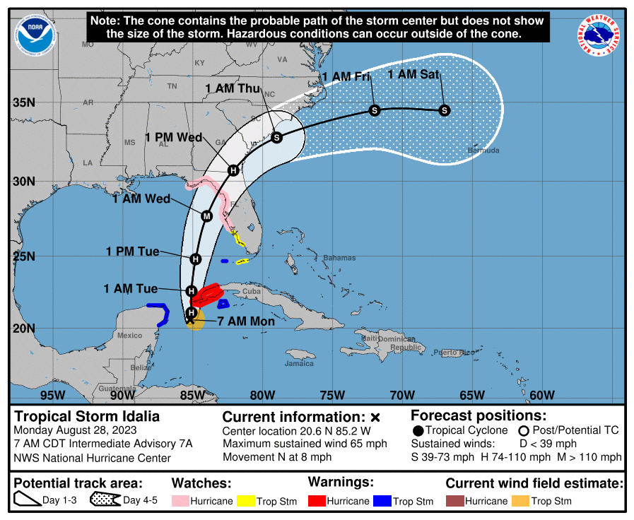
So where will Idalia go?
Later today the storm will cross the far Western edge of Cuba, and then move into the Southeastern Gulf of Mexico. After that it will move north-northeast, toward Florida. Our best forecast models are increasing in confidence, but there’s still some uncertainty in where Idalia’s most devastating winds and storm surge will go. The most likely area for landfall is the Big Bend area of the Florida coast, but a landfall from Panama City down to Tampa remains possible. The populated area of Tampa is on the right side of the storm, susceptible to the strongest winds and storm surge. However, based upon our best forecasts right now, the Tampa region would miss out on Idalia’s worst. But it’s going to be close.
Hurricanes produce three major threats: inland rainfall, storm surge, and damaging winds. In Idalia’s case, inland rainfall is slightly less of a concern because the storm is expected to maintain a reasonably high forward motion on Tuesday and Wednesday, as it crosses Florida and Georgia. That is not to say there will not be inland flooding from Idalia, particularly in areas such as Georgia and the Carolinas, but it should be mitigated by forward speed.
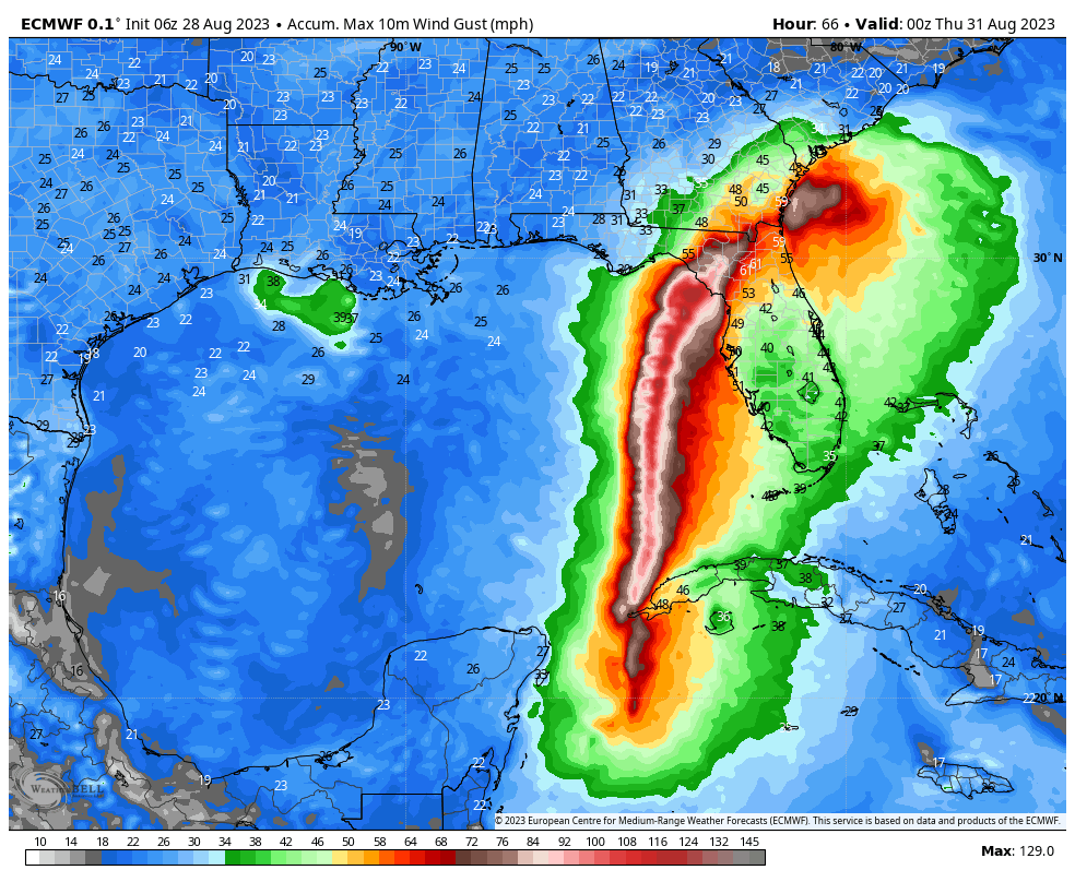
So the bigger issues are likely to be storm surge and damaging winds. Both of these effects will be most intense along the line of the storm’s track, and to its right-hand side. We can see this in the forecast “wind gust swath” from the European model. Now this is just one model run, and most definitely subject to change, but it gives you a sense of how the worst of the winds will be relatively localized, near the core of of the storm. Wind gusts of up to 130 mph are possible, based on this forecast.
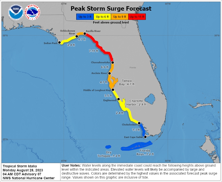
As for storm surge, this again will depend on the track’s location. For now the worst of it looks to occur in the Big Bend area of the Florida coast.
We will have an update on Idalia later today. The bottom line is that if you live in Florida, including the Tampa area, today is the last full day to make preparations for the impending storm. This is a storm to be taken seriously. Tropical Storm-force winds could arrive in parts of the state as early as the middle of the day on Tuesday.
Franklin has continued to strengthen overnight, and as of 7:35 am ET this morning the National Hurricane Center reported that the storm had reached sustained winds of 130 mph. Some further strengthening is likely later today as Franklin continues passing over warm waters and enjoys low wind shear.
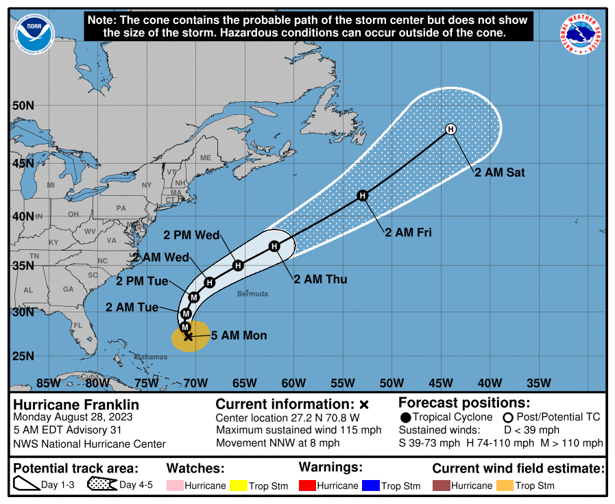
Fortunately—very fortunately—Franklin is behaving for a storm in the Western Atlantic Ocean. Its projected track will follow a course far enough off the Atlantic seaboard of the United States to spare the coast of any significant effects. Moreover, Franklin should remain just far enough west and north of Bermuda to also spare the small island of its worst effects. Some tropical storm warnings may still be necessary for Bermuda, but it should be miss out on anything close to the worst of what the Atlantic season’s first major hurricane could dish out.
So go on Franklin, get on with your bad self.
After Franklin and Idalia there is another system likely to develop from a tropical wave that will move off Africa on Tuesday. However, we don’t anticipate that this system will track toward the Caribbean Sea or the United States. It likely is not a concern as we head into early September.
Maybe. The very worst of it is, at least.
But first, let’s recap the story of this summer so far. From mid-June onward, Houston has recorded some of the very hottest temperatures on record, with July ranking as the city second warmest July (behind only July 2022), and this August on pace to be the hottest August in 150 years of records. For example this month, on Thursday and again on Sunday, Houston matched its hottest temperature of all time, 109 degrees. It has been non-stop brutal.
I am not going to sit here and predict that we’re done with 100-degree days. But I do feel reasonably confident that we’re done with the absolutely scorching days of 105-degree plus temperatures that we’ve experienced of late. Houston will now return to a somewhat more “normal” summer in terms of temperatures. Still quite hot, but probably not extremely hot.
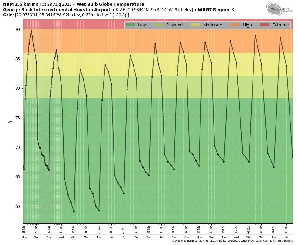
A very weak front has moved down into the region and more or less stalled along the coast, and it should eventually bring some drier air behind it. Skies today will be partly sunny for much of the region, with high temperatures in the upper 90s to 100 degrees. There will be a decent chance of showers later today for areas along and south of Interstate 10, perhaps 40 percent, but don’t expect accumulations over more than a tenth of an inch of rain, or two. Chances further inland are probably less than 20 percent.
As the front pushes all the way off the coast, this should help to limit high temperatures in the upper 90s. Skies will be mostly sunny with light northerly winds. There is perhaps a 10 percent chance of rain for coastal areas, and virtually no chance further inland. Lows on Tuesday night will drop into the 70s in Houston, with some readings in the upper 60s possible for far inland areas. This is a small promise of what’s to come (hopefully) in a few weeks with the season’s first real front.
This should be the driest day, in terms of low humidity. Still, with clear skies and drier air, we can expect high temperatures near 100 degrees for much of the area. The good news is that evening temperatures will cool off more quickly with the drier air.
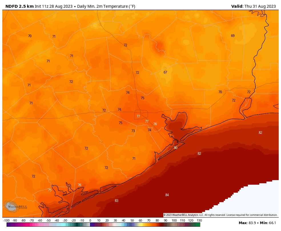
We’ll start to see humidity levels coming back up some, but these days still shouldn’t be oppressively humid. Look for highs in the upper 90s to 100 degrees, with sunny skies and no chance of rainfall.
The weekend looks hot and mostly sunny, with high temperatures in the upper 90s to 100 degrees. Some rain chances will return to the forecast as air moisture levels rise, and we could see the sea breeze spark some activity. For now, call it a 20 percent chance of rainfall each day.
Next week should bring more of the same weather, with highs most likely in the upper 90s (cannot rule out some 100 degree days) and rain chances on the order of 20 to 30 percent as the sea breeze kicks up. The bottom line, I think, is that extreme summer is going away for a while, to be replaced by a-bit-hotter-than-normal summer. I think that’s OK after what we’ve been through?
The Atlantic tropics are sizzling right now with a major hurricane in Franklin, and Tropical Storm Idalia. The latter is the bigger concern, as Idalia will menace Florida as potentially a major hurricane later this week. We’ll have full coverage, as usual, on The Eyewall website.

This post was written by Alison Green and published on Ask a Manager.
A reader writes:
I was part of a mass exodus from my former employer, and most of us left because we didn’t want to continue working with our director, “Ken.” I can spare you the details, but Ken is completely awful. I saw wonderful coworkers who were otherwise completely pleasant and professional be reduced to crying, swearing at Ken, raising their voices to him, and rage-quitting meetings with him. It might not be an exaggeration to say that working with Ken was seriously traumatic, as many former employees, including me, have had nightmares about him since leaving. I gave direct feedback to Ken, as well as Ken’s boss and HR (and I know other people did as well), but we never saw any significant changes in his behavior. There have been a slew of Glassdoor reviews from both current and former employees referencing Ken being terrible to work for/with.
A lot of us are wondering why Ken hasn’t been terminated. So much good talent has left or is leaving because of him, and it’s baffling why the company continues to let this happen. I’ve heard all of the possible reasons being speculated:
1. The higher-ups somehow, despite the direct feedback and it being all over Glassdoor, don’t know how terrible he is.
2. Ken has dirt on his boss and has blackmailed them into keeping him on.
3. Ken’s part of a protected class and the company is afraid to fire him because they think it would be a liability (I hate to bring this one up, but this is how much people are grasping at straws).
4. The higher-ups think that you have to do the terrible things Ken is doing to get results out of people.
5. The higher-ups are using Ken to get people to quit so they can avoid laying people off.
Of all of these, I think 4 and 5 are the most likely. However, I don’t think the data would support 4. Ken was on parental leave last year, and I’m pretty sure the numbers would show that people were more productive when he wasn’t there (I’m kicking myself for not doing the math when I had the chance). They were certainly happiest when he was gone. That leaves 5 as the most likely candidate in my opinion, although it sounds far-fetched. On the other hand, our industry has been plagued by layoffs recently and the company’s business outlook isn’t great, so a Ken-induced mass exodus could be a way to get a lot of people to resign while not doing an official layoff. Almost none of the positions left empty by folks resigned have been backfilled due to budget constraints, which is partly why I think it’s 5.
I’m curious for your thoughts about this situation, and in general why terrible people aren’t fired.
In the vast majority of situations like this that I’ve seen, it’s none of those explanations! It’s much more common for it to be reasons #6 or #7:
6. Wimpy management above the terrible employee — management that’s too weak and/or conflict-averse to take the sort of action that results in real change (whether that’s getting the terrible employee to behave differently or firing them). This is so, so common.
or
7. Management above the bad manager values his non-management contributions more than anything else. If Ken is fantastic at something they really prioritize — especially something that brings in a ton of money — some companies will care about that more than the fact that’s he’s a bad manager who’s driving people away. This is usually short-sighted because there’s a point where the cost of constant churn is higher than whatever benefits the problem person brings … and in addition to that, there are opportunity costs to having someone like this on your staff: who’s to say what creative and revenue-generating initiatives people might come up with if they weren’t living in fear of Ken and trying to work around him, or what strong hires they’re missing out on because Ken has a reputation and people don’t want to work for him, or how many junior people could have blossomed into high contributors but aren’t because Ken stifles them or drives them out of the field entirely? But it’s very, very, very common for people to get away with bad management because they’re really good at something else.
Now, in your situation, it’s possible that it’s actually your explanation #5 (wanting people to quit so the company can avoid layoffs) but I’m skeptical … because generally when you need to shrink your staff, you want to pick the people who leave and the roles you’re cutting, and not just cut positions indiscriminately. When people flee a Ken, you’re most likely to lose your best people first — the ones you least want to want to lose — because they have the most options. If achieving lower staff numbers is their goal, this would be an incredibly messy and ineffective way to get there.
Also, a legal note: everyone is part of a protected class, because protected classes are things like race (not just race X), gender (not just gender X), and so forth. So it takes more than membership in a protected class for a discrimination suit, although some groups are more likely to need the protection of anti-discrimination laws than others.

JERSEY CITY, NJ—In the tragic wake of her unexpected passing, sources confirmed Monday that a grandmother’s sudden death forced local parents Wilson and Patricia LaRusso to explain to their children what happens when you snitch. “Well, buddy, Gran-Gran was a rat—do you know what that is?” Wilson LaRusso said as he and…

MOSCOW—Returning from beyond the grave to seek revenge on Vladimir Putin for the Russian president’s suspected involvement in his untimely death, the late oligarch and Wagner Group founder Yevgeny Prigozhin has begun marching toward the Kremlin with an army of 25,000 undead soldiers, sources reported Monday. “I live…

DURHAM, NC—Appearing saddened as they explained it was a congenital defect and there was almost nothing they could do, doctors at Duke University Hospital expressed alarm Monday after early tests suggested that a pregnant woman was Black. “We are so sorry, and we understand this is absolutely not the news you wanted…
Neon lights on diner signs are a vibe.
Neon lights as art is not a vibe.
Midcentury modern is no longer a vibe.
Art Nouveau is back in vibe.
Scandinavia, the area of the world, is a vibe.
A vibey restaurant is not my vibe.
A vibey bar is trying too hard to vibe.
A vibey club is the point of the vibe.
Doing a vibe check every time you go out is not a vibe.
Worrying about vibe-shifts is not a vibe.
A vibe is not to be confused with having a “moment” (i.e., “You’re having a sequins moment” or "I’m loving this sneakers moment on you”).
Sequins with sneakers is a vibe.
Vibing with someone on a date is a rare and special vibe.
Good therapy is an expensive vibe.
Toxic air quality is not a vibe.
Umbrellas are a vibe.
Rainbow sunsets are a vibe, as long as you don’t think about the pollution causing the vibe.
Adaptogens are an over-marketed vibe.
Twitter/X is not a vibe.
Threads is a TBD vibe.
Zoë Kravitz is both goals (RIP word) and a vibe.
“Coaches” on Instagram, who have no actual credentials, are not a vibe.
Vibing to a song by dancing like everyone is watching because you’re getting the party started and no one can compete with your move called “The Vitamix” is a vibe.
Balloons, baskets, and books are a vibe.
A baby is a vibe, if you’re going for that vibe as part of your life plan.
Four babies is a flex, not a vibe.
Democracy is a dying vibe.
America is a complicated vibe with a problematic history.
The word “problematic” is meaningless and not a vibe.
New York City is mostly a vibe.
LA can be a vibe.
San Francisco used to be a vibe.
New Jersey is not a vibe.
Big-city elitism is not a vibe.
Clichés in humor are an inevitable—because they’re accessible—vibe.
Cats are a quirky vibe.
More than two cats are not a vibe.
Small to large dogs are a vibe.
Dogs that fit in a purse are too small to be a vibe.
Extra large dogs are horses and not a vibe.
The sun is a vibe.
Thinking about what the sun actually is turns into an existential vibe.
The moon is a mood-setting vibe.
Seeing the moon in the daytime is a joyous vibe every single time.
Climate change is not a vibe.
Wes Anderson’s latest movie is a “too-much-is-happening-story-wise” vibe, so much so that it takes away from the “Wes Anderson” vibe.
Saying “vibes,” as in an abbreviation used since the 1920s for the percussion instrument vibraphone, is a vibe if you’re a musician.
Max (formerly HBO Max) could be a vibe if they’d either let me buy individual shows or bundle with Netflix, Disney+, and every other streaming network, because no person can subscribe to twenty-six different networks, so a re-bundling has to be inevitable! Frustrating vibes.
Someone with bad vibes is not a vibe.
Someone with good vibes is not necessarily a vibe, but they’re still a nice person.
Someone with chill vibes is a vibe.
I am a vibe!
You are a vibe!
Our friendship is an unbreakable vibe.
Until it stopped being a vibe when you got mad at me because I didn’t hire you as my real estate agent.
If you’re feeling creative vibes, stop everything you’re doing and hold on to that vibe!
If you have high vibes, you’re probably just high.
Saying something is a vibe is not a vibe.

Hovertext:
People who say microeconomics isn't useful in real life are simply not being creative enough.
Hurricane and storm surge watches are now posted along much of Florida’s west coast and parts of the Panhandle as Idalia is expected to bring impacts by Tuesday.
Tropical Storm Idalia (pronounced “ee-DAL-ya” for those that were not sure) formed this morning, and quite frankly it looks no better organized now than it did then. So in essence, not a whole lot has changed from our morning post.
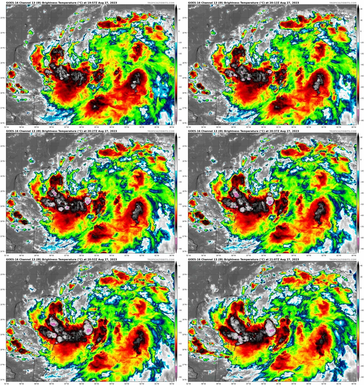
This was mostly expected. Idalia is unlikely to really get moving in terms of intensity until it start getting a lift north, meaning a lot of the intensification we see from this storm may not occur until it’s rather close to land. Idalia is not exactly a small system, with thunderstorms extending from the Yucatan to east of the Isle of Youth in Cuba, which is about 400 to 500 mile wide swath of unsettled weather. To underscore, while the track of Idalia does matter, one need not be close to the center to feel the impacts of this storm as it comes north.
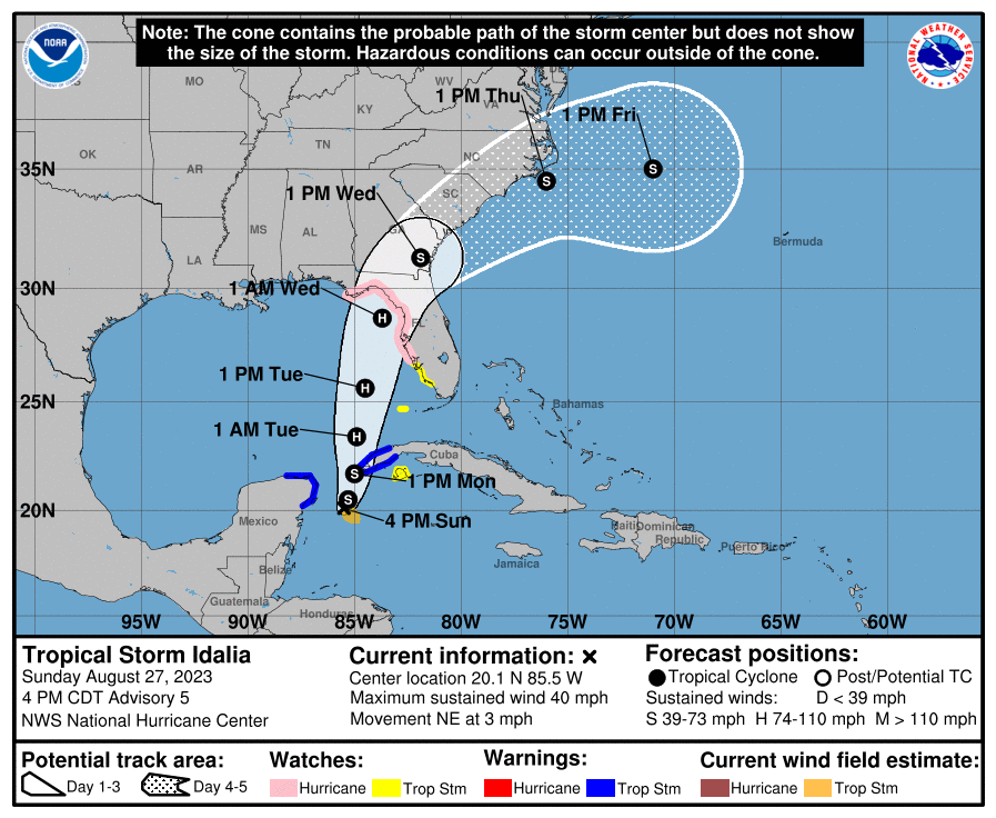
The track forecast today has not seen any dramatic changes, so, broadly we still expect a hurricane approaching the eastern Panhandle, Big Bend, Nature Coast, or Tampa area by Tuesday night. Again, given the size of Idalia and the geography of Florida, hurricane impacts may touch the coast well south of wherever Idalia comes ashore. So, it’s entirely conceivable that (hypothetically) Idalia makes landfall, say, near Cedar Key, while producing hurricane impacts as far south as Sarasota.
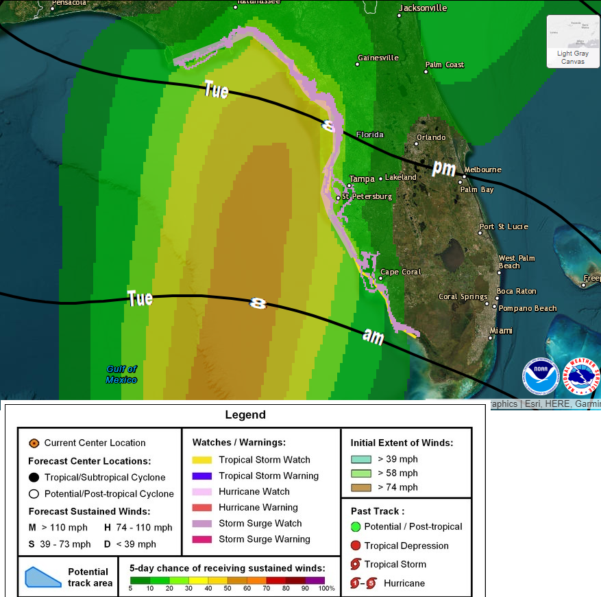
Indeed, the biggest change this evening is that we now have a broad swath of the Florida coast under Hurricane Watches and Storm Surge Watches.
Storm Surge Watch: Indian Pass on the Panhandle south to Chokoloskee on the southwest coast.
Hurricane Watch: Indian Pass south to Englewood, between Sarasota and Fort Myers
Tropical Storm Watch: Englewood south to Chokoloskee and for the Dry Tortugas.
On the map below I have overlaid the watches for Florida, in addition to the probability of 60 mph winds and the most likely arrival time of those tropical storm force winds. You can see how wide the berth is for potential strong wind.
The storm surge forecast from the NHC is somewhat aggressive, and it seems warranted given Idalia’s current forecast intensity. The map below shows the reasonable maximum surge above ground level in the impacted areas.
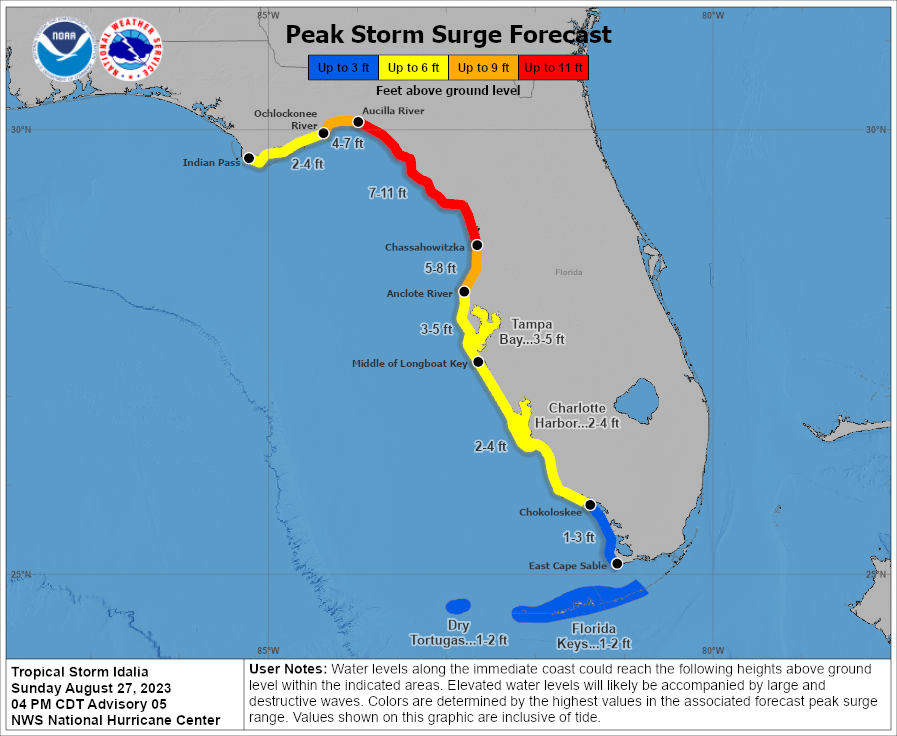
One important note: During Irma and last year during Ian, because of the wind direction, surge was directed out of Tampa Bay. With Idalia currently forecast to pass west and north of Tampa, this would direct surge *into* Tampa Bay. So please don’t go storm chasing this to see a dry Tampa Bay. Another important note: As Idalia’s forecast is revised, this forecast will be revised too, and you should be following forecast progress closely. Florida’s geography and the unique interaction with storms coming from this direction can lead to some substantial forecast impact changes with surge in particular.
So, for folks along Florida’s west coast, the Big Bend, and parts of the eastern Panhandle: You will need to be ready for potential hurricane impacts, regardless of exactly where Idalia comes ashore.
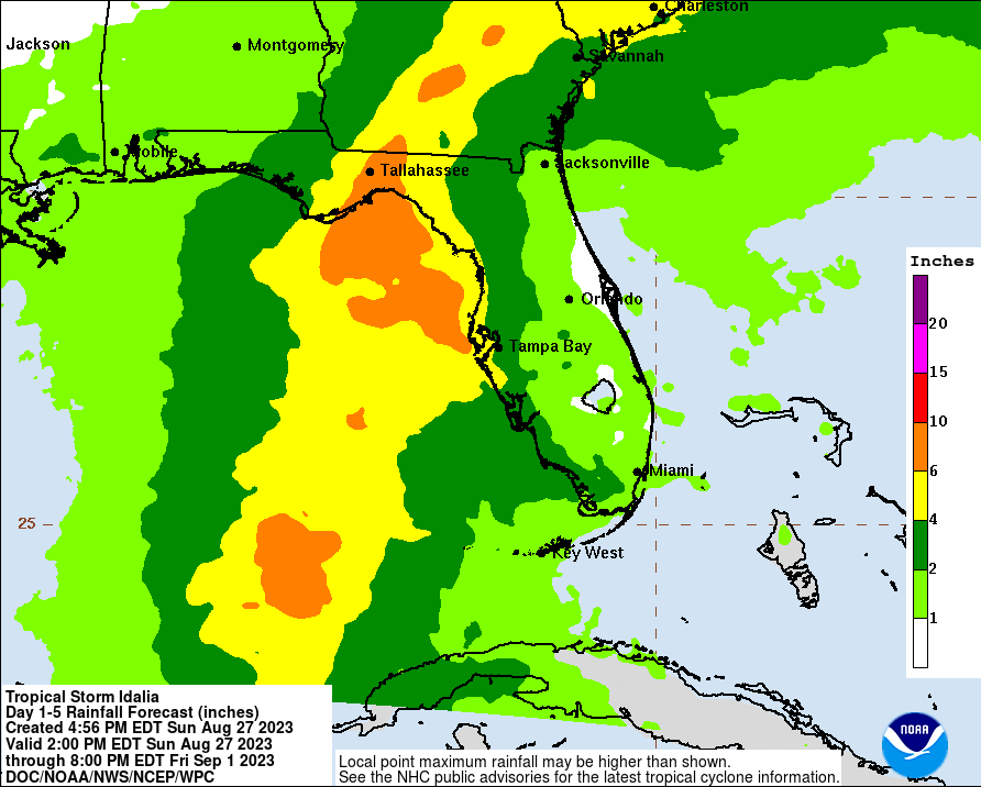
The rainfall forecast has not changed a ton. Idalia keeps moving at a good clip once it gets north of Florida. While this will by no means prevent flooding in spots, it does help to probably limit flooding concerns a bit. We’ll watch the situation in Carolinas a bit closely, as some heavy rain will front run Idalia today and tomorrow, and flood watches are already posted in eastern North Carolina. If I were watching some place closely for flooding risk, it would be there right now.
So, to summarize:
We will have our next update for you as usual on Monday morning.
Tropical Depression 10 continues to slowly organize off the Yucatan, and it continues to look to come north as a hurricane, impacting somewhere in Florida by Tuesday night.
Editor’s Note: Tropical Depression 10 was upgraded to Tropical Storm Idalia immediately after pressing “Publish.” While the content is unchanged, “TD 10” should now be referred to as Idalia.
One look at TD 10 this morning on satellite allows for two thoughts for me as a meteorologist. First, where is the center? Second, that’s a *lot* of thunderstorms.
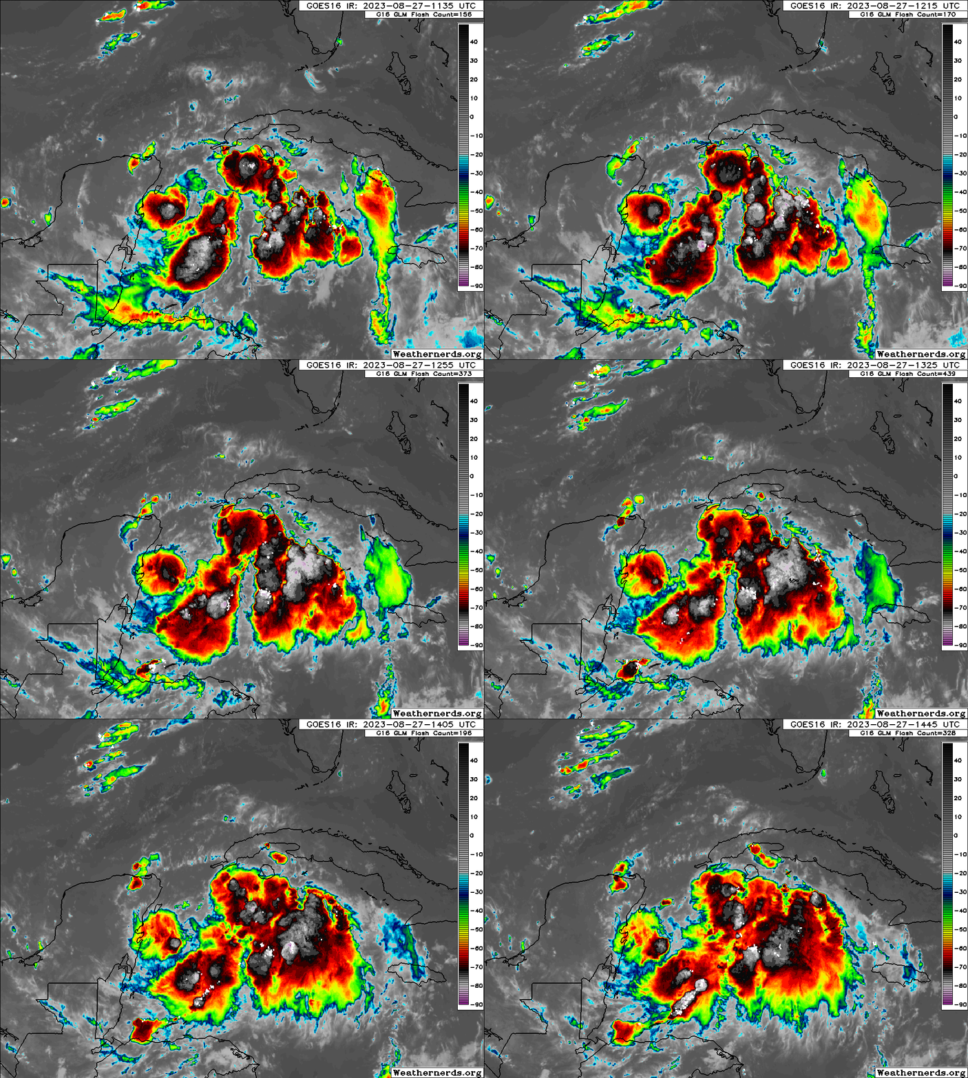
In terms of the first point, the center seems to be located near Cozumel. The NHC just placed the center about 75 miles ESE of Cozumel. It’s been doing a bit of a loop, but it remains in tact at least. TD 10 is expected to drift north over the next 24 hours, slowly organizing as it does so. We could have a tropical storm by later today or tomorrow.
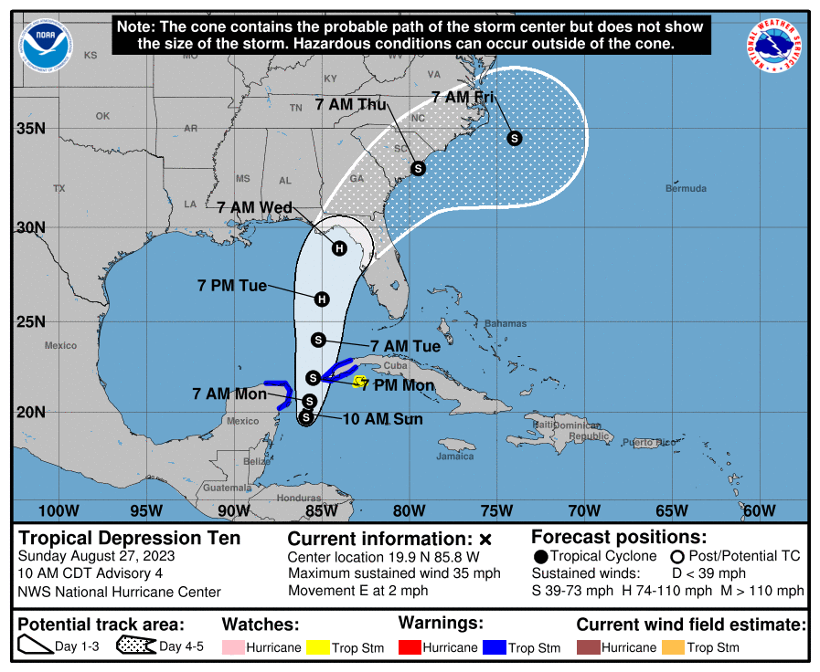
Thereafter, steering currents should direct this north/north-northeast toward the Florida coast. There are two important changes today in terms of track outlook that may not be obvious from the NHC outlook. First, the organization of TD 10 is still an issue. Until this thing can really wrap up and get going, there is some risk that the center tries to “reach” for the thunderstorms, which is to say, it’s entirely possible the center relocates at some point today. Second, model consensus on TD 10’s future track has shifted a little to the right (or east) since yesterday. This keeps the west coast, especially north of Tampa along the Nature Coast in play, as well as the Big Bend and Panhandle. Basically, everyone from about Destin to Sarasota should continue monitoring TD 10’s progress closely.
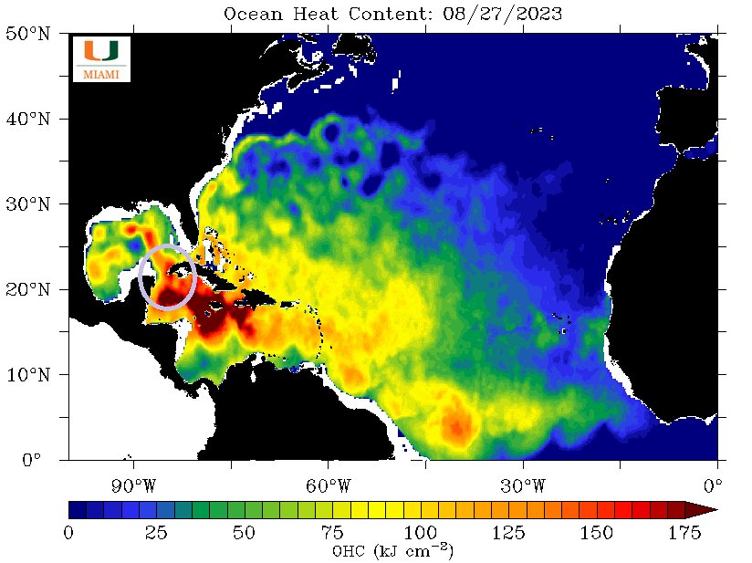
The reason you may be hearing a lot about TD 10 and its future is because of where it’s located. It’s over deep, rich warm water, an untapped resource it can probably tap into as it organizes. If and when that happens, TD 10 could quickly go from funky to formidable. And it remains likely that portions of the Florida coast will be dealing with hurricane impacts by Tuesday night. The NHC forecast brings maximum winds to 90 mph as TD 10 (then Idalia) comes ashore. It’s possible it could be stronger than that. In addition to wind, storm surge will probably be an issue as well as this storm comes ashore. The West Coast of Florida will need to watch this, as well as the Big Bend area, where surge could be maximized depending on the exact track of the storm.
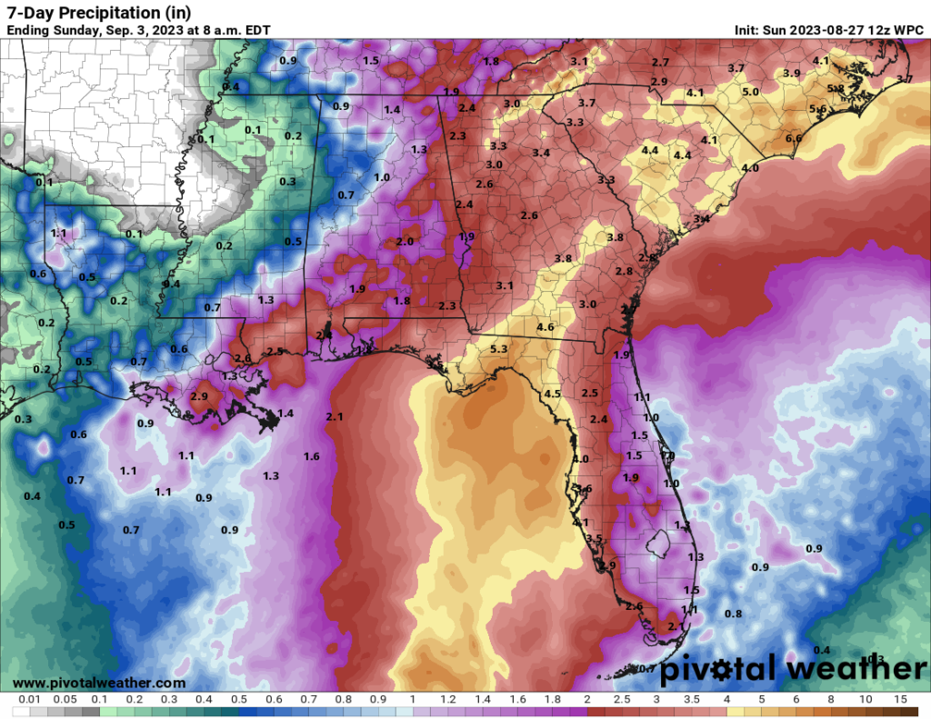
In addition to wind and surge, there is always the rainfall. A general 3 to 6 inches is likely along TD 10’s track as it comes north. Areas to the east of the track may also see some enhanced rain. Higher amounts are likely in spots and the potential for inland freshwater flooding is possible for Florida into Georgia and the Carolinas.
Bottom line on TD 10:
Our next update on TD 10 will be Monday morning, unless things change or become sharply clearer later today.
Meanwhile, in the Atlantic, Franklin had become a bit of a curiosity and afterthought yesterday as it looked to pass west of Bermuda as a hurricane. That has since changed some.
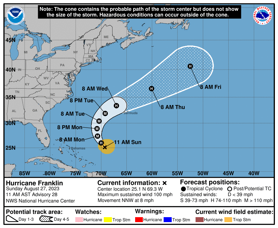
While Franklin should still miss Bermuda comfortably to the northwest, it may be large enough to produce fringe impacts on the island, including gusty winds and heavy rain, in addition to rough surf, rip tides, and beach erosion (something we may also see on the U.S. East Coast later this week). Franklin is forecast to peak in intensity before passing Bermuda, but still a decent, large-sized hurricane passing 100 to 150 miles away is capable of producing some impacts. Folks in Bermuda will want to monitor Franklin’s progress closely. For Newfoundland, this should mean fewer impacts ultimately.
Good afternoon. As expected, it’s an absolute burner out there today. Houston’s official weather station at Bush Intercontinental Airport has already reached 108 degrees as of 4 pm CT, which is 1 degree short of the city’s all-time heat record of 109 degrees. (We matched that record high on Thursday, you may recall). It’s now a race between temperatures and approaching rain showers.
In Friday’s forecast we mentioned the possibility of some late afternoon showers and thunderstorms developing on Sunday, associated with a weak boundary. We are now starting to see those showers forming north of the Houston metro area, and they should gradually move southward into the region throughout the evening hours. Areas where precipitation falls will see drops in temperature associated with rain-cooled air.
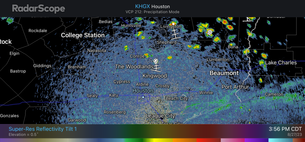
To set expectations, these showers will be very hit or miss. Lucky locations will pick up a few, quick tenths of an inch of rain, whereas other observers will look longingly as the dark clouds and see little, if any precipitation. At this point it looks like the stronger storms are more likely to develop north of Interstate 10, but areas all the way down to the coast at least have a puncher’s chance of seeing some shower activity.
We are entering a brief period where rain will be possible, essentially this evening through Tuesday morning, before a weak front brings some drier air and shuts the door on rain chances for awhile. We’ll have the full story on the forecast ahead in our post on Monday morning, but just wanted to jump in on a Sunday afternoon with a heads up about the rain chances this evening. Good luck out there!

Hovertext:
The total effacement of selfhood is bad but the corn is *very* sweet.
Invest 93L was upgraded to Tropical Depression 10 this afternoon, and it is likely to impact the west coast or Panhandle of Florida as a hurricane on Tuesday or Wednesday.
As of Saturday evening, Tropical Depression 10 was spinning in or just south of the Yucatan Channel and off the coast of the Yucatan.

TD 10 has a well defined center it appears and a pretty healthy circulation about it as it spins, mostly in place due to the absence of any real steering currents in this area. Heavy thunderstorms are displaced well east of the center over western Cuba and the Isle of Youth.
At present, we have tropical storm warnings from Rio Lagartos through Cancun and Cozumel south to Tulum on the Yucatan, and there are tropical storm watches in effect for the Isle of Youth and Pinar del Rio in Cuba. Warnings mean tropical storm conditions are likely, while watches mean they are possible. We are still a day or so away from watches being issued in Florida I believe.
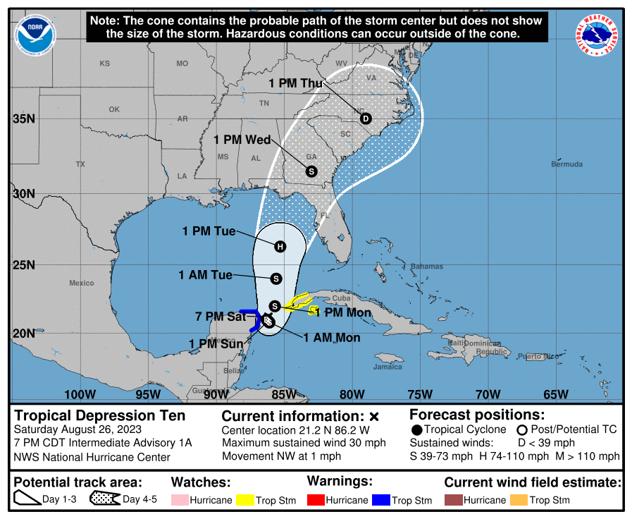
Tropical Depression 10 will stay in place much of tomorrow before drifting northward on Monday and then picking up the pace Tuesday. Broadly, it still is expected to track toward Florida, be it the Panhandle or the west coast. Modeling is focused on this tracking close to the NHC map above, near the Big Bend of Florida. However, given that there is a bit of uncertainty in terms of how the center behaves in the next day or two, everyone from the Alabama coast through the Keys and Cuba should be monitoring Tropical Depression 10’s progress. The next name on the list is Idalia.
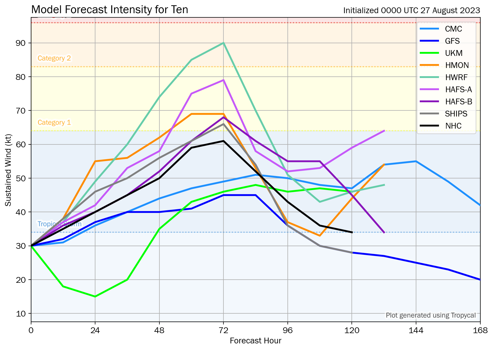
In terms of intensity, the NHC forecast above explicitly shows a 75 mph category 1 storm heading into the Panhandle or Big Bend. However, there is reason to believe that modeling and forecasts may be somewhat underdone. Water temperatures along the path of TD 10 will be very, very warm and that warm water is very deep as well, so this will have much fuel to feed off of. If wind shear or dry air get involved, this could limit the storm’s intensity some, but probably not entirely. Land interaction is also a wild card over the next day or so near the Yucatan, so the intensity forecast is a bit uncertain. I would anticipate at least a low-end hurricane, however, on the Florida coast by Tuesday night or Wednesday morning.
In addition to tropical impacts on the Florida coast, this is looking like a healthy rainmaker for Florida and the Southeast. Anywhere from 4 to 6 inches of rain are possible along and to the east of the path of TD 10 in Florida, and higher amounts are likely in some places depending on exactly how things play out. The rainfall distribution may change some once the storm ends up in the Southeast, with a widespread heavy rain possible, if not likely for parts of Georgia and the Carolinas. Details on this will get ironed out in the coming days.
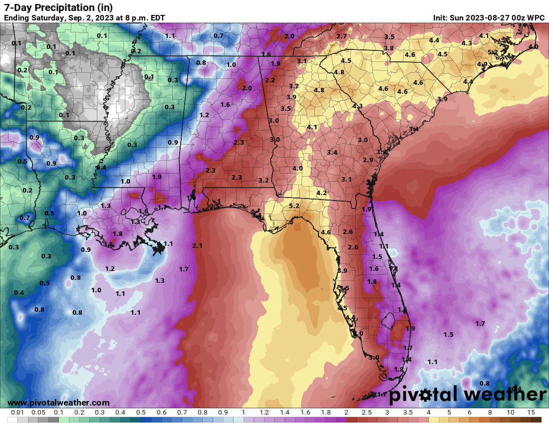
Again, like much of everything regarding TD 10, you can anticipate forecast changes to the above map.
The bottom line:
We will have another update on Tropical Depression 10 and the rest of the tropics by about midday Eastern time on Sunday.

For 35 years, Barker was a familiar presence in the living rooms of everyone from little old ladies, to kids home sick from school. He used his fame to promote another great passion: animal rights.
(Image credit: Amanda Edwards/Getty Images)


Fairly recently (May, 2023) there has been made available for sale a retro-themed laptop called the Book 8088. The Book 8088 is a real PC running a fair amount of vintage hardware and was made in China by a company called DZT. Additionally this company has also made a portable PC called the Hand 386. However, the Book 8088 is also the subject of controversy and reviews have been mixed on both products. Although I do not own either and have no intention to buy either I have researched and viewed enough YouTube reviews of the device to offer some relevant insights on these devices.
Read more »
Hovertext:
I wonder if this is the source of the protestant work ethic?
narf

At an evening vigil near the Dollar General store where the attack occurred, Florida Gov. Ron DeSantis was met with boos from the crowd as he stepped to the microphone.
(Image credit: John Raoux/AP)