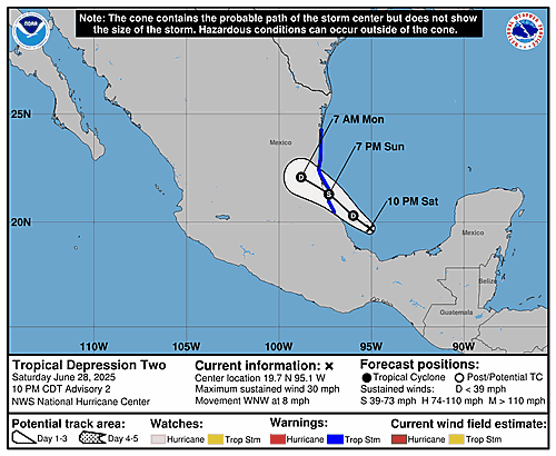
...HEAVY RAINS BEGINNING TO SPREAD ACROSS PORTIONS OF EASTERN MEXICO... As of 4:00 AM CDT Sun Jun 29 the center of Two was located near 19.9, -95.9 with movement WNW at 9 mph. The minimum central pressure was 1010 mb with maximum sustained winds of about 35 mph.
By default, apps on the App Store are provided Store Services Tier
2, the complete suite of all capabilities designed to maximize
visibility, engagement, growth, and operational efficiency.
Developers with apps on the App Store in the EU that
communicate and promote offers for digital goods and services can
choose to move their apps to only use Store Services Tier 1 and
pay a reduced store services fee.
What follows is a long chart, making clear which features are excluded from Tier 1.
Like I wrote in my larger piece on Apple’s new DMA compliance plans, I don’t think Tier 1 is intended to be a feasible choice for any mainstream apps or games. The whole thing is just a way to assert that 8 percent of the commission developers pay is justified by various features of the App Store itself.
MENLO PARK, CA – In a recent statement to shareholders, Meta CEO Mark Zuckerberg explained that the average American only had three in-person friendships, and that Facebook plans to reduce that number as soon as possible. “Most Americans can only count on three other real life people as true friends, which seems high to me,” […]
In brief: Invest 91L in the Bay of Campeche may develop into a depression, but it probably won’t get much farther than that. Invest 95E in the Pacific is likely to become the next tropical storm or hurricane there tracking up and off the coast of Mexico. Both will bring heavy rain to either coast of Mexico. Plus, we have the latest on the loss of microwave satellite imagery.
Invest 91L
We have our second “invest” of the season. Just to refresh people’s memories, “invests” are just when meteorologists at the National Hurricane Center tag areas of investigation. It’s mostly meant so we can start running some tropical models on a particular area. It doesn’t mean a storm will or won’t develop. It’s just a nice way to classify these things in the pre-storm phase.
Anyway, Invest 91L got tagged late yesterday, and today it’s emerging as expected into the Bay of Campeche.
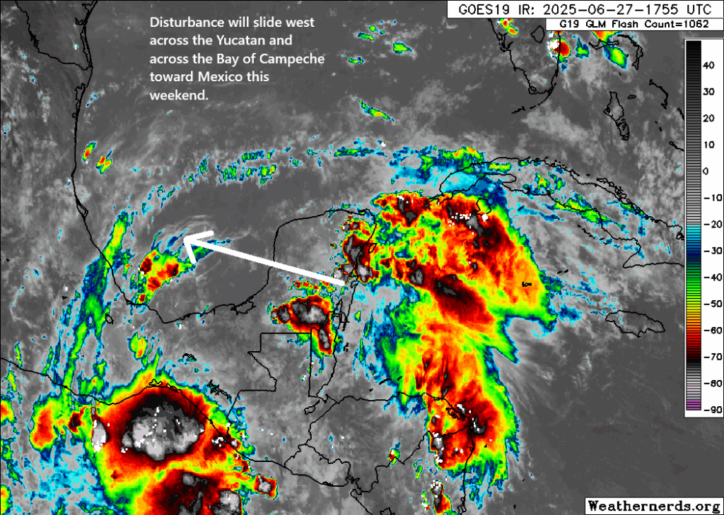
Invest 91L is dealing with some issues with thunderstorm development today. (Weathernerds.org)
Truthfully, it looked better yesterday, but after traversing the Yucatan, it should not be too surprising to see it struggling a bit. It’s also not as if wind shear is zero here either. There’s a fair bit of it still, which could limit its chances of becoming a depression or named storm. This is a case where the impacts are a lot clearer than the technical definition of the thing.
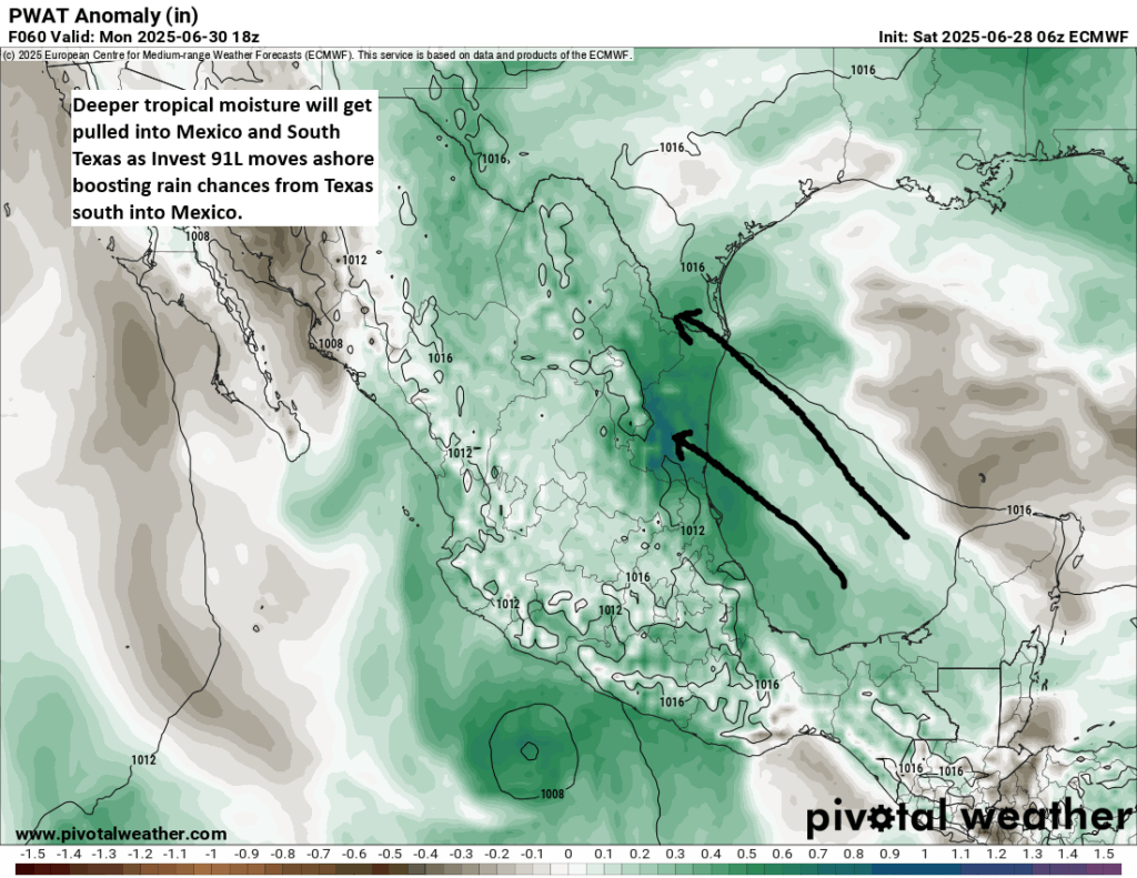
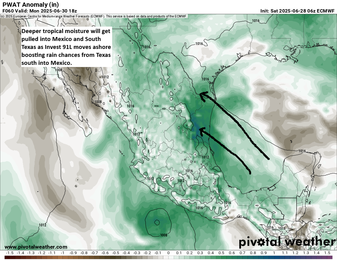
Indeed, those impacts will include some rough seas in the western Gulf, as well as heavy rainfall. Deep tropical moisture is going to get yanked north and west as 91L moves inland over Mexico tomorrow night and Monday.
Tropical moisture will boost locally heavy rain and flooding chances from Texas into Mexico. (Pivotal Weather)
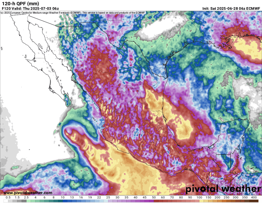
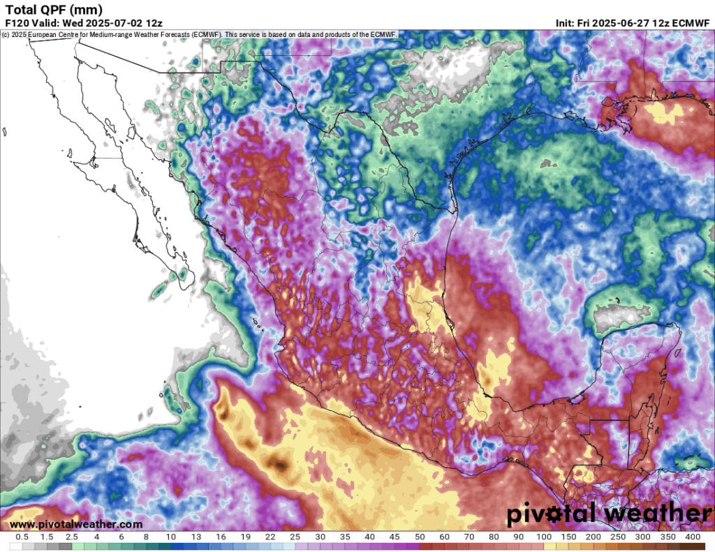
Rainfall is forecast to add up to 4 to 8 inches (100-200 mm) in parts of Mexico, with lower amounts in Texas over the next 5 days. That said, even up in Texas, there will almost certainly be locally heavier rainfall totals that show up, especially from Matagorda Bay south through Corpus and Brownsville.
Rain totals of 100-200 mm expected over the next 5 days in Mexico. (Pivotal Weather)
So the main concern from Invest 91L will clearly be heavy rain and flooding potential, particularly in Mexico. High pressure should build in later this week behind 91L to dry things out a bit.
Invest 95E a west coast of Mexico concern
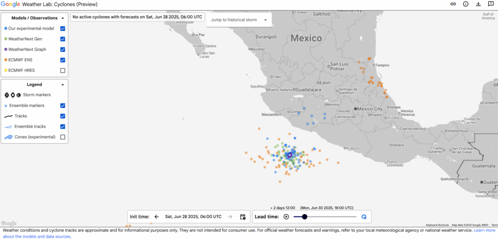
Meanwhile, in the Pacific, we have Invest 95E, which will be a rather interesting system for Mexico’s west coast. It should take a track up along the coast but offshore. However, this will likely expose much of the coast from Zihuatanejo north to Baja to tropical impacts as the system develops. And some modeling is actually rather robust with the intensity forecast of 95E.
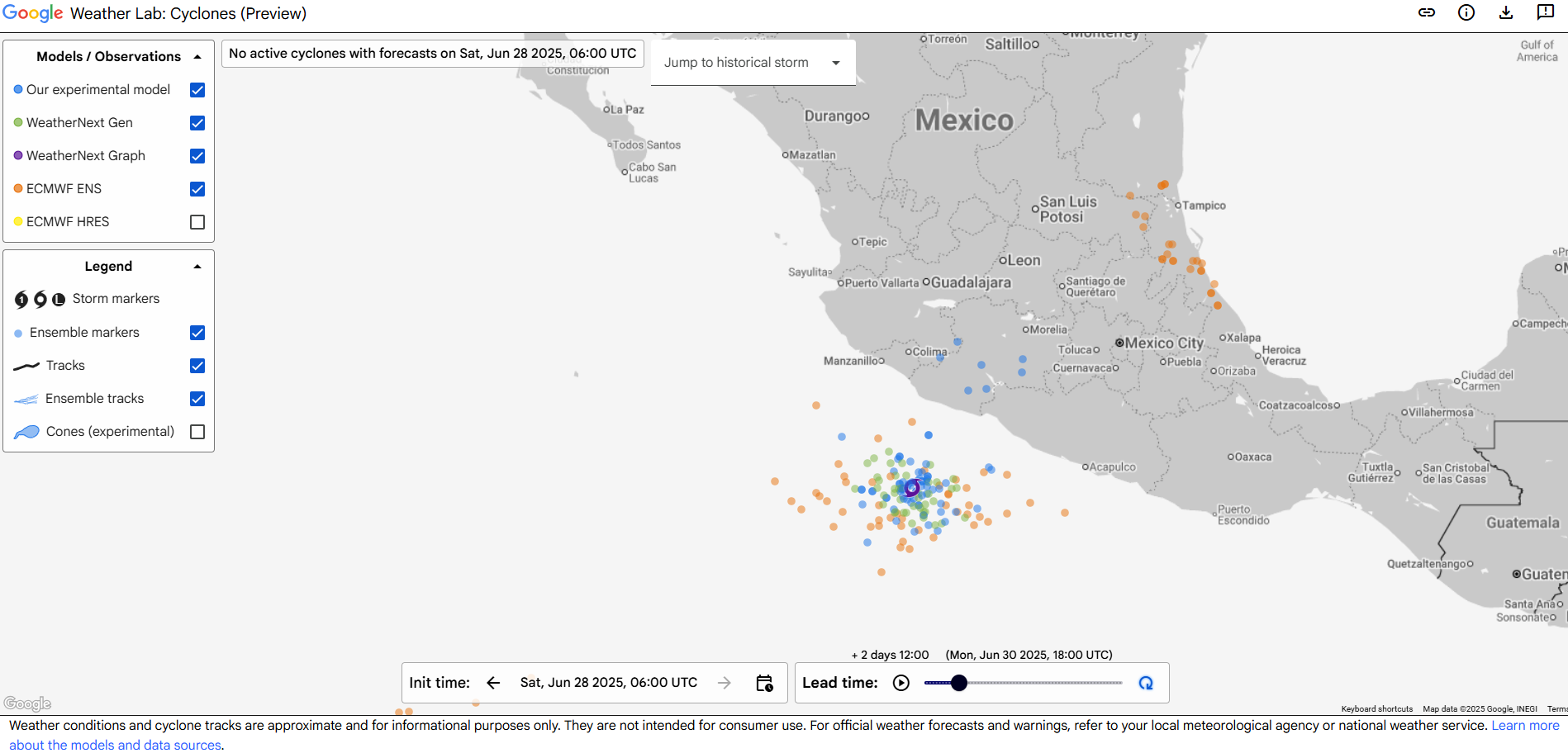
Google Weather Lab’s screenshot of their various AI model and European ensemble forecast positions of Invest 95E valid on Monday afternoon. (Google)
It should be far enough offshore to keep the worst impacts out at sea, but there are certainly a handful of model solutions that bring this close enough to the coast to produce consequential impacts. You can see from the rainfall map above under the section about Invest 91L that even the west coast of Mexico will see substantial rain over the next 5 days as a result. By the time this does reach Baja and Cabo, it should be weakening under the influence of much colder water. So hurricane impacts are not expected that far north, but locally heavy rain will be a concern. Some of that remnant moisture could get pulled into the Desert Southwest by about next weekend and help enhance monsoon thunderstorms a bit.
Elsewhere
Nothing new to report today elsewhere, including next weekend’s potential in the northeast Gulf or southwest Atlantic, which looks no scarier or likelier today.
Regarding yesterday’s post about the cuts to microwave satellite imagery, which sparked some spirited comments, please keep in mind that nothing about the post was politically motivated or biased. The actual fact of the matter is that we are living in a new reality that did not exist a year ago in the weather community (wide NWS cuts, wide reduction in weather balloon launches, budget requests to eliminate departments that serve the broader weather community, and more), and it’s incumbent on us to make sure people are aware of what is happening based on the facts, which we laid out yesterday.
In brief: A system moving toward the Bay of Campeche has about a 30 percent chance of developing before it moves ashore in Mexico later Sunday or Monday. Another system in the northeast Gulf may emerge by late next week with low odds of developing a little. Plus, we answer questions surrounding the expected loss of a major satellite tool used in hurricane forecasting.
Bay of Campeche
There is a disturbance sitting off the Yucatan as of Friday morning. This is expected to cross the Yucatan and emerge into the Bay of Campeche this weekend. From there it should continue to press west or west northwest into Mexico. Does it have a chance to develop? Certainly; the National Hurricane Center currently assigns about 20 percent odds of it doing so.
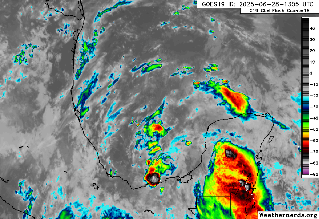
An early afternoon satellite image of the disturbance approaching the Yucatan shows little to no organization but plenty of thunderstorm activity. (Weathernerds.org)
However, realistically, this has such a limited time over water with minimal organization that even if something began organizing, it would run into the wall that is mainland Mexico by Sunday or Monday. Thus, any development is both low and with a low ceiling for intensity. That said, this disturbance will bring some heavy rain to Mexico this weekend and early next week.
Five-day rain totals in eastern Mexico tally up to over 100 mm of rain (~4 inches)
But in terms of concern priorities, it’s low.
Northeast Gulf late next week
We continue to see signs in modeling that another disturbance will emerge in the northeastern Gulf by later next week.
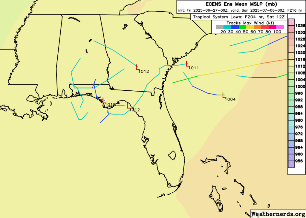
The system will pinch off of a dying cold front that stalls out in the northeast Gulf and off the Southeast coast. Look for unsettled weather to setup in the northeast Gulf by late next week, likely bringing some continued heavy rain risk to parts of Florida and the Gulf Coast. But will it develop beyond just periodic thunderstorms? It’s too soon to say, but there is a subset of weather modeling that points to this.
A handful of the 51 European ensemble members show a tropical system of generally low intensity near the northeast Gulf or off the Southeast coast next weekend. (Weathernerds.org)
This is not what I’d call “strong agreement,” but it’s something I suppose. I think the most likely outcome here is that we get a disturbance that festers for a few days off the west coast of Florida or even over Florida itself and then gradually exits out to sea. Development odds seem fairly low overall, and I would presume that overall conditions would be hostile for significant organization.
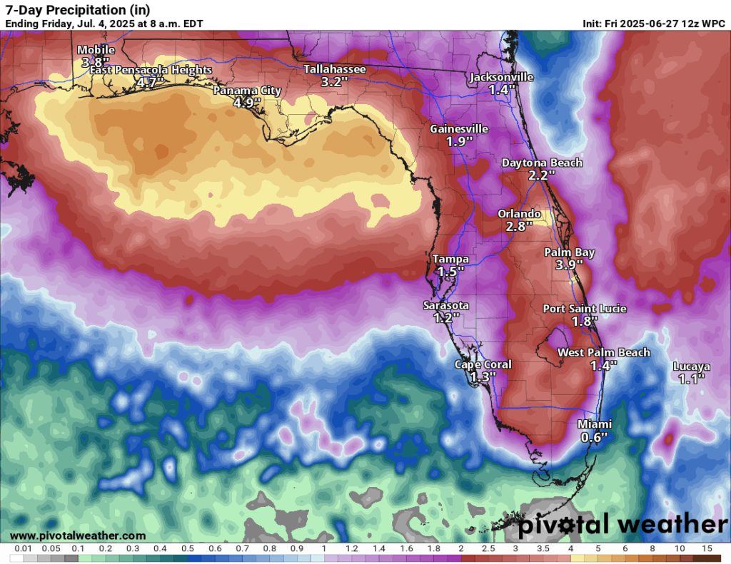
The heavy rain risk later next week is noteworthy with several inches of rain possible in Florida, especially along the coast between Pensacola and Tampa. This could lead to some eventual flash flooding issues there.
Rainfall forecast for Florida through July 4th morning. (Pivotal Weather)
Meanwhile, let me tell you what I know and what I think this means. I’ll caveat this by saying that this administration has a well-documented habit of making rash decisions, triggering outrage, and then either pulling back the decision or changing it in some way to make it more palatable overall. So what I write here may be outdated literally 5 minutes from now. If they’re trying to build massive frustration, chaos, and increase unpredictability, they’re being quite successful. That said, since this situation seems to start at DoD, I don’t believe we’re going to have a positive resolution.
What is this satellite data?
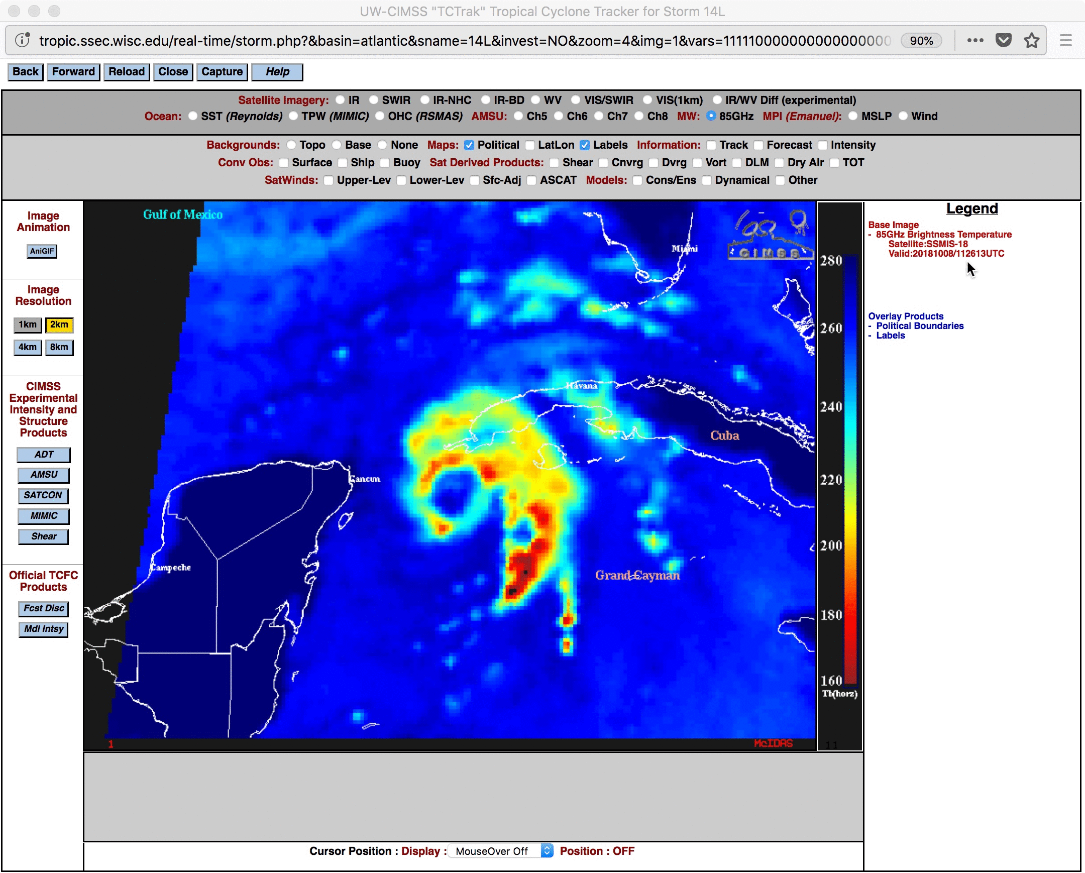
The Department of Defense has 3 satellites in space that provide a bunch of weather monitoring and space weather data. One of the most important is the Special Sensor Microwave Imager Sounder (SSMIS). The SSMIS data is a key component in hurricane forecasting, as it allows forecasters to observe the features of a tropical system that cannot be adequately viewed on regular weather satellites. Take for example the below image I am borrowing from the University of Wisconsin.
Tropical Storm Michael (2018) comparison using regular weather satellite and the microwave SSMIS data. (University of Wisconsin)
Notice how on traditional weather satellite, Michael looks like a very active storm with numerous thunderstorms. But in the “bluer” image, you can actually see an eye forming underneath the thunderstorms. Michael eventually hit the Florida Panhandle as a category 5 hurricane. This is a nice precursor for a meteorologist to get a view on to help inform forecasting or intensity estimates of a storm. In fact, it’s arguably critical information to have to help predict or identify that a storm is rapidly intensifying. It also helps us peg down the center of a storm when you don’t have aircraft out observing it. We sometimes take hurricane hunters for granted, as they’re not in every single storm. It’s tools like this that have been developed that fill the gap.
What is happening?
The DoD has announced that as of Monday this data will no longer be available to anyone.
But, surely the National Hurricane Center will retain access, right?
As far as I am aware and what is being reported in the media, the NHC does not have an exemption from this order. And this data will no longer be available for anyone outside of DoD. That may or may not be the case, but no one has said anything to this point to assume so one way or another.
What will losing this mean for forecasts?
Right out of the gate, if we have this data missing, you can expect a few things.
First, particularly for storms that are early in their development cycle, you will have a less accurate position of the center of the storm. Why does this matter? Because that’s what gets fed into every single model we use to forecast.
Second, when a storm is rapidly intensifying, we may get a delayed reaction. In other words, it may be 3 or 4 more hours after it begins that we’re able to identify that it has begun. Why does this matter? First off, situational awareness of what’s happening. Delaying that is poor. But of more importance, again, you are feeding models this data. Garbage in, garbage out. If you input a less accurate picture of intensity, you’re more likely to get an inaccurate intensity *and* track forecast. Intensity impacts track.
Third, the ripple effect of all this means less accurate forecasts at scale: Poorer NHC forecasts, poorer model forecasts (including from the European, ICON, Canadian, etc. models), potentially less warning that a storm is coming at a level that requires evacuation decisions. That’s not an exaggeration either.
Can we replace it with other data?
There are other microwave sensors on other satellites outside of DoD that we can use to fill some gaps. However, as Lowry reported in the link above, the DoD sensors comprise half of all microwave sounding data. So basically, while there is still a lot of data available, you are taking one critical data set and slicing it in half. Basically, you’re setting hurricane forecasting backwards.
So why is the DoD doing this?
The official reasoning is security. No specifics have been given. There was no head’s up. They just pushed out the memo above, and here we are today. In Matt’s opinion, it would have been nice for them to include disseminating the data to NOAA still. But perhaps whatever security issue is occurring affects that too. Who knows, but it would be nice to know from a public awareness and safety standpoint why we’re willfully degrading hurricane forecasting.
Bottom line: The government has decided that a key tool utilized by government and private sector meteorologists and researchers to track the intensity and position of tropical systems is going away on Monday with no actual reasoning and no replacement identified. While the public affairs folks will say they still have robust and significant data available to NOAA and the public, the reality is that one of the most important tools in the arsenal will no longer be there every time we need it to be.
Melanie Lawson returned to the ABC13 KTRK Houston anchor desk this week after being gone for more than a year.And with her return, Lawson talked with Briana Conner about her relationship with Beyoncé and the Knowles family through the decades ahead of this weekend's Cowboy Carter tour at NRG.- Beyoncé's early days remembered by Houston TV- Beyoncé interviewed with Kelly
Nearly 150 people were jabbed with syringes during a street music festival in France, with authorities having arrested at least 12 suspects. What do you think?
“This was bound to happen in a country overrun by free healthcare.”
LOS ANGELES—Coinciding with a spike in interest in cars and moving fast, a trend report published Friday by Edmunds Research confirmed that driving was surging in popularity thanks to Apple’s new film F1. “F1 has really pushed driving into the forefront of culture, and now it’s having a moment,” said report co-author Jared Eash, who noted that millions of the film’s fans across the country were crowding into car dealerships and heading out onto streets and roads in an effort to try out the motor vehicle trend for themselves. “Personally, I love getting into my Nissan Sentra and driving around Kansas City. I feel just like Brad Pitt! And I know I’m not alone. There are some superfans who say that thanks to the movie, they operate a car every day, or even multiple times a day. F1 has officially put cars on the map.” At press time, the popularity of driving was reportedly waning after those trying it for the first time learned about stop signs.
KELOWNA, BC – An empanelled jury hearing the murder trial of Dr. Kenneth Pritchard has expressed bitter disappointment after hearing that the defendant was accused of killing his victim with a dumb ol’ gun. “At first, I was so stoked to be picked to sit on a murder trial, and even more so once I […]
WASHINGTON, DC – U.S. President Donald Trump has publicly announced that he will cease all discussions with Canada over any new trade agreements, before immediately following that up stating that discussions have resumed despite never having stopped. Moments later, Trump took to social media specifically to denounce and formally end the discussions while pondering which […]
The vaccine panel hand-selected by health secretary and
anti-vaccine advocate Robert F. Kennedy Jr. on Thursday voted
overwhelmingly to drop federal recommendations for seasonal flu
shots that contain the ethyl-mercury containing preservative
thimerosal. The panel did so after hearing a misleading and
cherry-picked presentation from an anti-vaccine activist.
There is extensive data from the last quarter century proving that
the antiseptic preservative is safe, with no harms identified
beyond slight soreness at the injection site, but none of that
data was presented during today’s meeting.
The significance of the vote is unclear for now. The vast majority
of seasonal influenza vaccines currently used in the US — about
96 percent of flu shots in 2024–2025 — do not contain thimerosal.
The preservative is only included in multi-dose vials of seasonal
flu vaccines, where it prevents the growth of bacteria and fungi
potentially introduced as doses are withdrawn.
However, thimerosal is more common elsewhere in the world for
various multi-dose vaccine vials, which are cheaper than the
single-dose vials more commonly used in the US. If other countries
follow the US’s lead and abandon thimerosal, it could increase the
cost of vaccines in other countries and, in turn, lead to fewer
vaccinations.
Having an ignorant conspiracy nut lead the Department of Health and Human Services is angering and worrisome, to say the least. But it’s also incredibly frustrating, because Donald Trump himself isn’t an anti-vaxxer. In fact, one of the few great achievements of the first Trump Administration was Operation Warp Speed, a highly successful effort spearheaded by the US federal government to “facilitate and accelerate the development, manufacturing, and distribution of COVID-19 vaccines, therapeutics, and diagnostics.” Early in the pandemic experts were concerned it would take years before a Covid vaccine might be available. Instead, multiple effective vaccines were widely available — and administered free of charge — in the first half of 2021, only a year after the pandemic broke. It was a remarkable success and any other president who spearheaded Operation Warp Speed would have rightfully taken tremendous credit for it.
But instead, while plotting his return to office, Trump smelled opportunity with the anti-vax contingent of the out-and-proud Stupid-Americans, and now here we are, with a genuine know-nothing lunatic like RFK Jr. as Secretary of Health and Human Services. God help us if another pandemic hits in the next few years.
The company has promoted its Brad Pitt racing film with
advertisements across at least six iPhone apps leading up to
today’s wide release, including the App Store, Apple Wallet,
Apple Sports, Apple Podcasts, iTunes Store, and of course the
Apple TV app.
Most of those apps have ads in them all the time. It’s certainly fine for Apple to use those ad spots to promote their own movie. Even with Apple Sports, which most of the time has no ads at all, I think it’s fine for Apple to occasionally drop a promotion in there for something of their own. And F1 The Movie is a sports movie. The Apple Wallet push notification isn’t just a little different, it’s a lot different.
I will also note one other sort-of promotion. I play the mini crossword every morning in Apple News. Today’s 1-down clue was “F1 The Movie star Brad ____”. I think that’s a clever on-brand tie-in. Fun, not obnoxious. But with the smell of that Wallet push-notification fart still hanging in the air, not as much fun as it otherwise would have been.
The school sought to leave the church because of differences over gay marriage and clergy. The court did not decide whether SMU could be prevented from separating.
Hidalgo, a 34-year-old Democrat, was first elected in 2018 and then reelected in 2022. Other candidates have emerged for the 2026 election, including fellow Democrat Annise Parker, a former Houston mayor.
Millions of Americans will celebrate Independence Day with fireworks this year, though the legality of the explosives varies throughout the country. The Onion examines the pros and cons of banning fireworks.
PRO
Kites can take their rightful place as sovereigns of the sky
Medical fireworks still available through firework dispensaries
No reason to visit Indiana anymore
Mom’s new boyfriend will instead have to prove himself by eating really spicy pepper
CON
No way to find out which dogs would abandon you in a shootout
Far fewer loose fingers for birds to incorporate into nest
Billy’s Fireworks & Stuff can only sell so many vapes
No other reason to look up at the sky in wonder
Lose most effective way to quickly raze 4,000 acres of forestland
Yet another American tradition discarded for nothing more than safety, environmental hazards, animal welfare, and good taste
The vaccine panel hand-selected by health secretary and anti-vaccine advocate Robert F. Kennedy Jr. on Thursday voted overwhelmingly to drop federal recommendations for seasonal flu shots that contain the ethyl-mercury containing preservative thimerosal. The panel did so after hearing a misleading and cherry-picked presentation from an anti-vaccine activist.
There is extensive data from the last quarter century proving that the antiseptic preservative is safe, with no harms identified beyond slight soreness at the injection site, but none of that data was presented during today's meeting.
The significance of the vote is unclear for now. The vast majority of seasonal influenza vaccines currently used in the US—about 96 percent of flu shots in 2024–2025—do not contain thimerosal. The preservative is only included in multi-dose vials of seasonal flu vaccines, where it prevents the growth of bacteria and fungi potentially introduced as doses are withdrawn.
In a 6-3 decision, the Supreme Court held that age verification for explicit sites is constitutional. In a dissent, Justice Elena Kagan warned it burdens adults and ignores First Amendment precedent.
Edward “Big Balls” Coristine’s placement at the SSA comes after a White House official told WIRED on Tuesday that the 19-year-old had resigned from his position in government.


