Shared posts

04 Jun 16:53

The FDA says people are confusing poppers with energy shots, and dying. Experts want proof

by Nick Logan
Poppers Alkyl Nitrites

It’s not unusual for the packaging of one product to resemble that of another, potentially leading to mix-ups. But the U.S. Food and Drug Administration (FDA) has warned people who drink energy shots to make sure they’re not accidentally chugging a bottle of poppers — or they might end up sick or dead. 

04 Jun 16:49

How the far right tore apart one of the best tools to fight voter fraud

by Miles Parks
The Electronic Registration Information Center, or ERIC, has for years operated as a bipartisan success story in election administration. But since early 2022, the far right has targeted ERIC, fracturing a partnership that had 32 member states at its height. Eight states where Republicans oversee voting have so far pulled out.

A right-wing campaign has targeted a once-obscure voting partnership called ERIC. Eight Republican states have now pulled out, giving the election denial movement a big win — and a blueprint for 2024.

(Image credit: Glenn Harvey for NPR)

04 Jun 16:46

Saturday night surprise sets the stage for occasionally stormy weather through midweek

by Eric Berger

Good morning. Just jumping in here with a quick Sunday morning update. Yes, a line of fairly strong thunderstorms moved through the Houston area during the overnight hours. No, we did not anticipate them being quite so strong, or arriving quite so early. Sorry for the late-night wake-up call.

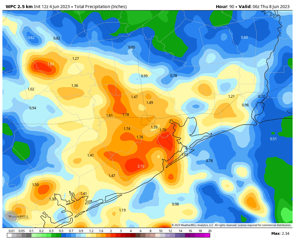
The good news is that the overnight storms sapped the atmosphere of much of its energy, and this should lessen thunderstorm activity today. I would expect mostly cloudy skies to prevail, with highs of about 90 degrees or just above, and moderate to high humidity. Your overall chances of seeing a shower or a thunderstorm this afternoon is probably about 30 percent. These rain chances will continue this evening, and during the overnight hours, but at this point I don’t see much sign of a similar flare-up of storms late tonight like the region experienced on Saturday night.

NOAA rain accumulation forecast for now through Wednesday. (Weather Bell)

With that being said, the overall pattern this week favors additional showers and thunderstorms through about Wednesday, as disturbances move down from the north into our region. I don’t have much confidence right now in whether these will occur during the daytime, along with atmospheric heating, or at nighttime. Rain chances will go down, and temperatures up, toward the end of the week.

More tomorrow.

04 Jun 16:43

System76's Open Firmware 'Re-Disables' Intel's Management Engine

by EditorDavid
Linux computer vendor System76 shared some news in a recent blog post. "We prefer to disable the Intel Management Engine wherever possible to reduce the amount of closed firmware running on System76 hardware. We've resolved a coreboot bug that allows the Intel ME (Management Engine) to once again be disabled." Phoronix reports that the move will "benefit their latest Intel Core 13th Gen 'Raptor Lake' wares as well as prior generation devices." Intel ME is disabled for their latest Raptor lake laptops and most older platforms with some exceptions like where having a silicon issue with Tiger Lake. System76 has also added a new firmware setup menu option for enabling/disabling UEFI Secure Boot. The motivation here with making it easier to toggle Secure Boot is for allowing Windows 11 support with SB active while running System76 Open Firmware.

Read more of this story at Slashdot.

04 Jun 13:53

AI Podcast 3.0: Dial M for Mechanization

It's the thrilling conclusion to our three-part series on AI — the world premiere of the first episode of Planet Money written by AI. In Part 1 of this series, we taught AI how to write an original Planet Money script by feeding it real research and interviews. In Part 2, we used AI to clone the voice of our former colleague Robert Smith.

Now, we've put everything together into a 15-minute Planet Money episode. And we've gathered some of our co-hosts to listen along.

So, how did the AI do? You'll have to listen to learn what went surprisingly well, where it fell short, and hear reactions from the real-life hosts whose jobs could be at risk of being replaced by the machines.

This episode was produced by Emma Peaslee and Willa Rubin. It was engineered by James Willetts and fact-checked by Sierra Juarez. Keith Romer edited this series and Jess Jiang is our acting executive producer.

In the radio play, Mary Childs voiced Ethel Kinney; Willa Rubin voiced Alice; and Kenny Malone voiced Dr. Jones and Dial Doom 5000.

Help support Planet Money and get bonus episodes by subscribing to Planet Money+
in Apple Podcasts or at plus.npr.org/planetmoney.

Learn more about sponsor message choices: podcastchoices.com/adchoices

NPR Privacy Policy
03 Jun 21:21

People Like Us: “Day Jobs” at the Blanton Museum of Art

by Barbara Purcell
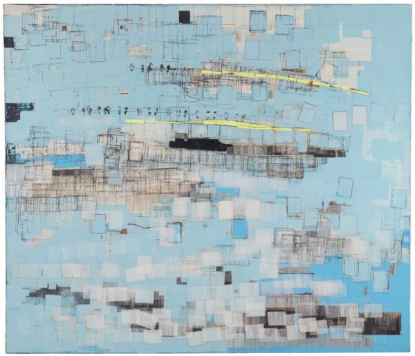
Blue mixed media painting on canvas

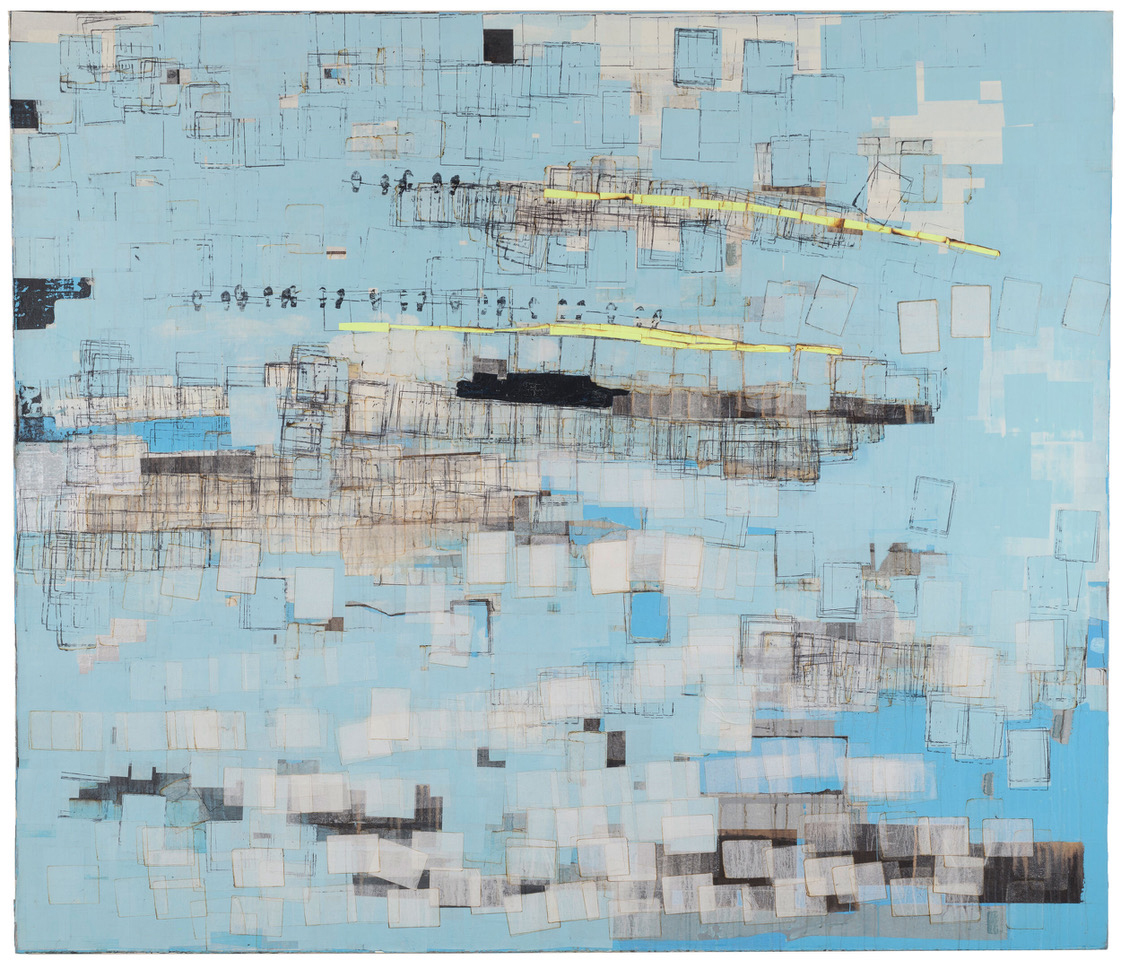
Mark Bradford, “Same ‘Ol Pimp,” 2002, mixed media on canvas, 72 x 84 inches, Collection of Barbara and Michael Gamson (photo: © Paul Hester/Hester + Hardaway Photographers)

An action-packed exhibition at the Blanton Museum of Art at the University of Texas at Austin spotlights nearly 100 works from 38 artists whose day jobs not only informed their art, but became their art. The lineup includes both emerging and established figures who moonlighted, side hustled — and even went corporate — all in a bid to pay the bills and grace the walls.

Organized by the Blanton’s former curator of modern and contemporary art, Veronica Roberts, and former curatorial assistant Lynne Maphies, the wide-ranging exhibition has been years in the making. Though Roberts knew from the outset certain artists would be included — former Condé Nast head designer turned conceptual collagist Barbara Kruger, for instance — others came through word of mouth from artist friends and fellow curators who shared numerous stories about rather intriguing, and often unassuming, paths to success. 

Mixed media painting of eyes, and lips

Tishan Hsu, “Portrait,” 1982, oil stick, enamel, acrylic, and vinyl cement compound on wood, 57 x 87 x 6 inches, Courtesy the artist and Miguel Abreu Gallery, New York (photo: © 2022 Tishan Hsu / Artists Rights Society (ARS), New York)

“The criteria had to be not that someone had a day job — every American artist has a day job — it was that the day job had a real influence on their practice and shaped their work in some pivotal way,” said Roberts at the show’s press preview.  

Day Jobs begins with an installation titled Piloto (Pilot) (2022) by Puerto Rican sculptor-inventor Manuel Alejandro Rodríguez-Delgado, showcasing an autobiographic, futuristic space pack created during his recent residency in Galveston. This is the first time Delgado’s work has appeared in a major museum exhibition and it speaks, quite literally, to the work it took to get here. After graduating from Escuela de Artes Plásticas in San Juan, the artist completed an MFA at the Art Institute of Chicago, taking a job as a crate maker to offset student costs. (A pair of crates, shown adjacent to the sculpture, were custom-made by Delgado to transport the work itself.) His battery-operated, thermo-controlled pack (complete with pandemic-proof breathing apparatus) contains a notebook brimming with notes — ideas for future works — years in the making, ready for takeoff.

Farther into the gallery, we see works by Robert Ryman, Dan Flavin, and Sol LeWitt — all of them had jobs early in life at the Museum of Modern Art in New York (MoMA) — with Flavin’s fluorescent “monument” for V. Tatlin (1969), a sort of spire-less skyscraper, soaking up much of the attention. Flavin, who worked as an elevator attendant at the museum, was allegedly fired for being a motormouth. Ryman, a jazz musician and security guard, was so taken with what he saw on the walls that he put down his saxophone and took up painting instead. 
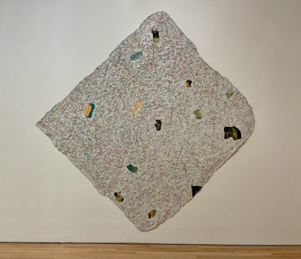
Mixed media work on paper

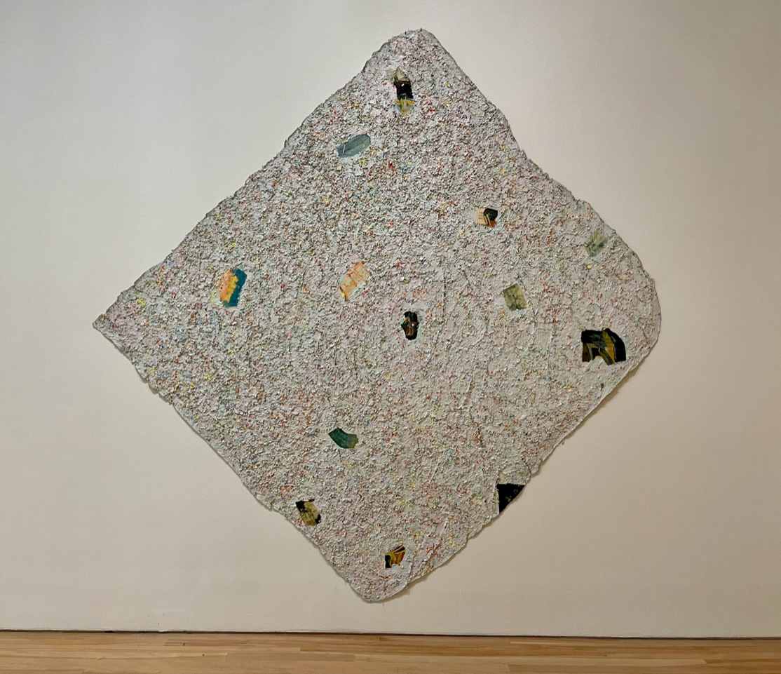
Howardena Pindell, “Autobiography: Japan (Mountain Reflection),” 1982-1983, acrylic, punched and cut paper, and threat on cut and sewn unstretched canvas, overall 107 x 106 3/4 inches, Collection of Timothy C. Headington. Photo: Barbara Purcell.

There is also an abstract work by painter (and MoMA staffer) Howardena Pindell, who trained as an oil painter at Yale but struggled to find success in the medium. So she used office supplies to hole-punch her way out of a long-time position at the museum. (Look closely at her work and you will see a cosmos of paper dots.) Later in the exhibition, a stainless steel bust of Louis XIV by Jeff Koons shines like a beacon of pop. Koons, who was a commodities broker before he made sculptures, worked at the museum’s membership desk when he first moved to New York. 

Though MoMA, as a right of passage, proves somewhat legendary in Day Jobs, the exhibition expands into six separate categories: “Art World,” “Service Industry,” “Media and Advertising,” “Fashion and Design,” “Caregivers,” and “Finance, Technology, and Law.” Certain jobs (like working at a museum!) might seem like the obvious choice for an aspiring artist, but as this show reveals, each industry spurred just the right epiphany for each artist and their practice — be it through materials, execution, or just plain old experience.   

Take Allan McCollum, a former airline food preparer, whose massive wall-sized installation, Surrogates (1983-1985), consists of 200 tray-like frames of various sizes and colors — mass-produced yet hand-painted — speaking to the commodification and intrinsic value of any given art object. And Tom Kiefer, a fine arts photographer who worked part-time as a janitor at a U.S. Customs and Border Protection processing facility in Arizona, whose photographs of artfully arranged objects confiscated from migrants are an aerial display of ethereal beauty. 
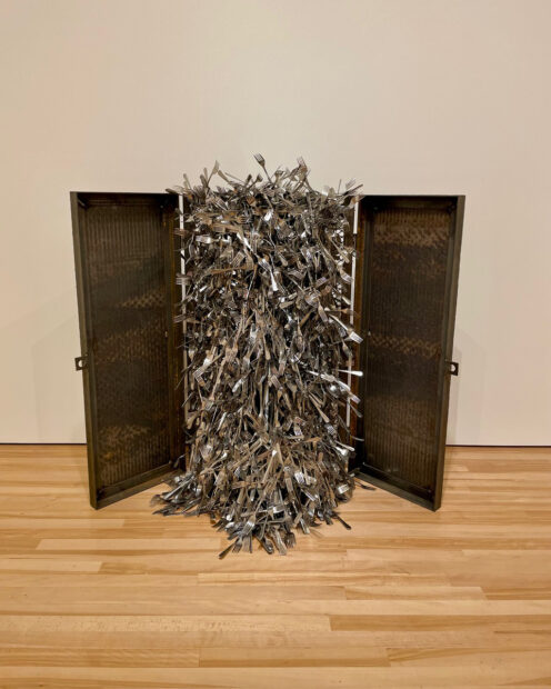
Sculpture of silver cutlery in a box

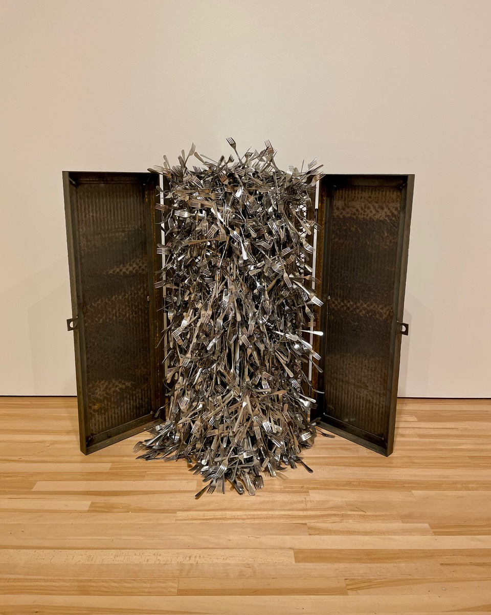
Violette Bule, “Homage to Johnny,” 2015, silverware, steel grate, and magnets, (approximate) 48 1/2 x 65 x 15 inches, Collection of the artist. Photo: Barbara Purcell.

There is also Venezuelan-born Violette Bule, who spent time working in New York City restaurants. Her sculpture, Homage to Johnny (2015), showcases a metal grate, like the ones flopped open on the city’s sidewalks that lead down into the dungeons of its eateries. Homage opens like a religious triptych; a dense concentration of forks, held together by strong magnets, which acknowledge the weight that a worker like Johnny, paid under the table, under the streets of New York, must wash away, one by one, in order to finish each day. 

Not to mention Bronx native Fred Wilson, who, as a kid, spent so much time in the city’s museums, he soon found himself working in them. Wilson’s installation Grey Area (Brown version) (1993) features five busts of the Ancient Egyptian queen Nefertiti, each a different shade of brown, ascending from light to dark, calling colorism, beauty, and provenance into question all at once. (The original is in a museum, not in Cairo, but Berlin.) 

Two abstract paintings by Mark Bradford incorporate end papers and hair dye — product essentials he used for years while working in his mother’s Black beauty shop in South Los Angeles. Tishan Hsu’s Portrait (1982) speaks to the ways in which technology cleaves us from our own bodies; at the time, Hsu worked the night shift as a word processor (pre-computers) at a law firm in Lower Manhattan. Jeffrey Gibson’s People Like Us (2018) depicts a ritual garment worn by Native Americans to ward off harm, and floats outstretched in the space like a dazzling window display. Gibson, who is of both Choctaw and Cherokee descent, possessed such talent as a visual merchandiser for IKEA; the company had wanted him to transfer to their headquarters in Sweden.

My favorite example of an artist’s unending quest for work-life balance comes from the British-born, Pittsburgh-based artist Lenka Clayton. Her zen-like 63 Objects Taken Out of My Son’s Mouth (2011-2012), squares up the viewer on this one simple truth: being an artist is as glamorous as getting through any given day. Clayton, who founded An Artist Residency in Motherhood in her own home, has placed each inedible goody that her son Otto once tried to swallow into a 9 x 7-foot display case as a reminder of the various responsibilities contending with an artist’s inner life, let alone studio life.

Nefertiti busts in different shades of brown

Fred Wilson, “Grey Area (Brown version),” 1993, pigment, plaster, and wood, overall: 20 x 84 inches, Brooklyn Museum, Bequest of William K. Jacobs, Jr. bequest of Richard J. Kempe, by exchange 2008.6a-j (photo: © Fred Wilson, courtesy Pace Gallery).

Day Jobs delights in showing us the back of the painting; the slog that gallery goers seldom see. It is as much a tribute to these artists and their stories as to the countless artists who put in the work, every day, whose work may never be seen in the light of day. At last, the Hollywood image of a tortured soul, holed up in some studio, has been shattered like a Koons balloon: artists are people just like us. 


Day Jobs runs through July 23, 2023 at the Blanton Museum of Art at the University of Texas at Austin.

The post People Like Us: “Day Jobs” at the Blanton Museum of Art appeared first on Glasstire.

03 Jun 21:20

Saturday Morning Breakfast Cereal - Grablex

by Zach Weinersmith


Click here to go see the bonus panel!

Hovertext:
Slightly worried some of these are actual words.


Today's News:
03 Jun 21:18

Late

by Sarah Andersen

null

03 Jun 13:42

June 1, 2023 Tropical Outlook: Welcome to the 2023 Atlantic hurricane season

by Matt Lanza

Good Thursday morning, and welcome again to The Eyewall! We hope that we can be your companion through hurricane season, with daily updates on what’s happening and in depth coverage if storms threaten. Today is the first day of the 2023 Atlantic hurricane season, so settle in for the next several months.

We have a couple resources for you on the site. First, we’ve compiled some tips and a whole bunch of links to preparedness and evacuation information. You’ll find links to local pages where you can view evacuation zone maps, locally themed preparedness pages, and more. Additionally, we have compiled some links to sites we feel good about when it comes to real-time weather information on the tropics. We hope these are helpful for you.

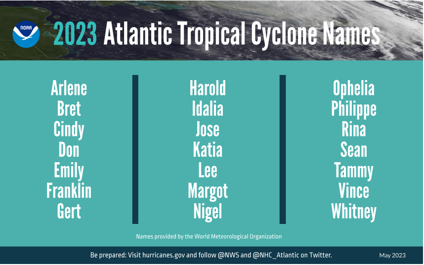
With the start of hurricane season, one of the most common questions often revolves around the name list. Well, here you go, courtesy of NOAA:

The other common question is “what’s the forecast?” While it’s important to remember that only one bad storm can make it a bad season for you, we recognize the interest in these forecasts. NOAA released their outlook last week, calling for a “near average” season. Colorado State is expected to update their outlook shortly after this post is published, but it should not deviate a ton from their April view of (also) a near average season. Much of this somewhat reined in expectation is due to El Niño, which is emerging quickly in the Pacific. You can read more about that in those agency’s outlooks, and we’ll certainly get into more on the Niño as the season progresses.

Today marks the beginning of a lengthy marathon through October and into November, and we’re not starting off the year quietly. Just last weekend, we saw a storm system move into the Carolinas with some strong wind gusts and almost 6 inches of rain in the mountains of North Carolina. There was also a cruise ship incident. Today? We’re watching a disturbance in the Gulf of Mexico that has been tagged as Invest 91L. (A reminder: In the Atlantic basin, “invests” are basically defined as “areas of investigation.” In other words, they’re areas of interest that are “tagged” by the National Hurricane Center that allows for a bunch of additional weather model data to populate as a result. There’s no strict definition, and many invests go on to dissipate in time. “L” indicates it’s in the Atlantic, and the number preceding the letter rotates between 90 and 99 and recycles throughout the season)

One-sentence summary

Invest 91L in the Gulf of Mexico has about a 50/50 chance of developing into a depression or low-end tropical storm over the next couple days as it tracks generally south and east, across Florida and into the Atlantic, dumping locally heavy rain in parts of Florida.

Happening now: A difficult road ahead for 91L

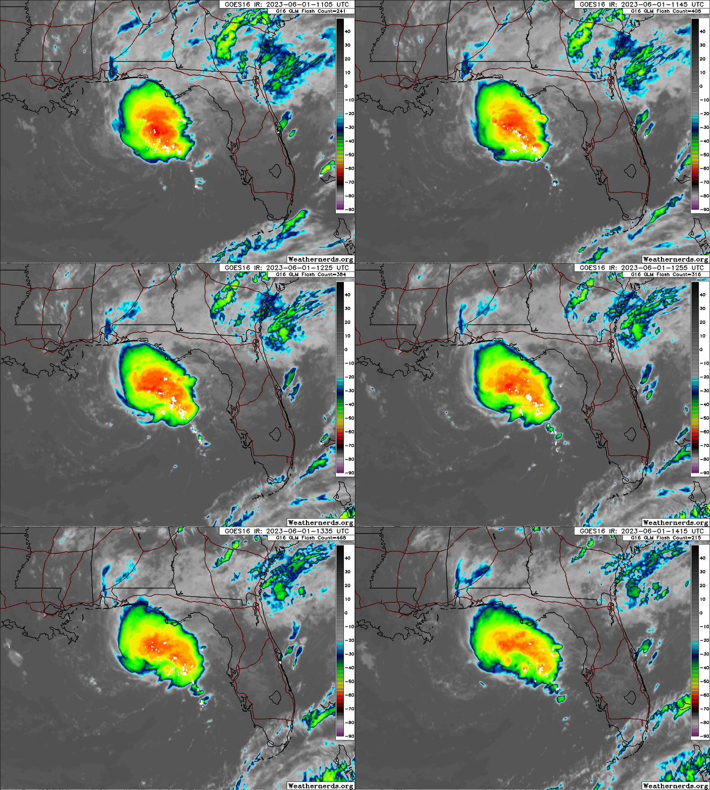
This morning, Invest 91L looks a bit “blobby” in the northeastern Gulf. There’s basically an area of storms south of Panama City that is sort of stationary or drifting southeast — thankfully offshore.

Invest 91L isn’t the best looking or worst looking invest we’ve seen in the Gulf, but it’s got enough to it to possibly become a depression or weak tropical storm over the next couple days. (Weathernerds.org)

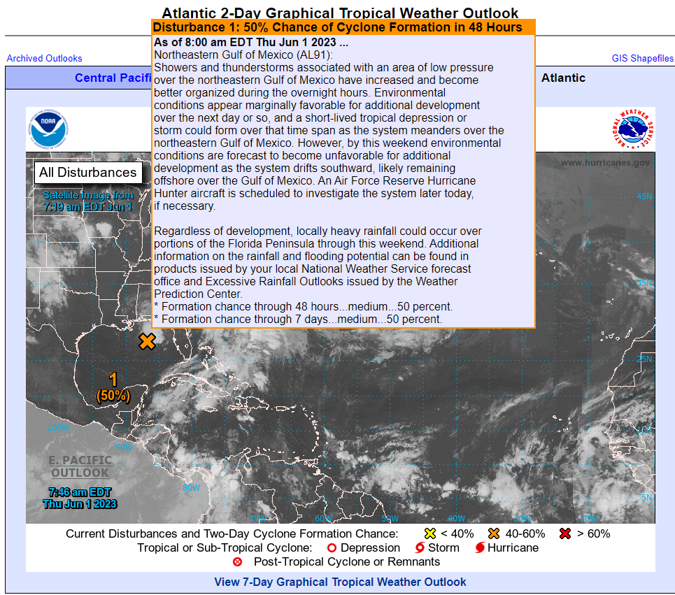
Radar estimates that 8 to 10 inches of rain has fallen over the open water of the Gulf. If you look close enough, you can definitely see a little “spin” to the cluster of storms as well. There is not a super well-defined low pressure system in the Gulf, but there’s something defined there. Thus, the National Hurricane Center bolstered odds of development to 50 percent over the next 48 hours this morning.

The National Hurricane Center says 91L has about a 50 percent chance of developing into a depression or storm — briefly — over the next couple days. (NOAA)

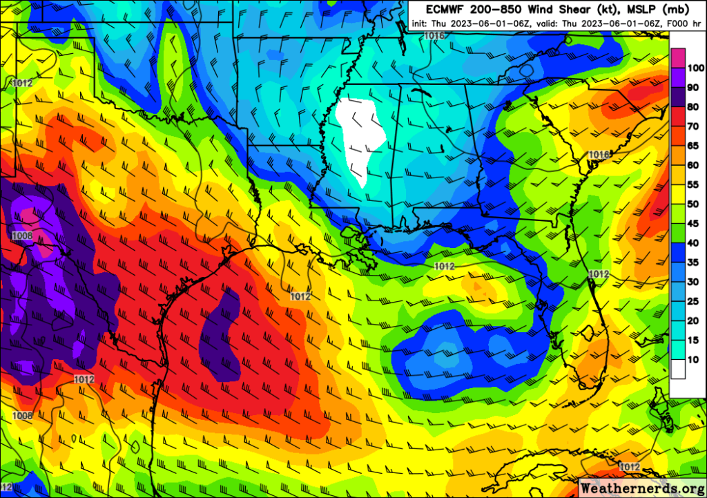
Wind shear is going to be a significant inhibiting factor for development of 91L. I would not say it’s in a low shear environment by any means right now, but in about 48 to 72 hours, it’s going to be in a very rough one.

This image shows a good proxy for the kind of shear environment 91L is experiencing at the moment, with darker colors indicating higher shear. 91L is currently in a relative “lull” in this high shear environment, which is not hindering its development today. This will change by the weekend and shear will act against 91L’s future development. (Weathernerds.org)

When tropical systems develop, they like a generally calm atmosphere around them. Wind shear indicates a lot of turbulence and usually acts to slow or even prevent storm development. It’s important to note that with systems this close to shore, wind shear does not prevent impacts; it can still rain a lot or be breezy or even flood some at the coast. But it does usually put a cap on how strong or well-organized a storm can become.

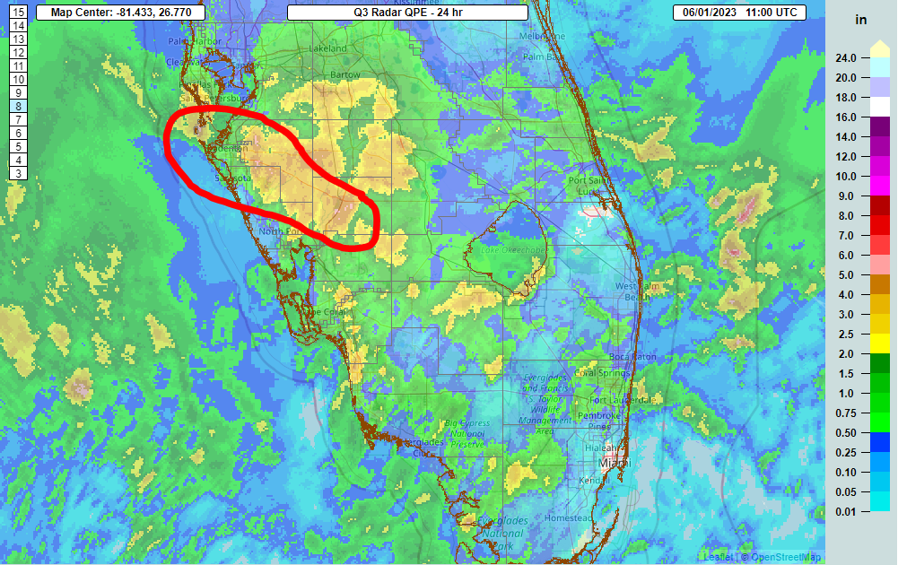
For Florida, the main impact from 91L should be a bolstered chance of showers and storms with locally heavy rainfall. We saw this yesterday with portions of DeSoto and Manatee Counties in southwest Florida seeing over 4 or 5″ of rain.

Yesterday, portions of Florida’s west coast saw upwards of 5 inches of rain, primarily in DeSoto and Manatee Counties, east of Sarasota and Bradenton (NSSL MRMS)

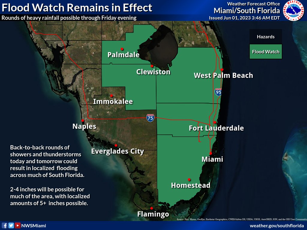
Additional rains are expected in Florida over the next few days, with amounts generally 1 to 2 inches with isolated higher amounts possible. Because of that, there is a flood watch in effect for coastal southeast Florida, including Miami-Dade, Broward, and Palm Beach Counties, as well as around Lake Okeechobee.

Miami’s National Weather Service office has a flood watch hoisted through tomorrow for Miami-Dade, Broward, Palm Beach, Hendry, and Glades Counties. (NWS Miami)

Bottom line: Invest 91L has about a 50/50 shot of becoming a depression or weak tropical storm before Saturday, but it would likely remain on the weak side. That said, there is a legitimate risk of flash flooding due to heavy rain, particularly in southeast Florida but also potentially in a few other Peninsula locations as well. 91L will race off to the east next week into the open Atlantic.

This is a good reminder to get your hurricane kits stocked and review your evacuation plans for later in the season.

Medium term (Days 6-10): Minimal action

There is not a lot showing up in the medium range horizon right now that supports tropical development. There will be a non-tropical system in the Northeast next week, leading to rain and ugly June weather for New England, with Boston not escaping the 50s for a couple days. But nothing is out there in the tropics.

Fantasyland (beyond day 10): Quiet

We will cover the “fantasyland” section each day. We often see models place rogue storms late in their runs (day 10+), and often that is what drives social media fear and hype over storms. We’ll let you know a little about the extended range period here, and if there’s reason to take those periodic scares seriously. Today, there’s little to nothing to speak of in fantasyland. The models have been fairly well-behaved of late in terms of showing any rogue systems. So, we expect mostly quiet conditions overall through mid-June.

Our next update will come tomorrow morning, or this evening if 91L happens to get an upgrade, as hurricane hunters are scheduled to investigate this later today.

03 Jun 13:42

Tropical Depression 2 forms in the eastern Gulf of Mexico; no change to expected impacts

by Matt Lanza

Good evening! Welcome again to The Eyewall. We did not expect to be actually covering a storm on day one, but here we are. This is the type of coverage you’ll get with every Atlantic system on this site.

Based on data collected from Air Force Reserve Hurricane Hunter aircraft this afternoon, Invest 91L was classified as Tropical Depression 2 in the eastern Gulf of Mexico.

Wait– Why TD 2? What happened to TD 1?

Back in mid-May, the National Hurricane Center (NHC) determined that a subtropical storm formed off New England back <checks notes> January. Thus, when the 2023 season is in the books, that storm will have the honor of being Storm 1. However, it did not take on the name Arlene since it was classified after the fact. Thus, since this is the second cyclone of the season, it is classified as TD 2. If it becomes a tropical storm, it will be named Arlene. Got it? Good.

Where will TD 2 go?

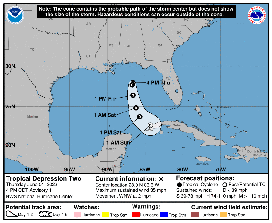
The official forecast from the NHC looks good. It’s headed south.

TD 2 will track due south over the next couple days, possibly strengthening to a tropical storm before dissipating near Cuba this weekend. (NOAA)

This system is unlikely to maintain status long enough to make landfall anywhere, so there are no watches or warnings posted for any coastlines. TD 2 will drift southward through Saturday before likely dissipating on Sunday (if not sooner) near Cuba.

What impacts should we expect? Florida rain!

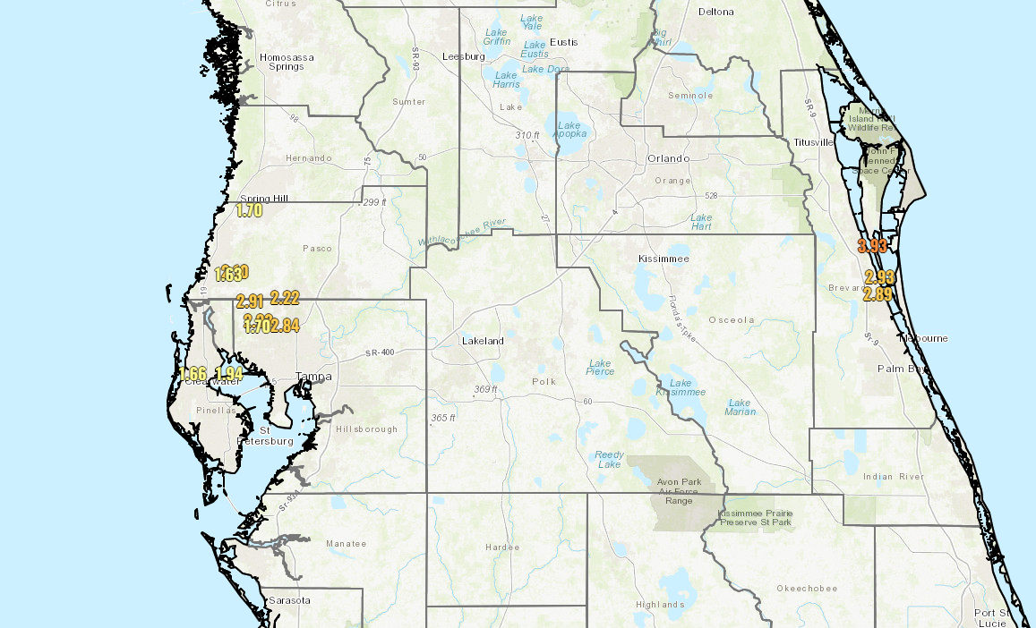
As we noted earlier today, the primary thing to watch will be rainfall in the Florida Peninsula. Hardest hit so far today has been central Brevard County in Florida, where radar estimates 3-5″ of rain has fallen. Also, the north side of the Tampa Bay area has seen some heavy rain as well. The map below shows rain totals since about 5 AM today for places that have received over 1.5″ of rainfall.

Click to enlarge rainfall totals exceeding 1.5″ so far today across central Florida. (NOAA)

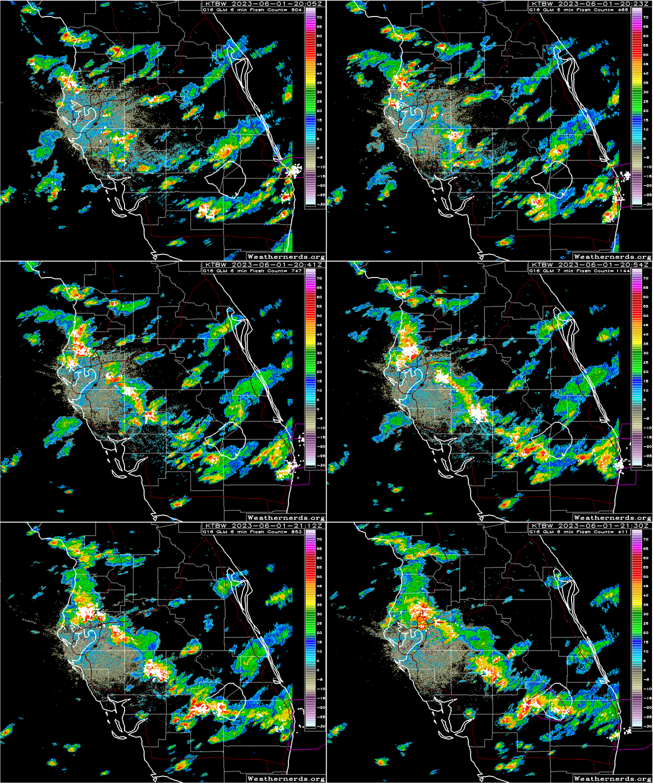
Radar shows pockets of heavy rain extending from the Tampa area south and east across the Peninsula to near Lake Okeechobee before things tail off some. There are also very heavy storms over Delray Beach on the east coast, up through Boynton Beach as well.

Radar through 5:40 PM ET shows areas of heavy rain and lightning from near Tampa south and east to Lake Okeechobee. (Weathernerds.org)

The bottom line in all this? Localized flash flooding is possible. You can see from the rain totals that some areas have seen manageable rain so far. Others have seen up near 5″ the last couple days. Those areas will be most sensitive to flooding, and that’s why there’s a flood watch for South Florida. More showers and storms will be likely tomorrow before things settle down a bit.

The final word?

TD 2 may briefly become a tropical storm tonight or tomorrow before it drifts south toward Cuba and dissipates this weekend. The main issue will be heavy rain and localized flash flooding across the Florida Peninsula, as well as perhaps in portions of Cuba (Havana has seen some very heavy rain today). But it’s likely that there will be little trace of TD 2 left by Sunday.

More in the morning!

03 Jun 13:40

Tropical Depression 2 struggling over the open Gulf; isolated heavy rains for Florida

by Matt Lanza

Good morning, and welcome again to The Eyewall, where we provide hype-free, measured coverage of the Atlantic tropics all season long.

Today, we wake up to Tropical Depression 2 in the Gulf no better organized than it was yesterday evening, and struggling somewhat. TD 2 itself is more of a meteorological curiosity than anything else, although heavy rain continues to be possible in portions of the Florida Peninsula.

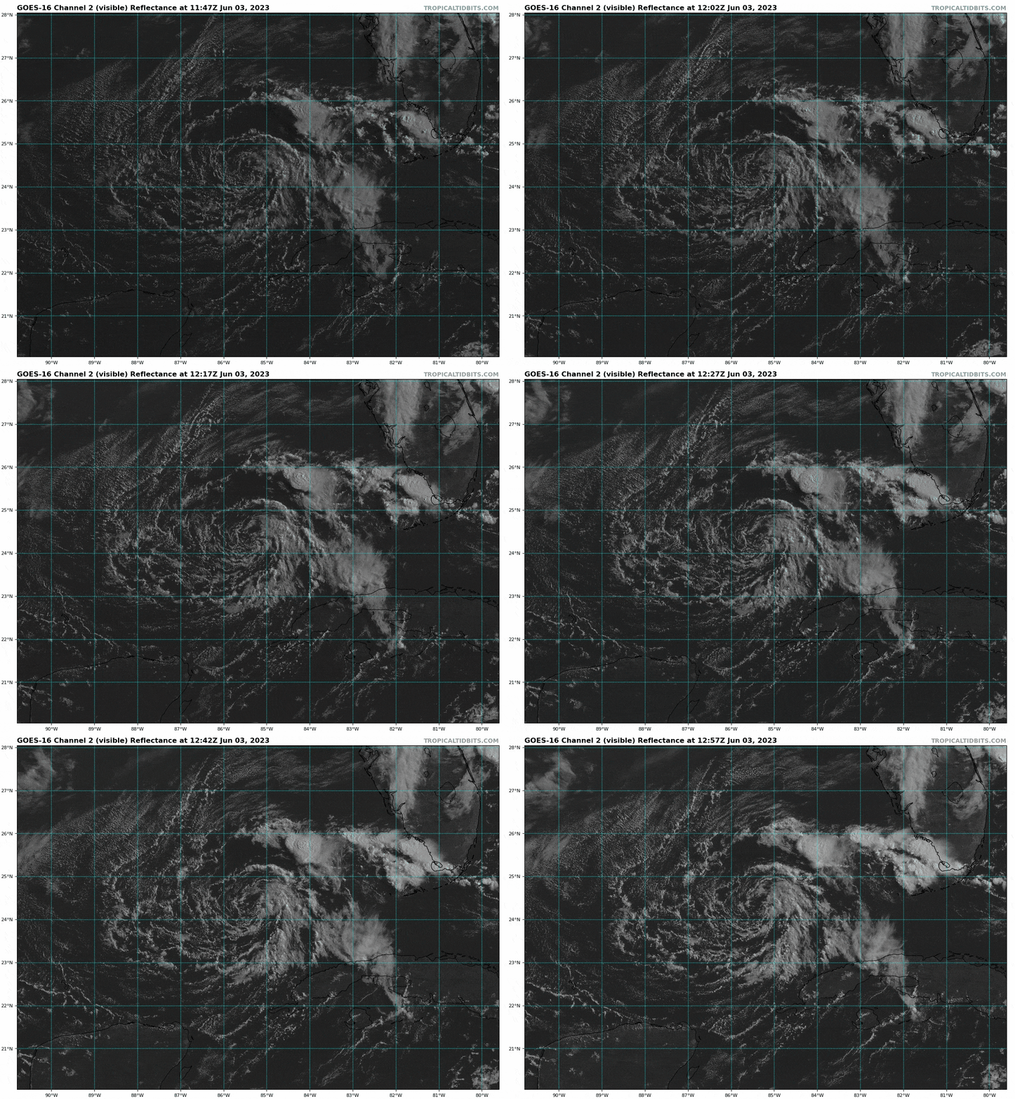
Tropical Depression 2’s center is displaced south and west of the main cluster of storms, indicating a poorly organized, heavily sheared system. (Tropical Tidbits)

One-sentence summary

Tropical Depression 2 is expected to drift south toward Cuba and dissipate this weekend, and although it may still technically attain tropical storm status and will aid in Florida storms, it is not a direct threat to anyone.

All things Tropical Depression 2: Meteorological curiosities and rain in Florida

Again, the system itself is not really an issue for anyone. It’s fairly weak and over open water. From the satellite loop above, you can actually sort of see the center of TD 2, exposed to the south and west of the green-yellow-orange colors, which are thunderstorms south of the Panhandle. That’s an indication of an unhealthy, sheared system. As visible satellite imagery becomes available today, we may see this enter “naked swirl” territory (where the center is completely displaced from any storms). Still, per the National Hurricane Center 4 AM CT discussion, TD 2 may technically be close to being a tropical storm. All you need is an area of 34 knot (39 mph) sustained wind to technically classify it, hence this is mostly a meteorological curiosity at this point.

At a high level, the forecast track for TD2 is mostly unchanged versus yesterday. It drifts south in the Gulf before dissipating near Cuba on Sunday.

The curious track of TD dissipates it near Cuba this weekend. (NHC)

Several of you have mentioned, “You know, that’s a bizarre track. Is that normal?” The answer is “No, it’s not technically normal.” It is certainly funky, but often (especially in early season), storms can take these weird tracks. All tropical storm tracks are generally a function of the environment around them. And if we look about 20,000 feet (at what meteorologists call the 500 mb level) over our heads at what’s happening, it becomes fairly clear to see why TD 2 takes this type of track.

The 500 mb (~20,000 feet up) map shows that TD 2 is being steered by a strong north or northwesterly push aloft, which helps to drive it southward. (Tropical Tidbits)

The red “L” in the middle of the map, which is a forecast of 500 mb vorticity this afternoon is the approximate location of TD 2. The pattern features strong northerly or northwesterly winds which help to direct the western portion of TD 2’s broader circulation south. Steering currents over Florida and Georgia are fairly weak, so there’s little influence from there, hence all this northerly push pretty much forces TD 2 southward. Winds out of the southwest across Cuba and into the Bahamas help to give it that little eastern turn late, but of course by then, it will have pretty much dissipated.

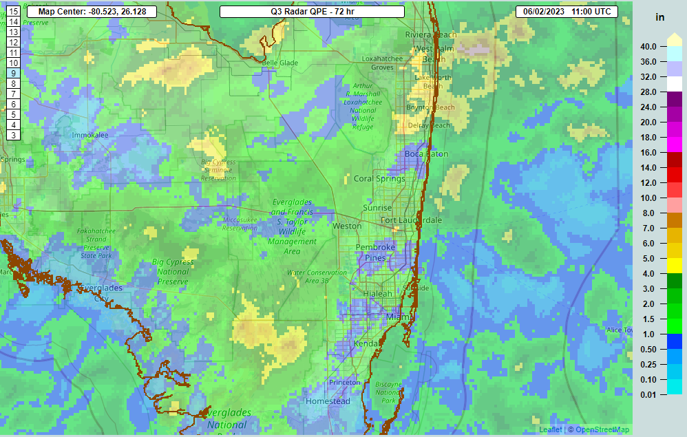
So, TD 2 is not a direct threat to any land, but the convoluted pattern around the system will help to continue aiding rainfall in parts of Florida today. Flood watches continue for the southeast coast, from Miami-Dade through Palm Beach Counties and around Lake Okeechobee. Over the last three days there have been isolated spots seeing in excess of 3 to 5 inches of rain.

Rainfall over the last three days has led to a couple “bullseyes” (yellow & orange) around South Florida. (NSSL MRMS)

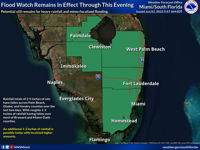
Because of this, and because of the potential that some showers and storms could produce a few more inches of rain and lead to flash flooding, the flood watch continues.

A flood watch continues for much of South Florida, with another 1 to 2 inches of rain (or a bit more) possible in isolated spots today. (NWS Miami)

Not all of South Florida will see heavy rain, but some will today and perhaps even Saturday too before things start to return to normal next week and TD 2 experiences its demise.

Medium range (days 6 through 10): Nothing doing

The day 6 through 10 period looks pretty quiet. I would expect the majority of the basin will be covered by decent wind shear, which acts to limit storm development. In addition, it looks like we’re in an unfavorable upper level pattern overall, with more sinking air across the basin as well. It is June, after all, so that shouldn’t come as a surprise.

Fantasyland (beyond day 10): Also quiet

This quiet will probably extend firmly through mid-June and possibly (hopefully?) into late June. Nothing is showing up in the long range that should ruffle any feathers right now.

We’ll be back tomorrow with a quick update on TD 2. Look for our normal daily update on Monday morning, where we’ll tackle what is normal for June as the season begins.

03 Jun 13:37

Arlene comes and Arlene goes

by Matt Lanza

Tropical Depression 2 was upgraded to Tropical Storm Arlene yesterday afternoon, and as I am writing this, Arlene is on its way out. Here now, a quick recap of 2023’s first named storm.

No, but seriously, Arlene is on the way to dissipation later today or tomorrow. Looking at a satellite image today, Arlene is more curious looking than menacing.

Tropical Storm Arlene is a swirling area of clouds and isolated thunderstorms at this point, and should be downgraded to a depression or remnant low later today. (Tropical Tidbits)

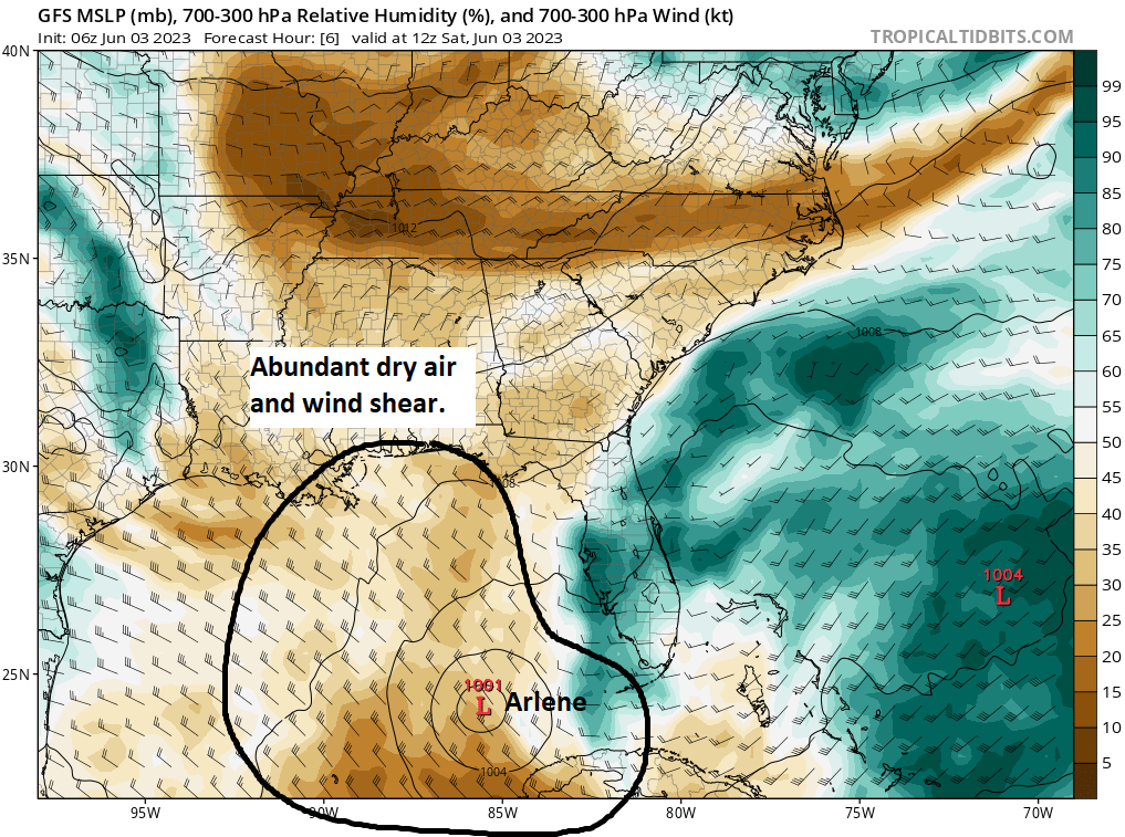
There are some thunderstorms still on the far northeast side of Arlene, but that’s about all right now. The center is clearly visible, but without thunderstorms around that center, it’s clearly evident that shear and dry air are doing work. A forecast map from the GFS model that shows wind speed and direction (indicated by the little barbs on the map) and relative humidity in the upper atmosphere (brown = drier air and green = more moisture) shows that Arlene is in a very dry, very hostile (windy) environment aloft. This is a good recipe for disorganization, and as such, Arlene’s end game is clear.

Arlene is surrounded by dry air and under a high wind shear environment, which means it’s inevitably about to fall apart. (Tropical Tidbits)

So we’ll call that a wrap on Arlene for all intents and purposes.

Florida rainfall chances

For Florida, which on the map above is covered in higher moisture, there will continue to be rounds of thunderstorms today, and the National Weather Service in Miami continues the flood watch from Miami-Dade through Palm Beach Counties and around Lake Okeechobee. The heaviest rains on Friday fell north and west of the lake and between Tampa and Orlando.

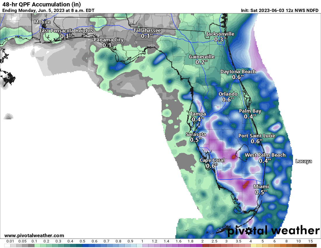
Forecast rainfall through Monday morning in Florida, with isolated heavy rain likely between the Keys, Miami, and Tampa.

Rain totals as forecast above will be quite variable (and may be placed a bit differently than shown in the forecast). Some areas may see a quarter to half-inch or less, while others could easily see 2-4 inches of rain between now and Monday, so watch for ponding and areas of localized flash flooding, especially in spots that have seen a good bit of rainfall this week. Also, as is occasionally the case with tropical thunderstorms, we could see reports of waterspouts or even some isolated strong to severe storms today or tomorrow in South Florida.

Otherwise, that’s all to discuss. We’ll be back on Monday with our daily tropical update and a look at some seasonal forecasts for this year. Enjoy the weekend!

03 Jun 13:30

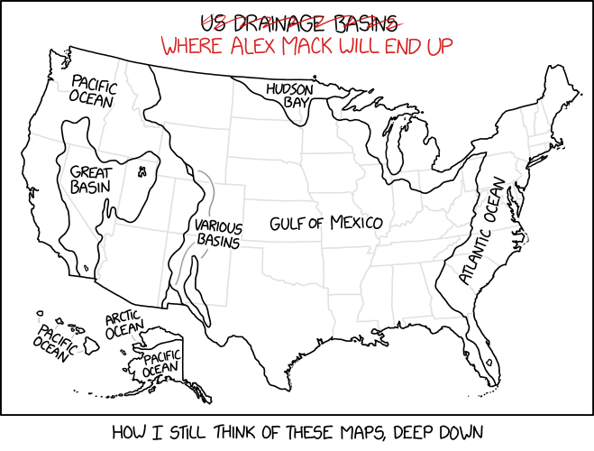
Drainage Basins

After a pail of water was thrown on the Wicked Witch of the West outside Salt Lake City, Utah's Great Salt Lake was measured to be 7 parts per trillion witch by volume.
03 Jun 13:28

How to Find Your Size in Blue Jeans

by Tori Multon

For the Gentlemen

1. Get out your measuring tape. Measure your waist.

2. Measure from your crotch to your foot.

3. Take those two numbers in the order you measured yourself. You are ready to buy pants.

For the Ladies

1. At what age did you first learn about death?

2. Add one for each member of NSYNC you can name—be honest.

3. Did you think about carbs today? How many times? (Add one per instance.)

4. What is your star sign? We figured we’d ask in case no one has asked you today, even though it doesn’t change your pants size.

5. Have you dressed in athleisure most weeks since 2020? (Add four.)

6. Subtract two if donning denim pants doesn’t involve grunting and flopping on the floor like a spawning, half-dead, and rotted-out salmon.

7. Do you know how to reset your router or attach a photograph to an email? Take away a third of your size.

8. If your butt were food, what food would it be?

  • A sack of raw flour (subtract one)
  • Personal watermelons (add five)
  • Gluten-free ciabatta sprinkled with artisanal Parisian herbs (leave the number as is)
  • Two jiggly mounds of flan (add three)

9. Can you describe what dial-up sounds like? (If yes, add five.)

10. Get out your measuring tape. Measure the smallest part of your waist if you like high-waisted pants. If you prefer pants down at your navel, measure there. Subtract this number from your running total. (It doesn’t matter. Nothing really matters.)

11. How many one-size-fits-all items do you own that fit you? (Add this number to your running total.)

Now you might be ready to buy pants. This method is about as accurate as measuring your body. Size up if you are buying clothes in the United States. Don’t forget that odd-numbered pants are smaller than the others. Size down to an even number if you prefer nice, even numbers and denim without holes or “distressing.”

03 Jun 13:25

Abbott appointee resigns as chair of power grid regulator

by Erin Douglas
Public Utility Commission chair Peter Lake had spearheaded a plan to help the state’s power grid withstand weather disasters, but the plan lacked support in the Texas Legislature.
03 Jun 13:24

Lo-Fi

by tom cardy
02 Jun 21:57

Here is the first livestream from Mars — a rare, almost real-time look into space

by Juliana Kim
In this handout image supplied by the European Space Agency on July 16, 2008, the Echus Chasma, one of the largest water source regions on Mars, is pictured from ESA

On Friday afternoon, spectators had a chance to see the most current images of Mars possible — which take 3 to 22 minutes to reach Earth — courtesy of the European Space Agency.

(Image credit: ESA/Getty Images)

02 Jun 21:51

Ken Paxton impeachment moves to Texas Senate, where conflicts of interest, political intrigue await

by Patrick Svitek
Senators have been publicly silent, citing their role as jurors with a weighty decision: whether to remove one of the state’s top Republicans from office.
02 Jun 21:50

Tropical Storm Arlene Graphics

by nhcwebmaster@noaa.gov (NHC Webmaster)
Tropical Storm Arlene 5-Day Uncertainty Track Image
5-Day Uncertainty Track last updated Fri, 02 Jun 2023 17:25:56 GMT

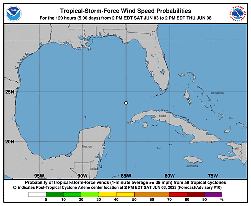
Tropical Storm Arlene 34-Knot Wind Speed Probabilities
Wind Speed Probabilities last updated Fri, 02 Jun 2023 17:25:57 GMT
02 Jun 21:49

Summary for Tropical Storm Arlene (AT2/AL022023)

by nhcwebmaster@noaa.gov (NHC Webmaster)
...AIR FORCE HURRICANE HUNTERS INDICATE DEPRESSION HAS STRENGTHENED INTO TROPICAL STORM ARLENE... As of 1:00 PM CDT Fri Jun 2 the center of Arlene was located near 26.7, -86.2 with movement S at 5 mph. The minimum central pressure was 1002 mb with maximum sustained winds of about 40 mph.
02 Jun 21:48

European satellite beams back its 1st livestream from Mars

by The Associated Press
Mars-Ancient Microbes

A European spacecraft around Mars sent its first livestream from the red planet to Earth on Friday to mark the 20th anniversary of its launch, but rain in Spain interfered at times.

02 Jun 21:24

Ken Paxton impeachment moves to Texas Senate, where conflicts of interest, political intrigue await

by Patrick Svitek, Texas Tribune
Senators have been publicly silent, citing their role as jurors with a weighty decision: Whether to remove one of the state’s top Republicans from office.
02 Jun 21:23

Rain chances ease back into Houston’s forecast this weekend

by Matt Lanza

Happy Friday! We continue to see humidity running a little below average for this time of year in Houston, which may be <laughs mockingly> hard to believe, but it’s true! This weekend, we’ll see shower chances slowly re-enter the forecast, especially Sunday, as we heat up temps to 90 or a bit hotter.

In the tropics, yesterday started hurricane season and right on cue Tropical Depression 2 formed. It is not a concern for Texas and will just help to offer enhanced rainfall in Florida and Cuba. Read all about it on our new companion site, The Eyewall. Thanks to all who commented, liked, shared, and subscribed to our posts there. Keep spreading the word. We’ll be using The Eyewall to cover the entirety of the Atlantic basin just like we cover Houston here, a duty to which we remain fully committed!

Today

Look for sun, minimal rain chances, and temperatures around 90 degrees, give or take. We continue to battle air quality issues, and today is (again) an ozone action day, so please use caution if you’re in a sensitive group. We may see some improvement over the weekend. I don’t know that this is abnormal, but it sure has felt excessive since early May, something we know you’ve noticed.

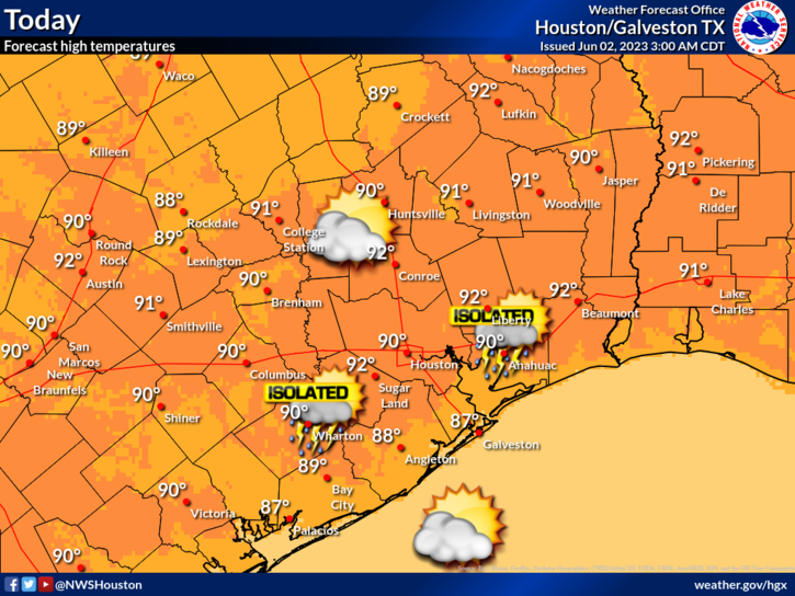
A fairly typical early summer day awaits the Houston area, with very low-end rain chances Friday. (NWS Houston)

Rain chances are not zero, but they are rather low today. Still, you can never entirely rule out an isolated downpour in June.

Saturday

For the most part, Saturday should be a repeat of today. However, rain chances may be more like 10 to 15 percent versus the 10 percent or less that they are today. This may be especially true north of Houston. Expect morning lows in the upper-60s to low-70s, with a daytime high of 90 or better in most spots.

Sunday

Rain chances bump up for Sunday late morning or afternoon. Look for sun, some clouds, and temperatures near 90, after a morning low near 70 degrees or a touch warmer. Isolated to scattered showers and storms are likely to fire through the day, with some areas seeing an inch or two of rain and others seeing nothing. Coverage should be somewhere at least in the 30 to 40 percent range.

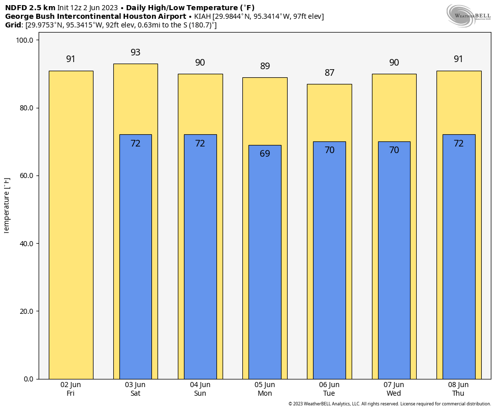
Temperatures over the next week or so will reach their bottom with higher rain chances Monday and Tuesday before slowly creeping back up toward next weekend. (Weather Bell)

Next week

Look for additional isolated to scattered showers and storms on Monday and Tuesday. Things should gradually ease back to slight, hit or miss rain chances by later in the week. So your best odds of rain right now are Sunday through Tuesday. But even then, some of us may not see much, while others may get a few rounds of showers or storms. It will be an irregular pattern of rain. Look for temps to lull a bit early in the week due to clouds and showers, before warming back up later in the week. Rain chances should back off some after Tuesday or Wednesday, but we’ll see if that trend holds.

02 Jun 21:21

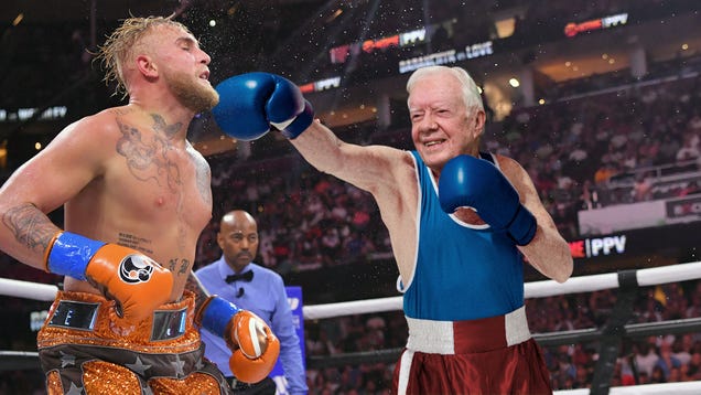
Jimmy Carter Wins Boxing Match Against Jake Paul

ATLANTA—The heavily anticipated fight between the former U.S. president and the YouTube personality ended in a TKO Thursday night as Jimmy Carter won his debut boxing match against Jake Paul. The cruiserweight match, first announced in early April, pitted the 6-foot-1, 191-pound Paul against the 5-foot-10, 190-pound…

Read more...

02 Jun 21:20

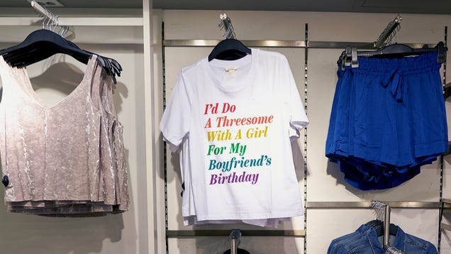
Target Scales Back Pride Section To Single T-Shirt Saying They’d Do A Threesome With A Girl For Their Boyfriend’s Birthday

MINNEAPOLIS—Responding to conservative backlash over a large selection of offerings for the month of June, Target announced Friday that they would scale back their gay pride section to a single t-shirt, saying they’d do a threesome with a girl for their boyfriend’s birthday. “It’s a one-night-only thing, and we’ll…

Read more...

02 Jun 21:20

Denver Nuggets’ Rocky Revealed As NBA’s Highest-Paid Mascot With $625,000 Salary

A new report revealed that the Denver Nuggets mascot, Rocky the Mountain Lion, is the NBA’s highest-paid mascot, taking home $625,000 a year, almost 10 times that of the average $60,000 salary for a league mascot. What do you think?

Read more...

02 Jun 14:09

Our Seventh-Grade Band Concert Tickets Are Now for Sale on Live Nation

by Jonathan Weisberg

Dear Parents,

We are pleased to announce that Adams Middle School has partnered with Live Nation to make it easier for you to purchase tickets to the upcoming Seventh-Grade Band Concert and all future performances, including the much anticipated Waiting for Godot: The Musical, written by our own Ms. Kelley. The cost of all tickets will still be just $5, plus a convenience fee of $20.95, a processing fee of $1.17, an equity tax of 0.2% of your gross annual income, a translation fee of $4.22, a hazard abatement surcharge of $0.22, a mandatory concession purchase of at least two burned brownies and one cookie with giant generic-brand M&Ms that taste like peas for $12, an optional upgrade of $42 for seats where you can actually see your child, and local sales tax of $0.42 (which I should note is not the company’s fault).

We anticipate huge time savings at the performance, as you will no longer have to stand in line at the card table while Mrs. Ramone looks for your name on the list of “good parents” who remembered to purchase advance tickets. Just download the Live Nation app, and give it permission to access your photos, contacts, social media activity, location, and at least one bank account, and you’ll be just one search and seventeen taps away from scoring those prized front-row seats that are set so close to the tuba player that he might drop his instrument on you!

Another advantage to this platform is that you’ll be able to resell your tickets safely and legally if you cannot make it to the concert. Say your kid gets a stomach bug just before the big show, and you’re mopping up the spattered half-digested remains of that day’s chicken finger and macaroni lunch special, and you’re thinking, This is actually better than listening to twelve-year-olds play “Carnival of the Animals.” But you’re bummed to be out five bucks. Well, now you can use the app to put your tickets on the block and maybe help out another Adams family that has found itself with a last-minute need for additional seats. Resale fees may apply.

Live Nation’s concessions team will run the bake sale table this year. We expect significant improvements from private enterprise here. They’ll take the coffee cakes, cupcakes, and unidentifiable treats you donate, put them on new, color-coordinated paper plates and sell them back to you at a 400 percent markup. We get a 2 percent royalty on all sales. So dig deep to support our band.

Live Nation affiliate PerfectImage will also record the performance and use exciting new AI technology to capture your child’s likeness. You’ll be able to order the full concert video, a version that shows your child sitting center stage in front of everyone and playing as if they’d actually practiced, or deep fake versions with your child starring in Mama Mia!, West Side Story, Apocalypse Now, or any of hundreds of other major motion pictures. By participating in the concert, you agree to give PerfectImage the rights to use your child’s likeness and any image derived from it in any media now existing or yet to be invented in perpetuity and indemnify the company against any possible future claims that your child is in any way a derivative work of other copyrighted work. Please note that our contract with Live Nation forbids photography or video during the performance.

Remember to use the hashtag #AdamsBandbyLiveNation on all your social posts (but again, no photos). I signed a contract that committed to at least five hundred posts generating 25,000 impressions, and if we don’t meet that goal they will repossess our school’s mascot box turtle, Fred. So let’s all show some Adams Spirit (sponsored by Live Nation)!

You may notice company representatives in the gym to monitor our compliance with the licensing and exclusivity terms of our agreements. They will be armed and empowered by our contract to protect the interests of Live Nation during the performance. For your own good, do not even think of taking any photos or videos.

We’re looking forward to a busy end of the year with our annual student-staff softball tournament, sponsored by Lockheed Martin, featuring surface-to-air flyball interdiction. And don’t forget our Eighth-Grade Stepping Up Ceremony, which will conveniently be held in the parking lot of the Johnsonville Meat Packing Plant so that all the new graduates can immediately start their first shift now that it’s legal for thirteen-year-olds to work the overnight.

Sincerely,
Principal Mike

02 Jun 13:12

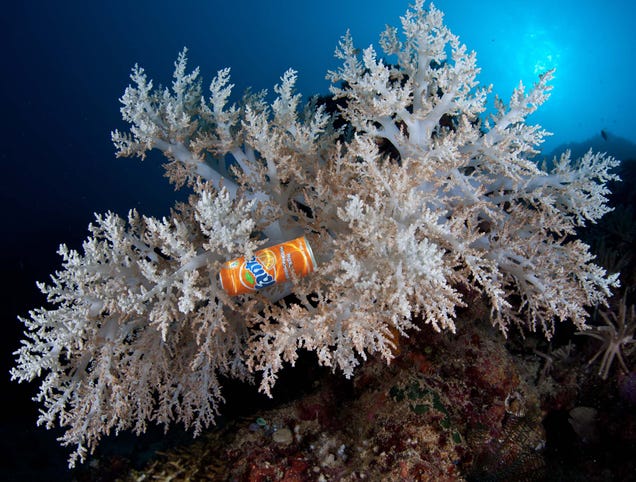
Submerged Trash Adds Welcome Pop Of Color To Bleached Coral Reef

02 Jun 12:55

Comic for 2023.06.02 - 5 Years

New Cyanide and Happiness Comic
02 Jun 07:34

my employee keeps venting to me about his divorce, trust-building activities that actually work, and more

by Ask a Manager

This post was written by Alison Green and published on Ask a Manager.

It’s four answers to four questions. Well, three questions and one story. Here we go…

1. My employee keeps venting to me about his divorce

I manage a team of 20. I have two supervisors on my team and one is going through a divorce. He (male, 55) calls me (female, 33) constantly wanting to vent, and he sends me long-winded emails telling me how great a manager I am and how much he feels valued and appreciated. It’s gotten uncomfortable. I try to redirect conversations and only keep them about work because he will consume my time and end up telling me all about his wife and their troubles. I don’t want to hear about it, it’s a waste of my work day, and I’m not his therapist. He often asks for advice and what I would do in a relationship, which I try to deflect.

I don’t want to be mean and I try to support everyone on my team, often letting staff cry in my office when they are going through a tough time (death in the family, difficult customer, project failures, etc.) but he is draining, I feel like he’s crossing boundaries, and honestly the guy has an unhealthy crush. He’ll call multiple times a day asking if he can vent about his wife! He even started texting me after hours! I never respond to the texts and only halfheartedly say things like “that sounds tough, I’m sorry you’re going through this.” How do I professionally let him know that I’m not his sounding board without damaging the professional relationship I need to maintain?

“I know you’re going through a tough time, but since I need to be your manager I’ve realized I can’t be your sounding board about this. I need to keep our conversations focused on our work.”

And then if he keeps bringing it up after that: “I’m sorry to interject, but I’ve got to keep my manager hat on here so we can’t delve into this. But I did want to ask you about (work topic).”

You might feel awkward saying this — it’s inherently a bit of an awkward message to deliver! But the only way to address it is by saying it and getting it out there … and it’s in his best interests to have you clearly set that boundary before he goes even further with it.

Also — keep in mind he might be waylaying other colleagues with this as well (especially female ones, if he’s the type of guy who sees every woman as a potential therapist) and keep an eye out for that too.

2. Trust-building activities that actually work?

My fully remote department is about to have its first-ever in-person retreat. The pandemic has been a roller coaster for my team in many ways (high burnout and turnover, abrupt changes in leadership, crises of values/mission, etc.), and our department lead has asked us for suggestions for activities. I am hopeful that this might be an opportunity to restore trust, build comraderie, and create a more sustainable foundation moving forward. However, I am well aware that many team-building or trust-building exercises are ineffective, invasive, or inappropriate (having read as much from others who have written in over the years), and would like to avoid that. Do you or other readers have any suggestions for trust-building activities (or other types of team-focused exercises) that actually work?

I honestly don’t think they do. Trust-building exercises won’t fix the damage from the sorts of things you describe; your organization needs to address the core issues themselves. Even in companies without those kinds of deep-rooted problems, the only real way to build cohesion and morale is by creating a positive, cooperative culture year-round, not just for the duration of a team-building event. In fact, when companies try to use these events as a substitute for more meaningful work, they can end up lowering morale instead.

One thing you might try instead is using some of the retreat time to listen to what people think is needed to move forward in a more sustainable way, and coming up with actionable steps from that. (But if realistically nothing will change as a result of that, doing it is likely to add to the existing problems by just increasing people’s cynicism.)

3. Should I ask interviewers if they have internal candidates?

I’ve seen some viral posts on social media advising job candidates to ask interviewers whether they’re considering any internal candidates. The idea is to have a more realistic idea of your chances, or possibly to know whether you should emphasize traits an internal candidate might not have. Do you think this question is a good idea? It’s definitely tempting, but I don’t know if hiring managers would appreciate it.

Most of the time it won’t tell you much. Sometimes there are internal candidates who have no chance of being hired (see yesterday’s letter about that). Sometimes there are solid internal candidates but the company wants to hire someone external with a fresh perspective, or they’re committed to hiring the best person regardless of whether they’re internal or external. So the answer won’t really tell you much about your chances, even though a lot of candidates are convinced it will.

4. A cautionary tale about using your internet username on a resume

A humorous horror story and healthy reminder to never use your personal username/email on anything related to your professional persona:

A few years back, I had a friend who made an impressive amount of money through her side hustle of making custom Funko Pop toys. She was very good — people got Pops of themselves to use as wedding cake toppers, of their favorite characters from old shows, of people they knew to give as gifts, etc. It took up all her free time, so if I wanted to hang out with her, it made sense for me to learn to make some, too.

To make them, you pick the head and body that most closely resemble the character you’re building (typically two different Pops), boil the dolls to soften the rubber, pull their heads off, swap them, cut off unwanted parts with a heated knife, sculpt new accessories in clay and attach, and then paint the whole thing. Kinda cool. I did three sets before I lost interest, and saved the photos in some Picasa-style online album (not a social media site) so I could show other people.

Fast forward to this year, and I was making some new business cards for an upcoming conference. I’ve always used the same email address and username for everything and it’s never been a problem. I’ve googled the email address to make sure that nothing bad came up, and it was always fine. But this time, I decided to google just the first part of the address (the part before the @) just to make sure.

There, on the top of page 1: doll parts. Vats of boiling dolls. Dolls with their heads ripped off. Dolls getting body parts chopped off with hot knives. Tubs of dismembered doll parts that had been cut off but saved, just in case they fit the need of a future custom. I looked like a full-blown psychopath.

I wasn’t in the photos, and it was my friend’s home instead of mine, but the username is distinct enough that there could be no mistaking whose account it was. The photos have all long since been deleted and I had thought they were all set to private, but the internet has a long and pervasive memory. I guess they’re going to stay on Google indefinitely, despite the files not actually being hosted on the site anymore. I have to wonder, now, how many hiring managers took one look at that and decided to file my resume directly into the trash.

So let this be a reminder to all: select a unique username for all your weird hobbies, and make sure no part of it (no matter how small) is re-used in your email or on your resume!

Oh noooooo. Consider the reminder issued.