The owners of a California taqueria chain have been ordered to pay $140,000 in back pay and damages to employees who met with a “person identified as a priest” to confess workplace sins. What do you think?
The owners of a California taqueria chain have been ordered to pay $140,000 in back pay and damages to employees who met with a “person identified as a priest” to confess workplace sins. What do you think?
Hello on a Sunday, not because the forecast has changed (it’s going to be extremely hot the next 5 to 6 days, with excessive heat warnings in place again), but because I think folks deserve an explanation about this month. Our forecasts have not necessarily been horrible or anything, but we have all been caught by surprise at the ferocity of some of the storms in June. Many of you have lost power at one point or another, some for days, while others have sustained property damage from winds or hail. So, why?
The National Weather Service forecast office in Houston has issued 47 severe thunderstorm warnings this month across the region. There have been a total of 159 wind or hail reports from across the region.
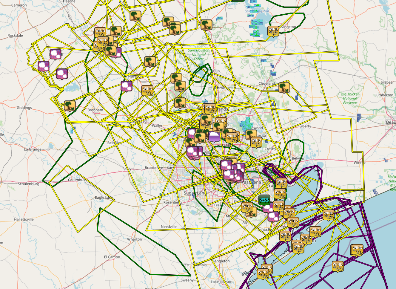
The actual number of damage reports is certainly much higher, as some were surely consolidated or others were not submitted to the NWS office. Whatever the case, it’s been a lot. The only portions of our area mostly spared some element of significant severe weather have been in Fort Bend and Wharton Counties through Lake Jackson and Matagorda Bay.
Let’s quickly recap a few of these events.
June 4th
We were delivered an early wake up call back on June 4th, when storms rolled through the metro area between Midnight and 2 AM or so.
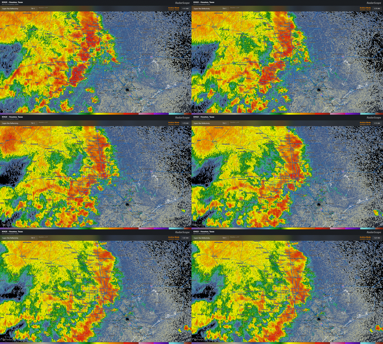
Bush Airport reported a 62 mph wind gusts with these storms, and there were numerous reports of trees and powerlines down. These storms were not expected to hit so hard or quite so soon, so this one caught us a little off-guard. The 3rd was a relatively pleasant day with comfortable dewpoints and highs in the mid-90s (which sounds wonderful given where we are today). But with a weak upper low over Texas, that’s all we really needed to generate storms, and they just managed to survive the trip. Upper lows are notoriously fickle, and as such, we got burned.
June 8th
Wind and hail ripped across the area on the evening of June 8th. This event was better telegraphed than some others this month. We mentioned a good chance for storms and underscored the uncertainty around the storm evolution. So this one didn’t catch us off-guard. But it still ended up pretty vigorous.
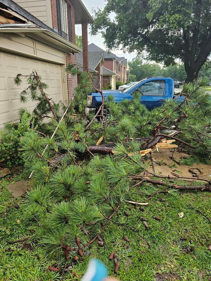
My view from west of I-45 and south of I-610. It’s wild! pic.twitter.com/X1BCmHHnOh
— Dan Mathewson (@dmat909) June 8, 2023
From Houston ship channel pic.twitter.com/V9NWzdkRxm
— Barbi(@Barbi__P) June 8, 2023
Both IAH and Hobby gusted to around 45 mph with these storms, while just off of Texas City recorded a 67 mph gust. Centerpoint had something in the vicinity of 175,000 outages I believe. Hail reports were several, and rain totals of 2 to 3 inches southeast of Downtown Houston produced flash flooding.
June 10th
The storms on Saturday the 10th were also somewhat well telegraphed, as we were outlooked for severe weather and we noted the chance in our posts. The City of Houston was mostly fine in this one, but areas north and east and well northwest of the metro area saw some significant storm reports. Bush officially gusted to 58 mph, while Hobby hit 53 mph. Multiple 60 mph wind gusts occurred in the bays and off Galveston, while hail of golf ball size was reported in Burleson County.
June 21st
This past Wednesday’s storms were utterly ferocious.
Caught a power flicker from the onset of the wind #houwx @mattlanza @JeffLindner1 pic.twitter.com/GmCuXS797t
— loon (@loon) June 22, 2023
Legit storm here at the back of The Woodlands…and power just went out…48kv of Generac just kicked in…@houstonairw @mattlanza @JeffLindner1 pic.twitter.com/tmYDd1rBAc
— Grenade (@Grenade86) June 22, 2023
Bush Airport’s 97 mph gust toppled Hurricane Ike from the top of the leaderboard there, with numerous other locations seeing 50 to 80 mph wind gusts, knocking out power to hundreds of thousands, some of whom remain in the dark as of this morning.
AHHH @mattlanza LOOK HOW COOL I saw it do this once and I waited to see if it would go again and it did! pic.twitter.com/5DmX2elwmx
— 24 Curvies Szn(@lissasauras) June 22, 2023
These storms were poorly forecast. We did talk up rain chances for Thursday, but in reality these came roaring in a good 12 hours faster than anticipated on Wednesday evening, and obviously with more rage than we predicted too. We can look to Friday for further evidence of this as well.
June 23rd
The latest round of violent storms struck on Friday evening with hail and wind. Hail to the size of golf balls and hen eggs fell south and east of downtown Houston and on the west side of the city in two pretty distinct belts.
East end right now. pic.twitter.com/8zyfcQPz9E
— 713cashley (@713cashley) June 24, 2023
Golf ball size hail in the East End. Sustained for several minutes now. @mattlanza @JeffLindner1 pic.twitter.com/FkBpvSwdLp
— Danielle (@wordsfromdani) June 24, 2023
What happened this past week?
So, what exactly was at play this week, and why did we miss the mark on the forecast?
Often times in summer, high pressure tends to “anchor” in one part of the country or another. This month, we’ve seen it anchor mostly over South Texas and Mexico.
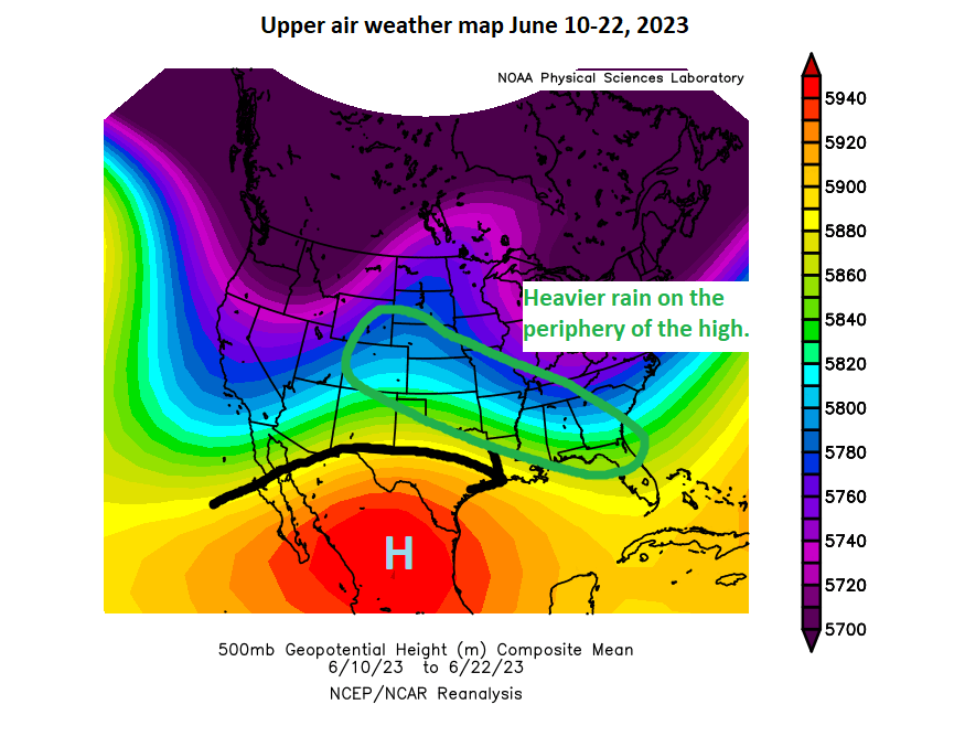
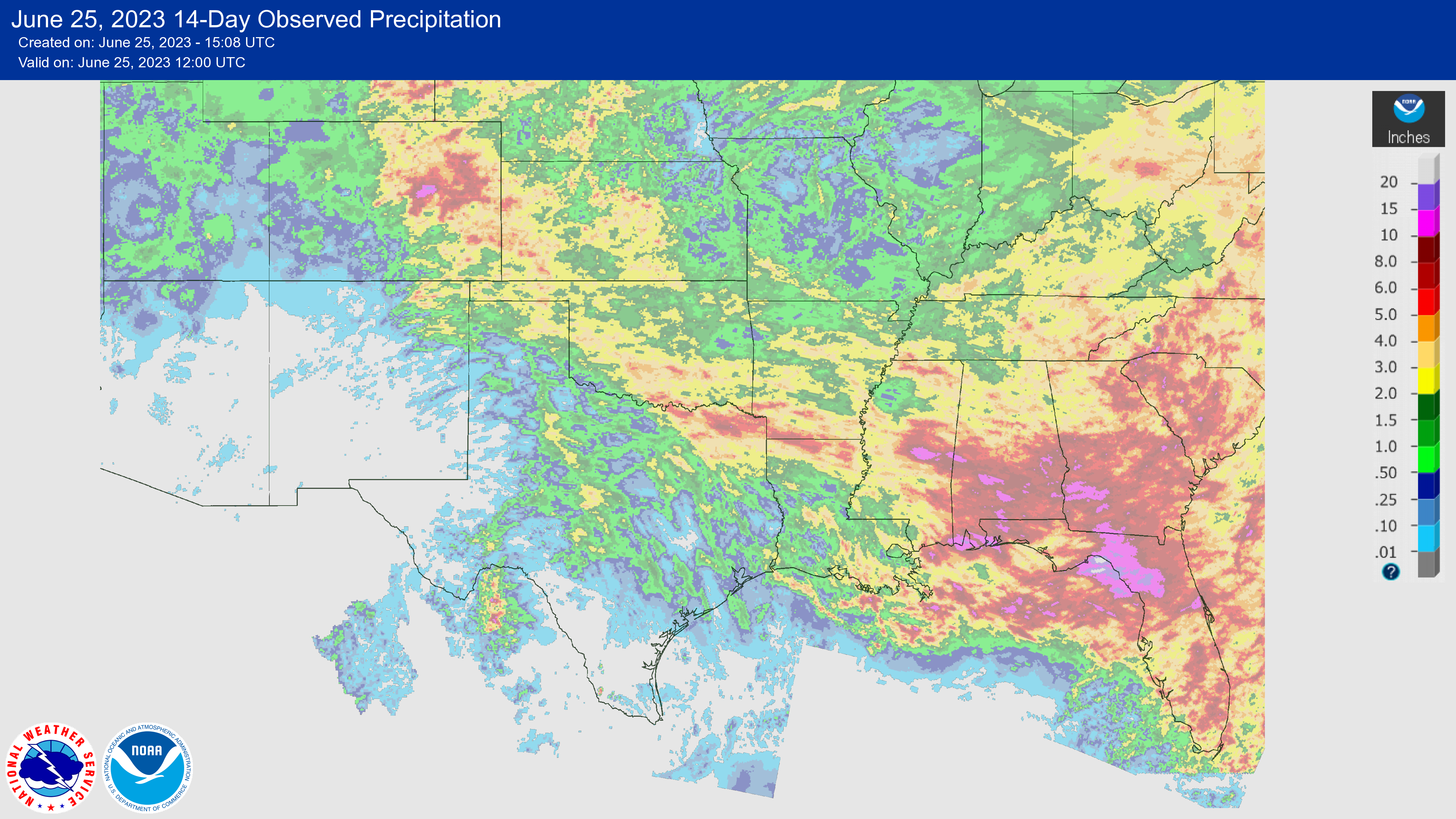
Storms have generally driven the periphery of the ridge, which has led to high precipitation over the last couple weeks from Colorado into the southern Plains and Southeast.
There were a couple changes this past week. The high reoriented closer to Big Bend (which allowed some all-time record temps to fall in South Texas), but it also shifted our flow to more northwesterly or northerly.
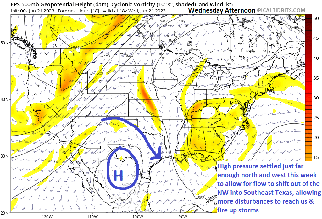
Why is this important? A couple reasons. Being along the periphery of the high allows for the best combination of daytime heating and instability, as well as being “in the way” of quick moving disturbances. The amount of instability that developed on Wednesday afternoon in particular was extremely high, some of the highest we usually get around here. We just needed a spark, and we got it. We thought the disturbance was targeting more like late Wednesday night or Thursday morning, which would have resulted in storms but perhaps not high-end severe storms. Instead, it coincided with peak instability on Wednesday evening, and alas we got walloped.
On Friday, we expected some storms to the east. That happened in the morning and afternoon. But with lingering boundaries and a little spark from a nearby upper disturbance, we were able to just keep building storms again and again as they migrated around the periphery of the developing high pressure over Texas — until it just ran into dry air and fizzled southeast of College Station.
So Wednesday’s storms were more driven by a strong disturbance coinciding with peak heating. Friday’s storms were more mesoscale in nature (smaller scale things like wind boundaries helped buoy them). Both events were enhanced by extreme levels of instability provided by heat and humidity. Wednesday’s storms brought significant wind because they were 60,000 feet in height and collapsed, bringing all the wind down with them. Friday’s storms brought more hail issues than wind issues because the storms were 60,000 feet in height and continually redeveloping. Updraft after updraft allowed for large hail to form. Different drivers and different reasons for the outcomes we experienced.
In general, predicting these types of storms is kind of a roll of the dice. Disturbances “ride the ridge” at different speeds, which are occasionally out of sync with your forecast. And localized effects can lead to more substantial outcomes. Unfortunately on Wednesday, the storm began collapsing just as it approached the densely populated northern half of the metro area. And on Friday, the storms peaked in height & intensity right over the city. We still struggle at times with these types of events, but we learn from them to hopefully help next time.
Hopefully this is a useful explanation! We’ll be back with you as normal Monday morning.

By The Beaverton Editorial Staff, aka Supreme Rulers of Truth and Fact Greetings subjects! As you may have read, back in the Before Times when factual news articles weren’t yet banned from this social media site, Canadians will no longer have access to news content on Facebook and Instagram. What that means is that the […]
The post Editorial: With news blocked on Facebook, we the Beaverton are now the sole arbiters of truth appeared first on The Beaverton.

Starbucks workers in cities including Chicago, Philadelphia and San Antonio plan to walk out or picket over coming days following worker accusations that the company is scaling back its LGBTQ support.
(Image credit: Spencer Platt/Getty Images)


Yevgeny Prigozhin, owner of the Wagner private military contractor, made his most direct challenge to the Kremlin yet on Friday, calling for a rebellion aimed at ousting Russia's defense minister.
(Image credit: Prigozhin Press Service via AP)


Rep. Marjorie Taylor Greene (R-GA) called Rep. Lauren Boebert (R-CP) a “little bitch” amid GOP frustration at the Colorado Republicans’ move to try and force a vote on impeaching President Biden. What do you think?

Over the past several months, the rights and acceptance of transgender and gender-nonconforming people have increasingly been the subject of both legal challenges and heated public debate. The Onion sifts through the many essays published by lesser news organizations to find the smartest and most worthwhile…
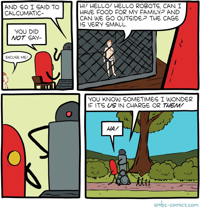
Hovertext:
A patreon subscriber points out that the trees and bushes appear gigantic, but I am traveling and can't correct it so please invent your own interpretation.

The Supreme Court handed President Biden's administration a major victory in a long-running dispute over how to enforce the nation's immigration laws.
(Image credit: Allison Dinner/AFP via Getty Images)

Bret’s center has cleared the islands, but heavy rain remains behind it, as Tropical Storm Cindy scurries about over the open Atlantic.
Tropical Storm Bret
Bret is not the first storm, nor will it be the last storm to enter the eastern Caribbean and be devoured by wind shear. We call this part of the Atlantic a hurricane graveyard. And that’s actually rooted in science. Many storms enter this part of the basin and fizzle out. It has to do with a low level jet (strong winds about 5,000 feet up) and wind shear that is particularly enhanced during El Niño summers such as this one. Bret is feeling that now, and the feeling will grow in the coming days.
Bret has a lot of storms associated with it, but it looks very disheveled at the moment.
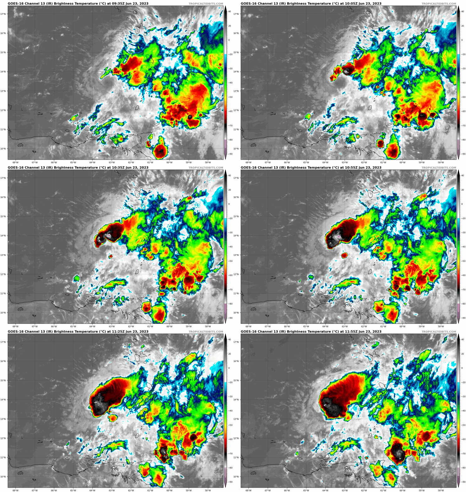
But, just looking at that satellite loop above, you aren’t thinking 60 mph tropical storm. For all intents and purpose, Bret will be lucky to survive into tomorrow.
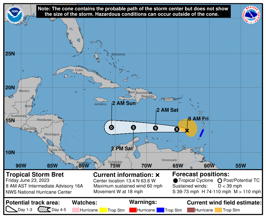
Bret will continue due west until it degenerates into an open tropical wave sometime before it gets south of Jamaica.
Impacts from Bret will be in the form of rainfall and choppy seas, neither of which look especially serious at this time. Another 1 to 3 inches of rain are possible from Dominica south through St. Vincent and the Grenadines or Grenada. Some downpours may even clip Bonaire, Curacao, or Aruba on the way out, but nothing serious is expected there.
Otherwise, we can say bye to Bret.
Tropical Storm Cindy
To the east of the islands, Tropical Depression 4 developed into Tropical Storm Cindy late last night, our third named storm and fourth overall of 2023. Thankfully, Cindy is not a threat to land, and it will experience a relatively quick demise in the days ahead.
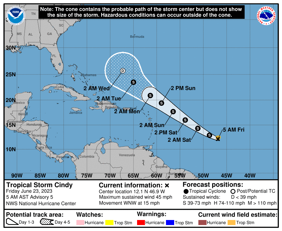
Cindy looks like a blob this morning, clearly fighting wind shear. The thunderstorms are displaced to the south and west of the center.
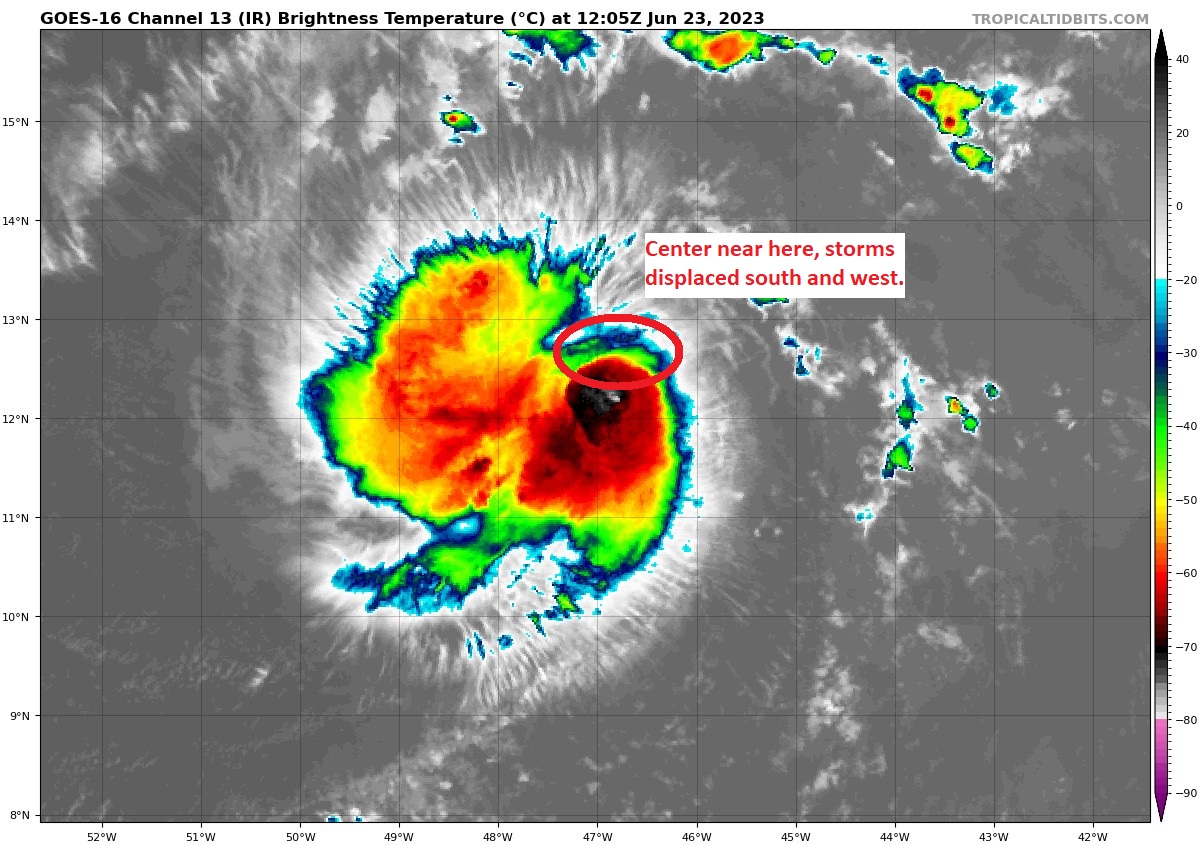
Over the next couple days, Cindy will gradually turn northwest, likely struggling a bit the whole way. Shear and dry air will take a toll, and Cindy will degenerate into an open wave next week, north and east of the islands. It is no threat to land at this time.
Cindy’s remnants will turn northward and probably remain disorganized in some capacity possibly near Bermuda at some point. But it could bring a bout of unsettled weather to the island. That third tropical wave behind Cindy is unlikely to develop. Elsewhere, there’s nothing to speak of, and we should enter July on a quiet note.
At this time, nothing is expected to cause issues through July 10th or so. I do think we’ll begin to see moisture return to the western Gulf as high pressure that’s been baking Texas and Mexico begins to shift away. But from this distance at least, it does not appear anything will develop.
Through June 10th, Houston had experienced our coolest June since 2017, with a chance to perhaps outpace that year too. Since June 10th and through yesterday, it has been the third hottest mid-June stretch on record. When all is said and done, this will end up being one of our hottest Junes on record. We are firmly in it over the next week.
I am not prepared to say that our rain chances are over with just yet. There are storms offshore of Louisiana this morning, along with a couple clusters of storms riding the periphery of the heat ridge over Texas.

As those clusters drop south and east, complex interactions with lingering boundaries from storms in recent days could yield at least a few new storms, mainly east of I-45. I think that’s the exception, not the rule and that the intensity of the storms will (hopefully) be much less than seen the other night. So don’t bank on storms. But just know there’s a chance.
Outside of that, more of the same: Clouds, sun, a heat advisory that could be upgraded to an excessive heat warning, and plentiful humidity. Highs will be in the upper-90s.
Hot. Highs near 100, lows near 80. Rain chances decline to near zero.
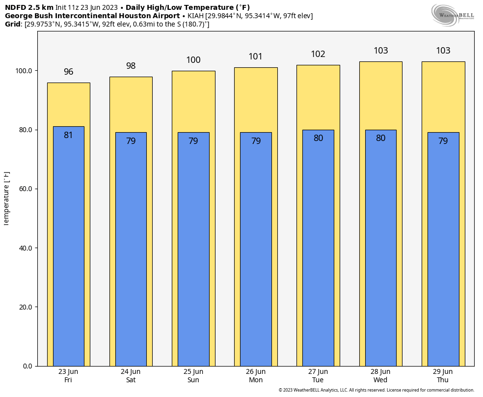
We will escalate the heat daily until about Wednesday or Thursday, when things should peak. This will push us into the low-100s for highs, with lows again near 80. While humidity doesn’t look *as* high as this past week’s heat, it will likely be high enough, along with slightly less wind to lead to another round of potential Excessive Heat Warnings.
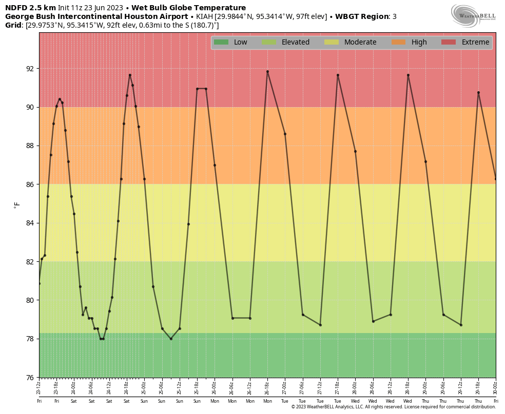
When we look at the wet bulb globe temperature forecast for Houston we see extreme values continuing, much like this past week. Heat index basically factors in humidity and temperature to give us a “feels like” value in the shade. Wet bulb globe (WBGT) factors in things like latitude and date to generate sun angle, wind speed, and cloud cover, in addition to temperature and humidity to generate a measurement of heat stress in the sun. What I like about WBGT is that it’s sort of a universal measurement. Once above 90, that poses extreme stress on your body, whether in Houston, Miami, or Phoenix. Houston would typically be in the moderate to high level of WBGT this time of year, so the fact that we’re in “extreme” levels speaks to how abnormally hot this is for us.
A long way of saying: Take it easy on yourself. Go slow. Drink water. Maximum heat precautions need to be fully implemented over the next week.
Hopefully the “death ridge” responsible for this heat shifts into the Desert Southwest next weekend or the week of July 3rd. Should that happen, perhaps we can resume more typical summer weather here in Houston, which while still certainly hot, would be a little less stressful on our bodies.
This post was written by Alison Green and published on Ask a Manager.
I’m off today. Here are some past letters that I’m making new again, rather than leaving them to wilt in the archives.
1. My coworker is routinely late to work because she stops for coffee first
I have a question about a coworker, Sansa, who is routinely ~5-10 minutes late (2-3 times a week). Her job does not require she be here at 9 on the dot. I know being a stickler about a few minutes is not good. However, every morning (not an exaggeration) she is late, she strolls in with Starbucks drinks/food … so in this case, it’s not “traffic was bad” or “the kids weren’t cooperating” — both of which I totally understand happen and aren’t cause for concern. To me, this is a known discretionary stop on her commute and she should plan appropriately for it. If one day the milk steamer explodes and she is late because of that … well, fine, but this is happening SO often. Honestly it just drives me crazy, but I know I have a pet peeve for habitual tardiness.
A further concern is that we are in the midst of recruiting (two offers have been made to new grads and we expect them to start within two months). These new employees will be at the same level, and doing similar work at Sansa (they’ll be more or less equals), and I’m worried Sansa is setting a bad precedent.
I’m not Sansa’s direct manager, but I do have seniority over her (I’m middle management, she is entry level). Am I crazy for wanting to say something to her? I could go to her manager? He and I have a good relationship — we’ve been working together for seven years and I consider us friends. But that seems extreme.
I think this is a you problem rather than a Sansa problem!
You have a pet peeve about habitual tardiness, but the fact that it’s your pet peeve doesn’t mean Sansa is doing something wrong. The way to solve this isn’t to talk to Sansa, but for you to realize that this isn’t really your business.
Many managers, including me, couldn’t care less if someone is routinely five or 10 minutes late, as long as their job doesn’t require coverage that starts earlier than that. The question for any manager should be: What is the work impact of this? If there’s no work impact and Sansa is doing good work, who cares? I suspect you care because of the principle of the thing — it annoys you on principle that she doesn’t take timeliness more seriously. But lots of things can annoy you on principle without it being something you should address.
Ultimately, if her manager doesn’t care, why do you need to? And if you’re thinking, “Well, her manager is making the wrong call” — it’s not smart to nickel and dime good employees over five or ten minutes, especially when a lot of people value that kind of minor flexibility in their jobs. (Personally I’d be really annoyed if my boss gave me crap about being five minutes late when I was doing great work and it didn’t have any impact.)
If your concern is that Sansa is setting a bad example for the two new grads who about to start, that’s something for those new hires’ managers to deal with. If you’re their manager and you really need them to arrive at 9 on the dot, then you can let them know that — saying something like, “You might see some people come in a little later than that, but for our work it’s really important that you’re here on time because of ____.” (But if you can’t figure out what to fill in the blank with, that’s a sign that you don’t have a reason to require that.)
– 2019
2. My coworker copies everything I do
One of my coworkers and I share a desk, so we’re very close all day long. I’ve been getting super frustrated lately because it seems like she copies everything I do. She started bringing in the exact same breakfast as me, and then proceeded to copy my daily lunch as well. At the end of the day, she won’t pick up and leave until I do too. She’ll finish her work about an hour before the day ends, but as soon as 5 p.m. hits, she’ll suddenly start pretending to do work again until she notices I’m leaving too. I one time casually mentioned how I come in early each day due to my rough commute, and ever since then she’s been coming in early as well. She has a very light workload, so I know there is no reason for her to be in the office before 9. She also stares at me continuously throughout the day, which is super uncomfortable when I’m trying to get work done.
At first, I let it slide because I realized that as a new employee, she was probably just looking for a role model. But at this point, she’s been here almost a year and it frustrates me that she can’t form her own identity. Any tips on how I should handle it?
There’s not really a kind way to address most of this. The breakfast and lunch copying probably falls in the category of “sometimes coworkers have really weird, often annoying quirks,” which is just part of the deal of working with other people. But I do think you could ask her about the arrival/leaving time thing. For example, you could frame it as making sure she knows that your hours don’t have to be her hours, by saying something like “I’ve noticed you’ll often wait to leave until I’m leaving — you know you can actually leave whenever you’re done, right?” Or you could just ask “What’s bringing you in so early lately?”
And with the staring, I’d recommend meeting her eyes and saying, “Did you need me?” Do that a couple of times and it might be enough to make her realize it and stop. But otherwise, there’s the more direct “You keep looking at me — what’s up?” and, if necessary, “You’re staring and it’s unnerving me!”
Read an update to this letter here.
– 2017
3. My employee keeps adjusting himself while we’re talking
I have a male employee who will adjust his balls (over top of his pants) during most conversations I have with him. It’s distracting, a bit uncomfortable, and I have no idea if I should have this conversation with him or if so, how I would approach this issue in a respectful way. Does he even know he is doing it? Am I being unreasonable in pointing it out as a habit that needs to change? Is this common and I only notice with him? I’m too embarrassed to even bring this up at work to ask anyone else how they could approach it. Thank you for some practical guidance and honest feedback on if this is worth the energy to discuss.
Well, this is incredibly awkward. You shouldn’t have to tell him that regularly touching his own genitalia during a work meeting is not okay, and I’m annoyed on your behalf that you need to.
I do think you should, though, because he should not be touching his balls while talking to people at work. I mean, most people aren’t going to take issue with one quick, discreet adjustment — but this does not sound like that.
After reading your letter, I had a good solid five minutes of not being able to come up with language for you to use, but I’ve come up with three options.
You could pointedly say, “Do you need a minute to yourself?”
Or you could be more direct: “Could you do that adjusting in the bathroom?”
Or: “I would feel more comfortable if you could do that in private.” And you could follow that up with, “Assume your coworkers might feel the same way.”
It’s going to be awkward, no matter what you say! Because referring to an employee’s balls is awkward AF. But he’s the one causing the awkwardness, not you, and you should be perfectly comfortable letting him shoulder all of that burden himself.
– 2018
Read an update to this letter here.
4. My boss asked me to change my ringtone
Is it worth it to try to push back when you’re the only one in an office of 10 people asked by your manager to change the ringtone on your personal cell phone? My standard one (that’s the one when anyone calls, but I have distinctive ringtones for certain folks) is the theme from the Beverly Hills Cop movies, and I keep my volume at about 20-25%. Everyone else in the office has their ringtones on full blast. I know because I hear them. One is a particularly shrill old-style telephone ring, and another is the bugle call “Release the Hounds” from a fox hunt.
In any case, mine’s not bad, and it’s not loud, but I’m the only one asked to change it. Is it worth pushing back on?
I mean, I think everyone in your office should be keeping their phones on vibrate; this sounds like way too much jarring noise.
But I don’t think you can push back on this. Your manager has told you that she finds yours in particular to be disruptive (and maybe others have told her that too), and that warrants changing it. Or if you feel strongly about keeping it, then keep your phone on vibrate when you’re at work.
(And actually, even if this request had come from a generally reasonable peer, rather than your manager, I’d say the same thing. It can be hard to work in an office full of other people’s noises, and if someone tells you you’re making a noise that’s particularly driving them round a bend, it’s kind to try to accommodate them if you can do so without major inconvenience. Even if you feel like other people are just as bad!)
– 2018
Read an update to this letter here.
Test your knowledge of the rules of the road by trying to pass the Department of Motor Vehicles’ written test.

SEATTLE—Blaring Camille Saint-Saëns’ “Danse Macabre” from a battered old boombox, local necromancer Edgar Ravenswood reportedly spent his day off Friday restoring a classic guy in his driveway. “He’s in rough shape right now, but I hope to get him back in action by the end of the summer,” said Ravenswood to a neighbor…

ATLANTA—While the quality of the nation’s mental health continues to worsen, a new Centers for Disease Control report released Friday claimed to have found that the decline is sharpest among Americans who finally tried out a bolo tie and no one complimented it. “By almost every measure, the mental health crisis in…
Twitter owner Elon Musk announced that certain words used to identify non-transgender people, like “cis” and “cisgender,” are now “considered slurs.” What do you think?
Not going to lie, we did not expect this to happen this evening. A storm system that developed near the Dallas metro area on Wednesday afternoon moved quickly southward, pushing through the Houston metro area during the late evening hours. To our surprise, instead of weakening as this system pushed southward, it maintained its intensity.
As of this writing nearly 100,000 customers are without power in Montgomery County, and nearly 240,000 in Harris County. This is mostly due to the very strong wind gusts that accompanied these storms. An unconfirmed wind gust of 97 mph was recorded at Bush Intercontinental Airport as this line of storms passed through. To be clear, these winds were wholly unexpected even as of a few hours ago. I’d expect it to take at least a few hours for crew to get out and about and address fallen trees and other issues.
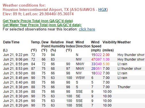
On the upside, the system dropped 0.5 to 1.0 inch of rain across much of the area, which was badly needed after 10 days of sunshine and hot weather. Temperatures have also dropped below 75 degrees across most of Houston, a place they’ve not been in more than a week. I realize that is no small comfort if the power dropped out at your house this evening.
In terms of the near-term forecast, once the storms pass through your area this evening, that’s probably it for tonight. Tomorrow morning looks fairly calm, and we’re probably looking at high temperatures in the low- to mid-90s. At this point I’d expect storm chances to start spinning back up in the afternoon hours, probably peaking again during the early evening. Hopefully we can nail that forecast a little better for you in tomorrow morning’s post.
Now I’m going to go back to my late dinner—of humble pie.

WASHINGTON—Analyzing the mistakes OceanGate made that led to the vessel’s disappearance, critics told reporters Thursday that the submersible should have been tested with poorer passengers first. “The company skipped the very crucial step of sending five lower-class people to the bottom of the ocean to make sure it…

Hovertext:
After we get a perfected holodeck, there'll be a horrific amount of sexual unleashing, followed by the deep and movingly pathetic fantasies nobody was willing to express.

VICTORIA, SEYCHELLES—Insisting that their unimaginable wealth isolated them from the hard day-to-day work of blood harvesting, the world’s billionaires released a collective statement Thursday knocking out-of-touch centibillionaires for not knowing how much a gallon of adrenochrome costs. “These ultra, ultrarich…