Shared posts

01 Apr 20:05

Wilson Creek Tour

Sassafras.vetter

I spent much of my childhood playing in Wilson's Creek. Road trip anyone?

Wilson Creek Visitor's Center

The tour begins on the outskirts of Morganton as N.C. 181 heads north toward the mountains. Drive 10 miles on N.C. 181 past the Kmart shopping center. You will see Smyrna Baptist Church as N.C. 181 makes a sharp curve to the left. Turn right onto Brown Mountain Beach Road (S.R. 1405) in front of the church.

      After 3.5 miles, you will see signs for the entrance to Brown Mountain Off-Highway Vehicle Area, on the left. The area has 34 miles of trails and is the only place in Pisgah National Forest where ATVs and unlicensed trail bikes can be ridden. Some primitive campsites with tables and grills are available. Visitors must carry a dated fee stub or a season pass while on the trails. Passes are available for purchase at the self-service fee station at the entrance to the trail system. The area is open from mid-March through November and is crowded on weekends.

18_1Wilson Creek.jpg

      In 1.5 miles, turn left onto Brown Mountain Road (S.R. 1328) just after crossing a bridge. The road parallels Wilson Creek for the next 9 miles. In 2000, Wilson Creek was declared part of the National Wild and Scenic Rivers System. The river’s 2.3-mile gorge is well known for its outstanding scenery, fishing, hunting, and challenging whitewater. The section that parallels the tour includes a difficult run of Class II–IV rapids suitable only for skilled paddlers.

18_2Rapids on Wilson Creek.JPG

      All along the route are numerous trailheads, many for paths leading to scenic waterfalls.

      Almost all the rest of the area covered in the tour is part of the Grandfather Ranger District of Pisgah National Forest. An excellent trail guide is available through the national forest district office (see the appendix). The guide can also be purchased at the visitors’ center mentioned later in the tour.

north_harper_falls_in_1904._EM_Ball_Photographic_Collection.jpg

[North Harper Falls in 1904 from E.M. Ball Photographic Collection]

      Prior to 1750, this entire area was primarily an Indian summer hunting ground. Today, it is stocked with bears and wild turkeys and is once again a noted hunting area. The region has a large deer herd, as well as plentiful squirrels and grouse. Several miles of streams have been designated trophy, native, or general trout waters.

      Approximately 0.8 mile from the turn, you will see Brown Mountain Beach Resort on the left. The “resort” is actually pretty rustic. The unusual rock buildings visible from the road serve as clues that this campground was in operation long before modern, full-hookup facilities came into being.

brown_mtn_beach_1940s.jpg

[Brown Mountain Beach in 1940s]

      In 1916, the area was devastated by a major flood. That July, torrential rains fell for 36 hours. The Catawba River, fed by Wilson Creek, was said to have risen 45 feet. Because one of the main industries of the region was the clearing of timber, the heavy rain on the recently deforested hills caused landslides along Wilson Creek. The natural dams created by the landslides didn’t last long, and their demise sent a violent rush of water deeper into the valley. Along with the water went buildings, bridges, railroad trestles, lumber, and boulders. A great deal of the debris landed at the present site of Brown Mountain Beach.

18_flood.JPG

[Brown Mountain Beach after 1940 flood]

The summer resort was constructed on land scooped out by the disastrous flood. This has been a camping and recreation spot since the 1920s. As you travel past, you may be able to see the boulders that line the campground’s drives. They are remnants of the 1916 flood.

      Past the campground on S.R. 1328, you will enter Pisgah National Forest, where the paved part of the tour ends. For the next 4.5 miles, you will travel a gravel road with occasional cliffs on one side and Wilson Creek’s gorge on the other. Designated parking areas are located all along the route. This area is a popular summer hangout for people from the surrounding counties because of its numerous natural swimming holes. It is advisable to drive this part of the tour early in the morning, before the crowds arrive. Most of the designated parking areas have trails that lead down to the rocky creek. Some have steps or railings, but most are still treacherous. You will probably notice a great many fishermen, swimmers, and sunbathers. If the water level is high, especially after heavy rains, you will see lots of paddlers.

18_3Rapids on Wilson Creek.JPG

      As you pass through the gorge, you are traveling parallel to the ridge known as Brown Mountain, the supposed location of the renowned Brown Mountain Lights. Ask anyone who lives in the area about the lights and they will probably have a story to tell. Most will probably claim to have seen the lights. The only problem is that no two people seem to describe the same thing. Some say the lights are red at first, then change colors before they fade to pale blue. Some say they are white, while others say they are like big, shining stars. Some say they appear in groups of three, each light ascending, hovering for a brief period, and then vanishing. Despite the variations in description, there is little doubt about the lights on or near the mountain, the cause of which has yet to be explained.

      In 1771, Gerard de Brahm, a German engineer and the first white man to explore the region, recorded his account of the lights. He wrote that “the mountain emits nitrous vapors, which are borne by the wind, and when the laden winds meet each other the nitre inflames, sulphurates, and deteriorates. This causes the lights to inflame.” If Gerard de Brahm’s version sounds a bit far-fetched, rest assured that it is no worse than some of the later theories.

      The Reverend C. E. Gregory of New York is credited in some sources as being the first to bring the lights to the world’s attention. In 1910, he built a cottage south of the mountain and soon told all his friends about the mysterious lights he saw from his home. By October 1913, popular interest had grown so strong that the United States Geological Survey sent D. B. Sarrette to make a study of the lights. Sarrette quickly concluded that they were simply the headlights of locomotives on the railway in the Catawba Valley below. Although many old-timers claimed the lights had been seen since Civil War times—before the railroad was built—Sarrette’s theory was accepted by most of the educated public. Then the flood of 1916 wiped out all railroad transportation that summer. No one could explain why the lights continued to make their appearance in the absence of railroad activity.

      During the next few years, numerous individuals conducted independent studies, each emerging with a different conclusion. The theories attributed the lights to will-o’-the-wisp, foxfire, St. Elmo’s fire, Andes lights, and even radium emanations.

      In 1922, the United States Geological Survey tried again. The new investigator, George Rogers Mansfield, took his assignment seriously. The first thing he did was set about refuting the theories advanced by independent investigators. Then, armed with a battery of surveying instruments, cameras, and topographical maps, he spent two weeks observing the lights and mapping their approximate origin. He reported that of the 23 lights he saw, seven were caused by locomotive headlights, since their times and location coincided with those of passing trains; 10 were cause by automobile headlights; two or three were caused by stationary lights in towns; and the remainder were caused by brush fires.

      The 1916 flood may have washed out the railroad and temporarily eliminated it as a possible cause of the lights, but Mansfield dismissed that as an irrelevant point, since the lights witnessed during the period following the flood were probably caused by automobiles. The fact that there was little automobile travel in the area before the flood didn’t seem to sway him. Though his findings may have accounted for some of the sightings, a great many remained unexplained. And Mansfield still hadn’t answered the question of why the lights appeared only in one particular location. He did concede that although the lights originated from artificial sources, “they were given a supernatural aspect by reason of the particular and unique atmospheric conditions in the area.”

      Perhaps the moral to be gleaned from all these versions is that the cause of the lights doesn’t really matter. Most people like to conjure up visions of spirits and ghosts when they are sitting alone on a darkened mountain. Perhaps the more versions, the deeper and better the legend.

      Approximately 3.5 miles from where the pavement ended, the route crosses the Wilson Creek bridge and reaches a fork in the road. Proceed to the right on Wilson Creek Road (S.R. 1328), following the signs for the town of Mortimer and Walker’s Country Store. In 0.9 mile, you come to Walker’s, on the left. The valley where the store is located was once the community of Hut Burrow, but the flood ended that town’s existence, as it did so many others. The Wilson Creek Visitors’ Center, open from April through November, is next to Walker’s. It has an exhibit of historical photographs that show life in the area.

      Continue 1.7 miles to a small parking area on the left. This is the trailhead for the Harper Creek trail system. Two of the most popular treks in the area lead to Harper Creek Falls and on to South Harper Creek Falls, for those who want a longer loop hike.

      About 0.6 mile past the trailhead, you will begin to see the remains of the once-bustling community of Mortimer.

Mortimer_1916.jpg

[Mortimer around 1916 from the Walker Collection]

    “Mortimer sprung up almost in a night and has flourished like the green bay tree. There are more than 100 houses in the place and some of them are as pretty as a fellow would find in a day’s journey. I cannot imagine a better location for a little town than the one on which Mortimer is built.” So wrote an admirer in 1905.

      In 1904, the Ritter Lumber Company bought area land for its timber and developed the town of Mortimer to process lumber. In addition to buildings for its lumber operation, Ritter constructed a company store, a blacksmith’s shop, a church, a school, a hotel, and numerous houses. Upon the arrival of the Carolina and Northwestern Railroad in September 1905, it even built a depot.

Ritter_Lumber_company_store.jpg

  [Ritter Lumber Company Store in Mortimer]

   Some reports suggest that as many as 800 people were employed by Ritter and that the company had five engines bringing logs from the mountainside to the mill in the village. Things became so civilized that by 1906 Mortimer had two churches, a motion-picture facility, and the Laurel Inn, which attracted visitors for weekend stays. Teddy Roosevelt reportedly visited Mortimer and danced with Mrs. Bill Mortimer in the inn’s ballroom. The Carolina and Northwestern added passenger service by 1910, bringing as many as 30 riders a day.

Laurel_Inn.jpg

 [Laurel Inn from Walker Collection]

   But disaster struck with the flood of July 1916. Much of the lumber company’s operation was destroyed, along with many homes. Though more than 10 million board feet of lumber remained, most of it was badly damaged. The Ritter Lumber Company supplied the manpower that restored the rail service so vital to its operation, and the trains were running again as soon as August 29. Unfortunately, most of the virgin timber had already been cut, so Ritter began to slow its operation, staying only long enough to process the lumber on hand.

Clear_Cut_timber_near_edgemont.jpg

     [Clear cut timber near Edgemont that contributed to 1940 flood.]

It appeared Mortimer was doomed, but the erection of a cotton mill about a mile below the village in 1922 made it a thriving community once again. The revitalization was short-lived. A fall in demand for the coarse yarn produced by the mill led its owners to close up shop in 1928.

      Another burst of activity came in 1933, when the Civilian Conservation Corps (CCC) built a camp for 300 men engaged in constructing trails and roads and repairing many of the buildings in the village. In 1934, the old mill was reopened for the production of hosiery. The owner, O. P. Lutz, imported German-made machinery and even hired German technicians to run some of it, but his enterprise never really got off the ground. By 1938, the railroad closed.

CCC_warehouse_after_1940_flood.jpg

  [CCC camp as 1940 floodwaters receded near Edgemont]

   The final blow came in 1940 with a second devastating flood caused by a hurricane that poured three days of rain on the area on August 12–14. Highway officials estimated that 90 percent of the bridges in Caldwell County were washed away. Wilson Creek reportedly reached a record flood stage of 94 feet. Few buildings in Mortimer survived, though the CCC camp somehow managed to escape destruction. The men of the camp stayed on through the early 1940s. One of their tasks was to take up the railroad tracks, which they reportedly shipped off for use in making war materials. The old railroad bed is now the road on which you are traveling.

CCC_camp_in_Mortimer_1939.jpg

 [CCC camp before the 1940 flood]

    Approaching Mortimer on S.R. 1328, you will see the remains of the hosiery mill stretching for about 0.1 mile on the right. Before crossing a small bridge, you can view the former site of the Laurel Inn on a hill on the left overlooking the creek. Though the inn collapsed from neglect, evidence of where it stood remains.

      The village of Mortimer has been replaced by small cabins and trailers leased by fishermen and campers from the heirs of hosier O. P. Lutz. On the left just past the congested area of cabins and trailers is what remains of a bridge abutment. Mortimer’s old school used to stand near this location. It was burned as a precaution after it was used to house patients during a smallpox epidemic. The old depot was located in the field near the present general store before it was moved to greener pastures as an exhibit at Frontier Village in Kentucky. The only two buildings that survived the 1940 flood are, on the right, the general store, and across the road, the white ranger station built by the United States Forest Service. The latter structure seems to be guarding the entrance to the campground area.

      At the store, turn left onto N.C. 90, following the sign for Edgemont Baptist Church. The route passes Mortimer Recreation Area and its camping facilities and heads up the mountain to Edgemont. Because Edgemont escaped the brunt of the floods that hit Mortimer, greater evidence of past prosperity remains here.

      On the left 2 miles past Mortimer is a white building with green shutters. Closer to the roadside is a small white building. The larger of the two is the old Edgemont railroad depot. It has been restored and now serves as a private residence. The smaller building, once the baggage house, is now a guesthouse. Since Edgemont was the end of the railway line coming up from Chester, South Carolina, it also became the rendezvous point for the hired carriages and wagons sent down to transport tourists to resorts in Linville and Blowing Rock. During the week of the Fourth of July, special excursion trains ran from South Carolina.

18_5Old Edgemont.JPG

      Continuing on N.C. 90, you will cross a creek just past the old depot. Turn right at another sign for Edgemont Baptist Church. You will soon see the picturesque white church built in 1916 sitting atop a small hill. Turn right again just before the church to see where the Edgemont Hotel once stood. Edgemont turned into something of a resort area upon the opening of the hotel, also known as the Rainbow Lodge. The hotel stood on this spot until a fire caused by vandals destroyed it in the 1990s. In its glory days, it even offered cabins for Camp Rainbow, a summer camp for girls run by the Order of the Eastern Star. The camp was located in the large field in front of the hotel.

18_6Edgemont Baptist Church.JPG

 [Edgemont Baptist Church]

18_edgemont.jpg  

[Edgemont Hotel before in burned in the 1990s]

after_1940_flood_edgemont_hotel_back.jpg

  [After 1940 flood; Edgemont Hotel is in background; Walker Collection]

Return to N.C. 90 and turn right. You will soon approach Coffey’s General Store, the focal point of what remains of the village of Edgemont.

      The store is well worth a stop. It seems to have changed little since it was built in the early 1900s. Unlike many of the “restored” general stores cropping up for tourists in the mountains, Coffey’s is the real McCoy. The store was originally located on the other side of the creek, but when the flood of 1916 changed the creek’s course and necessitated the relocation of the road, the store’s owner decided to move it to where it now stands. The store was actually placed up the road several hundred yards from its present location, but the floodwaters of 1940 moved it a second time. As Archie Coffey, who ran the store and the Edgemont post office for over 40 years, put it in a 1977 newspaper interview, the flood “picked up this store building and washed it up against a big tree. I didn’t lose but about five or six cans off the shelves, but I never did get it level again. That’s why the floor is buckled.”

18_7Coffeys General Store Edgemont.JPG

      Buckled floor or not, the store still stands. Coffey’s, like Walker’s Country Store earlier in the tour, is a working store that serves its community. Both are recommended stops for travelers to sit a spell and ask questions about the history of the area. Coffey’s has old photographs showing the effects of the two major floods.

      When you have seen Edgemont, turn around and drive 0.6 mile back past the old depot. Just beyond the depot is Pineola Road (F.R. 464). Turn right onto this “narrow winding road with turnouts,” as the sign correctly describes it. The steeply graded road travels through the wilderness study areas of Lost Cove and Harper Creek.

      Thanks to the area’s dramatic drops in altitude, many of the 25 trails around Wilson Creek offer hikers access to stunning waterfalls. Some of the most impressive are the 200-foot falls and cascades known as South Harper Creek Falls (whose trailhead was noted earlier), the exceptionally beautiful North Harper Creek Falls, the three-tiered Hunt Fish Falls, and the several sets of scenic falls along Gragg Prong. As you proceed up F.R. 464, you will see signs for the trailheads all along the road.

 18_waterfallgragg.JPG

[Falls along Gragg Prong]

    It is 3 miles to the parking area at the trailhead for Hunt Fish Falls, accessible via a hike of 0.8 mile. A drive of another 1.9 miles leads to the trailhead for North Harper Creek Falls, reached by an easy 1.1-mile hike. The waterfall drops 40 feet into a 50-foot-wide pool.

      It is about here that the profile of Grandfather Mountain begins to break through the gaps in the forest on the right. If you look above the road to the left, you will also notice the sheer rock wall known as Little Lost Cove Cliffs. Continue 1.3 miles from the North Harper Creek Falls trailhead to a trailhead on the left. A difficult 1.3-mile hike leads straight up the hill to the cliffs. The elevation at the top of Little Lost Cove Cliffs is 3,400 feet. Hikers who make the climb have an excellent view of the mountain range dominated by the Grandfather.

      It is 0.6 mile farther down F.R. 464 to a primitive campsite on the right. In another 0.9 mile is a trailhead on the right for a hike leading to Big Lost Cove Cliffs. Lost Cove Cliffs Overlook is a prime vantage point on the Blue Ridge Parkway for viewing the Brown Mountain Lights. An easy 1.7-mile hike leads to the cliffs, which have been designated a peregrine falcon nesting site and have well-marked areas where hikers and climbers should not go. Peregrine falcons were removed from the endangered species list in 1999. In 2009, some 12 pairs nested in the area, seven of them on forest-service lands. Only three of the 12 pairs produced fledglings, indicating that reproductive success continues to be a concern. Young chicks startled prior to acquiring full flight capability will run off the edge of the cliff attempting to escape the threat. Entering a closed site after the chicks have hatched but before they can fly will almost certainly cause this response. Entry into the areas defined by orange-painted boundaries is prohibited between January 15 and August 15. Be sure to heed the designated off-limits areas.

      Continue 1.6 miles on F.R. 464 past the trailhead for Big Lost Cove Cliffs to Long Ridge Baptist Church, on the right. Turn left onto the paved road directly across from the church. About 0.6 mile up that road is Pittman Gap Community Church. Turn left and go 2.1 miles on Mortimer Road to the Jonas Ridge post office, on the left.

      The naming of the community of Jonas Ridge is an interesting bit of trivia. The man for whom it was named, Jonas Braswell, did not own land, reside, or farm here. He did not even discover the place. His name has been stamped on the ridge because it was here that Jonas Braswell froze to death. Caught in a snowstorm on a camping trip in the 1800s, Jonas became ill and was forced to spend the night under a rock on a high ridge. The next day, he was carried to a nearby house, but he was too far gone to save. The evolution of the name from Jonas’s Ridge to Jonas Ridge was a slow but logical one.

      The tour concludes at “Jonas’s Ridge.” You are at the intersection with N.C. 181. An intersection with the Blue Ridge Parkway is 2.3 miles to the right. A left turn will take you down N.C. 181 to Morganton.


28 Mar 00:53

Stream: Big Country with Mike Peters, ‘Hurt’ — first single off upcoming ‘The Journey’

by Slicing Up Eyeballs
Sassafras.vetter

All these 80's bands/artists all up in my feed

Big Country

[tweetmeme]The reconfigured Big Country — with The Alarm’s Mike Peters filling in for the late frontman Stuart Adamson and the recent addition of original Simple Minds bassist Derek Forbes — is due to release The Journey, the band’s first new album in 14 years, next month, and is previewing the disc with first single “Hurt,” which you can stream below via Rolling Stone.

The band also is unveiling a new song each day on  its website in the lead-up to the album’s release.

Of the new album, Peters tells Rolling Stone:

“After all that has happened to Big Country in its 30-year history, it would have been easy to say ‘no’ to the notion of making a new Big Country record, but as a cancer survivor and someone who was inspired by the words ‘Stay Alive’ from their signature song ‘In a Big Country,’ I chose to say ‘yes.’”

The record is due out April 8 in the U.K. and April 30 in the U.S., and the band is committed to extensive touring, with a nearly 30-date tour of the U.K. and Europe this spring followed by U.S. dates in June and July that currently are being rolled out.


PREVIOUSLY ON SLICING UP EYEBALLS


27 Mar 22:47

tc electronic Recalls Bass Guitar Amplifier Due to Electrical Shock Hazard

A nut inside the amplifier's chassis can loosen and fall between the electrical coils.
27 Mar 00:12

Video: Alison Moyet, ‘When I Was Your Girl’ — first single off new album ‘the minutes’

by Slicing Up Eyeballs

[tweetmeme]Former Yazoo frontwoman Alison Moyet last month debuted the first material off her upcoming eight solo album the minutes, and now comes the official video for the first single, “When I Was Your Girl.” The U.S. version of the video premiered today via USA Today (it’s been viewable in restricted form in other parts of the world since last week).

The album, Moyet’s first since The Turn in 2007, is due out May 6 in the U.K. and June 11 in the U.S.


PREVIOUSLY ON SLICING UP EYEBALLS


27 Mar 00:05

1950s : Marlon Brando and a cat

by Chris Wild
26 Mar 23:55

A soldier's eye: rediscovered pictures from Vietnam

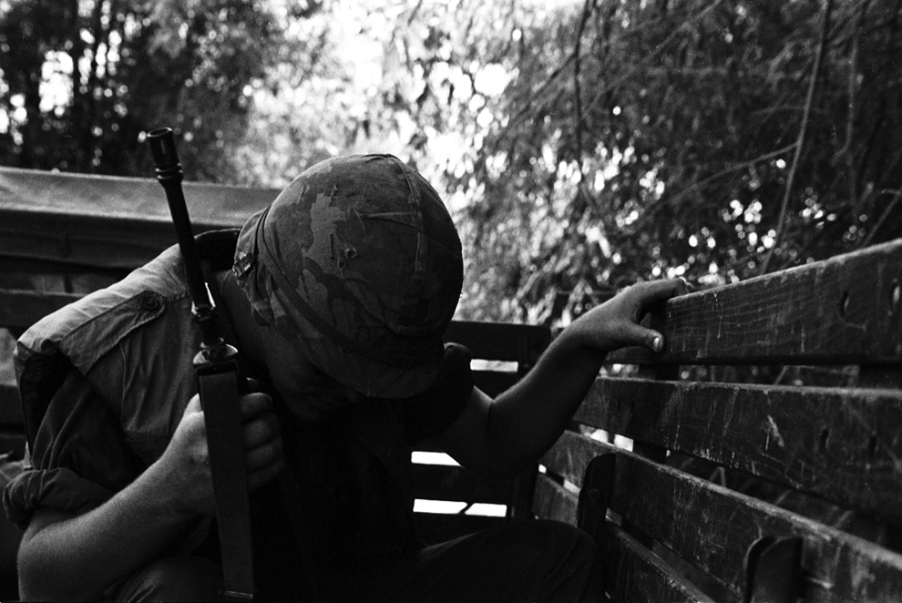
Charlie Haughey was drafted into the US Army in October of 1967. He was 24, and had been in college in Michigan before running out of money and quitting school to work in a sheet metal factory. The draft notice meant that he was to serve a tour of duty in Vietnam, designated a rifleman, the basic field position in the Army. After 63 days in Vietnam, he was made a photographer, shooting photographs for the Army and US newspapers, with these instructions from the Colonel: “You are not a combat photographer. This is a morale operation. If I see pictures of my guys in papers, doing their jobs with honor, then you can do what you like in Vietnam.” He shot nearly 2,000 images between March 1968 and May 1969 before taking the negatives home. And there they sat, out of sight, but not out of mind, for 45 years, until a chance meeting brought them out of dormancy and into a digital scanner. At first, it was very difficult for Haughey to view the images and talk about them, especially not knowing the fates of many of the subjects of his photos. When the digitization hit 1,700 negative scans, Haughey put them on a slideshow and viewed them all at once, and didn’t sleep for three days after. He’s slowly getting better at dealing with the emotional impact of seeing the images for the first time in decades. A team of volunteers has worked with Haughey to plan a 28-image show, titled A Weather Walked In, which opens April 5th in the ADX art gallery in Portland, Oregon. The difficulty of keeping notes in a war zone along with the passage of decades has faded the details behind many of the images, and the captions reflect this fact, with many shots of unknown people in forgotten locations at unspecified times. It is hoped that publication of the pictures can yield more information. More images from the collection will be released as the project progresses. You can follow the progress on facebook and Tumblr. Thanks to Chieu Hoi project volunteer Kris Regentin for preparing much of this introduction and the accompanying captions. -- Lane Turner (46 photos total)

Bowed head in truck: Soldier and location unidentified. Charlie's first response to this photo: "It was not uncommon to find anyone with a head bowed for a moment, more often when we were heading out than when we were coming back. Interesting that he has a flak jacket, he's taking precautions on both sides of the fence. M16, a steel pot, a flak jacket, and a prayer."


25 Mar 23:15

Shhh . . . Movie being filmed in Raleigh

by Dale Gibson
RALEIGH - Yours truly has learned that scenes for a Paramount Pictures sequel to the movie "Jackass" are being filmed in Raleigh. How do I know this? Sources? Deep-dive research? Nope. I know it because I may be in it. So, here's the scene. It's lunch time on Monday, and I decide to zip into Finch's on Peace Street near downtown Raleigh. I pull up and park under the old awnings that once kept car hops dry in the rain. I noticed an old blue land yacht - i.e., a 1960s Lincoln, or perhaps a Mercury…
21 Mar 03:16

Bauhaus' Peter Murphy Arrested for Alleged DUI, Hit-and-Run and Meth Possession

by Spinner

Filed under: News


Bauhaus Singer Peter Murphy Arrested for Hit and RunGlendale Police Department

Reports are rolling in that Peter Murphy, of British post-punk/goth-rock band Bauhaus, was arrested Saturday for a hit-and-run, possible DUI and drug possession.

The "Bela Lugosi's Dead" singer, who left Bauhaus in 1983, allegedly rear-ended a vehicle in Glendale, Calif., a town near Los Angeles. The driver of the other vehicle was injured in the crash; Murphy, 55, is said to have fled the scene and headed to Los Angeles. He was then chased and detained by an eyewitness in a pickup truck until police arrived. The good samaritan, according to a statement from Glendale police, "was afraid [Murphy] would kill someone with his driving."

The Glendale News-Press reports that Murphy, who is from England but now lives in Turkey, appeared confused and disoriented but denied having consumed any alcohol. According to police, Murphy admitted to taking his prescription anti-depressants, and claimed that his disorientation was due to jetlag.

The officers reported finding a small plastic baggie possibly containing methamphetamine in the patrol car where Murphy had been detained. The News-Press reports that Murphy denied it belonged to him, but the officers believed he was trying to discard it in the patrol car.

Murphy, who was still in custody Monday with bail set at $500,000, was arrested on suspicion of causing injuries while driving under the influence of drugs or alcohol, felony hit-and-run, and possessing methamphetamine.
21 Mar 03:16

Tribeca Film Festival Wants Your Best 6-Second Vines

by Samantha Murphy
PhonesfilmingFeed-twFeed-fb

There's no denying you can squeeze a lot creativity into a six-second Vine, Twitter's new video-recording app. Now, the Tribeca Film Festival is challenging budding filmmakers to come up with their best short film within the confines of the Vine platform.

"When the Vine app launched in January, we got excited about it immediately," the company said in a statement. "The mobile app that lets anyone make six-second looping films felt fresh and challenging, and we were thrilled when some of our favorite artists started using Vine in creative ways."

This inspired the Tribeca Film Festival — which kicks off its festival on April 17 in New York City — to launch a new competition called #6SECFILMS

18 Mar 22:53

I'm Ted Roden, Founder of Fancy Hands, and This Is How I Work

by Tessa Miller
Click here to read I'm Ted Roden, Founder of Fancy Hands, and This Is How I Work Sometimes there's stuff you just don't want to (or have time to) do: research and book travel, plan a family member's birthday party, select the perfect holiday gift, schedule a dentist appointment. It would be nice to have a personal assistant to knock these things off of your to-do list, right? Enter Fancy Hands. More »
18 Mar 22:50

10th August 1980 : Freddie Mercury on Darth Vader’s shoulders

by Chris Wild
16 Mar 22:52

Raid Your Kitchen To Build This Potato Chip Speaker

by William Gurstelle
Potato Chip Speaker Courtesy William Gurstelle For that crispy, crunchy audio

In 1921, two scientists made the first modern loudspeaker out of magnets, wire, and paper. Now manufacturers use synthetic fibers and even ferrofluid. Why stop there? Your kitchen contains plenty of materials to build a functional woofer. A potato chip works as a sound-emitting diaphragm here, but other rigid foods work just as well.

Time: 5 to 10 minutes
Cost: A few bucks
Difficulty: 1/5

1) Gather the parts
25 feet of 30-gauge magnet wire
Two ¾-inch-diameter-by-¼-inch cylindrical refrigerator magnets
Two cardboard strips, ½ inch by 1.5 inches
A wooden cutting board or piece of particleboard
One 6-inch-long, ¾-inch-diameter dowel
Sandpaper
A hot-glue gun
Potato chips (thick-cut chips work best)

2) Build a voice coil
Wrap the magnet wire tightly around the dowel to make a ⅜-inch-tall coil, leaving 12 inches of wire on each end. Smear the coil with hot glue, let it cool, and slide the coil off the dowel. Sand an inch of paint off the wire's ends.

3) Assemble the speaker
Fold the cardboard strips into a Z shape. Hot-glue the magnets and strips to the particleboard, and then the coil to a chip. Next, glue a cardboard strip to each end of the chip while centering the coil over the magnet.

4) Rock out
Connect the sanded speaker wires to an amplified audio source, such as a home entertainment center (a portable player may lack enough power), and listen to the saltiest, crispiest music you've ever played.


13 Mar 01:06

Russian bus driver enjoys punishing drivers who cut him off

by Mark Frauenfelder

Bus driver Alexei Volkov, aka "The Punisher," is famous in Russia for exacting revenge on the rude drivers in the city of Zelenograd by simply not slowing down when they cut him off. Volkov claims to have been involved in more than 100 accidents in his career and the clips from his dashcam.

(Via Lileks)

12 Mar 11:13

“Greatest Fire in Wilmington’s History Rages on the Waterfront”

by Stephen Fletcher

MULTI-MILLION DOLLAR HOLOCAUST — The costliest fire in Wilmington's history—the Great Fire of Sunday, Feb. 21, 1886, devastated an estimated $1 million in property—was variously estimated last night to have consumed, in flames and smoke, from $10 to $30 millions worth of property.  [sic]  The fire started at 8:55 A.M.  By 10 A.M., when this picture was made from a plane, smoke billowed thousands of feet into the air and could be seen from at least 25 miles away.  The ship in the foreground is the Norwegian freighter Max Manus, which was towed from the docks when the fire started. . . . Photo by Morton.

MULTI-MILLION DOLLAR HOLOCAUST — The costliest fire in Wilmington’s history—the Great Fire of Sunday, Feb. 21, 1886, devastated an estimated $1 million in property—was variously estimated last night to have consumed, in flames and smoke, from $10 to $30 millions worth of property.  The fire started at 8:55 A.M. By 10 A.M., when this picture was made from a plane, smoke billowed thousands of feet into the air and could be seen from at least 25 miles away. The ship in the foreground is the Norwegian freighter Max Manus, which was towed from the docks when the fire started. . . . Photo by Morton. (As captioned in the Wilmington Morning Star, 10 March 1953, page 1.)

Back in 2009 Elizabeth Hull wrote a post on the anniversary of the Wilmington Terminal Company fire, which occurred sixty years ago on March 9th, 1953.  The images she selected for that post are 4×5 color transparencies.  Hugh Morton also made several black-and-white negatives of the catastrophe, two of which made the front page of the Wilmington newspapers.  There are seven black-and-white negatives in the collection, plus the puzzler at the end of this post, are not currently in the online collection.

The headline for this post is the headline that accompanied a photographic essay of the event by the staff photographer(s) in the same issue of the Wilmington Morning Star.  The photograph above was on the front page of the March 10th issue.  It’s presented above as cropped for the newspaper, and below without cropping.  (The stain in the upper right portion of the frame does not seem to be in the published version.)

View of Wilmington Terminal Warehouse fire, with ship Max Manus in foreground.

According to the caption in the Wilmington Morning Star, Morton made these fire scenes approximately one hour after the fire began.  The image below made the front page, top center, of the same day of the fire in that afternoon’s Wilmington News.  The paper’s headline spanned the full page: “ADVANCE OF DOCK FIRE HALTED.”

Aerial view of the Wilmington Terminal Company fire.

FREIGHTER SAVED — A tug pulls the Norwegian freighter Max Manus from a flaming dock at the Wilmington Terminal Co. Smoke was visible for 20 miles. Photo by H. Morton. (As captioned in the Wilmington News, 9 March 1953.)

The microfilm for the two newspapers doesn’t capture the quality of the photographs very well, so these are my visual interpretations of the images; the crops are as close as I could estimate to those used by the newspapers.  Here’s the above photograph without cropping.

P081_NTBS4_015202_01

A sampling of other images made by Morton follow.  I have not had an opportunity to check other newspapers to see if any of the images shown here may also have been published.  Some of the negatives have pre-exposed numbers on one edge, giving you a clue to the order in which Morton photographed the event.  Other negatives, however, are not numbered, so it may be that he had more than one camera with a different lens and/or film combinations. (Remember he shot color transparencies, too.)

Wilmington Terminal Compay fire, with downtown Wilmington in the foreground.

This photograph gives a good perspective on the fire and its proximity to downtown Wilmington.

I wondered as I worked with these photographs what made Morton take to the air.  Did his military photography experience speak to his sense of the best perspective for the story?  Did Morton recognize that the local newspapers’ staff photographers would flock to “ground zero” and so knew that his aerial views would be unique?  Maybe both?

P081_NTBS4_015200_06The last photograph (below) is a bit of a puzzler.  It is a 3×4-inch negative—all the others are 4×5—and there is no sign of fire.  The negative envelope is labeled “Fire, Waterfront” but I suspect the negative is much earlier—perhaps prior to WWII, as Morton tended to use the 4×5 format after the war, and the 3×4 format before.  That’s not to say, however, that he didn’t use the smaller format after the war.  Maybe someone with expertise on the Wilmington waterfront can explore this image and provide an accurate or estimated date.  The bridge on the far right may also assist in dating the negative.

Wilmington waterfront, date unknown.

Wilmington waterfront, date unknown.


07 Mar 12:02

Babyland General: Freakiest Place on Earth

by Jacob


I am a huge fan of Roadside America.  Whenever we are traveling I make sure to check for anything interesting on the way.  Unfortunately, the rest of my family isn't always as excited about driving an hour out of the way to see some fiberglass monstrosity or obscure museum.

There is however one place that we can all agree on.  For all our own reasons, we love Babyland General in Cleveland, GA.


Babyland General is a mecca for lovers of Cabbage Patch Dolls.  Many people may not realize it, but Cabbage patch dolls are based off of old Appalachian craft dolls.  A man named Xavier Roberts took them global and became a billionaire.


Babyland General is not just an outlet store.  They sell one of a kind designer Cabbage Patch Dolls which range from 300-600 dollars a pop.  But there is so much more...........


The original Babyland General was in an actual closed down hospital the utilized some of the old hospital equipment.  Check out these premature dolls in their incubators.


You can see the world's oldest Cabbage Patch Doll "Dexter"


You will also get a once in lifetime chance to meet Mrs. Cabbage, the one and only adult cabbage patch doll.


The main event however is the chance to see an real live cabbage patch birth.  Behold:  The Magic Crystal Tree.


Every so often an announcement blares over the PA that Mother Cabbage is dilated and ready to give birth.

Anticipation builds as Dr. John Cabbage appears under the Magic Crystal Tree.

Then the magic begins.  Dr. Cabbage launches into his spiel.  As he delivers the Cabbage baby he lets forth an unrelenting onslaught of Cabbage based puns.

"Mother Cabbage's clorophyll count is normal"  "Luckily the baby is not born feet first, or that would be a "branch" delivery" "The babies have ears because an intern planted a row of corn to close to the cabbage patch" "They have never performed a c-section.....cabbage section"
And then, emerging from the cabbage leaves, a child is born into this world....


Check out this video that shows the miracle of life.....


In a slightly disillusioning encounter, I once saw Dr. Cabbage smoking a cigarette behind the hospital

As I said, we all enjoy Babyland General for different reason.  My wife enjoys that nostalgia of her childhood it invokes, my daughter enjoys the dolls,  I enjoy the sheer bizzareness of it all...........and my son......Okay, I lied.  My son hates this place.


Of course, don't forget to stop by the gift shop an buy the ultimate Babyland souvenir:  The Babyland Shot Glass.


A few years ago Babyland General moved out of the old hospital and into a shiny new facility.  We attended the grand opening they did at Easter.


The charm they had from using the old hospital was gone, but they did have a few noticeable improvements.

For one they had giant Cabbage Patch kids stalking the premises.


They added some slightly unsettling antimatronic dolls as well.


They did keep their bred and butter with mother cabbage and the Magic Crystal Tree, but they hired a younger better looking Dr. Cabbage.


With our adventure into the strange world that is Babyland General coming to an end, I would like to leave you all with this magical musical number.


The Carpetbagger

Please feel free to e-mail me at jacobthecarpetbagger@gmail.com
and check out my Flickr Photostream

07 Mar 03:22

Humans yelling like goats yelling like humans

by Xeni Jardin
Full circle, guys: first there were goats yelling like humans, then there were more goats yelling like humans, now there are humans yelling like goats. Created by Olde Payphone, a sketch comedy group from Los Angeles. (Thanks, Antinous)
07 Mar 00:44

1960s : Highway Hi-Fi

by Amanda Uren
07 Mar 00:26

Floor Plans of Popular TV Show Apartments

by twistedsifter


Iñaki Aliste Lizarralde is a professional interior designer from Spain. In his free time he makes detailed floor plans of homes from popular television shows and movies. All floor plans are hand drawn with coloured pens and even include furniture and other decorations.

What’s most impressive is the attention given to accurately portraying dimensions and proportions. It’s also important to note that these shows are filmed in studios and many of the sets have changed throughout the different seasons. What you are seeing here is Iñaki’s best attempt to incorporate all of the different looks into one master floor plan.

To see more of Iñaki’s fantastic work, be sure to check him out at the links below. Large prints are available at his Etsy store.

[via BoredPanda]


Iñaki Aliste Lizarralde: deviantART | Facebook | Etsy Store


1. Jerry Seinfeld’s Apartment (Seinfeld)

jerry_seinfeld_apartment_floor plan_by_Inaki Aliste Lizarralde-nikneuk
Artwork by Iñaki Aliste Lizarralde | Prints available


Television Show: Seinfeld
Tenant: Jerry Seinfeld
Address: 129 West 81st Street, Apartment 5A, Manhattan, New York, 10024


2. Rachel and Monica’s Apartment (Friends)

apartment_floor plan-of_monica_and_rachel_from_friends_by_Inaki Aliste Lizarralde-nikneuk
Artwork by Iñaki Aliste Lizarralde | Prints available


Television show: Friends
Tenants: Rachel Green and Monica Geller
Address: 90 Bedford Street Apt – 20, New York City, NY, 10014


3. Chandler and Joey’s Apartment (Friends)

apartment_floor plan of_chandler_and_joey_from_friends_by_Inaki Aliste Lizarralde-nikneuk
Artwork by Iñaki Aliste Lizarralde | Prints available


Television show: Friends
Tenants: Chandler Bing and Joey Tribbiani
Address: 90 Bedford Street Apt – 19, New York City, NY, 10014


4. Sheldon and Leonard’s Apartment (The Big Bang Theory)

sheldon_and_leonard_s_apartment_floor plan-from_tbbt_by_Inaki Aliste Lizarralde-nikneuk
Artwork by Iñaki Aliste Lizarralde | Prints available


Television show: The Big Bang Theory
Tenants: Sheldon Lee Cooper and Leonard Leakey Hofstadter
Address: 2311 N. Los Robles Ave. Apt 4A, Pasadena, CA


5. Ted Mosby’s Apartment (How I Met Your Mother)

ted_mosby_apartment_floor plan-from_himym_by_Inaki Aliste Lizarralde-nikneuk
Artwork by Iñaki Aliste Lizarralde | Prints available


Television show: How I Met Your Mother
Tenants: Ted Mosby + various
Address: Upper West Side across from 86th Street Subway entrance


6. Carrie Bradshaw’s Apartment (Sex and the City)

carrie_bradshaw_apartment_floor plan-from_sex_and_the_city_by_Inaki Aliste Lizarralde-nikneuk
Artwork by Iñaki Aliste Lizarralde | Prints available


Television show: Sex and the City
Tenants: Carrie Bradshaw
Address: 245 East 73rd Street, Manhattan, NY, 10021


7. Dexter Morgan’s Apartment (Dexter)

floor plan_of_dexter_morgan_s_apartment_by_Inaki Aliste Lizarralde-nikneuk
Artwork by Iñaki Aliste Lizarralde | Prints available


Television show: Dexter
Tenants: Dexter Morgan
Address: 8420 Palm Terrace #100, Miami, FL, 33142


8. Will and Grace’s Apartment (Will & Grace)

apartment_floor plan-of_will_truman_and_grace_adler_by_Inaki Aliste Lizarralde-nikneuk
Artwork by Iñaki Aliste Lizarralde | Prints available


Television show: Will & Grace
Tenants: Will Truman and Grace Adler
Address: 155 Riverside Drive Apt – 9C, Manhattan, New York, 10024


9. Lucy and Ricky’s Apartment (I Love Lucy)

lucy_and_ricky_ricardo_floor plan_i_love_lucy_by_Inaki Aliste Lizarralde-nikneuk
Artwork by Iñaki Aliste Lizarralde | Prints available


Television show: I Love Lucy
Tenants: Lucille Esmeralda McGillicuddy Ricardo and Enrique Alberto Fernando y de Acha Ricardo
Address: 623 East 68th Street, New York City, NY, 10004


10. Frasier’s Apartment (Frasier)

frasier_s_apartment_floor plan_by_Inaki Aliste Lizarralde-nikneuk
Artwork by Iñaki Aliste Lizarralde | Prints available


Television show: Frasier
Tenants: Frasier Crance
Address: Elliott Bay Towers, Seattle, WA


Iñaki Aliste Lizarralde: deviantART | Facebook | Etsy Store


If you enjoyed this post, the Sifter
highly recommends:


Storyboards from Ten Popular Films


inception storyboard by gabriel hardman Floor Plans of Popular TV Show Apartments


The Character Evolutions of Famous Actors


tom hanks character evolution illustrated by jeff victor Floor Plans of Popular TV Show Apartments


Finding the Locations of Popular Movie Scenes


breakfast at tiffanys finding real location from movie scene Floor Plans of Popular TV Show Apartments


05 Mar 23:38

21 Roads to Drive Before you Die

by twistedsifter


There’s nothing like a road trip to really experience a country. From coastal highways and dizzying mountain passes, to scenic routes through national parks and bridges over great spans of water; roads are the circulatory system that connects a country. After an extensive search online, the Sifter has compiled a list of some of the most beautiful, challenging and unforgettable roads in the world.

While hardly exhaustive, this list should provide great inspiration and bucket list fodder for those planning an upcoming trip. Please feel free to share any additional roads in the comments and perhaps a pt II will be compiled :)


1. Highway 1, Big Sur, California

bixby bridge highway 1 big sur california 21 Roads to Drive Before you Die

Photograph by Daniel Peckham/Tracing Light Photography | Prints available


State Route 1 (SR 1) is a major north-south state highway that runs along most of the Pacific coastline of the U.S. state of California. The highway is famous for running along some of the most beautiful coastlines in the USA, leading to its designation as an All-American Road.
 
Highway 1 enters the Big Sur region crossing the San Carpoforo Creek just south of the Monterey County line. For about 90 miles (140 km) from the San Carpoforo Creek to the Carmel River, the road winds and hugs the cliffs of Big Sur, passing various coastal parks in the area. The road also briefly leaves the coast for a few miles and goes through a redwood forest in the Big Sur River valley. This segment of the highway, built between 1919 and 1937, also crosses several historic bridges, including the scenic Bixby Creek Bridge shown above. [Source]


2. Furka Pass, Switzerland

Furkapassroute-in-Switzerland-as-seen-from-Grimselpassroute

Photograph by Cooper.ch


Furka Pass (el. 2429 m.) is a high mountain pass in the Swiss Alps connecting Gletsch, Valais with Realp, Uri. The Furka Pass was used as a location in the James Bond film Goldfinger. [Source]


3. The Atlantic Road, Norway

atlantic road norway aerial photograph from above 21 Roads to Drive Before you Die

Photograph via KULfoto.com


The drunk bridge / Il ponte ubriaco

Photograph by Giorgio Ghezzi


Opened on July 7, 1989, the Atlantic Road is a National Tourist Route and was honoured as Norway’s Construction of the Century in 2005. The Atlantic is an 8.3 kilometer (5.2 miles) section of Country Road 64 which runs between the towns of Kristiansund and Molde, the two main population centres in the county of More og Romsdal in Fjord, Norway. The road is built on several small islands and skerries, which are connected by several causeways, viaducts and eight bridges. For more information check out this featured post on the Sifter.


4. White Rim Road, Canyonlands National Park, Utah

white rim road canyonlands national park utah 21 Roads to Drive Before you Die

Photograph by Dave W @ dwarn.blogspot.com


The 100-mile White Rim Road loops around and below the Island mesa top and provides expansive views of the surrounding area. Trips usually take two to three days by four-wheel-drive vehicle or three to four days by mountain bike. All vehicles and bikes must remain on roads. ATVs and non-street legal dirt bikes are not permitted. Pets are also not permitted, even in vehicles.
 
Under favorable weather conditions, the White Rim Road is considered moderately difficult for high-clearance, four-wheel-drive vehicles. The steep, exposed sections of the Shafer Trail, Lathrop Canyon Road, Murphy’s Hogback, Hardscrabble Hill, and the Mineral Bottom switchbacks make the White Rim loop a challenging mountain bike ride, and require extreme caution for both vehicles and bikes during periods of inclement weather. [Source]


5. Tianmen Mountain Road, Hunan, China

Tianmen Mountain National Geopark winding mountain road_3

Photograph by About Tiger on Flickr


Road to Tianmen mountain

Photograph by Peter Cheung


Tianmen Mountain is a mountain located within Tianmen Mountain National Park, Zhangjiajie, in northwestern Hunan Province, China. A cable car operates from nearby Zhangjiajie railway station to the top of the mountain. It features 98 cars and a total length of 7,455 meters and an ascent of 1,279 meters. The highest gradient is an unusual 37 degrees. There is also an 11 km road with 99 bends that reaches the top of the mountain and takes visitors to Tianmen cave, a natural hole in the mountain at a height of 131.5 meters. [Source]


6. Seven Mile Bridge, Florida Keys

seven mile bridge florida united states 21 Roads to Drive Before you Die

Photograph by just take me there (justtakemethere.tumblr.com)


The Seven Mile Bridge is a famous bridge in the Florida Keys, in Monroe County, Florida, United States. It connects Knight’s Key (part of the city of Marathon, Florida) in the Middle Keys to Little Duck Key in the Lower Keys. Among the longest bridges in existence when it was built, it is one of the many bridges on US 1 in the Keys, where the road is called the Overseas Highway. [Source]


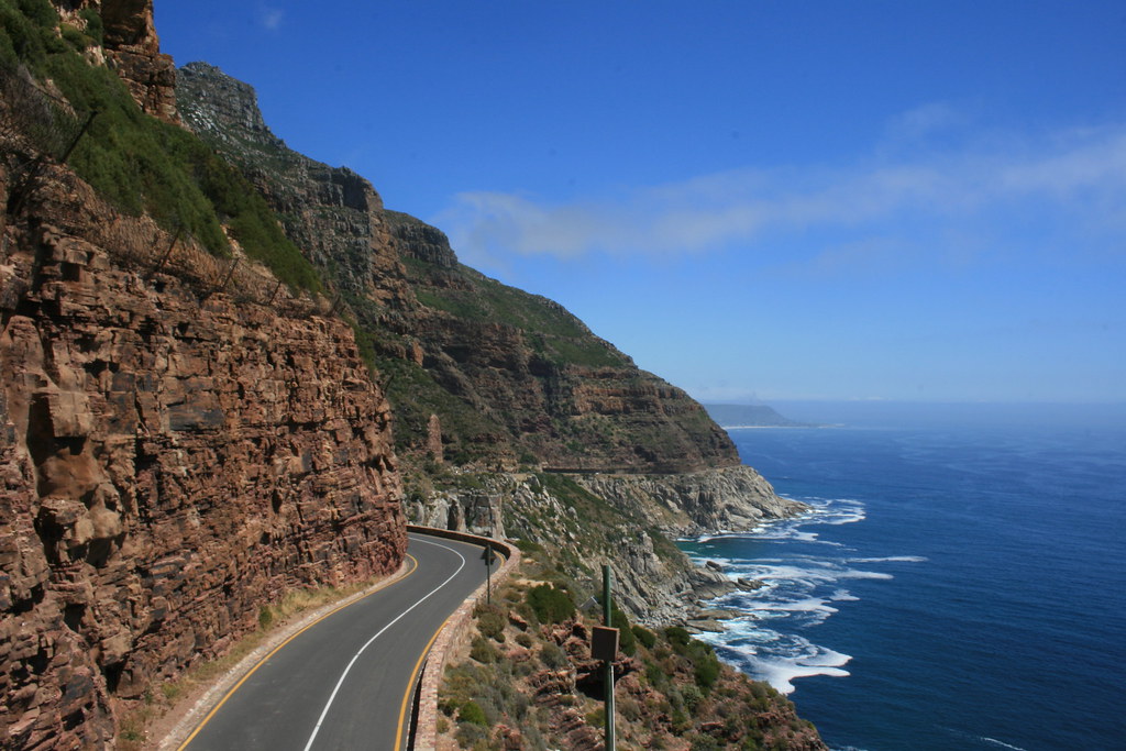
7. Chapman’s Peak Drive, Cape Town, South Africa

Chapman's Peak Drive

Photograph by Ismail Omar


Chapman’s Peak Drive winds it way between Noordhoek and Hout Bay on the Atlantic Coast of the south-western tip of South Africa. The 9km route, with its 114 curves, skirts the rocky coastline of Chapman’s Peak (593m). The drive is affectionately known as “Chappies” and offers stunning 180° views with many areas along the route where you can stop and take in the exquisite scenery. [Source]


8. Stelvio Pass, Eastern Alps, Italy

stelvio pass eastern alps italy 21 Roads to Drive Before you Die

Photograph by Damian Morys Photography


The Stelvio Pass, located in Italy, at 2757 m (9045 feet) is the highest paved mountain pass in the Eastern Alps, and the second highest in the Alps, slightly below the Col de l’Iseran (2770 m, 9088 feet). Stelvio was also picked by the British automotive show Top Gear as its choice for the “greatest driving road in the world”, although their search was concentrated only in Europe. This conclusion was reached after the team went in search of a road that would satisfy every “petrolhead’s” driving fantasies in the premiere of the show’s 10th season. Top Gear later decided that the Transfăgărăşan Highway in Romania was possibly a superior driving road. [Source]


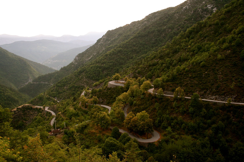
9. Col de Turini, France

Untitled

Photograph by it’s iceberg, baby! on Flickr


The Col de Turini (el. 1607 m) is a high mountain pass in the Alps in the department of Alpes-Maritimes in France. It lies near Sospel, between the communes of Moulinet and La Bollène-Vésubie in the Arrondissement of Nice. It is famous for a stage of the Monte Carlo Rally which is held on the tight road with its many hairpin turns. The Col de Turini has also featured three times in the Tour de France (1948, 1950 and 1975) averaging 7.2% over 15.3 km when approached from the East starting at the valley of the river Vésubie. [Source]


10. Guoliang Tunnel Road, China

guoliang tunnel china 21 Roads to Drive Before you Die

Photograph via Blog-O-Rama


The Guoliang Tunnel is carved along the side of and through a mountain in China. The tunnel is located in the Taihang Mountains which are situated in the Henan Province of China. If you want to get there, you should start your trip in Xinxiang. Leave the city by driving north on Huanyu Avenue (the S229). After 13 miles you’ll enter the town of Huixian. Stay on the S229 for 15 miles more until you reach the junction with the S228. Turn left here and keep following the S229. After 8 miles you reach the village of Nanzhaizen. Turn left again and follow directions to Guoliang, 8 miles further. [Source]


11. Denali Highway, Alaska

Denali Highway

Photograph by Tom Roche


Denali Highway (Alaska Route 8) is a lightly traveled, mostly gravel highway in the U.S. state of Alaska. It leads from Paxson on the Richardson Highway to Cantwell on the Parks Highway. Opened in 1957, it was the first road access to Denali National Park (then known as Mount McKinley National Park). The Denali is 135 miles (217 km) in length. [Source]


12. Karakoram Highway, China/Pakistan

flight to Gilgit 22

Photograph by bjapuri (Ed Sentner)


The Karakoram Highway (KKH) is the highest paved international road in the world. It connects China and Pakistan across the Karakoram mountain range, through the Khunjerab Pass, at an elevation of 4,693 m/15,397 ft. It connects China’s Xinjiang region with Pakistan’s Gilgit–Baltistan and Khyber Pakhtunkhwa regions and also serves as a popular tourist attraction. Due to its high elevation and the difficult conditions in which it was constructed, it is also referred to as the “Eighth Wonder of the World.” The Karakorum Highway is known informally as the KKH, and — within Pakistan — officially as the N-35; within China, officially as China National Highway 314 (G314). [Source]


13. Great Ocean Road, Australia

Great_Ocean_Road_Lorne_Australia

Photograph by DAVID ILIFF, License: CC-BY-SA 3.0


The Great Ocean Road is an Australian National Heritage listed 243-kilometre (151 mi) stretch of road along the south-eastern coast of Australia between the Victorian cities of Torquay and Warrnambool. The road was built by returned soldiers between 1919 and 1932, and is the world’s largest war memorial; dedicated to casualties of World War I. It is an important tourist attraction in the region, which winds through varying terrain alongside the coast, and provides access to several prominent landmarks; including the nationally significant Twelve Apostles limestone stack formations. [Source]


14. Sani Pass, KwaZulu-Natal, South Africa

sani pass kwazulu-natal province south africa

Photograph by Amada44 on Wikimedia Commons


Sani Pass is located in the western end of KwaZulu-Natal province of South Africa on the road between Underberg and Mokhotlong, Lesotho. Sani Pass is a notoriously dangerous road that requires the use of a 4×4 vehicle. The pass is approximately 9 km in length and requires above average driving experience. While South African immigration at the bottom of the pass prohibits vehicles deemed unsuitable for the journey, the Lesotho border agents at the top generally allow vehicles of all types to attempt the descent. Border between the two countries closes at 4:00 pm every day and the Pass is often closed due to weather conditions, especially during winter. [Source]


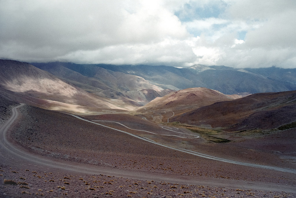
15. Ruta 40, Argentina

Ruta 40

Photograph by m•o•m•o on Flickr


National Route 40 or RN40 (often called Ruta 40), is a route in western Argentina, stretching from Cabo Virgenes in Santa Cruz Province in the south to La Quiaca in Jujuy Province in the north, running parallel to the Andes mountains. The southern part of the route, a largely paved road through sparsely populated territory, has become a well-known adventure tourism journey.
 
Route 40 is the longest route in Argentina and one of the largest in the world (along with the U.S. Route 66 and the Stuart Highway in Australia. It is more than 5,000 km (3,107 mi) long and crosses 20 national parks, 18 major rivers, 27 passes on the Andes, and goes up to 5,000 m (16,404 ft) above sea level in Abra del Acay in Salta. [Source]


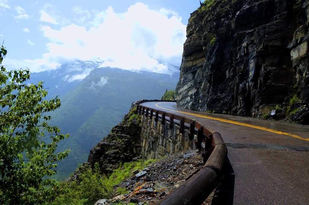
16. Going-to-the-Sun-Road, Glacier National Park, Montana

Going-to-the-Sun Road

Photograph by at38000feet on Flickr


Going-to-the-Sun Road was completed in 1932 and is a spectacular 50 mile, paved two-lane highway that bisects Glacier National Park east and west. It spans the width of the Park, crossing the Continental Divide at 6,646-foot-high Logan Pass. It passes through almost every type of terrain in the park, from large glacial lakes and cedar forests in the lower valleys to windswept alpine tundra atop the pass. Scenic viewpoints and pullouts line the road. In 1983 Going-To-The-Sun Road was included in the National Register of Historic Places and in 1985 was made a National Historic Civil Engineering Landmark. [Source]


17. Dadès Gorges, High Atlas, Morocco

Dades_Gorge_high-Atlas-Morocco

Photograph by Rosino


Carved over the centuries by the Dades River, the Dades Gorge is now a very popular destination for travellers in Morocco. Travellers in 4WD (with a guide) can follow a mountain loop (at certain times of the year), following Dades Gorge as far north as Agoudal, then turning south to head for Todra Gorge. It can be accessed from the small town of Boumaine which lies 116 km northeast of Ouarzazate and 53 km from Tinerhir. A sealed road runs for 63 km through the Gorge as far as Msemrir, after that 4WD is necessary. The best time to visit the lower valleys is from March to May and the mountains are best from May to July. [Source]


18. U.S. Route 550 ‘The Million Dollar Highway, Colorado

million dollar highway us route 550 colorado 21 Roads to Drive Before you Die

Photograph by flamouroux on Flickr


U.S. Route 550 is a spur of U.S. Highway 50 that runs from Bernalillo, New Mexico to Montrose, Colorado in the western United States. The section from Silverton to Ouray is frequently called the Million Dollar Highway. The Million Dollar Highway stretches for about 25 miles (40 km) in western Colorado and follows the route of U.S. 550 between Silverton and Ouray, Colorado. It is part of the San Juan Skyway Scenic Byway. Between Durango and Silverton the Skyway loosely parallels the Durango and Silverton Narrow Gauge Railroad.
 
Though the entire stretch has been called the Million Dollar Highway, it is really the twelve miles (19 km) south of Ouray through the Uncompahgre Gorge to the summit of Red Mountain Pass which gains the highway its name. This stretch through the gorge is challenging and potentially hazardous to drive; it is characterized by steep cliffs, narrow lanes, and a lack of guardrails; the ascent of Red Mountain Pass is marked with a number of hairpin curves used to gain elevation, and again, narrow lanes for traffic—many cut directly into the sides of mountains. [Source]


19. Trollstigen, Rauma, Norway

Trollstigen_Norway

Photograph by Stefan Krause, Germany on Wikimedia Commons


Trollstigen (English: Trolls’ Ladder) is a serpentine mountain road in Rauma, Norway, part of Norwegian National Road 63 connecting Åndalsnes in Rauma and Valldal in Norddal. It is a popular tourist attraction due to its steep incline of 9% and eleven hairpin bends up a steep mountain side. Trollstigen was opened on July 31, 1936, by King Haakon VII after 8 years of construction. During the top tourist season about 2,500 vehicles pass daily.
 
The road is narrow with many sharp bends, and although several bends have been widened during the years 2005 to 2012, vehicles over 12.4 metres long are prohibited from driving the road. At the 700 metres plateau there is a car park and several viewing balconies overlooking the bends and the Stigfossen waterfall. Trollstigen is closed during autumn and winter. A normal opening season stretches from mid-May to October, but may sometimes be shorter or longer due to changes in the weather conditions. [Source]


20. The Amalfi Coast, Italy

amalfi coast italy road to sorrento1 21 Roads to Drive Before you Die

Photograph by Wade 48 on Flickr


The Amalfi Coast is widely considered Italy’s most scenic stretch of coastline, a landscape of towering bluffs, pastel-hued villages terraced into hillsides, corniche roads, luxuriant gardens, and expansive vistas over turquoise waters and green-swathed mountains. Deemed by UNESCO “an outstanding example of a Mediterranean landscape,” the coast was awarded a coveted spot on the World Heritage list in 1997. The Amalfi Coast lies along the southern flanks of the Sorrento Peninsula, a cliff-edged promontory that wanders out from the mainland at the southern end of the Bay of Naples. [Source]


21. Transfăgărășan, Romania

Transfagarasan road romania

Photograph by Horia Varlan


The Transfăgărășan or DN7C is the second-highest paved road in Romania. Built as a strategic military route, the 90 km of twists and turns run north to south across the tallest sections of the Southern Carpathians, between the highest peak in the country, Moldoveanu, and the second highest, Negoiu. The road connects the historic regions of Transylvania and Wallachia, and the cities of Sibiu and Pitești.
 
The road climbs to 2,034 metres altitude. The most spectacular route is from the North. It is a winding road, dotted with steep hairpin turns, long S-curves, and sharp descents. Top Gear host, Jeremy Clarkson, had said about Transfăgărășan that, “this is the best road… in the world” – a title the program’s presenters had previously given to the Stelvio Pass in Italy. [Source]


If you enjoyed this post, the Sifter
highly recommends:


Seeing the World Through an Airplane Window [50 pics]


7989803932 eeabb7292c c 21 Roads to Drive Before you Die


Girlfriend Leads Photographer Around the World


photographer follows girlfriend around the world holding hand photo series 15 21 Roads to Drive Before you Die


25 Mind-Blowing Aerial Photographs Around the World


rano kau volcano in rapa nui national park easter island chile 21 Roads to Drive Before you Die


05 Mar 23:37

Disco Lights Recalled by Tween Brands Due to Electrical Shock Hazard; Sold Exclusively at Justice

The electrical wiring in the "Style my Room by Justice" lamp base is accessible and the lamp can overheat.
05 Mar 23:35

Floor Sitting: Do You Spend Enough Time on the Ground?

by Mark Sisson

sitting on the floorA while back, I developed an interest in the “archetypal postures” of ground-based sitting, squatting, and kneeling. My interest persisted, and I thought a full-on post about the potential benefits and logistics of floor sitting would be fun and helpful.

I’ve found that there aren’t very many studies examining the effects of floor sitting, kneeling, and squatting on health, posture, or pain. You’ve got the “stability ball literature” (long story short: sitting on a stability ball tends to “increase the level of discomfort”), 69but sitting on an inflated unstable sphere is more physiologically novel than a regular chair. I’m not sure there’s much benefit and it looks pretty silly. There’s also a brief study70 that showed sitting in a backless chair improved levels of consciousness in patients with prolonged consciousness disturbance. For the most part, though, it’s a pretty barren landscape of research.

I think that’s okay. I’m not entirely convinced we always need research to confirm what we already (should) implicitly know.

As Babies, We Start on the Floor

Sometimes hard data isn’t really needed, especially when you consider two unassailable facts about our relationship with the floor. First, individually, we all start out on the floor. As babies, we lie there, essentially kicking things off as eating, pooping sacks of wiggling, basically immobile flesh. Then, we graduate to flipping over onto our stomachs, lolling our heads around (once we develop sufficient neck strength), crawling toward vacant electrical sockets, hesitantly standing, and finally walking. It’s on the floor that we learn to move. We may not be doing terribly complex or impressive stuff down there, but that first year or two is incredibly formative for the rest of our movement lives. We’re building a foundation made primarily of contralateral crawling and “tummy time.” Graduating beyond the floor to full on bipedalism doesn’t mean we should totally ignore where we came from.

Chairs are a Recent Invention

Second, chairs only recently became part of our lives. Folks as early as the ancient Egyptians had them, but they were a luxury item reserved for the upper classes. Your average Neolithic human sat on chests or benches until chairs became a mass-produced staple that everyone could afford. Earlier than that, for most of human history, formal-sitting furniture simply didn’t exist. Paleolithic posteriors surely rested upon rocks and logs and stumps when the opportunity arose, but those aren’t the same as having permanent fixtures that allow you to take a load off whenever you want. Human bodies were not designed with chairs in mind. We did do a lot of lounging around – I’m not arguing we never stopped moving or anything – but we did so on the ground, rather than on a bunch of folding chairs.

Sitting down in a chair does funny things to our bodies. It stretches out our glutes, making them inactive, loose, and weak. People by and large no longer know how to activate their butt muscles due to excessive amounts of chair sitting. Sitting in a chair also keeps the hip flexors in a short, tight, contracted position for extended amounts of time, which can inhibit full hip extension and lead to that hunched over position you often see older folks shuffling around with. And that’s not even mentioning the extensive (and growing) literature showing how sitting for too long increases mortality and degenerative disease, which I’ve covered in plenty of posts and Weekend Link Loves. This post isn’t really about that, anyway.

What might be most important, though, is what sitting in a chair doesn’t do. It doesn’t allow us to rest in the full squat position, an ability we’re born with but quickly forget how to do. It doesn’t let us do much of anything. Sitting becomes a totally passive act, where we’re slumped over, shoulders rounded, feet twisted up and resting on the chair legs, totally dependent on the structure of the chair to support our weight – rather than using our musculature and arranging our skeletal system in such a way that we support ourselves. Doesn’t it seem inconceivable that an animal – any animal – would evolve to require furniture in order to rest comfortably without incurring a disability?

That’s partly why it makes some sense to hang out on the floor more.

6 Floor Sitting Positions to Better Align Your Body

We need the “stress” of supporting our own body weight and making sure our structures are in alignment. Here are a few positions to try out:

  • Squat
  • Seiza
  • Half kneel
  • Crossed legs
  • Crossed legs variation
  • Make up your own

Resting Squat
sitting on the floor squat

Squats are the default resting position of humans. Kids can do this easily, but once they start going to school and sitting in a chair for six hours a day, they lose it. The goal here is to get your heels on the ground. Resting on the balls of your feet is easier, but it’s harder on your knees and thighs. The heels-down squat, which requires more flexibility but distributes the pressure across your hips, is far more sustainable.


Seiza

sitting on the floor seiza

Seiza is the formal way to sit in Japan, resting on the lower legs, butt on heels. Placing a small pillow or rolled up towel under your knees can make the transition easier, especially if you have a bad knee or two.


Half Kneel

floor sitting half kneel


Like seiza, except one of your feet is on the ground, heel down, in front of you in a squat position. Like these guys.


Crossed Legs

sitting on the floor cross leggedFor many people, this is the most comfortable, natural way to sit on the floor. You can place your feet flat against each other, cross at the ankles, or place your calves against each other. You can even go full lotus.


Crossed Leg Variation


This is one my favorite ways to sit. From the basic crossed leg position, place one hand flat on the floor and lean on it. Bring the opposite leg up and place the foot flat on the floor. Your opposite leg will be in a squat position. Switch hands and legs if it gets uncomfortable.


Make Up Your Own

Human limbs are funny, bendy things. We can contort ourselves into lots of positions, and as long as you’re on the floor, supporting your own weight and feel comfortable doing it, it’s difficult to hurt yourself. Our bodies are good at giving feedback before things go really wrong. If your arm starts to go numb or your toes get tingly, switch it up! Try coming up with some of your own variations for sitting on the ground and report back.

Floor Activities for Improved Body Alignment

  • CrawlContralateral crawling is one of the most fundamental ways to move. It’s a strong developer of shoulder and hip mobility and strength, and it’s simply a fun way to see and experience the world.
  • Watch TV on the floor. There’s nothing inherently wrong with TV. Sure, it can be taken to the extreme and crowd out active living, but it’s arguably a golden age of television as far as quality goes. The couch sitting, though, is what gets you.
  • Eat dinner on the floor. This isn’t something I created out of thin air; plenty of cultures eat dinner on the ground.
  • Try different positions. You’ll probably find that floor living is a constantly shifting existence, where instead of remaining in the same position for hours at a time, you’re moving around all the time without even trying. You’re switching from the right arm to the left arm to the right elbow to the full lotus position to the half kneel to the full kneel to the full squat just in the first two hours.
  • Practice moving between positions. Go from standing to a half kneel to a kneel to a seiza to a kneel to a half kneel to standing.
  • Practice standing up. We can’t live on the floor all the time. Sometimes, we need to stand up and get on with our lives. A smooth transition between floor living and standing is key to health and mobility. For an example transition, check out one of my buddy Erwan’s (of MovNat) methods.

Spend at least an hour a day sitting on the ground and another fifteen minutes practicing different ways to move between positions and another fifteen practicing how to stand up and sit back down. Shoot for ten minutes of crawling, too. You can do most of these things while doing other things, like watching TV or reading or talking, so it’s not like you’re wasting time. My guess is that you’ll take to this like a fish to water.

Why is this so important?

The way we sit, and where we do it, changes the function of our bodies. It even alters the length of musculature.71 In countries where squatting and other forms of floor living are seamlessly weaved into everyday life, people still retain the mobility to do all that stuff into old age. I’ve got a buddy from Thailand who moved over to Hollywood as a teenager in the late sixties and still retains the ability to sit in a full squat, painlessly and effortlessly. This guy is an avid user of chairs and everything Western. He’s not a gymgoer at all, and he’s never even heard of a foam roller or Mobility WOD, but because he got the right floor living experience during the formative years, he can still squat and move around on the floor. Unfortunately, for many of us in Western countries who stopped floor living right around age four or five, we may never quite get there – but we can certainly do a lot better than we are now.

Now that you have some idea of what to do when you’re on the ground, I’d like you to spend the next week doing as much floor living as possible. I don’t expect you to ditch the office chair and roll around the ground while at work, but I do expect you to get in some quality floor time when you’re at home.

Let’s hear from you guys. How do you handle yourselves on the floor? What’s your favorite go-to position?

Classic-golden-hawaiian-mango-jalapeno-bbq-sauces

References

  1. https://www.mic.com/p/quarantine-doesnt-suck-for-everyone-apparently-22827568,
  2. https://www.psychologytoday.com/us/blog/traversing-the-inner-terrain/201102/the-victim-identity
  3. https://www.entrepreneur.com/article/284791
  4. http://charm.cs.uiuc.edu/users/jyelon/lowcarb.med/topic9.html
  5. https://www.ncbi.nlm.nih.gov/pubmed/20093739
  6. https://onlinelibrary.wiley.com/doi/full/10.1111/acel.12953
  7. https://www.ncbi.nlm.nih.gov/pubmed/25948672
  8. https://www.ncbi.nlm.nih.gov/pubmed/26467133
  9. https://www.ncbi.nlm.nih.gov/pubmed/31697702
  10. https://www.ncbi.nlm.nih.gov/pubmed/29094215
  11. https://www.ncbi.nlm.nih.gov/pubmed/31557143
  12. https://www.ncbi.nlm.nih.gov/pubmed/31364705
  13. https://www.ncbi.nlm.nih.gov/pubmed/21414089
  14. https://www.ncbi.nlm.nih.gov/pubmed/22293292
  15. https://www.ncbi.nlm.nih.gov/pubmed/22529837
  16. https://www.ncbi.nlm.nih.gov/pubmed/24401291
  17. https://www.ncbi.nlm.nih.gov/pmc/articles/PMC3426261/
  18. https://www.ncbi.nlm.nih.gov/pmc/articles/PMC4685482/
  19. https://www.ncbi.nlm.nih.gov/pmc/articles/PMC3019310/
  20. http://www.tandfonline.com/doi/abs/10.1185/030079908X291967
  21. https://www.ncbi.nlm.nih.gov/pubmed/29701488
  22. https://www.ncbi.nlm.nih.gov/pubmed/26353786
  23. https://www.ncbi.nlm.nih.gov/pubmed/27852613
  24. https://www.ncbi.nlm.nih.gov/pubmed/16557055
  25. https://www.medscape.com/viewarticle/586468_3
  26. https://www.sciencedirect.com/science/article/pii/S155041311830130X
  27. https://pubmed.ncbi.nlm.nih.gov/21677272/
  28. https://pubmed.ncbi.nlm.nih.gov/16280423/
  29. https://www.sciencedirect.com/science/article/pii/S155041311830130X
  30. https://pubmed.ncbi.nlm.nih.gov/16439708/
  31. https://pubmed.ncbi.nlm.nih.gov/17197279/
  32. https://pubmed.ncbi.nlm.nih.gov/12396160/
  33. https://pubmed.ncbi.nlm.nih.gov/21178922/
  34. https://pubmed.ncbi.nlm.nih.gov/1454084/
  35. https://www.ncbi.nlm.nih.gov/pmc/articles/PMC5491979/
  36. https://www.accessdata.fda.gov/scripts/cdrh/cfdocs/cfcfr/cfrsearch.cfm?fr=101.9
  37. https://pubmed.ncbi.nlm.nih.gov/20102837/
  38. https://www.ncbi.nlm.nih.gov/pmc/articles/PMC4363942/
  39. https://academic.oup.com/jcem/article/82/11/3647/2865985
  40. https://www.ncbi.nlm.nih.gov/pmc/articles/PMC3174765/
  41. https://www.ncbi.nlm.nih.gov/pmc/articles/PMC3296868/
  42. https://www.ncbi.nlm.nih.gov/pmc/articles/PMC4454393/
  43. https://academic.oup.com/jcem/article/91/8/3232/2656790
  44. https://pubmed.ncbi.nlm.nih.gov/20368473/
  45. https://www.ncbi.nlm.nih.gov/pmc/articles/PMC5813183/
  46. https://cronometer.com/
  47. https://pubmed.ncbi.nlm.nih.gov/18589032/
  48. https://pubmed.ncbi.nlm.nih.gov/22691622/
  49. https://pubmed.ncbi.nlm.nih.gov/23446962/
  50. https://www.ncbi.nlm.nih.gov/pmc/articles/PMC4989512/
  51. https://pubmed.ncbi.nlm.nih.gov/6694559/
  52. https://pubmed.ncbi.nlm.nih.gov/11010936/
  53. https://pubmed.ncbi.nlm.nih.gov/22535969/
  54. https://journals.ke-i.org/index.php/mra/article/view/908
  55. https://pubmed.ncbi.nlm.nih.gov/15466943/
  56. https://pubmed.ncbi.nlm.nih.gov/11838888/
  57. http://www.cell.com/ajhg/abstract/S0002-9297(14)00422-4
  58. https://www.cdc.gov/diabetes/prevent-type-2/type-2-kids.html
  59. https://www.cambridge.org/core/journals/public-health-nutrition/article/involvement-in-home-meal-preparation-is-associated-with-food-preference-and-selfefficacy-among-canadian-children/C4347E7475C945893A82B19E5F93CC90
  60. https://www.sciencedirect.com/science/article/abs/pii/S0195666301904829
  61. https://eetonderzoek.nl/wp-content/uploads/publikaties/havermans_en_jansen_appetite2007.pdf
  62. https://www.ncbi.nlm.nih.gov/pubmed/14702019
  63. https://www.sciencedirect.com/science/article/abs/pii/S0272638606015137
  64. https://www.ncbi.nlm.nih.gov/pubmed/10757623
  65. https://www.ncbi.nlm.nih.gov/pmc/articles/PMC4159735/
  66. https://www.ncbi.nlm.nih.gov/pmc/articles/PMC4446506/
  67. https://www.ncbi.nlm.nih.gov/pmc/articles/PMC5544304/
  68. https://www.ncbi.nlm.nih.gov/pubmed/31468384
  69. http://www.ncbi.nlm.nih.gov/pubmed/16696264
  70. http://www.ncbi.nlm.nih.gov/pubmed/21796026
  71. http://www.pnas.org/content/110/4/1237.abstract

The post Floor Sitting: Do You Spend Enough Time on the Ground? appeared first on Mark's Daily Apple.

05 Mar 23:35

TSA to allow small knives, bats, clubs on planes

Air Travelers KnivesAirline passengers will be able to carry small knives, souvenir baseball bats, golf clubs and other sports equipment onto planes beginning next month under a policy change announced Tuesday by the head of the Transportation Security Administration.
05 Mar 18:33

How One Band Turned A Ghost Town Into A Giant Recording Studio

How One Band Turned A Ghost Town Into A Giant Recording Studio

by Jacob Ganz

March 4, 2013

Listen Now

Morning Edition

7 min 21 sec  
  • The members of Efterklang in Piramida: Mads Brauer (left), Rasmus Stolberg (center) and Casper Clausen.Hide caption The members of Efterklang in Piramida: Mads Brauer (left), Rasmus Stolberg (center) and Casper Clausen. Previous Next Courtesy of Efterklang
  • Piramida, shot from above. The ghost town, once an active Russian mining settlement, is on the island of Spitsbergen, in the archipelago of Svalbard, which is controlled by Norway.Hide caption Piramida, shot from above. The ghost town, once an active Russian mining settlement, is on the island of Spitsbergen, in the archipelago of Svalbard, which is controlled by Norway. Previous Next Courtesy of Efterklang
  • Efterklang's Mads Brauer records Hide caption Efterklang's Mads Brauer records "the world's northernmost grand piano," one of the reasons the band wanted to visit Piramida. Previous Next Courtesy of Efterklang
  • Empty buildings and rusty swing sets in the town of Piramida. The Russian mining colony that built and populated the settlement abandoned it in 1998.Hide caption Empty buildings and rusty swing sets in the town of Piramida. The Russian mining colony that built and populated the settlement abandoned it in 1998. Previous Next Courtesy of Efterklang
  • A broken drum, one of the artifacts left behind by Piramida's residents that was actually intended to be a musical instrument.Hide caption A broken drum, one of the artifacts left behind by Piramida's residents that was actually intended to be a musical instrument. Previous Next Courtesy of Efterklang
  • Efterklang's singer, Casper Clausen, records the sound of his footsteps on a long boardwalk running out of town. The sound can be heard in the opening of the song Hide caption Efterklang's singer, Casper Clausen, records the sound of his footsteps on a long boardwalk running out of town. The sound can be heard in the opening of the song "Dreams Today." Previous Next Courtesy of Efterklang
  • Hide caption "It almost sounds like a vibraphone." Mads Brauer (left) and Rasmus Stolberg record sounds atop one of the empty fuel tanks that Brauer would manipulate into the organlike sounds on the song "Sedna." Previous Next Courtesy of Efterklang
  • The mountain that looms above Piramida and which gave the town — as well as Efterklang's fourth album — its name.Hide caption The mountain that looms above Piramida and which gave the town — as well as Efterklang's fourth album — its name. Previous Next Courtesy of Efterklang
  • Part of the abandoned mining apparatus in the town of Piramida.Hide caption Part of the abandoned mining apparatus in the town of Piramida. Previous Next Courtesy of Efterklang
  • The spike-covered fuel tank that the band taught itself to play. A recording of the tank opens Piramida's first song, Hide caption The spike-covered fuel tank that the band taught itself to play. A recording of the tank opens Piramida's first song, "Hollow Mountain." Previous Next Courtesy of Efterklang
  • An arctic-inspired mosaic on one of the walls of an abandoned building in Piramida.Hide caption An arctic-inspired mosaic on one of the walls of an abandoned building in Piramida. Previous Next Courtesy of Efterklang
  • Now drained, the swimming pool in Piramida was once warmed by residual heat from generating electricity. Hide caption Now drained, the swimming pool in Piramida was once warmed by residual heat from generating electricity. "It was fantastic," says Hein Bjerck, a former Spitsbergen resident. Previous Next Courtesy of Efterklang
  • The abandoned gymnasium.Hide caption The abandoned gymnasium. Previous Next Courtesy of Efterklang

1 of 13

View slideshow i

In August of 2011, the three members of the Danish band Efterklang, dressed in survival suits, loaded a small recording studio worth of equipment onto an open boat docked on the island of Spitsbergen. Soaked by rain and rough seas, the boat pushed off into the fjord that separates the town of Longyearbyen from their destination: Piramida, a former Russian coal mining settlement abandoned by the state-held company that ran it in 1998.

In front of them: nine days in the cold, no human contact outside their small party and the threat of polar bear attacks.

"It was the longest boat ride I'd ever taken," says Rasmus Stolberg, Efterklang's bassist. "It felt like a very surreal and extreme way to begin making an album."

Spitsbergen is the largest island in Svalbard, an arctic archipelago about the size of Sri Lanka, 400 miles north of Norway's farthest northern tip. "It's a territory controlled by Norway, but it's not really Norway," Stolberg says.

Mads Brauer, who plays electronics for the band, says that starting from scratch on each new album is just part of Efterklang's process. Piramida promised the cleanest slate imaginable. There were no people in the town, just crumbling evidence of former occupants and their lives. The plan was to take recording equipment — mallets to bang on whatever they could find, microphones and flash recorders to document the noises they made — and return home with raw sound they could twist and turn into a new album.

A Ghost Town As A Studio

The thousands of miles between their adopted home of Berlin and an abandoned mining town halfway between the Arctic Circle and the North Pole might seem like a drastic length to travel, but the band members were inspired. For musicians obsessed with sound, Piramida offered unimaginable opportunities: to turn every object within sight into a musical instrument; to turn an entire town, in effect, into a recording studio.

"This place was quite optimal because we could kind of record a city without people in it," says lead singer Casper Clausen. "You can go to any other city and try and record, but there would always be some kind of sounds you're not in control of in the background."

Getting there wasn't easy. Access to Piramida is still controlled by the mining company that packed up and left in 1998, and despite emails, faxes and "a friend in Moscow that went and knocked on the door," they heard no reply. Finally, a German documentary crew who had permission to travel offered them a ride.

"Sitting in a boat like that with all of our equipment, going to this ghost town, not having written one song yet, everything felt so new and fresh and without direction," Clausen says. "In that sense it was a scary trip in many ways, I think."

After docking in Piramida, there was nothing to do but wander, collect sounds and worry about the polar bears, one of three land mammals native to the island. One of the reasons for taking the trip, Stolberg says, was hearing that the world's northernmost grand piano sits in the town's empty concert hall. But most of the instruments the band found weren't designed with music in mind. The trio began exploring the abandoned warehouses, playgrounds, residences and courtyards, banging on corrugated metal siding, lamps and fuel tanks. ("When you're up there for nine days, you get to hit on a lot of metal," Stolberg says. "After some days, all these start to sound the same to you.")

Some objects they found had an innate musicality. Clausen recorded his footsteps while running on a long boardwalk, which would later become the beat for one of the songs on the album. He crawled into pipes and sang, his clear tenor multiplying into a ghostly choir as it bounced off metal walls. A fuel tank, half full of water and covered in spikes — to hold insulation that had long since rotted away — turned into a giant percussive instrument once the band discovered that each spike had a distinct tone. Once they taught themselves to play it, it sounded a little like a kalimba.

YouTube

New Sounds Out Of Old

Most of the sound Efterklang recorded in Piramida had to be treated in some way once the musicians returned home to Berlin — taken apart and reassembled. Fortunately, that kind of thing is built into the band's process. (As well as its name: in Danish, "efterklang" means "after-sound," or reverberation. Talk to Stolberg about the trip, and he can't help but giddily bring up this bit of trivia.)

Reverberation also turns out to be crucial to the way Mads Brauer makes new sounds out of old ones. The finished songs on Efterklang's album, which the band named Piramida, have an epic, widescreen character, and it was Brauer's job to transform the dinky sounds of mallets hitting rusty metal into something that could communicate the scale of the place where they were recorded.

YouTube

For "Sedna," a hymnlike song on the album, Brauer started with a recording he made after climbing atop an enormous, empty fuel tank: "There's this valve, and if you hit it with a mallet it almost sounds like a vibraphone." Brauer also lowered a microphone on a cable down through the valve, to capture the sound of the reverberation from inside the tank.

While the vibraphonelike noise from tapping on the valve disappeared in a couple of seconds, the sound inside the tank took much longer to decay. By cutting and looping a tiny portion of that decay, Brauer was able to make a sustained note with "a little movement in the sound." He then layered that sound with the decay from a note played on a piano. The combination sounded something like an organ. He programmed a keyboard to shift the pitch so it could actually be played like one, and picked out a melody around which the band composed and recorded the song.

An Abstraction

The finished songs bring up a question: When you listen to the album, sounds like the manufactured "organ" on "Sedna" can fade into the dense fabric of the music. Some recordings made it onto the final album nearly untouched, such as the spiky fuel tank played on Piramida's opening track, "Hollow Mountain." But often, you don't hear the abandoned town at all. So why was it so important to make the journey there?

Stolberg calls the album "an abstraction." Brauer agrees. "[Piramida is] not a documentation of the place. It's just where we started. And the whole inspiration point of it is, in a way, just as important as the sound that we recorded."

Hein Bjerck has felt that same rush of inspiration. Now an anthropology professor at the Norwegian University of Science and Technology in Trondheim, Bjerck worked in the governor's office in Longyearbyen for three years in the late 1990s. When he first visited Piramida almost 20 years ago, it was still an active mining town with close to 500 inhabitants.

The Russians who worked and lived there served two-year contracts and rarely got to leave, but they had a good life, Bjerck says. They had a metropolitan mindset and dressed in furs rather than Gore-Tex. The town used residual heat from producing electricity to warm the buildings, which included a greenhouse, the concert hall with that grand piano and sports facilities.

"I remember I was there in the last years before the town was abandoned. I think I was one of the last ones that was actually swimming in the heated pool," Bjerck says. "It was fantastic."

More than a decade after the mining company packed up and left, Bjerck returned to write a book about the town called Persistent Memories: Pyramiden — A Soviet Mining Town in the High Arctic, published in 2010 ("Pyramiden" is the Norwegian name for the town). He says he could see the remnants of a life of longing still hanging on the walls of the empty homes.

"There are many pictures of things that were lacking up there. Dogs and cats and rivers and nice woods and of course all their family that they're missing," he says. "Also, typically, an abundance of maps and pictures of airplanes that are kind of pointing from the town and back, and also calendars where you can see they were counting down the days in these two-year-long periods."

The members of Efterklang stepped into this place with only one thing worked out: They were starting, together, from zero. They had no songs, no structure, no album.

"We had a trip together, the three of us," Clausen says. "We started this off with an adventure to kind of formulate a starting point. And we found a lot of sounds, but we also sharpened our senses. I think that was the most important [thing] about it."

Sharpened senses to locate and carefully preserve the echoes of a slowly decaying city. Raw sounds became finished songs. Now out on tour, the band has come up with a third step in Piramida's progress: Live instrumentation and orchestral flourishes in new versions of the songs pull them further from the raw audio. Like the town it was named for, the album is an artifact of a place and a moment, once creative and thriving, now frozen in time.

YouTube Copyright 2013 NPR. To see more, visit http://www.npr.org/. Copyright 2013 NPR. To see more, visit http://www.npr.org/.
04 Mar 11:58

c. 1965 : Barack Obama and his grandfather

by Chris Wild
03 Mar 20:02

Socialmatic Camera Creates Real-Life Instagram Pics

by Eric Larson

A new company called Socialmatic announced a branding deal with Polaroid to create a Instagram-esque camera that instantly prints photos.

More About: instagram, Newsy, photo gallery, Video

03 Mar 01:42

National Archives: Searching for the Seventies

“Searching for the Seventies” takes a new look at the 1970s using remarkable color photographs taken for a Federal photography project called Project DOCUMERICA (1971-1977). Created by the Environmental Protection Agency (EPA), DOCUMERICA was born out of the decade’s environmental awakening, producing striking photographs of many of that era’s environmental problems and achievements. Drawing its inspiration from the depression era Farm Security Administration photography project, project photographers created a portrait of America in the early-and-mid-1970s. They documented small Midwestern towns, barrios in the Southwest, and coal mining communities in Appalachia. Their assignments were as varied as African American life in Chicago, urban renewal in Kansas City, commuters in Washington, DC, and migrant farm workers in Colorado. The exhibit, featuring 90 images from the project opens March 8, 2013 at the National Archives in Washington D.C. It runs through September 8, 2013. What follows is a small sampling of the collection digitized by the National Archives. -- Paula Nelson (NOTE: Captions were provided.)( 30 photos total)
Children play in the yard of Ruston home, while a Tacoma smelter stack showers the area with arsenic and lead residue. Ruston, Washington, August 1972. (Gene Daniels/National Archives/Records of the Environmental Protection Agency)


03 Mar 00:09

Triangle tech fair coming this spring

by Lauren K. Ohnesorge
Looking for talent? North Carolina Technology Association, Inc., CED and Work in the Triangle are teaming up for a “Come Tech Out the Triangle Job Fair” in April. The aim is to promote job openings in the tech industry. The fair, set to take place in conjunction with NCTA’s State of Technology conference, is expected to attract more than 300 job-seekers, but employer participation is limited to the first 30 companies to sign up. Already, Durham’s Bronto Software, Morrisville’s ChannelAdviser…
03 Mar 00:09

Durham bike-car hybrids to debut in Germany

by Lauren K. Ohnesorge
Durham-based Organic Transit is taking its bike-car hybrid overseas. The ELF car will be presented at the CeBIT 2013 trade show in Hanover, Germany March 5-9 as one of 50 startup competition finalists. You’ll recall the enclosed solar/pedal tricycles have a base price of $4,000 and achieve an equivalent of 1,800 miles per gallon without burning any fuel. OT is collaborating with another Triangle company, Sky Highways, Inc., out of Chapel Hill. The company has developed an Organic Transit Dashboard…
02 Mar 22:37

Evernote Resets All User Passwords After Security Breach

by Camille Bautista

Evernote implemented a service-wide password reset Saturday after the company discovered suspicious activity on its network.

The note-taking service issued a statement on its site, saying that no stored user content or financial data was changed or lost, but that hackers gained personal information including usernames, passwords and email addresses.

Though they were accessed, passwords stolen in the breach are protected by one-way encryption. The encryption makes it more difficult for hackers to crack the content, but Evernote users are still vulnerable.

Users will be prompted to change their passwords the next time they log in, and the change affects all other Evernote apps. Th…
Continue reading...

More About: evernote, hack, hackers, security, Tech

01 Mar 00:27

Barry Manilow donates piano to Wake County Schools

by Jesse Burkhart
Calling all Fanilows whose musical instruments are collecting dust in a corner somewhere. Wake County Schools is holding an instrument drive in which those who donate new or lightly used instruments will receive two free tickets to Barry Manilow's concert at PNC Arena on April 26. Who made the first donation? Why, Manilow himself.