Cowboy Who?
Shared posts
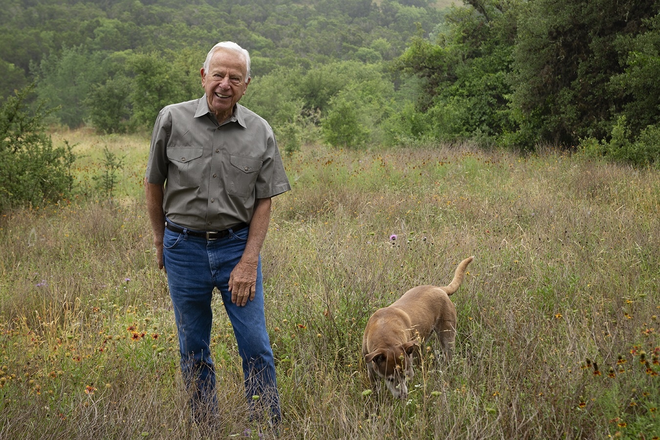
Remembering J. David Bamberger: The Church’s Chicken tycoon-turned land conservationist
Protest breaks out at Dilley immigration detention facility holding 5-year-old Liam Ramos
some ways to help right now
I don’t know what to say about what’s happening that won’t sound performative, but business as usual doesn’t feel okay right now. It’s not okay.
I’m honestly not sure how to meet this moment with a blog about work. But I’m here, and I’m horrified. If you are, too, here are some ways you can help.
Contact your elected representatives. Here’s one script. Here’s another. Here’s a letter you can send.
A hub of organizations, fundraisers, mutual aid needs, and more: Stand With Minnesota
American Civil Liberties Union
Community rapid response and ICE observation trainings: Unidos MN
(Comments are closed on this one.)
The post some ways to help right now appeared first on Ask a Manager.
SPARC and Curationist Join Widening Effort to Protect Our Future Memory

Two more organizations—SPARC and Curationist—have decided to sign the Statement on Four Digital Rights for Memory Institutions Online, demonstrating its broad appeal to memory institutions of different stripes.
SPARC and Curationist represent key collaborative institutions from library world and the museum space, respectively. SPARC is an umbrella advocacy group with more than 250 North American research libraries and academic organizations as its members; Curationist, a digital platform helping museums and archives open their collections to each other and to the world.
Notwithstanding their distinct areas of focus, SPARC and Curationist are dedicated memory institutions, specializing to meet the needs of their patrons, members, and users, but never forgetting their shared goal of preserving culture and providing equal access to knowledge. That is why both are concerned about the effect that outdated laws are having on cultural heritage organizations in the digital age—and why they’ve joined Our Future Memory’s fight to protect memory institutions’ absolutely vital operations, in a media environment where affordable access to trustworthy information is at a premium.
“Curationist is signing this statement because the future of cultural memory depends on the ability of museums, libraries, and archives to operate fully and responsibly in the digital world,” said Executive Director Christian Dawson. “These rights are not abstract ideals. They are the practical foundations that allow institutions to preserve knowledge, provide access, and collaborate across borders. Our work exists to help make these rights real in practice, and we are proud to stand with a global community committed to protecting the past to power the future.”
To be sure, these “practical foundations” should not be controversial. They reflect the historical operations that have made libraries, archives, museums, and other memory institutions such an essential part of our information ecosystem. The Statement calls for legal assurances of memory institutions’ right and ability to:
- Collect digital materials
- Preserve digital collections
- Provide controlled digital access
- Cooperate across institutions
Thanks to SPARC and Curationist, the coalition to protect our future memory just got a bit bigger.
Ready to Join?
Your organization can join the movement and sign the Statement by going to the Our Future Memory website.
Want to learn more?
Register and join our informational webinar this Tuesday, January 27: “Protect Our Future Memory: Join the Call for Library Digital Rights.”
Recordings From Our Public Domain Day Celebrations are Now Available
This week, Internet Archive celebrated Public Domain Day with a lively mix of ideas, art, and community. Session recordings are now available to revisit or discover the highlights.

In our daytime virtual session, we invited audiences to step into The Case of the Disappearing Copyright, a playful, thought-provoking celebration of the works newly freed into the public domain. Watch the recording.

Our in-person party turned Public Domain Day into a lively celebration of art, film, and the public domain. Artist in residence Cindy Rehm shared The Seers, her public-domain–inspired work, followed by a screening of the winning films and honorable mentions from the Public Domain Film Remix Contest. Watch the livestream.
Last week I caught him kneeling in front of a picture of Leonard Nimoy. He was burning incense and…

Last week I caught him kneeling in front of a picture of Leonard Nimoy. He was burning incense and singing snatches of The Ballad of Bilbo Baggins.
He’s been in space too long.

ROUND THINGS. Today we are promoting ROUND THINGS. Today only, half off all ROUND THINGS.

ROUND THINGS. Today we are promoting ROUND THINGS. Today only, half off all ROUND THINGS.
I thought it would be really neat if a person could merely think of a sound and it could be played…

I thought it would be really neat if a person could merely think of a sound and it could be played by this mind-control guitar.
My MUBI password

This page took a bit of wrangling. A group of four characters who move as one are a bit of a chore. A lot of little details to keep in line. Anyway, what’s going on with Glenn and Claire?
The post My MUBI password appeared first on Bad Machinery.
Rams-Seahawks Game Preempted By ‘Everybody Hates Chris’ Rerun
The post Rams-Seahawks Game Preempted By ‘Everybody Hates Chris’ Rerun appeared first on The Onion.
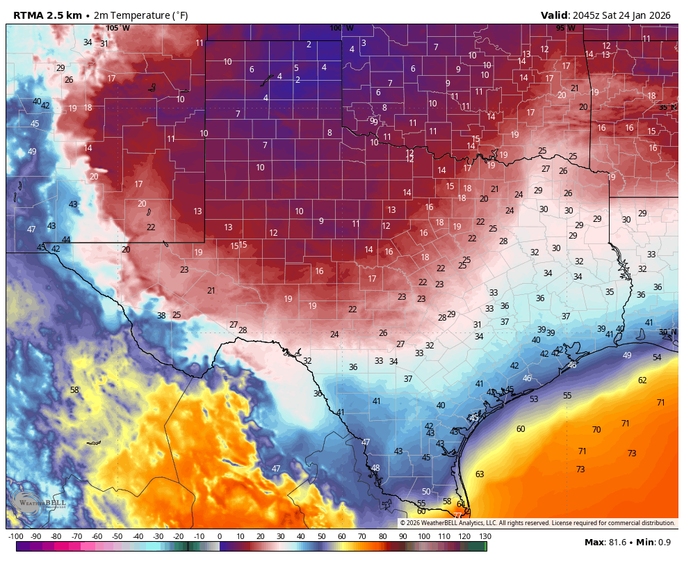
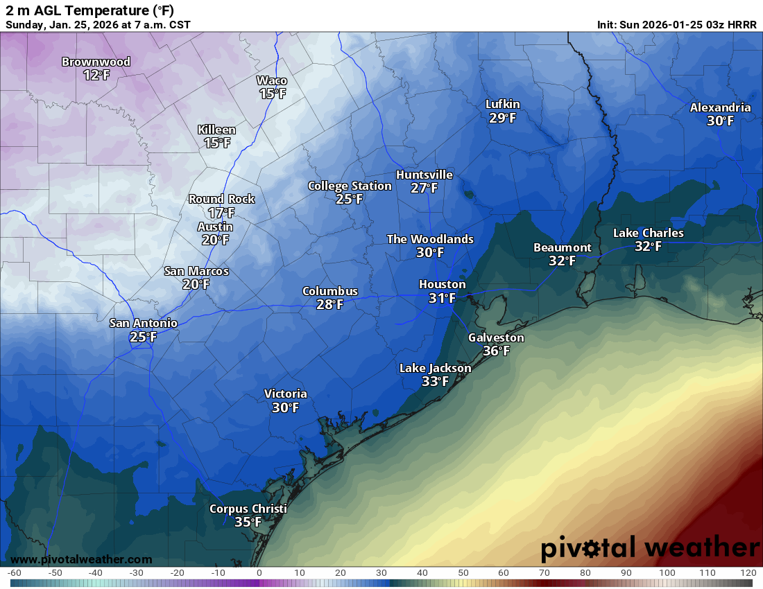
Houston dodges a bullet with ice storm, but two very cold nights remain
In brief: So the great ice-apocalypse forecast by some did not happen in Houston. We explain why not, and why most Houston roads are good to go. Also, we take a peek at lows tonight and Monday night.
So what happened?
If you’ve been carefully reading Space City Weather for the past week—and you have, haven’t you?—we’ve talked ad nauseum about the uncertainty surrounding air temperatures on Sunday morning, and what that would mean for freezing rain and ice accumulations. Back on Thursday, for example, I outlined a couple of scenarios that were possible; a faster freeze and a slower freeze. In the end we got lucky, and the “slower freeze” happened.
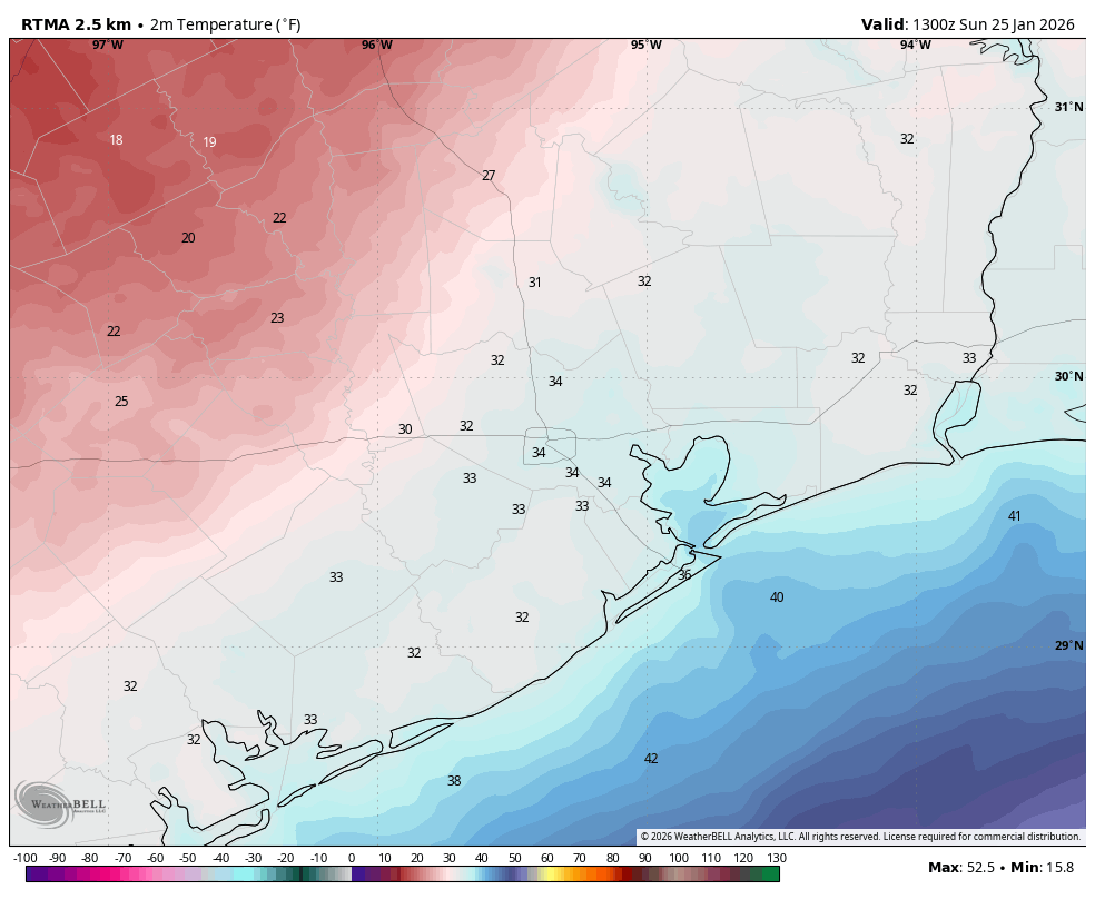
Basically, temperatures during the key moments of precipitation this morning across most of the Houston area remained in the 32 to 35 degree range. (The map above shows air temperatures at 7 am CT). We actually saw surface temperatures warm very slightly when the stronger showers moved through this morning as this heavier precipitation dragged some of the warmer air higher in the atmosphere down to the surface. These couple of degrees helped ensure that a lot of precipitation feel in Houston as cold rain or sleet. Moreover, because surfaces were still well above freezing (it’s been warm for the last week) there was not enough time for these surfaces to cool down to support sticking ice.
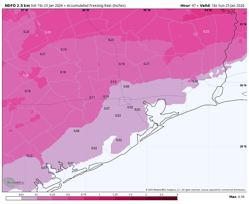
We received about 0.25 to 1 inch of precipitation this morning. Had that been snow, we would have had inches of the white stuff laying around. Had it been freezing rain, our roads would be an icy nightmare. Because it was what it was, our roads have had some time to dry out before temperatures plunge tonight.
Are there issues with driving?
Things are fine for the most part out there in metro Houston. As of noon on Sunday there are just about a dozen icy locations on area freeways, and these are largely where you would expect them: to the west, northwest, and north of Houston, mostly on overpasses. But by and large the rain has evaporated from streets before it could freeze, and a lot of area roads are clear. Locations that are dry now will be fine from now on.
There are still some locations with patchy ice, and areas with standing water will freeze tonight. So I’m not saying you should drive without caution. But getting around Houston should be fine if you drive with care tonight and on Monday.
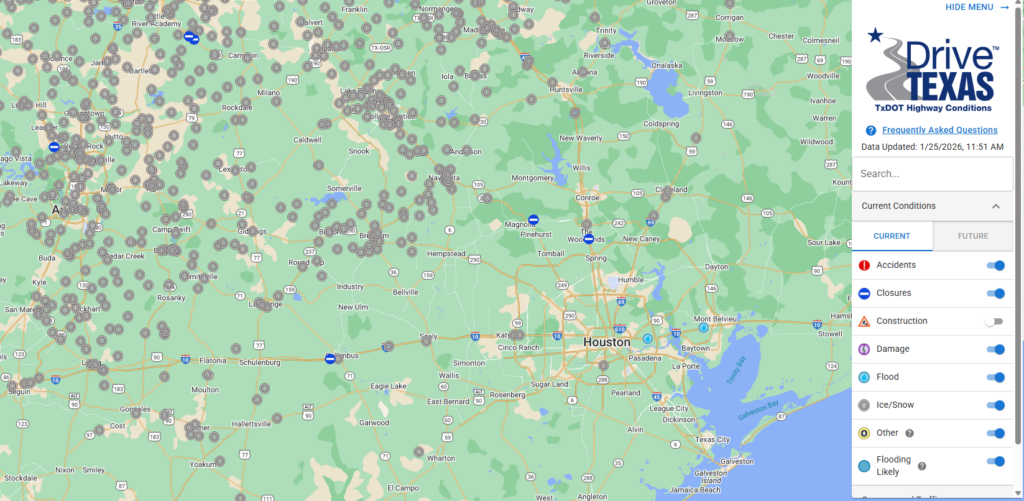
But boy oh boy, when you get outside of Houston conditions deteriorate pretty quickly. If you browse over to Drive Texas there are hundreds of reported incidences of ice and snow on Texas highways. So if you need to get from Houston north to Dallas, or west to Austin and San Antonio, travel is not recommended. (I-10 east into Louisiana is fine). Neither Austin nor Dallas will be comfortably above freezing until Tuesday, but road conditions may improve before then due to treatment.
So how about power issues?
Houston has dodged the first of two potential bullets when it comes to electricity. Because we never recorded much in the way of freezing rain this morning, ice never accumulated on tree limbs and power lines. Therefore, CenterPoint and other utilities never had distribution issues.
The second bullet is power generation, especially tonight into Monday morning when the state faces some of its coldest weather. If you peruse supply and demand projections from ERCOT, a possible crunch remains from 6 am to 10 am on Monday morning. So far ERCOT has not issued a call to conserve energy usage, so my sense is that things will be more or less OK on Monday morning from a power generation standpoint. But we’ll keep a close eye on things, and update Space City Weather if this projection changes.
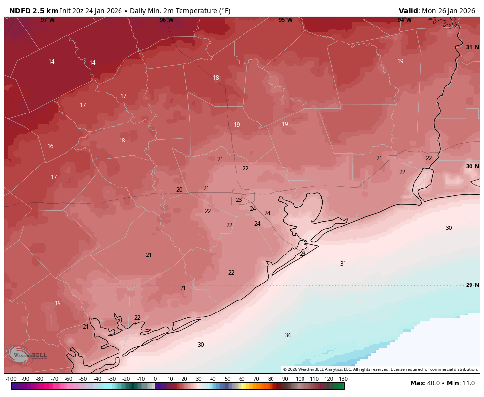
Sunday and Monday nights
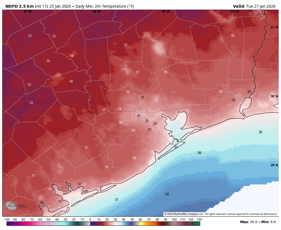
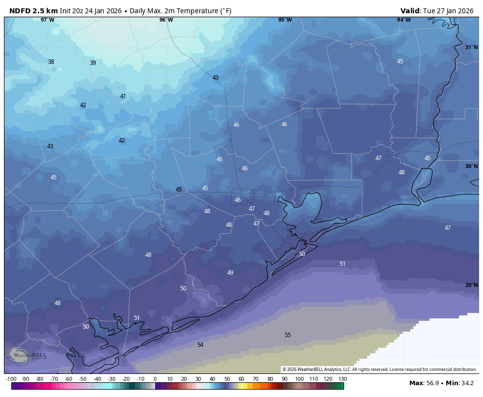
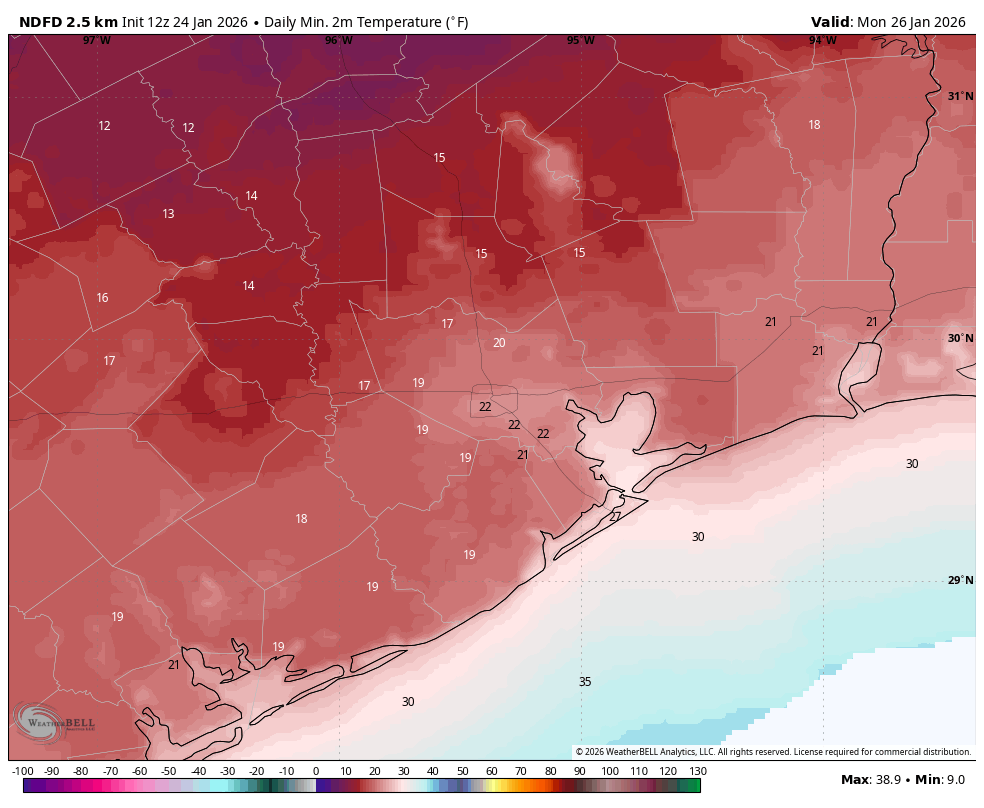
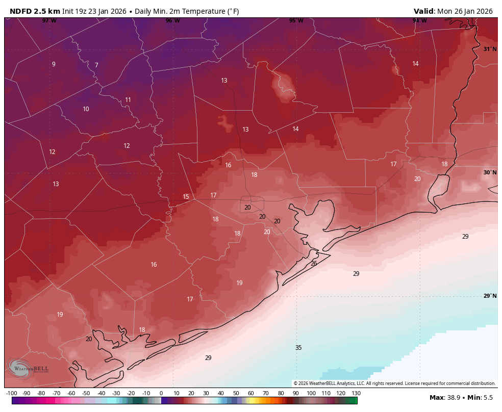
Our main remaining concern with this winter system is temperatures tonight and on Monday night, when the coldest air mass will be in place. Temperatures have trended slightly warmer of late, and I believe this is due in part to a lack of ice on the ground in and near Houston. This would have lead to more efficient cooling of air near the surface. I expect lows of generally 20 to 28 degrees in Houston on both nights, with slightly cooler temperatures possible north and west of the city. Below is a forecast for lows on Tuesday morning, which now should be the coldest of the period due to clear skies and light winds.
Our next update will be posted around 7 am CT on Monday morning.

It's time for rock palace with some really wild...
It's time for rock palace with some really wild air guitar!? #CowboyWho

Uh ... Excuse me there partner ... #CowboyWho
Uh ... Excuse me there partner ... #CowboyWho

Nature Sanctuary in stardew valley
ive been thinking of making a separate channel for gameplay videos, where i would showcase similar experiments like this. What do you think about that?
Get coding faster with Scrimba! Lots of solid free courses and use my link to save 20% on a Pro sub: https://scrimba.com/?via=EmergentGarden

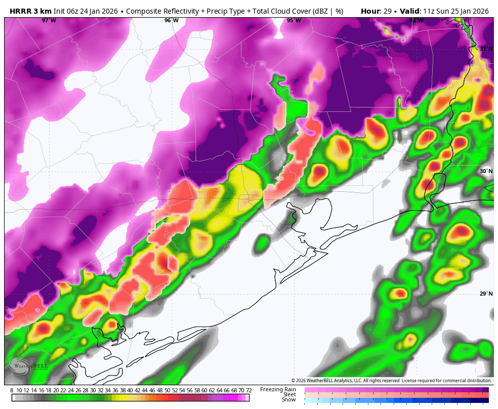
Forecast comes into better focus, with ice impacts likely for large parts of Houston on Sunday
In brief: The forecast for our winter storm is coming into clearer focus this afternoon, and we now anticipate fairly widespread ice impacts on Sunday, which may extend into Monday. There is also the potential for thunderstorms (and thundersleet!) before the precipitation ends on Sunday. It’s all happening in winter storm 2026 Houston.
What to expect, and when
For this afternoon’s post we are going to break things down into what people should expect, and when. Houston will face a mix of winter-inspired threats over the next two days, everything from thundersleet—yes, it’s a real thing—to ice on roads. The bottom line is that we all need to have a little patience over the next 24 to 48 hours until Mother Nature sorts its issues out.
Tonight
We’re already seeing temperatures falling into the upper 30s north of Houston, and this downward trend will continue. Freezing temperatures will arrive in places like Katy and The Woodlands around midnight tonight, and should move into much of the rest of the metro area (barring the coast) by sunrise on Sunday. During these overnight hours cold rain will transition to freezing rain and, in some cases, sleet. There is also the potential for some thunderstorms, in which case we might get a rare thundersleet sighting, in which sleet falls during a thunderstorm. In locations where sleet falls (which is preferable to freezing rain) there will be less ice buildup on streets. In any case, when you wake up Sunday morning we’re going to see a different world.
My baseline expectation is for 0.1 to 0.25 inch of ice accumulation along and inland of Highway 59/Interstate 69. As for areas south of this, and closer to the coast, we can probably expect a trace of ice perhaps up to 0.1 inch. The bottom line is that roads will potentially be hazardous anywhere but the immediate coast. Our best advice is to plan to stay home on Sunday, and limit any travel to emergencies only. Even if you are the world’s best ice road trucker, chances are your fellow drivers are not. For good real-time information about ice on Houston’s roadways, be sure to check Houston Transtar’s road incident page.
Sunday
It will be interesting to see how high temperatures get on Sunday. Parts of the area (again, most likely locations along and south of Highway 59) will probably get above freezing for a few hours on Sunday afternoon. This, in concert with gusty northerly winds, and potentially a some patches of sunny skies, may do some work on drying out roads. But then again, maybe not. And for areas further inland I’m just not confident in ice melting at all. I mean, it could happen. But if there’s enough ice, it will take longer than an hour or two of 35 degrees to take care of it. Temperatures will plunge back below freezing by 5 or 6 pm CT on Sunday, and we’ll be in for a cold night. However, the likelihood of clouds on Sunday night may take some of the edge off of low temperatures. I expect lows to remain in the vicinity of 20 to 25 degrees in urban Houston, with areas west (i.e. Katy) and north (The Woodlands) potentially dropping into the upper teens.
Monday
We’ve had the road discussion already, but I think freeways and local streets on Monday will be a mixed bag. Coastal areas probably will be OK. Areas further inland, probably not? I’m just not sure how well, or to what extent, our regional ice treatment services will do. I could see things being passable near downtown Houston and the Texas Medical Center, but I really want to see where we are on Sunday afternoon before making a definitive call. Anyway, we start out very cold on Monday, but with sunny skies I’m hopeful that most of the region gets to highs of 35 to 40 degrees. I think this, in concert with sunshine, should do work on icy roads. But again, I’m not 100 percent confident in that. Anyway, lows on Monday night (with clear skies) could be a degree or two colder than Sunday night.
Tuesday
If you’re wondering when you can stop worrying about this deep freeze, the answer is late Tuesday morning. By then temperatures will be recovering into the 40s.
Eric, what about the next Arctic front?
Yeah, we are probably going to see another cooldown next weekend. I think there’s a decent chance of a light freeze, and although we can’t rule out a hard freeze the signal for extreme cold is not nearly so strong as it was for the current event. There is also a signal for some snow, but we’re not going to make any promises to the kids just yet.
We will have one more update today, likely late this evening, by or before 11 pm to share our latest thinking on the forecast.
Almost gametime for freezing rain and sleet in the Houston area
In brief: The forecast for Houston remains on track overnight, as freezing temperatures enter the western fringe of Greater Houston. We expect periods of rain, freezing rain, and sleet overnight with falling temperatures and isolated thunder. Roads will likely be sloppy in spots, especially north and west of Houston. We encourage folks to heed the advice of local officials and stay off the roads tomorrow, at least until they can be evaluated and assessed.
Good evening everyone. I just want to shout out Eric for doing virtually everything himself this week, as I have been quite active with preparations for this storm. Winter storms are always challenging to forecast, and this one has been no different. But we’re almost into primetime now, so let’s look at where we stand heading into the overnight.
Temperatures
Generally, the entire Houston Metro area remains above freezing as of 10:45 this evening. Outlying areas west of the city are dropping below freezing now, particularly near Sealy, Bellville, Navasota as examples.
Temperatures will continue to drop, with the freezing line probably entering the western Metro area around 1 AM or so, the I-45 corridor north of I-10 around 3-4 AM, and the Inner Loop by 7 AM. Note that the freezing line will push farther south than it will east faster, so places like Bay City and Wharton will drop below freezing before places like Humble as an example.
Then on Sunday, expect temperatures to hold near freezing all day from Houston north and west and probably around 32 to 34 degrees south and east.
Freezing rain & sleet
The area has been in a lull this evening with sprinkles, drizzle, fog, mist, a couple showers, but nothing else really. That will change over the next few hours. Expect showers to become more numerous in the area with a period of moderate to heavy precipitation arriving in the Houston area between 1 and 6 AM. It won’t be precipitating heavily during that entire time, but there will be areas that see moderate rain and freezing rain or even moderate sleet as well.
The heaviest of the precipitation will thankfully pass to our north. However, it will be this area of rain or freezing rain or sleet that begins to cause problems on area roadways. This will be especially true north and west of Houston. I think most places are going to see around 0.10 of ice or perhaps a bit less, especially if sleet overtakes freezing rain as the dominant form of precipitation. There will likely be patches in northern Wharton, Austin, Waller, Fort Bend, western Harris, Montgomery, Walker, Grimes, and Washington Counties that see perhaps 0.1 to 0.2 inches of ice. At those levels, we’ll almost certainly see very slick bridges and overpasses, as well as freeway flyovers. Surface streets will take a little longer to freeze, but I would expect patchy black ice on area roads late tonight and Sunday morning.
In addition to the precipitation, there will likely be at least a few lightning strikes overnight. With a wicked temperature inversion (temperatures warming with altitude), some of that thunder may be extra loud. I don’t think the excitable dog index gets much higher than a 2 or 3 out of 10 due to mostly isolated strikes.
The message we’ve been echoing from our local elected officials and emergency management agencies is that we strongly advise you stay off the roads overnight and on Sunday morning. Let officials check the situation out in the morning. If it’s not as bad as feared, wonderful. But if it’s a slopfest, we need to keep those roads wide open for first responders who also will need to slow down and drive carefully. Stay safe.
Other notes
Winds will be blustery on Sunday. Expect gusts of 20 to 25 mph creating wind chills in the teens, especially in the afternoon. I am not optimistic that we’re going to see much sunshine tomorrow. In fact, the cloud cover may linger into tomorrow night helping keep temperatures milder than forecast, likely in the mid-20s in most of the metro area. We should see the sun return by Monday afternoon. With clearer skies, it’s plausible that Tuesday morning will actually be colder than Monday in Houston, not by a ton but at least a little bit. You’ll want to maximize your cold weather protections through Tuesday.
Eric will be up early on Sunday to give you an update on the latest. Stay safe, and stay warm!
Showers moving through Houston this morning, followed by Arctic air tonight and potential for freezing rain
In brief: In today’s post we dive into the timing for a second round of precipitation tonight, and when and where that is likely to transition over to freezing rain and sleet. Additionally, cloud cover is complicating the forecast for lows on Monday morning.
Precipitation overview
As of 6:30 am CT on Saturday we are seeing widespread showers, and a few thunderstorms, moving through the region. This was entirely expected, and will drop between 0.5 and 2 inches of rain for most locations. These rains are actually rather beneficial given our region’s ongoing drought, and since temperatures today will remain above freeze there is no threat of ice from them. The main mass of these showers should exit the region to the east by around 9 am, with a few lingering showers possible later this morning and into the afternoon.
Then, later this evening, another round of showers will move in from the west, and persist sporadically overnight into Sunday morning. These will exit to the east by mid-morning on Sunday. This second round of precipitation could drop 0.5 to 1.0 inch of water. Now, the question is if and when this rain on Saturday night and Sunday morning transitions over to freezing rain.
For areas along and north of Highway 105, which includes places such as College Station, Navasota, Conroe, and other locations, this transition could occur as early as 7 pm and 10 pm on Saturday evening. A little closer to the Houston metro area, for places such as Katy and The Woodlands, this transition (should it occur) will happen a little later, perhaps between 10 pm Saturday and 2 am on Sunday. Then, after midnight, we are likely to see a mix of rain, freezing rain, and possibly sleet in central areas such as Sugar Land, urban Houston, Kingwood, and so on; basically areas along and inland of Highway 59/Interstate 69. For areas closer to the coast is is possible this line of freezing rain/sleet transition continues, or it may remain just warm enough to preclude the formation of freezing precipitation.
In any case, when you wake up on Sunday morning, you will want to pay very close attention to road surfaces. For central and northern Houston there is a reasonable likelihood of a light sheen of ice, which will make driving hazardous.
Sunday
Most of the area will start out on Sunday with temperatures around freezing, perhaps a degree or two below or above. One important question is whether air temperatures rise much. I’m starting to think the answer is probably not, because skies are now likely to remain mostly cloudy during the daytime. It is therefore possible that any ice that has accumulated on roads (which again, is likely to have occurred in many locations along and north of Highway 59, and possibly further south) will stick throughout the day. However if temperatures do rise above freezing some of this ice may melt, especially with the aid of northerly winds to dry roads. Speaking of those winds, they will represent the full surge of Arctic air moving in, likely gusting up to 25 or 30 mph on Sunday afternoon. This means it will be very cold outside, even during the daytime. Temperatures on Sunday night will be tricky, because if clouds linger it will provide some limited “insulation.” Accordingly I think low temperatures in Houston will likely fall into the 20 to 25 degrees range, with upper teens to lower 20s possible to the west (Katy and beyond) and north (Spring and Kingwood) and beyond.
Monday
Ok, so will there be ice on the roads on Monday? Will the airports be effectively shut down? Will you have to go to work or school? This is the question everyone wants answered, and I don’t have anything definitive for you (except for some schools that have already shut down). I think, for at least parts of the Houston metro area, there will be ice issues on roads. It may be regional. For example, Bush Intercontinental Airport might be iced in (such that workers cannot get there) whereas Hobby Airport has more passable roads. But honestly, we could see any scenario from very limited ice impacts (excepting elevated roads and bridges) across Houston to pretty widespread impacts on Monday morning. We probably won’t have a definitive answer on this until Sunday, when we see how much ice has accumulated, and what temperatures that afternoon do. I know, I know, that’s not particularly helpful.
We do expect the return of sunshine on Monday, which is great because it should allow afternoon temperatures to rise into the 35 to 40 degree range, helping to clear roads in most locations, hopefully even our far northern areas along Highway 105. We’ll see about that. The downside of the clearing skies is that they will bring another very cold night into the city, with temperatures likely on par with Sunday night. So a hard freeze for many, if not most locations.
The rest of next week
Tuesday, Wednesday, and Thursday of next week should be comfortably in the upper 40s and then early 50s for daytime temperatures. We still might see some light freezes, but nothing too concerning after this weekend’s mess. We should see a decent amount of sunshine. There is the potential for another Arctic front next weekend, but at this time I’m not sure Houston will see a direct shot of the coldest air. So I’m hopeful that we won’t see temperatures drop significantly below freezing. However, we’re not ruling anything out, including the possibility of a wintry mix remix. For now there’s way too many unknowns to say anything intelligent about such a forecast, however.
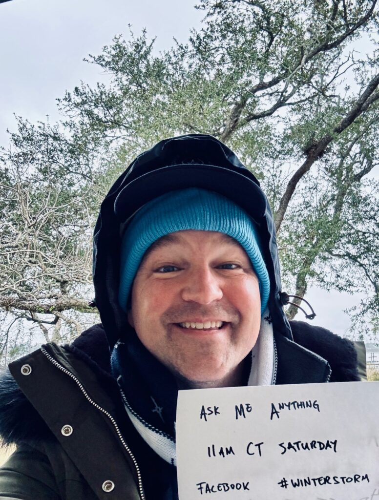
Saturday Q&A
I’m going to do another Q&A with readers on Facebook at 11 am CT today, so bring your most difficult weather questions and I’ll do my best to answer them. We will once again share the most commonly asked questions here, along with the answers, in a follow-up post.
Our next full update after this will be published around 3 pm this afternoon.
Retail News: Joe V’s is coming to Humble!

Here’s what we know, and what we don’t about the impending deep freeze
In brief: In today’s post we discuss the ongoing forecast with a winter storm that is due to arrive in Houston about 36 hours from now. With this update we list some things we know, and some we don’t about the forthcoming freeze.
Overview
Good afternoon. We are about a day and a half from freezing temperatures descending into the Houston metro area. Not much has changed with our overall forecast. Area roadways should be fine through Saturday evening, but by early Sunday we have questions and concerns. At this point I’m a little more bullish on ice in the Houston metro area, so I am leaning a little more toward a disruptive event on Sunday and possibly Monday morning, especially for locations north of Interstate 10. But it is far from a done deal.
We also still have questions about how cold temperatures will get on Monday and Tuesday mornings. I would ballpark lows at about 20 degrees in urban Houston (a little cooler for inland sites such as Katy, Tomball, The Woodlands, and Kingwood) and a little warmer for locations closer to the coast, such as League City. But there is the possibility those temperatures are too low. Anyway, on to what we know, and what we don’t.
We know: If you need to make a closure decision now, err on the side of caution
I’m still not sure what Houston’s roads will look like on Sunday morning, later in the day, and on Monday morning. Following precipitation on Sunday morning, which could fall as freezing rain or cold rain, we could be anywhere from “bone dry” to “icy bridges and overpasses” to “widespread ice” by Sunday afternoon. I know this is a huge cop-out, but it’s the truth due to uncertainty about air temperatures on Sunday. Anyway, we’ve already seen decisions by the Houston Independent School District and a handful of other districts to close on Monday. This is understandable, given the uncertainty. If you can’t wait to make a closure decision, that’s prudent. If you can wait, there’s still a chance things will be mostly fine on roads.
We don’t know: What will happen with electricity?
There are two issues with getting electricity into your home. The first of these is generation. This was the killer during the February 2021 winter storm, when large chunks of the Texas power grid were taken offline due to plants shutting down. If you’re like me, you’ve been periodically checking the “supply and demand” projection from ERCOT. Everything looks more of less fine, but there does appear to be a potential supply crunch on Monday morning, around sunrise, when temperatures are at their coldest.
The other issue is distribution, with the main concern in ice accumulating on tree limbs and power lines, causing them to snap. CenterPoint Energy, which is responsible for distribution in the greater Houston area, says they are making all necessary preparations. The bottom line is that I don’t expect to see the extreme and disastrous power losses experienced during the winter storm of 2021. But that’s not to say there won’t be some disruptions in service.
We know: People are panic shopping
I’ve heard from people, and can see from social media, that y’all are raiding grocery stores for all manner of supplies. (Pro tip: Kroger appears to be less crowded than HEB). But you don’t need to stock up forever, friends. Regardless of what happens, roads will very likely be passable on Monday afternoon, and at the very worst Tuesday when we’re back up into the 40s.
We don’t know: How low will temperatures go?
Forecasting low temperatures is difficult during winter events like this. One factor is ice. If there is a lot of it covering areas north of Houston, and within the city itself, than northerly winds moving over this ice will cool down more efficiently. This will lead to colder temperatures (possibly teens) in and around Houston. However it is also plausible that much of the city only drops to about 25 degrees. Our best advice is to prepare for the colder temperatures, and hope for “warmer” conditions.
We know: Thunderstorms are possible on Saturday
A decent line of thunderstorms will pass through Houston on Saturday morning, likely during the mid-morning hours. Thunderstorms will be more likely along and south of Interstate 10 and closer to the coast. These could drop 1 to 2 inches of rain pretty quickly, so keep that in mind as part of your winterization preparations. After these storms pass I expect a lull in rain (for the most part) as temperatures drop into the 40s on Saturday afternoon. A second round of showers will likely spin up early on Sunday and persist into the mid-morning hours.
We don’t know: How airports will be affected
I know, you have flight questions. I wish we had answers. Flying on Saturday should not be problematic, but it’s difficult to say the same about Sunday and possibly Monday morning. Of note, many airlines have issued waivers for change fees for today through Monday.
We know: Space City Weather does not use made up storm names
The Weather Channel, as it has done for more than a decade, has named the impending winter storm “Fern.” These names are not official, and there is no significant evidence they do anything to enhance safety. Also, “Fern” is a pretty dumb name for a storm. So we won’t be using it (just like we have never used “Uri” for the 2021 deep freeze).
Our next update will be posted by 7 am CT on Saturday. I will also be doing an additional Q&A at 11 am tomorrow on our Facebook page. Thanks for your patience as we work through a difficult forecast here.
Saturday Morning Breakfast Cereal - Trad

Click here to go see the bonus panel!
Hovertext:
For the record, I am copyrighting this lifestyle. Anyone doing it owes me one (1) banjolele.
Today's News:
 ALT
ALTDOJ Admits DOGE Team Caught Sharing Social Security Data With Election Denier Group
We spent a lot of time last year calling out how dangerous it was that Elon Musk and his inexperienced 4chan-loving DOGE boys were gaining access to some of the most secure government systems. We also highlighted how it seemed likely that they were violating many laws in the process. One specific point of concern was DOGE’s desire to take control over Social Security data, something that many people warned would be abused for political reasons, in particular to make misleading or false claims about voting records.
For all the people who insisted that this was hyperbolic nonsense, and DOGE was just there to root out “waste, fraud, and abuse,” well… the DOJ last week quietly admitted that the DOGE boys almost certainly violated the Hatch Act and had given social security data to conspiracy theorists claiming Trump won the 2020 election (he did not).
Oh, and this only came out because the DOJ realized it had lied to a court (they claim it was because the Social Security Administration officials had given them bad info, but the net effect is the same) and had to correct the record.
Shapiro’s previously unreported disclosure, dated Friday, came as part of a list of “corrections” to testimony by top SSA officials during last year’s legal battles over DOGE’s access to Social Security data. They revealed that DOGE team members shared data on unapproved “third-party” servers and may have accessed private information that had been ruled off-limits by a court at the time.
Shapiro said the case of the two DOGE team members appeared to undermine a previous assertion by SSA that DOGE’s work was intended to “detect fraud, waste and abuse” in Social Security and modernize the agency’s technology.
From the actual filing in the case:
Also in his March 12 declaration, Mr. Russo attested that, “[t]he overall goal of the work performed by SSA’s DOGE Team is to detect fraud, waste and abuse in SSA programs and to provide recommendations for action to the Acting Commissioner of SSA, the SSA Office of the Inspector General, and the Executive Office of the President.”….
However, SSA determined in its recent review that in March 2025, a political advocacy group contacted two members of SSA’s DOGE Team with a request to analyze state voter rolls that the advocacy group had acquired. The advocacy group’s stated aim was to find evidence of voter fraud and to overturn election results in certain States. In connection with these communications, one of the DOGE team members signed a “Voter Data Agreement,” in his capacity as an SSA employee, with the advocacy group. He sent the executed agreement to the advocacy group on March 24, 2025.
The filing goes on to admit that the declaration from a Social Security administration employee that there were safeguards in place against sharing data, and that everyone had received training in not sharing data, was apparently wrong.
However, SSA has learned that, beginning March 7, 2025, and continuing until March 17 (approximately one week before the TRO was entered), members of SSA’s DOGE Team were using links to share data through the third-party server “Cloudflare.” Cloudflare is not approved for storing SSA data and when used in this manner is outside SSA’s security protocols. SSA did not know, until its recent review, that DOGE Team members were using Cloudflare during this period. Because Cloudflare is a third-party entity, SSA has not been able to determine exactly what data were shared to Cloudflare or whether the data still exist on the server.
Cool cool. No big deal. DOGE boys just put incredibly private data on a third party server and no one knows what data was there or even if it’s still there.
Have I got some waste, fraud, and abuse for you to check out!
Separately, the filing reveals that Elon Musk’s right hand man, Steve Davis—the “fixer” Musk deploys across all his organizations—was copied on an email containing an encrypted file of SSA data. The filing is careful to note that DOGE itself “never had access to SSA systems of record,” but that’s a distinction without much difference when your guy is getting emailed password-protected files derived from those systems. Oh and: SSA still can’t open the file to figure out exactly what was in it.
However, SSA has determined that on March 3, 2025—three weeks prior to entry of the TRO—an SSA DOGE Team member copied Mr. Steve Davis, who was then a senior advisor to Defendant U.S. DOGE Temporary Organization, as well as a DOGE-affiliated employee at the Department of Labor (“DOL”), on an email to Department of Homeland Security (“DHS”). The email attached an encrypted and password-protected file that SSA believes contained SSA data. Despite ongoing efforts by SSA’s Chief Information Office, SSA has been unable to access the file to determine exactly what it contained. From the explanation of the attached file in the email body and based on what SSA had approved to be released to DHS, SSA believes that the encrypted attachment contained PII derived from SSA systems of record, including names and addresses of approximately 1,000 people.
Looks like some more waste, fraud, and abuse right there.
So to recap: the team that stormed in to root out “waste, fraud, and abuse” committed what looks an awful lot like actual fraud and abuse—sharing data on unauthorized servers, misleading courts, cutting deals with election conspiracy groups, and emailing around encrypted files of PII that the agency itself can’t even open anymore. All of it now documented in federal court filings—not that anyone will do anything about it. Accountability is for people who don’t have Elon Musk on speed dial.
Entire French Populace Moved To Tears By Cartoon Of Robot Holding Flower
PARIS—Clutching their chests in wonder at the newly unveiled work by an anonymous street artist, all 68 million members of the French populace were reportedly brought to tears Friday by a cartoon of a robot holding a flower. “Technology has made us into zombies, and yet here is a robot showing us the truth,” said 43-year-old Clémence Lefèvre, echoing the sentiment of the entire French populace, whose economy ground to a halt as millions of police officers, nannies, mimes, pastry chefs, priests, and rebellious beatniks alike abruptly stopped their affairs to march down the Champs-Élysées and raise their voices as one to thank the robot. “This work is, how do you say…transcendent. It expresses an emotion beyond love and despair, for it is a reflection of love and despair itself. It is subversive like the art of Marcel Duchamp, and yet universal, speaking to all who suffer from ennui and an addiction to their phone. This is better than any work in that bourgeois temple of uninspired slop, the Louvre. Mon Dieu, what have we done to Mother Earth?” At press time, an elderly farmer in a horse-drawn wagon was reported to have rolled up to the cartoon, wordlessly placed his hand on the robot’s heart, and collapsed into a peaceful death.
The post Entire French Populace Moved To Tears By Cartoon Of Robot Holding Flower appeared first on The Onion.
Trump Boys Put Nobel Peace Prize In Microwave
WASHINGTON—Checking to see if the prestigious award was real by placing the medal on the glass turntable and hitting the potato button, Eric Trump and Donald Trump Jr. reportedly microwaved the 2025 Nobel Peace Prize on Friday. “Look, look, I think it’s starting to melt!” said Don Jr., the eldest Trump boy, who pressed his face against the door of the appliance to watch the gold medal slowly rotate as his younger brother begged for his turn to watch. “Bye, bye Abraham Lincoln! We’re going to turn you into slime, and then the Hotel Prize in Appliance [sic] will be ours. Wait, what’s happening?” At press time, sources reported the sobbing Trump boys were telling their father they had no idea how the Nobel Prize got into the fiery microwave.
The post Trump Boys Put Nobel Peace Prize In Microwave appeared first on The Onion.
Katy Perry’s Friends Skeptical Of Alleged Powerful Boyfriend Who Lives In Canada
LOS ANGELES—Saying they wished she would just be honest with them, friends of multiplatinum recording artist Katy Perry expressed skepticism this week about her alleged powerful boyfriend who lives in Canada. “Katy keeps going on and on about this new guy, but every time one of us asks when we’ll get to meet him, she just says he’s a really important person in Canada,” said friend Emily Curry, who noted that she first became suspicious after she asked Perry to see a photo of her new beau and was shown a picture that looked suspiciously like it had been pulled from Google images. “I called her last week, and she tried telling me the connection was bad because she and her boyfriend were out on a yacht. Sure, Katy. I don’t know why she feels the need to lie. This is just like when she came back from vacation and told us she had been singing in outer space.” Curry added that the alleged Canadian boyfriend was almost as far-fetched as Perry’s so-called “movie star” ex, who supposedly lives in England.
The post Katy Perry’s Friends Skeptical Of Alleged Powerful Boyfriend Who Lives In Canada appeared first on The Onion.
Artist Profile: A$AP Rocky
Rapper A$AP Rocky has released Don’t Be Dumb, his first album in eight years. The Onion shares everything you need to know about the artist.
Genre: Brand collaboration
Famous Relatives: Rihanna’s kids
Biggest Career Risk: Nodding off during Smurfs premiere
Citations From Massachusetts Department Of Fish And Game: Three
Personal Style: Businessman who sprinted through a silk scarf store
Favorite Thing To Do On Phone: Press “1” to confirm Rihanna’s ob-gyn appointment
Recurring Nightmare: Looking down and realizing he showed up to the Met Gala completely naked
Review Of Sweden: Good food, weird locals, three stars
The post Artist Profile: A$AP Rocky appeared first on The Onion.
‘House Burping’ Gains Popularity In U.S.
The trend of “house burping,” based on the German practice of “lüften” or briefly opening windows to refresh indoor air, has taken off in the U.S., with proponents claiming the practice improves air quality. What do you think?

“Am I the only one milking my apartment?”
Jenna Ainsworth, Corn Shucker

“But that lets all the Febreze out.”
Deon McKenna, Shelf Organizer

“No need to complicate things. Just move to a fresh house every three days.”
Mark Laury, Aeronautic Sociologist
The post ‘House Burping’ Gains Popularity In U.S. appeared first on The Onion.