Shared posts

01 Jul 16:08

Cultural Differences in Map Data Visualization

Matthew Panzarino had an interesting article in TechCrunch on Apple’s process for rebuilding their Maps app. While most of the article describes the laborious process of data collection, one part jumped out at me, which was the team that Panzarino describes as the “Department of Details.” They are responsible for a number of odds and ends regarding how maps are presented, but they are particularly concerned with presenting maps to people around the world.

The maps need to be usable, but they also need to fulfill cognitive goals on cultural levels that go beyond what any given user might know they need. For instance, in the U.S., it is very common to have maps that have a relatively low level of detail even at a medium zoom. In Japan, however, the maps are absolutely packed with details at the same zoom, because that increased information density is what is expected by users.

What struck me is that I’ve never heard much discussion in the statistics data visualization literature about cultural differences in data perception. My assumption all along was that there would be perception theory that would try to determine the “optimal” data density for a given level of zoom (for example), based on metrics of, say, remembering certain features, or reasoning about what is seen. The idea that whatever the optimal density is might depend on the cultural background of the viewer is new to me.

I’ll be the first to admit that I’m not terribly familiar with the literature on data visualization and perception. But I’d be happy to accept pointers to where this has been studied more thoroughly.

01 Jul 15:56

Pedestrians vs Drivers

So often these days the debate is framed as "drivers vs cyclists" or "drivers vs pedestrians". Basically drivers vs everyone. Because if there's one thing we've learnt is that drivers think all the roads, parking spaces and infrastructure is all for them and absolutely no-one else.

But you need to walk to get into a car. You need to get out of a car to walk when you get to your destination. Everyone becomes a pedestrian at some point. In fact everyone in a car gets out of a car, eventually.

So you can have a world where people go into their garages at their houses, drive to work and go into their garages there ... and no-one ever interacts with anything other than cars in the real world. Or perhaps you can treat pedestrians with respect. And people on bicycles. And just about everyone else.

01 Jul 15:56

A TURN Server for Nextcloud Talk

by Martin

Over the past few weeks, I’ve been using Nextcloud Talk quite a bit. While I’m very happy with it in general, I have actually found two scenarios in which the standard setup is not able to establish a connection between the two (or more) parties of a call: In roaming scenarios with my mobile network operator of choice and when I use Nextcloud Talk in the web browser on the PC at work behind the firewall. But there is a fix, at least for one of them.

So What’s the Issue?

In the default setup, Nextcloud talk uses the WebRTC framework to establish direct IP connectivity between all parties in a call. As most devices today are behind NATs or firewalls, this requires NAT pin-holing and other techniques to get those packets flowing directly. If this fails, Nextcloud Talk will fail as it doesn’t have a server in the middle by default that could terminate the media path of each side.

The Mobile Scenario That Doesn’t Work

While using Nextcloud Talk on a mobile device and via tethering on my notebook worked well at home, I could not establish a connection when I was recently roaming abroad for a few days. I was a bit puzzled at first but found the issue pretty quickly: While at home, my mobile device is configured for IPv4/v6 dual-stack connectivity. When roaming abroad, however, connectivity is by default limited to IPv4 only. In my home network scenario, Nextcloud Talk worked because it used IPv6 for a direct connection. When abroad, it tried to do the same with IPv4. Unfortunately, the IPv4 NAT of my mobile network operator seems to be unpredictable and thus the direct connection to the other end could not be established.

The Fix…

The only way to get around unpredictable NATs is to use a man-in-the-middle server somewhere on the Internet that terminates each call leg. This way, no NAT pin-holing is required, and each end sends and receives its IP media packets to/from the server with a public IP address. It’s not ideal but still secure as WebRTC does end-to-end encryption of the media stream. The standard way of doing this is using a TURN (Traversal Using Relays around NAT) server for this. Fortunately, there are open source implementations of the standard that can be installed and configured quite easily. By using the instructions I found here, I was able to get things up and running in less than 30 minutes! A quick call over tethering before and after setting up the TURN server confirmed that this was indeed the fix for my mobile scenario. When tracing connectivity it is interesting to observe how the local WebRTC client tries many different things to get a direct or indirect connection to the other end simultaneously and uses the first connection that actually works.

The Company Firewall Scenario

Unfortunately, the TURN server did not help to also get the call working from the PC at work behind the company firewall. I had high hopes and even used port 80 and 443 for the TURN server but no luck there. A bit of a shame as products such as Webex and others can handle this scenario as well.

But still, my most important connectivity scenarios are covered now!

01 Jul 15:56

Nokia 7 plus :: A couple of weeks in

by Volker Weber

IMG 3786

Executive summary: I really like this phone.

Let's not beat around the bush: I use an iPhone X, and there is no other phone that could replace it, short of an even better iPhone. If anybody asks me, I would always recommend to get an iPhone, especially if you have the funds to afford one. That rules out a couple of high end Android "flagship" phones.

But what if you want to spend considerably less and still get a really great smartphone. In that case, seriously consider this phone. I have used it for a couple of weeks as backup and it has survived against strong competition in the Android space. I never bothered to put it into a protective sleeve, even though there is a protective clear TPU case in the box. It's just not slippery and I have not dropped it once. I don't care much for zero bezels, curved screens or other 2018 items on the checklist.

Yes, the main camera could use some software improvements, which you can witness if you try the Google camera instead of the Nokia one. But even with the Nokia camera I shot some great photos. And the selfie camera is outstanding, if that is your thing.

Techaltar is a bit undecided. On one hand, he really likes his Nokia 7 plus, but then he says he wants a better camera and maybe smaller bezels.

Jerryrigeverything finds it quite durable.

01 Jul 15:55

South Central Summerside

by peter@rukavina.net (Peter Rukavina)
01 Jul 15:55

Walking 100 km in a week #dontbreakthechain

by Volker Weber

41c716e4d1a6d9760d50baf1b7891ed8 2e72f49a5d087eebe4f5444b50453c4f

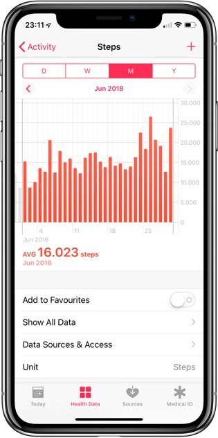
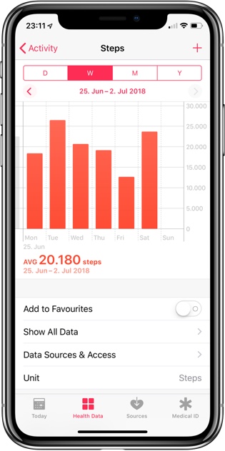
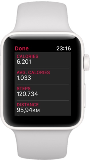
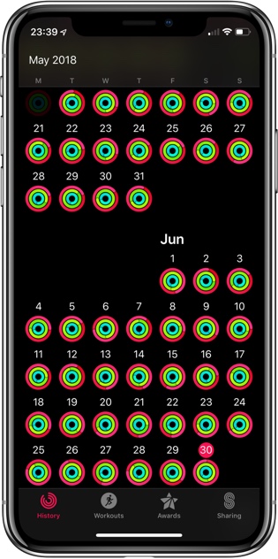
I needed to go from cycling back to walking. I just did not feel strong enough in my legs. So I set out to do 100.000 steps for three weeks in June, and then 100 km in the final week. I figured I would need a few weeks to build up muscle that I could use in the final week. This worked out OK. Yesterday I was feeling sick all day so I could only put in my steps in the evening.

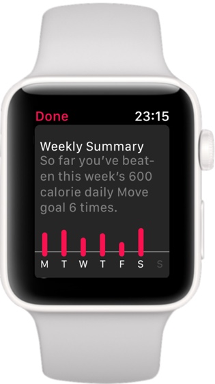
14.300 steps a day takes you over 100.000 steps a week, but you need 18.000 a day to get past 100 km. I could have raised my daily move goal from 600 to 1000 but I did not want to put on too much pressure.

2428469b595a62a82d999f8d3bab96d6 fa85ab4029e81d407f28488857ec8ce9

I think I should be able to walk 4060 meters to complete the 100 km tomorrow before breakfast. :-)

adeca4a1c32aab6306583d83f5a7a18f 4bd43c7a16a71f7a4959a1eae95a68b0

While I completed all rings every day of the month, I "only" earned the June challenge of completing them 29 times, but have yet to receive the full month. I am also missing a few 200% awards, including yesterday where I did 1200 instead of 600. And I still have that weird hole over three days in May. Good news though. Apple fixed the tally for my weeks with all rings completed. It no longer reads more weeks than Apple Watch has been on the market. It's getting better!

BTW: Did you catch the off-by-one error in the second screen shot. The week ends on 1. Jul. 2018 not 2. Jul. 2018.

01 Jul 15:50

Twitter Favorites: [mathowie] Consider the RSS Consider its ease We use every part of the RSS It’s all we need We make podcasts from enclosures… https://t.co/gOgFGnG9qt

Matt Haughey @mathowie
Consider the RSS Consider its ease We use every part of the RSS It’s all we need We make podcasts from enclosures… twitter.com/i/web/status/1…
30 Jun 04:18

Harlan Ellison was a God damned pain in the ass. I’ll miss him.

by Josh Bernoff

The writer Harlan Ellison died yesterday. He was a brilliant, irritating, iconoclastic, inflexible force of nature. I cannot imagine him being 84 years old, and death is exactly the sort of inconvenience he’d never put up with. Harlan (everyone just called him “Harlan”) began his writing career by joining a street gang, undercover, and then … Continued

The post Harlan Ellison was a God damned pain in the ass. I’ll miss him. appeared first on without bullshit.

30 Jun 04:17

Working With OpenStreetMap Roads Data Using osmnx

by Tony Hirst

A couple of days ago, I came across the incredible looking osmnx Python package, originally created by Geoff Boeing at UC Berkeley in support of his PhD, via one of his blog posts: OSMnx: Python for Street Networks (there is a citeable paper, but that’s not what I originally found…) There are also some great example notebooks: gboeing/osmnx-examples.

I spent a chunk of today having a play with is, and have posted a notebook walkthrough here.

It’s quite incredible…

Pretty much a one-liner lets you pull back all the roads in a particular area, searched for by name:

The osmnx package represents routes as a networkx graph – so we can do graphy things with it, like finding the shortest distance between two points, aka route planning:

The route can also be plotted on an interactive map. An option lets you hover on a route and display a context sensitive tooltip, in this case the name of the road:

Retrieving routes by area name is handy, but we can also pull back routes within a certain distance of a specified location, or routes that are contained within a particular region specified by a shapefile.

In a previous post (Trying Out Spatialite Support in Datasette) I showed how to put Ordnance Survey BoundaryLine data into a SpatiaLite database and then access the geojson boundary files from a datasette API. We can use that approach again, here wrapped up in a dockerised context:

Using the retrieved boundary shapefile, we can then use osmnx to just grab the roads contained within that region, in this case my local parish:

Once again, we can use an interactive map to display the results:

If we overlay the parish boundary, we see that the routes returned correspond to the graph between nodes that lay within the boundary. Some roads pass straight through the boundary, others appear to lay just outside the boundary.osmnx_Demo11

However, it looks like we can tweak various parameters to get the full extent of the roads within the region:

osmnx_Demo12

As well as routes, we can also get building footprints from OpenStreetMap:

If you know where to look, you can see our house!

Building footprints can also be overlaid on routes:

If we generate a distance to time mapping, the graph representation means we can also colouring nodes according to how far in walking time, for example, they are from a particular location:

We can also overlay routes on isochrone areas to show travel times along routes – so where’s within half an hour’s walk of the Pointer Inn in Newchurch?

Living on a holiday island, I wonder if there’s any mileage (!) in offering a simple service for campsites, hotels etc that would let them print off isochrone walking maps centred on the campsite, hotel etc with various points of interest, and estimated walking times, highlighted?

I’m also wondering how much work would be required in order to add additional support to the osmnx package so that it could use Ordnance Survey, rather than OSM, data?

And finally, one other thing I’d like to explore is how to generate tulip diagrams from route graphs… If anyone has any ideas about that, please let me know via the comments…

PS for building outlines in the UK derived from Ordnance Survey data, see for example Alasdair Rae’s OS OpenMap Local – All Buildings in Great Britain.

PPS And building footprints for the US, courtesy of Microsoft: https://github.com/Microsoft/USBuildingFootprints


30 Jun 04:17

Apple is Rebooting Its Maps App with Rebuilt Map Data

by John Voorhees
Source: TechCrunch

Source: TechCrunch

Next week, Apple will begin rolling out new map data as part of the iOS 12 beta. The company, which provided an extensive preview to Matthew Panzarino at TechCrunch, has been rebuilding its map data from the ground up, relying on its own data collection instead of third-party providers.

As a part of the preview, Panzarino interviewed Senior Vice President, Eddy Cue, Vice President Patrice Gautier, and ‘over a dozen’ members of the Apple Maps team. According to Cue, the process of rebuilding Maps began four years ago. Cue told TechCrunch that instead of relying on a patchwork of data sources from third-party vendors, Apple decided to leverage a combination of sources in its control, including the millions of iOS devices in service around the globe:

“We felt like because the shift to devices had happened — building a map today in the way that we were traditionally doing it, the way that it was being done — we could improve things significantly, and improve them in different ways,” he says. “One is more accuracy. Two is being able to update the map faster based on the data and the things that we’re seeing, as opposed to driving again or getting the information where the customer’s proactively telling us. What if we could actually see it before all of those things?”

So, Apple began collecting map data in 2015 from a combination of dedicated Apple Maps vans, high-resolution satellite imagery, and what Apple calls probe data from iOS devices, all supplemented by hundreds of human editors. Panzarino, who took a ride in one of the Apple Maps vans, describes the tech they use:

In addition to a beefed up GPS rig on the roof, four LiDAR arrays mounted at the corners and 8 cameras shooting overlapping high-resolution images – there’s also the standard physical measuring tool attached to a rear wheel that allows for precise tracking of distance and image capture. In the rear there is a surprising lack of bulky equipment. Instead, it’s a straightforward Mac Pro bolted to the floor, attached to an array of solid state drives for storage. A single USB cable routes up to the dashboard where the actual mapping capture software runs on an iPad.

He also describes the probe data as:

Essentially little slices of vector data that represent direction and speed transmitted back to Apple completely anonymized with no way to tie it to a specific user or even any given trip. It’s reaching in and sipping a tiny amount of data from millions of users instead, giving it a holistic, real-time picture without compromising user privacy.

Throughout the TechCrunch piece, Apple emphasizes that data is being collected with privacy in mind using techniques like route segmentation and data anonymization. Cue told Panzarino:

“We specifically don’t collect data, even from point A to point B,” notes Cue. “We collect data — when we do it —in an anonymous fashion, in subsections of the whole, so we couldn’t even say that there is a person that went from point A to point B. We’re collecting the segments of it. As you can imagine, that’s always been a key part of doing this. Honestly, we don’t think it buys us anything [to collect more]. We’re not losing any features or capabilities by doing this.”

The new map data is being rolled out in the US first. Apple says that data will be seamlessly integrated with existing map data beginning with the next beta release of iOS 12, which is scheduled for next week. The first region to get a refresh will be Northern California, with new areas added throughout the US over the course of about a year.

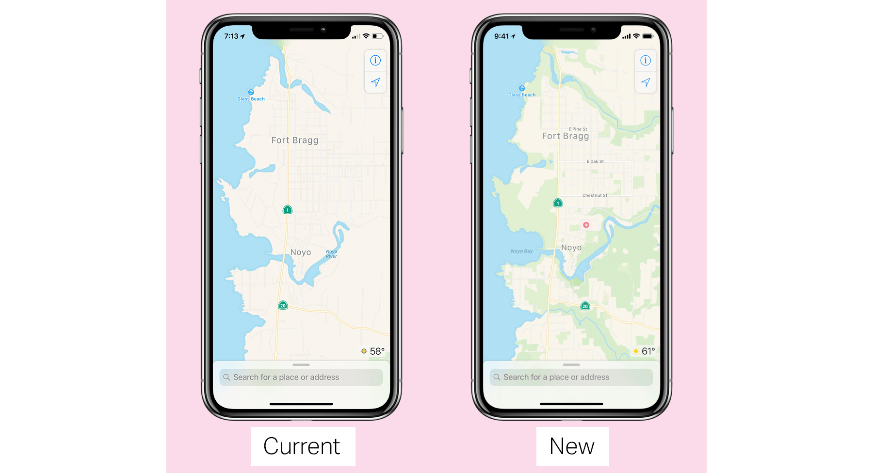
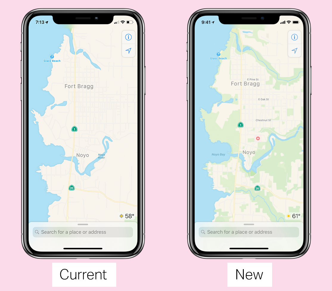
The result should be more accurate, frequently updated maps that do a better job reflecting points of interests, topography highlights, and other details that aren’t present in Apple Maps today. Judging from the screenshots in Panzarino’s article, the changes should be noticeable and useful, though the design of the app itself is not changing during the rollout of the new data.

→ Source: techcrunch.com

30 Jun 04:17

Shaw appoints former BC premier Christy Clark to its board

by Rose Behar

Freedom Mobile parent company Shaw has appointed former British Columbia premier Christy Clark to its board.

Clark was premier from 2011 to 2017, making her the longest serving woman premier in Canadian history. Previous to this, she served as a Liberal MLA for nine years, four of which she served in cabinet.

In its press release, the company made it clear it hoped Clark’s experience would help the company in its British Columbia market, while also generally assisting in decision-making through her business and political acumen.

“We are very honoured to have Christy join us as a Board member,” Shaw’s executive chair, J.R. Shaw, in a linked press statement.

“She brings to our Board a breadth and depth of relationships across Canada, both from politics and business, particularly in British Columbia, including in our largest single market, the greater Vancouver area.”

Clark stated: “I look forward to joining and making contributions to the Board as Shaw continues on its journey as a leading connectivity provider of broadband, video, voice and wireless services in Canada. I welcome the opportunity to support the company in growing its presence in British Columbia and its other key markets.”

Shaw announced its third-quarter 2018 financial earnings yesterday, revealing that Freedom Mobile added 54,000 net postpaid subscribers over the quarter. It also announced a new retail partnership for Freedom with Walmart Canada.

Image credit: Flickr – Tom

The post Shaw appoints former BC premier Christy Clark to its board appeared first on MobileSyrup.

30 Jun 04:17

Microsoft’s Surface Connect to USB-C adapter now available in Canada

by Jonathan Lamont
Microsoft Surface Connect to USB-C dongle

The USB Type C adapter Microsoft hinted at last year is now available in Canada today.

The adapter uses the Surface Connect port to connect USB-C devices. As dongles go, this one is quite large. It’s big and boxy and overall looks rather unruly, measuring in at 8.2cm long by 4cm wide by 2 m tall.

When you add in the Surface Connect cable, the length jumps to 28.4 cm — talk about ‘big dongle energy.’

It connects to the proprietary Surface Connect port on current model Surface Pro and Surface Laptop. It’s only compatible with these systems (Pro models 1796 and 1807 and Laptop model 1769).

The adapter offers a single USB-C port, which can be used to charge the computer. However, since there’s only one port you can’t charge the computer and also use a USB-C peripheral. Charging requires an adapter that outputs 27 watts or more with minimum 12 volts.

If all you’re looking to do is connect Type C peripherals, you’re probably better off with a Type C to Type adapter. Not only are those adapters less expensive, you’re also able to charge your computer at the same time.

The only real benefit to the Microsoft adapter is that it makes your USB-C peripherals magnetic. However, that’s a fairly small upside for a dongle this massive.

If having the biggest dongle on the block is your thing, the cable is available on the Microsoft store for $99.99.

Source: Microsoft

The post Microsoft’s Surface Connect to USB-C adapter now available in Canada appeared first on MobileSyrup.

30 Jun 04:17

Computer Science to the Second Degree

by Eugene Wallingford

Some thoughts on studying computer science from Gian-Carlo Rota:

A large fraction of MIT undergraduates major in computer science or at least acquire extensive computer skills that are applicable in other fields. In their second year, they catch on to the fact that their required courses in computer science do not provide the whole story. Not because of deficiencies in the syllabus; quite the opposite. The undergraduate curriculum in computer science at MIT is probably the most progressive and advanced such curriculum anywhere. Rather, the students learn that side by side with required courses there is another, hidden curriculum consisting of new ideas just coming into use, new techniques and that spread like wildfire, opening up unsuspected applications that will eventually be adopted into the official curriculum.

Keeping up with this hidden curriculum is what will enable a computer scientist to stay ahead in the field. Those who do not become computer scientists to the second degree risk turning into programmers who will only implement the ideas of others.

MIT is, of course, an exceptional school, but I think Rota's comments apply to computer science at most schools. So much learning of CS happens in the spaces between courses: in the lab, in the student lounge, at meetings of student clubs, at part-time jobs, .... That can sometimes be a challenge for students who don't have much curiosity, or develop one as they are exposed to new topics.

As profs, we encourage students to be aware of all that is going on in computer science beyond the classroom and to take part in the ambient curriculum to the extent they are able. Students who become computer scientists only to the first degree can certainly find good jobs and professional success, but there are more opportunities open at the second degree. CS can also be a lot more fun there.

30 Jun 04:15

Some More Very Satisfying Graphs

by chuttenc

I guess I just really like graphs that step downwards:

Screenshot_2018-06-27 Telemetry Budget Forecasting

Earlier this week :mreid noticed that our Nightly population suddenly started sending us, on average, 150 fewer kilobytes (uncompressed) of data per ping. And they started doing this in the middle of the previous week.

Step 1 was to panic that we were missing information. However, no one had complained yet and we can usually count on things that break to break loudly, so we cautiously-optimistically put our panic away.

Step 2 was to see if the number of pings changed. It could be we were being flooded with twice as many pings at half the size, for the same volume. This was not the case:

Screenshot_2018-06-27 Telemetry Budget Forecasting(2)

Step 3 was to do some code archaeology to try and determine the “culprit” change that was checked into Firefox and resulted in us sending so much less data. We quickly hit upon the removal of BrowserUITelemetry and that was that.

…except… when I went to thank :Standard8 for removing BrowserUITelemetry and saving us and our users so much bandwidth, he was confused. To the best of his knowledge, BrowserUITelemetry was already not being sent. And then I remembered that, indeed, back in March :janerik had been responsible for stopping many things like BrowserUITelemetry from being sent (since they were unmaintained and unused).

So I fired up an analysis notebook and started poking to see if I could find out what parts of the payload had suddenly decreased in size. Eventually, I generated a plot that showed quite clearly that it was the keyedHistograms section that had decreased so radically.

Screenshot_2018-06-27 main_ping_size - Databricks

Around the same time :janerik found the culprit in the list of changes that went into the build: we are no longer sending a couple of incredibly-verbose keyed histograms because their information is now much more readily available in profiles.

The power of cleaning up old code: removing 150kb from the average “main” ping sent multiple times per day by each and every Firefox Nightly user.

Very satisfying.

:chutten

30 Jun 04:15

Leaked Microsoft email confirms existence of foldable display ‘Andromeda’ Surface tablet

by Igor Bonifacic
Surface Book 2

It looks like Andromeda, Microsoft’s fabled foldable display Surface tablet, is no longer the stuff of merely patents and rumours.

In the email obtained by The Verge, Microsoft confirms the existence of the tablet and likens it to the original Surface, a device with the potential to disrupt the computing industry.

“It’s a new pocketable Surface device form factor that brings together innovative new hardware and software experience to create a truly personal and versatile computing experience,” writes the company when describing the device.

Engineering samples of the device reportedly look similar — if not identical — to renders (seen below) created by designer David Breyer. The device allegedly places a strong emphasis on stylus input and digital inking apps, with a wraparound foldable display that hides its hinge. In addition, Microsoft has reportedly experimented with ARM-based processors. The Verge, however, says it’s unclear if the company will to call on Intel or Qualcomm to supply CPUs for the final version of the tablet.

The Verge goes on to note its sources caution that Microsoft could cancel the project; this isn’t the first time the company has explored this concept.

In 2015, Panos Panay, the head of the company’s Surface division, confirmed the existence of Surface Mini, a 7-inch tablet device Microsoft never shipped. Panay likened the device to a “Moleskin” — which is likely an apt comparison for Andromeda, as well. Going even further back, Microsoft broke hearts in the last 2000s when it canned its secretive ‘Courier’ project. 

Should the company continue its present course, it reportedly plans to release Andromeda sometime this year, with similar devices from its OEM partners to “follow afterwards.”

Source: The Verge

The post Leaked Microsoft email confirms existence of foldable display ‘Andromeda’ Surface tablet appeared first on MobileSyrup.

30 Jun 04:15

Apple completely overhauling Maps using its own data

by Bradly Shankar
Apple Maps

Apple is rebuilding Maps from the ground up using its of mapping data.

In an exclusive behind-the-scenes look given to TechCrunch, the Cupertino computing giant confirmed that it will be doing away with all third-party mapping data, which has provided the basis of the Maps application since the feature launched in 2012.

Going forward, Apple will rely on data that it has gathered from sensor-equipped vans over the past several years. Apple will also incorporate anonymized bits of travel data obtained by iPhone users opening the Maps app to get updated road and traffic information.

While Apple Maps has been improved over time, the service has a rocky history, especially when compared to rival Google Maps. Originally, Apple Maps featured a rather convoluted display and incorrectly listed places, such as mistaking a grocery store for a hospital. Apple Maps also suffered from a lack of support for public transportation users, in addition to numerous bugs. Apple CEO Tim Cook later had to issue a public apology in response to the widespread criticism of Apple Maps.

Now, however, Apple says it’s taken significant steps over the past four years to improve its Maps service. “Since we introduced this six years ago — we won’t rehash all the issues we’ve had when we introduced it — we’ve done a huge investment in getting the map up to par,” Apple senior vice president Eddy Cue told TechCrunch in an interview. 

Apple Maps

“When we launched, a lot of it was all about directions and getting to a certain place. Finding the place and getting directions to that place. We’ve done a huge investment of making millions of changes, adding millions of locations, updating the map and changing the map more frequently. All of those things over the past six years.”

Altogether, Apple says thousands of employees — and hundreds of editors — have worked towards rebuilding Maps. The company also used computer vision and machine learning tools to help solve issues along the way, particularly when it comes to Maps’ design. Computer vision, as well as satellite imagery, has helped Apple make elements like water, sporting areas and vegetation appear more prominent and fleshed out. This tech also led to swimming pools being added to Maps for the first time.

Apple says the new iteration of Maps will initially only be available to preview in the iOS 12 beta next week for users in San Francisco and the Bay Area. Timing for a wider rollout was not confirmed, although Apple says the new Maps will become available to all iOS users eventually.

Source: TechCrunch

The post Apple completely overhauling Maps using its own data appeared first on MobileSyrup.

30 Jun 04:14

Hacking the ISTE18 Smart Badge

files/images/beacon2.png

Doug Levin, K-12 Cybersecurity Resource Center, Jul 17, 2018


At ISTE this year participants were given 'smart badges' - these tracked your movements and after the conference will provide participants with a report "listing of all the sessions you attended and links to any digital resources the session offered." More importantly, ISTE itself was provided "with information on session attendance and traffic flow in the expo hall and other open spaces, including playgrounds and poster sessions." Well, "ISTE calls this 'personalized learning,'" writes Audrey Watters. "I call it surveillance pedagogy and an act of violence against women just waiting to happen." Doug Levin took one apart and from the data inside found a user manual for the surveillance tags. In a follow-up post Levin serached for tag readers and found not only them but also surveillance cameras placed unobtrusively next to them. "I’ve made sure to keep my references to the ISTE ‘smart badge’ in quotes," writes Levin. "It is not smart. It is a Bluetooth location tracker – commonly used to locate lost cats, keys, and luggage – branded with words that connote innovation and trendiness and hence make it socially acceptable to track people."

Web: [Direct Link] [This Post]
30 Jun 04:14

There are a lot of rote tasks a good AI interviewer could do for you

files/images/imagesa0.jpg

Nicholas Diakopoulos, Columbia Journalism Review, Jul 17, 2018


We're not that far from seeing this sort of technology applied in day-to-day interactions. It will be mainstream within 20 years, I'd say. Already the technology exists to do narrowly-bounded applications. Consider: "There are a variety of unexpected but routine events that get reported on every day in the news, such as fires, sports, and crimes where basic structured information about the event could be collected by such a system." I can imagine such a system performing routine tests, exams and screening interviews. And, eventually, a lot more.

Web: [Direct Link] [This Post]
30 Jun 04:14

‘Evidence’ and the EEF toolkit: Reliable science or a blunt set of tools?

files/images/Terry-Wrigley_cropped.jpg

Terry Wrigley, BERA Blog, Jul 17, 2018


This article looks at issues related to the idea of ‘Evidence-based teaching’. There are several specific problems, but the primary issue (in my mind) is this: "It would be foolish for educators to reject evidence out of hand, as if tradition or instinct were enough, but what now stands proxy for the breadth of evidence is statistical averaging. This abstraction neglects practitioners’ accumulated experience, students’ needs and wishes, feedback, and an understanding of social context." It doesn't matter how people, on average, learn. It matters how I learn.

Web: [Direct Link] [This Post]
29 Jun 23:53

If You Write Every Day, You Will Write Crap

by Tris Hussey
Not all the time, but it will happen. And it’s okay. One of the best pieces of advice experienced writers give new writers (and remind each other) is to write every day. Every. Single. Day. One of the barriers to writing every single day is thinking that all that content, all those words, will to […]
29 Jun 23:53

New SD card specification enables faster speeds, up to 128TB storage

by Jonathan Lamont
amazon

The SD Association (SDA) released new specifications for SD cards at Mobile World Congress this week. The new specifications allow for more storage and faster read and write speeds.

The new specification utilizes two popular technologies to accomplish this. The first is PCI Express (PCIe), a high-speed connection port typically used in computers. Often, computer motherboards use PCIe, which allows for connection to integral system parts such as GPUs and some solid-state hard drives.

The second technology is Non-Volatile Memory Express (NVMe). NVMe is a standard for accessing non-volatile memory — memory that retains information after being power cycled. Additionally, the creators of NVMe designed it to be low-latency. It works in conjunction with PCIe.

Using PCIe and NVMe allowed the SDA to accomplish data transfer speeds of 985 megabytes per second. Dubbed SD Express, these new speeds will eventually come to all types of SD cards.

Furthermore, the new standard allows for a new SD Ultra Capacity (SDUC) card that is capable of up to 128TB of storage.

Manufacturers seldom reach maximum limitations like these. Previously, SDA promised a maximum capacity of 2TB. However SanDisk made the largest SD card to date, a prototype with 1TB of storage.

A 2TB SD card would have an astronomical price. SanDisk’s 1TB card originally cost $800 USD but has since dropped to around $300.

Since progress towards a 2TB card was slow, it will likely be a long time before we see any 128TB cards. However, the importance of having the capability to make SD cards that size cannot be understated.

With new data-heavy formats like 4K video and 360 degree video becoming more popular, massive storage options like this will be necessary.

Source: SD Association Via: The Verge

The post New SD card specification enables faster speeds, up to 128TB storage appeared first on MobileSyrup.

29 Jun 23:52

How to Protect Yourself when Cycling in the Summer Sun

by Average Joe Cyclist

How to Protect Yourself wCycling in the Summer Sun - Bikes on a Florida beachIn this post, Florida cyclist Karen Matthews shares valuable tips about how to protect yourself while cycling in the summer sun.

The post How to Protect Yourself when Cycling in the Summer Sun appeared first on Average Joe Cyclist.

29 Jun 23:52

Nicht einverstanden

by Udo Vetter
mkalus shared this story from law blog.

Aus dem Protokoll einer Hausdurchsuchung:

Herr N.. erklärte ständig und stets, dass er gegen alles sei und einen Anwalt nehmen will. Das Formular „Belehrung“ oder sonstige Papiere wollte er auf keinen Fall unterschreiben. Des Weiteren erklärte er, dass er mit der Auswertung und Durchsicht der beschlangnahmten Gegenstände nicht einverstanden sei.

Angaben zu Passwörtern/PIN/PUK/Emailadressen etc. … wollte er ebenfalls nicht machen.

Er erklärte sich mit einer Speichelprobe und einer ED-Behandlung nicht einverstanden. Gesprächsversuche blockte der Beschuldigte ab.

Oder wie der Strafverteidiger sagt: alles richtig gemacht.

29 Jun 14:48

China’s largest carmaker SAIC Motor launches its own AI lab

by Nicole Jao
Chinese multinational carmaker SAIC Motor (上汽集团) has launched its own AI lab, according to The Paper. The Shanghai-headquartered SAIC Motor is reportedly the first domestic automaker to establish an AI lab. The new lab will focus on research and development, as well as real-world AI solutions in three fundamental areas—cloud computing, big data and business applications—with […]
29 Jun 14:48

Hong Kong noodle shop to shut after 68 years – we have a final bowl of its famous egg noodles

by Bernice Chan
After 68 years, Hong Kong restaurant Wing Wah in Wan Chai, best known for its egg noodles made using a bamboo pole, will shut its doors at the end of August. The shop has already advertised its impending demise by covering its banner with Chinese characters saying “closing down”. As a result, when we recently visited the shop at 2pm on a weekday, there was still a large line outside the small restaurant. Hong Kong’s 7 best wonton noodle restaurants It took us almost 15 minutes...
29 Jun 14:48

What An Expensive SF Restaurant That Can't Afford Waiters Tells Us About the Future of Higher Ed

files/images/superJumbo.jpg

Joshua Kim, Inside Higher Ed, Jul 17, 2018


This is a case of a writer wanting to have it both ways. On the one hand, "Jobs that were once done by 2 people are now done by 1." On the other hand, "Almost everything that happens at a university that is of any value is done by a person." I think that what we'll find is that as automation takes over the quality of a university education doesn't decline as much as you think it would. Sure, automation is not as good as it could be. But like self-driving cars, we might find that the robots do a lot of cognitive tasks better than the humans. Photo: New York Times in a story about the restaurant.

Web: [Direct Link] [This Post]
29 Jun 14:47

Vancouver Civic Election Candidates on the Left — Getting Clearer

by Ken Ohrn
mkalus shared this story from Price Tags.

The Green Party of Vancouver, OneCity and COPE have announced candidates for the October 20, 2018 civic election in Vancouver. Vision Vancouver‘s list will be known on July 8.

Apparently, the Vancouver District Labour Council’s negotiated candidate quotas are still being negotiated, or something. What may result is a VDLC candidate endorsement list that is shorter than this list. Or something.

(*) denotes incumbent.

Mayor

  • None

City Council

  • Greens: Adriane Carr (*), Pete Fry, Michael Wiebe, David Wong
  • OneCity: Christine Boyle, Brandon Yan
  • COPE: Jean Swanson, Anne Roberts, Derrick O’Keefe

Park Board

  • Greens: Stuart Mackinnon (*), Camil Dumont, Dave Demers
  • COPE: John Irwin, Gwen Giesbrecht

School Board

  • Greens: Janet Fraser (*), Estrellita Gonzalez (*), Lois Chan-Pedley, Nicholas Chernen
  • OneCity: Carrie Bercic (*), Erica Jaff, Jennifer Reddy
  • COPE: Barb Parrott, Diana Day

Notable:

  • Greens’ Wiebe stepping up from Park Board
  • Greens’ Wong (housing critic) moving over from provincial BC Greens
29 Jun 14:47

It's a 'sad exercise' blaming past politicians for money laundering failures, says B.C. Liberal leader

mkalus shared this story :
"Remember, we are dealing with crooks here and they are slippery and evasive." Well if someone would know that, it's the BC Liberals.

Money laundering in casinos across the Lower Mainland reached a peak in 2015, according to a report from former RCMP deputy commissioner Peter German.

After releasing the report Wednesday, Attorney General David Eby put the blame on the previous B.C. Liberal government — saying it failed to address the problem for years despite warning signs.

B.C. Liberal leader Andrew Wilkinson sat down with Gloria Macarenko, the host of CBC's On The Coast, to talk about what the Liberal government did and could have done better.

There's a chapter of the report that lays out a timeline of money laundering called, A Decade of Dirty Money.

The B.C. Liberals were in government for that decade. Why wasn't more done to address the problem?

I wasn't directly involved during that time but my understanding is that there were efforts that did not succeed.

There was a recognition in 2011 by employees in the lottery business and the casino business that there was money laundering of significant interest.

The minister ordered an investigation and they embarked on a plan to address it. It was not successful because the perpetrators were canny enough to get around what they did.

There was then again another renewed effort in 2015 with the creation of the joint illegal gaming investigation team.

That proved to be much more effective and actually drove down the suspicious activity by about 60 per cent.

But look at what happened leading up to 2015 when it really reached its peak.

In 2004, the province and the RCMP created this special unit to investigate gaming crime.

Five years later in 2009, despite growing reports of suspicious transactions, the government ended that program. Why?

My understanding is that the conclusion of the law enforcement officials is that it wasn't an effective approach.

Remember, we are dealing with crooks here and they are slippery and evasive.

If the law enforcement officials come to the senior government officials and recommend that an approach is ineffective, obviously it's time to re-gig and do something differently.

Since the release of the report, we've heard from the public saying they want someone to be held accountable.

What do you say to the people who feel your party stood by while drug dealers easily laundered cash, fuelling the drug trade?

Peter German has done a good job of suggesting remedial efforts that can be taken in the future, but I'm not about to judge any police officer or civil servant and nor am I in a position to criticize any minister of the crown.

We need to focus on fixing this problem in the future, and laying blame on politics in the past is a rather sad exercise when the problem is to catch the perpetrators and not blame the politicians.

This interview aired on CBC's On The Coast on June 28 and has been edited for clarity and structure. To hear the full interview, click on the audio below.

Ad : Playback will start after this advertisement

Oops...

We're sorry, this content is not available in your location. If you believe you have received this message in error please contact us

Error 21
B.C. Liberal leader Andrew Wilkinson sat down with Gloria Macarenko, the host of CBC's On The Coast, to talk about what the Liberal government did and could have done better. 10:57

Read more from CBC British Columbia

29 Jun 14:24

Celebrate Canada Day with Netflix’s Canadian content

by Dean Daley
Netflix app on phone

Just in time for Canada Day, here’s a list of a number of Netflix movies and TV shows that were filmed in the great white north, made in Canada or at the very least, star Canadians.

If the list is too long, or if none of the content excites you, Netflix has also released a specific site listing all of its Canadian content in one convenient location.

Canadians in Starring Roles

    • Amanda Stephen from Quebec (Orange is the New Black)
    • Antoni Porowski from Montreal (Queer Eye)
    • Annie Murphy (Ottawa), Catherine O’Hara (Toronto), Dan Levy (Toronto) Eugene Levy (Hamilton)
    • Ellen Page from Halifax (Inception)
    • Ellen Wong hailing from Scarborough, Ontario (GLOW)
    • Finn Wolfhard from Vancouver (Stranger Things)
    • Jim Carrey from Newmarket (Liar Liar)
    • Michael Cera from Brampton (Superbad)
    • Mike Myers from Scarborough (Shrek)
    • Neve Campbell from Guelph (House of Cards)
    • Russell Peters from Toronto (Stand ups: Almost Famous & Notorious)
    • Ryan Reynolds (Deadpool, Just Friends, Definitely Maybe, The Change-UP, The Hitman’s Bodyguard, etc.)
    • Ryan Gosling (The Nice Guys, Drive and The Notebook)
    • Sandra Oh from Ottawa (Grey’s Anatomy)
    • Seth Rogen from Vancouver (Hilarity for Charity, 50/50)

Filmed Canada

  • Lost in Space (Vancouver)
  • Riverdale (Vancouver)
  • Suits (Toronto)
  • Travelers (Vancouver)
  • Coming Soon: The Chilling Adventures of Sabrina (Vancouver)
  • Coming Soon: The Umbrella Academy (Toronto)

Canadian Content

  • Alias Grace
  • Anne with an E
  • Baroness Von Sketch Show – Seasons 1 & 2
  • Degrassi: Next Class – Seasons 1 to 3
  • Goon
  • Heartland – Seasons 1 to 10
  • Kim’s Convenience – Seasons 1 & 2
  • Mr.D – Seasons 1 to 7
  • Schitt’s Creek – Seasons 1 to 3
  • The F Word

The post Celebrate Canada Day with Netflix’s Canadian content appeared first on MobileSyrup.

29 Jun 14:24

OnePlus commits to new two-year software update policy

by Igor Bonifacic
The OnePlus 6 is 'Silk White'

OnePlus is committing to a Pixel-like software policy.

On Thursday, the company announced, via its community forums, an official “Software Maintenence Schedule”.

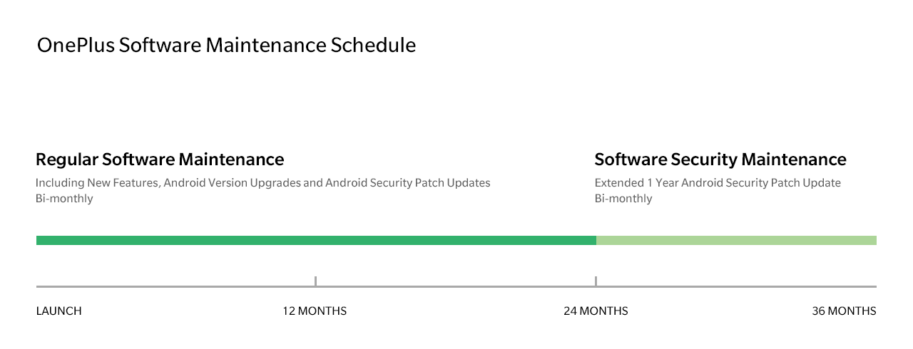
Per the schedule, seen below, OnePlus will provide its devices with two years of software updates. Included in that promise is major operating system upgrades like the upcoming move to Android P.

Moreover, the company says it will push out an additional year’s worth of security updates, released every two months, to its devices.

In short, OnePlus’ new update policy matches up almost exactly with Google’s, though its updates are likely to come out at a slightly slower clip compared to Mountain View.

OnePlus' new software maintenance schedule


According to OnePlus, the new policy is going into effect immediately, starting with the OnePlus 3, 3T, 5, 5T and 6. It will also apply to any devices the company releases in the future.

As a result of the new policy, OnePlus will issue its final major software update to the OnePlus 3 and 3T this November, with security updates coming to an end in November 2019.

While OnePlus has had one of the better track records when it comes updating its devices, this is a major step in the right direction for the company. It makes it a lot easier to recommend one of the company’s devices.

Source: OnePlus

The post OnePlus commits to new two-year software update policy appeared first on MobileSyrup.