Sugar cane burning is so dangerous that it is banned in India. The practice is also being phased out in Brazil and Thailand.Sugar cane burning will soon only be permitted in one of the top four sugar-producing countries - the United States.
When sugar cane farmers burn their fields the cane emits huge clouds of black smoke. This smoke contains fine particulate matter, or PM2.5, which is
NOAA has released an interactive map which uses historical temperature data to map the Average Date of Last Spring Freeze Across the United States.Using the map you can view the last day on average when there is a chance for freezing temperatures at thousands of locations across the whole country.NOAA's last spring freeze map uses temperature data from 1991-2020 captured from weather stations
Polish contributors have mapped over 2000 AEDs. Cristoffs proposed > normalising the access tags applied and is waiting for feedback.
On Saturday 26 February the first Latin American Notathon > was held to promote map note resolution in all Latin American countries.
Raphaelmirc reported > that UMBRAOSM > will hold a mapathon on Saturday 5 March. The city of Xexéu, in the state of Pernambuco (Brazil), will be mapped.
Mapping
Mateusz Konieczny has proposed stopping the use of opening_hours:covid19=*.
On the Tagging mailing list, Dian Ågesson suggested splitting the list into multiple lists.
kubahahaha suggested > distinguishing between different paid parking zones by using the colour tag.
The Data Working Group has blocked the Map Builder user account permanently. The profile claims to be a proxy account of Microsoft for anonymous contributions using the experimental Map Builder platform. See the block message for further details.
Trufi Association and Crowd2Map Tanzania held a webinar: Introduction to Mapping Public Transport.
Community
Users can now delete their OpenStreetMap accounts themselves without needing to contact the sysadmins (via GitHub).
BudgieInWA reflected on a social mapping meetup held in Claremont, Western Australia (we reported earlier), by a group of seven OSM enthusiasts. The diary entry describes and illustrates the planning and execution process, which may be useful to others planning similar events.
ealp recalled that 8 years ago, Valentine’s Day was celebrated in Mexico by having a meet-up to talk about OSM and HOT in Mexico City. The result was that OSM people found each other to initiate and advance the now intense and useful work in OSM through the creation of the Mexican Community.
We reported in December that Florian, Adrien and Donat had launched their YouTube channel ‘Tropicana’. So far two live nights have been broadcast. One about mapping toys shops for Christmas, and the other on mapping bakeries for galettes des Rois. They welcome you to join every first Wednesday of the month at 20:30 CET. Events are beginner-friendly, and the next will be on 2 March at Tropicamap. Tropicamap can also be followed on Twitter.
Local chapter news
Have a look at the 2022 OpenStreetMap US Board Election Results!
Events
State of the Map 2022 will take place in Florence, Italy from 19 to 21 August as a hybrid conference. The scientific committee is looking for members to be responsible for the academic track.
The State of the Map Working Group is calling for logo proposals for SotM 2022, to be held in Florence, Italy.
Ilya Zverev pointed out > , as a member of the organising team, that after two online events the next SotM from August 19–21, 2022 in Florence should on the one hand take place as a face-to-face event, but on the other hand should also make online participation possible.
Education
gnulinux.ch > has started its series on QGIS. Published so far are:
b-unicycling has created a uMap of vacant buildings in Kilkenny and written a blog entry about his reasons for it and the reactions she received.
[1] After a discussion > about redesigning the German OpenStreetMap.de website, miche101 created a showcase page, which includes a lot of tools and links around OpenStreetMap.
switch2OSM
Pedal Me, an e-cargo-bike company for student and freight transport in London, has used OSM data to argue for the superiority of cargo bikes over cars in cities.
Programming
The code powering the OpenStreetMap.org website has been updated to Rails 7.
Releases
StreetComplete users are going to have to do a manual app update starting with v41. The reason for this is a new feature: you’ll be able to measure widths and heights with your camera. This will require additional permission and as a result neither Google Play nor F-Droid will automatically update to this major version.
Did you know …
… Bruno Duyés’ OpenPianosMap? The goal of this project is to create an open source map of accessible pianos. Doudouosm said on Mastodon: ‘… with its companion MapContrib theme, it’s never been easier to add the ones you run across’.
… there is a calculator for distances and driving routes? In the bottom of the right sidebar on the website there are other localised versions of the calculator.
… the overview of specialised online maps that use OpenStreetMap as a data source?
OSM in the media
Guillaume Rischard checked the claim from Lydie Polfer (Mayor of Luxembourg City) that 87% of Luxembourg’s streets are speed limited to 30 km/h. In fact only 35%, by length, of Luxembourg’s streets have speed limits of 30 km/h or less, according to OpenStreetMap data.
Other “geo” things
Alastair Otter presented nine essential mapping tools for journalists.
Google has launched > its Detailed Street Maps feature in Brussels (Belgium), offering further details about pavements and other pedestrian-oriented features.
Upcoming Events
Where
What
Online
When
Country
Puerto López
Notathon en OpenStreetMap – resolvamos notas de Latinoamérica
2022-02-26
IJmuiden
OSM Nederland bijeenkomst (online)
✓
2022-02-26
Bremen
Bremer Mappertreffen (Online)
✓
2022-02-28
London
Missing Maps London Mapathon
2022-03-01
San Jose
South Bay Map Night
✓
2022-03-02
Landau an der Isar
Virtuelles Niederbayern-Treffen
✓
2022-03-01
Berlin
OSM-Verkehrswende #33 (Online)
✓
2022-03-01
Stuttgart
Stuttgarter Stammtisch (Online)
2022-03-01
Olomouc
březnový olomoucký mapathon
2022-03-03
Xexéu
Mapathona na Cidade Xexéu – PE -Brasil – Edifícios, Estradas, Pontos de Interesses e Área Verde
2022-03-05 – 2022-03-06
OSM Africa March Mapathon: Map Sierra Leone
2022-03-05
Bogotá Distrito Capital – Municipio
OpenDataDay – Mapeando el barrio Nicolás de Federmán de Bogotá, Colombia
2022-03-05
OSMF Engineering Working Group meeting
2022-03-07
Meatu
Map Tanzania to help protect girls from FGM for International Womens’ Day
✓
2022-03-08
Marburg
FOSSGIS 2022
2022-03-09 – 2022-03-12
Michigan
Michigan Meetup
✓
2022-03-10
München
Münchner OSM-Treffen
2022-03-10
Berlin
165. Berlin-Brandenburg OpenStreetMap Stammtisch
✓
2022-03-10
Lyon
EPN des Rancy : Technique de cartographie et d’édition
2022-03-12
149.Treffen des OSM-Stammtisches Bonn
2022-03-15
San Jose
South Bay Map Night
✓
2022-03-16
Lüneburg
Lüneburger Mappertreffen (online)
2022-03-15
London
Geomob London
2022-03-16
Großarl
4. Virtueller OpenStreetMap Stammtisch Österreich
2022-03-16
Note:
If you like to see your event here, please put it into the OSM calendar. Only data which is there, will appear in weeklyOSM.
AppleInsider looks at how online maps (Apple Maps, Google Maps), especially their traffic layer, inadvertently revealed Russian troop movements at the start of the Russian invasion of Ukraine.
The sheer volume of mapping data now available at our fingertips means it was possible for civilians half a world away to see when Russian forces began moving. Specifically, that data pinpointed a traffic jam starting on the Russian side of the border, actively moving into Ukraine in the first few minutes of the Russian and Ukraine conflict.
Just as with any cartography, this information required interpreting. Google Maps did not specifically say that it was troop movements, nor was its satellite imagery up to the minute. During the process of researching this story, we’ve confirmed that Apple Maps presented similar inbound troop movement information—but it wasn’t setting out to do that either.
What these services did, though, was register all of the smartphone users whose driving was slowed or halted by unusual traffic conditions. Wherever the majority of the data came from, it was possible to determine what was happening when coupled with known details of Russian troop locations.
Every year the Committee to Protect Journalists (CPJ) releases an annual report on the number of journalists imprisoned and killed by countries across the world. Nearly every year China tops the chart as the worst offender, most years killing and imprisoning more journalists than any other country in the world. You probably won't be surprised to hear that Putin's Russia also consistently
Kai Michael Poppe has extended his multi-purpose-bot to also inform the D-A-CH Telegram group when a new issue of weeklyOSM is published.
Kai invited other Telegram groups that are interested to make use of this service too, using a new bot.
We have created a spreadsheet in which we ask administrators to enter the Telegram group that they want to be served directly when a new weeklyOSM is published.
Mapping
Managing imagery alignment has always been a problem; bdhurkett found a solution for Burnie (Tasmania) as suburb polygons are well aligned with fences and other property boundaries. They outline how they are incrementally adjusting OSM objects to match these alignments more consistently.
SherbetS showed a setup for river mapping using a PlayStation controller and JOSM.
SK53 continued his examination of how natural=heath is used in Wales with a detailed example of a small hilltop heathland which was previously unmapped.
Voting is underway for the following proposals:
motorroad=yes > , to formalise a definition of motorroad for Japan, until Saturday 4 December.
ref:EU:bwid=*, to record the unique identifier of a bathing site, until Monday 6 December.
Community
Canadian cartographers discussed, on the forum, the relevance of special mapping for flood disasters and landslides in various areas of British Columbia.
The Local Chapters and Communities Working Group presented the ‘OpenStreetMap Welcome Tool’. The tool is designed to make it easy to welcome new mappers to your country or region.
OpenStreetMap Foundation
On the OSMF mailing list Heikki Vesanto suggested a ‘made with OSM logo’ along the lines of those of Natural Earth and QGIS. Note that this is subtly different from an OSM mark, an idea which was recently revived (as we reported earlier), in that it would be additional to, not a replacement for, existing attribution requirements.
Michal Migurski, candidate for the OSMF Board, asked on MetaFilter about ‘organisations that form in spite of their grassroots counterparts’, and asked how ‘new members’ could ‘circumvent a community organisation to form something larger and more organised’.
Events
Both State of the Map Africa and the HOT Summit occurred last weekend (20 and 22 November), a little too late for inclusion of highlights in this week’s weeklyOSM. One talk several people noted on Twitter, was by Alazar Tekle from AddisMap, one of the earliest OpenStreetMap startups anywhere in the world. No videos, at present, but you can view their, virtual, presentation at State of the Map 2010 on YouTube.
Education
Pascal Neis left a message on the changeset of a Chinese newcomer to ask why they deleted lots of data. Another user in the comments pointed out that this was OSM mapping homework assigned to students by an instructor at Central South University. Other mappers from China also showed their disappointment > with these homework changesets. Should teachers be responsible for such improper behaviour of students? How should we deal with the teacher’s assignment of editing in OSM as homework?
Videos of presentations by Heidelberg Institute for Geoinformation Technology (HeiGIT), given at the recent FOSS4G conference, are now available online. Subjects include: an OSM Confidence Index developed using the ohsome.org framework, and an introduction and update on MapSwipe .
OSM research
Alexander Zipf’s group has received funding to start a new project related to climate change actions – ‘GeCO – Generating high-resolution CO2 maps by Machine Learning-based geodata fusion and atmospheric transport modelling’.
Maps
Here are some selected OpenStreetMap-based maps from the penultimate week of the #30DayMapChallenge, which we have been following all month:
Day 17: Land: Steven Kay produced a rotating globe with only the largest islands visible.
Day 22: Boundaries: Arctic boundaries with a polar projection (Andrew Zolnai), and a tiny pene-enclave on the Norway-Sweden border (Steven Kay).
Software
The website Visionscarto announced > the launch of three tools built with OpenStreetMap and uMap to identify available agricultural lands and their uses by the association ‘Terre de liens’.
Hauke Stieler created a web application called OSM Open to find POIs that are open at a selected point in time. The data can also be filtered by tags and the source code is available on GitHub. He has chosen to hide the OpenStreetMap attribution by default.
Did you know …
… the existence of the xmas:feature key? While scarcely used (about 2000 items) and mainly in Germany, this ‘in use’ tag was introduced in 2009 and grows each year by a few hundred or so. Its use has been debated and a merging proposal with the temporary: namespace was made, but the proposal has been inactive since 2016.
[1] … the Open Indoor Viewer called ‘OpenLevelUp‘?
… there is a list of new keys recently created in OSM? Most of them involve typos or ignorance of established tagging principles. Comes with direct links to correct them.
… OSM Streak, the gamified web application that encourages you to do small tasks in OpenStreetMap every day? There is also a Telegram account named @osm_streak_bot, which you can configure to remind you of your daily task.
OSM in the media
The government of France has unveiled > its action plan for open source software and digital commons which, as its name suggests, aims to strengthen the use of open source and encourage the opening up of public data. A specific objective is to reference open source software and digital commons such as OpenStreetMap, a free and collaborative digital tool from which other tools such as transport.data.gouv.fr > are derived.
Other “geo” things
Archival geodata are now available > as WMS layers from the Polish national geoportal.
The general secretariat of the German Red Cross (GRC), based in Berlin, is looking for a ‘Manager Geoinformatics’. The position is responsible for the implementation of the project ‘Development of geoinformatics for the international humanitarian aid activities of the GRC – Strengthening the cooperation with the Heidelberg Institute for Geoinformation Technology’. The person chosen will also help develop programmes and basic approaches for the use and support of OpenStreetMap.
Reibert wrote > about the official state register [uk] > of permits to harvest timber in Ukraine.
SkyNews reported that Mapbox’s route to a stock market listing, through a Softbank SPAC (Special Purpose Acquisition Company), has run out of steam.
Upcoming Events
Where
What
Online
When
Country
UCB Brasil + CicloMapa: curso de mapeamento
2021-11-16 – 2021-11-26
UN Map Marathon
2021-11-22 – 2021-11-26
[Online] OpenStreetMap Foundation board of Directors – public videomeeting
2021-11-26
Brno
November Brno Missing Maps mapathon at Department of Geography
2021-11-26
HOTOSM Training Webinar Series: Beginner JOSM
2021-11-27
Amsterdam
OSM Nederland maandelijkse bijeenkomst (online)
✓
2021-11-27
長岡京市
京都!街歩き!マッピングパーティ:第27回 元伊勢三社
2021-11-27
Bogotá Distrito Capital – Departamento
Resolvamos notas de Colombia creadas en OpenStreetMap
Today is The Map Room’s 18th anniversary. When I started this blog back in March 2003, it was as an exercise in self-education: I liked maps a lot, but knew very little about them, and thought that the blogging process would enable me to learn things and share what I learned with my readers. The idea that I’m some kind of map expert is just silly: I have no professional credentials whatsoever, not in cartography, not in geospatial, not even in illustration. (I haven’t even taken geography since high school.)
But that’s not to say that I haven’t picked up some knowledge: I’ve turned my longstanding interest in fantasy maps into a few published articles (with more still in the works or in press), so I will concede the point on that front. But in general what I do have is exposure. Over the past 18 years I have seen just about everything to do with maps, and so I know a little bit about just about everything. Not enough to be employed at any map-related job, but 18 years of paying attention, of synthesizing everything I’ve seen and read, has afforded me some perspective.
Enough to call out obvious horseshit when I see it.
Also, because I’m not a cartographer, because I don’t have that background or training, because my expertise is a hundred miles wide but a millimetre thick, I’d be extraordinarily reluctant to tell cartographers that what they’ve been doing for the past few centuries has been completely wrong, and that I’ve come up with something better that no one has ever thought of before—only for the something better to be utterly old and familiar to those who know what they’re doing.
I don’t have that kind of chutzpah.
Arno Peters did, though. In 1974 the German historian presented the Peters World Map (a retread of an 1855 equal-area projection by James Gall) as the antidote to a Mercator projection that emphasized temperate regions over the tropics: the Global West over the Global South. In doing so Peters was fighting a battle that, Mark Monmonier has argued, was mostly already won by the 1970s. The Mercator had long been seen as unsuitable for world maps, with wall maps and atlases already having moved on to the Goode’s homolosine, Mollweide and Van der Grinten projections, among others, by the mid-20th century.
Even so, cartographers generally hated the Peters map because it was foundationally ignorant: Peters was dabbling in map projections without understanding their history. He and his adherents invented a false dichotomy—Peters vs. Mercator—and marketed the projection to credulous audiences (e.g. Boston schools as recently as four years ago) as a solution to a problem that in truth was neither unsolved nor really a problem.
Guess what? It’s happening again.
In 2007 a pair of physicists, David Goldberg and J. Richard Gott, published an article in Cartographica in which they proposed a way of measuring and scoring map projections by six kinds of distortion—area, shape, distance, boundary cuts, flexion and skewness (the latter referring to bending and lopsidedness). According to their system, the Winkel Tripel projection, currently in use at National Geographic, had the best score: 4.563. (The lower the score, the better: a globe’s score is zero. The Mercator’s score is 8.296.)
Last month, in an unpublished paper uploaded to Arxiv, Goldberg and Gott, along with Robert Vanderbei, tried to come up with something better than the Winkel Tripel, and arrived at a pair of azimuthal equidistant projections centred on each pole and extending to the equator; the twist, as they see it, is to make the map double sided.
North Pole on the front; South Pole on the back (Gott, Vanderbei and Goldberg).
“To the best of their knowledge,” says the piece from Princeton’s communications office, “no one has ever made double-sided maps for accuracy like this before. A 1993 compendium of nearly 200 map projections dating back 2,000 years did not include any, nor did they find any similar patents.”
Except that maps showing the world in two hemispheres date back at least as far as the 16th century (there’s one on my wall) and polar azimuthal projections aren’t exactly new either: they’re splitting hairs awfully fine to make that claim. Regardless, their double-sided map gets a score of 0.881 on their Goldberg-Gott scale.
Matthew Edney was not impressed; as you might expect, he did not hold back. “I am utterly and thoroughly gobsmacked,” he wrote last month in a piece that marvels at the claims made in the PR piece.
Underpinning all this sheer stupidity and naivety are some serious points about what these astrophysicists understand maps to be. It is not that they are ignorant of the mathematical principles; two have published a paper in a map journal on their measures of map distortion (Goldberg and Gott 2007; also Gott, Mugnolo, and Colley 2007). But it seems that from their highly mathematicized perch they have realized that world maps are actually useful for imaging and visualizing the world. But they want the maps to also be as accurate as possible, according to their own idiosyncratic criteria. […]
Ultimately, once one has stripped away the immense amount of PR guff and hyperbole, there’s little to recommend this as a “new” and “different”—other than the proposal to paste the two halves together. And I’m pretty sure I’ve seen an eighteenth- or nineteenth-century hand-held fan with hemispheres drawn on either side …
They have really only reinvented the wheel.
In a separate piece Edney has some questions about the parameters used in Goldberg and Gott’s scoring system, a couple of which he finds dubious, along with the way they’re tallied up.
Someone coming in from outside the field to “solve” the map projection problem sounds an awful lot like Arno Peters all over again—especially since their little paper has picked up a certain amount of media attention—see coverage from The Verge and the New York Times—that trumpets the possibility that this projection “fixes” flat maps, or the distorted view of the world that we get from flat maps.
Hoo boy. That’s a hell of a claim—one we’ve seen before. Except that Peters purported to solve map projections’ problem of representation. These professors sound like they’re going after the impossible Holy Grail of map projections: to find the most perfect, least distorted map, the One True Map that will leave all others in its dust, the One Projection that can be used all the time and in every circumstance. (The number of questions I’ve seen on Quora, for example, that insist upon this impossibility—that there is such a thing as an “accurate” map projection—is striking.)
Only they’ve defined “most accurate” as “fewest distortions according to our own criteria.” In doing so they’ve reduced map projections to a simple math problem that ignores centuries of map history, to say nothing of real-world uses. In other words: a spherical cow—a model reduced to the point of oversimplification so that it works.
Because you’d be hard pressed to find an actual use case for their double-sided map of the world. As Edney points out, only half of the world is viewable at once: “The point of world maps is to show the whole earth, but one can’t see the entire earth, so the most accurate world map doesn’t show the whole earth” (which somehow doesn’t incur a penalty in their schema). And heaven forbid you should want your world map to show all of Africa, or South America, or Indonesia, at the same time.
Thing is—and regular readers will know I’m preaching to the choir here—there is no such thing as the perfect map projection. Only the right projection for the job at hand. The antidote to a given map projection’s distortion is a different map projection whose distortion is less problematic for what you’re trying to map. Some distortions you can live with in order to preserve fidelity elsewhere. I’m fond of the Equal Earth projection, but I wouldn’t use it if I wanted to emphasize the polar regions.
It’s a practical choice, in other words, one that I’ve come to understand, from my 18 years of paying attention to this, as a basic challenge of map design. One that you can’t simply come in and solve with math. It’s tempting to see this as a variant of the Dunning-Kruger effect—or at least the popular understanding of it: an inability to recognize your lack of ability—that in my experience seems to afflict an awful lot of physicists and engineers. Reduce the problem until it’s solvable, then solve it.
First, assume a spherical cow.
Interesting as an exercise, but not particularly useful.
Every 17 years cicada nymphs in the eastern United States emerge en masse from underground. For a few weeks the adult cicadas fly around, make a lot of noise, have sex and lay eggs. Then they die - not to be seen again for another 17 years. Brood X cicadas have this month been spotted in Washington, D.C., and in surrounding areas such as Virginia and Maryland. They have also emerged in
The COVID-19 pandemic. Elections around the world. Fact-checkers worldwide have had a busy year. More than 50,000 new fact checks surfaced on Google Search over the past year, with all fact checks receiving more than 2.4 billion impressions in Search in that timeframe.
A growing body of external research suggests that fact checks can help counter falsehoods. In a new report supported by the Google News Initiative published today, researchers Ethan Porter, Thomas Wood and Yamil Velez found that corrections in the form of fact checks reduce the effects of misinformation on beliefs about the COVID-19 vaccine.
Fact-checking isn’t just for the professionals, however. Every day, people seek evidence to confirm or refute a piece of information they’re uncertain about. Over the past 12 months, Google searches for “is it true that...” were higher than “how to make bread,” and that’s saying something given last year’s sourdough craze.
We're committed to supporting all users as they look for reliable information online, and sharing our insights with other organizations to strengthen fact checking.
With that in mind, and ahead of International Fact Checking Day on April 2, here are five simple tips to help you ask the right questions so you can better spot misinformation online.
1. Find out more about the source.
Have you ever stumbled across a surprising story from a website you’ve never heard of? First, see whether the source itself checks out. After searching for the website, you can tap on its menu icon to learn more about the result (in English in the United States only, for now).
In this simulated example, you can see how to learn more about a result you find online. In this case you can see our imagined Mars Robot News site doesn’t have accurate information about the planet.
If you click on the result, you can see how the site describes itself on its “About” page, but you may want to get a second opinion. You can do that by asking Google to remove results from the domain itself. The query would look something like this: about youtube -site:youtube.com. Want to refine your search even further? Find more tips on our support page.
2. Check if an image is being used in the right context.
A picture is worth 1000 words, as the old adage goes. But a picture can also be taken out of context or edited to mislead. You can search with an image by right clicking on a photo and selecting “Search Google for Image.” You can do the same on mobile by touching and holding the image. This will look for the picture to check if it has appeared online before, and in what context, so you can see if it has been altered from its original meaning.
See how an image is being used in context online. You can search with an image by right clicking on a photo and selecting “Search Google for Image.” This is a simulated example to illustrate how this product works and not the actual experience.
3. Look for news coverage.
What’s better than one source? Several! See how (and whether) different news outlets have reported on the same event so that you can get the full picture. Switch to news mode or search for a topic in news.google.com. Make sure to click through to “Full Coverage” if the option is available.
Looking for news on if Earth was visited by aliens? In this simulated example you can see how you can click to find Full Coverage on a topic, and see what other news organizations are covering it. This GIF is a simulated example and is not the full experience of how the product works.
4. Consult the fact-checkers.
Fact-checkers may have addressed that random story your relative sent you in the group chat – or a similar one that will point you in the right direction to find out what really happened. Try searching for the topic in the Fact Check Explorer, which collects more than 100,000 fact checks from reputable publishers around the world.
In this simulated example see how you can use Fact Check Explorer to find out if an online claim has been fact checked. This is a demonstration of how the product works and not the full experience.
5. Use Google Maps, Earth or Street View to verify the location.
False stories about events happening in far-off places can spread due to our lack of familiarity with their location. If you want to get a sense of whether a photo is actually from the place it claims to be from, try checking Google Earth or look at the Street View of a location on Google Maps.
Say your friend sends you a story about Bigfoot strolling by the Eiffel Tower in Paris, France. Searching for the Eiffel Tower on Street View will at the very least confirm that the tower doesn’t have a big red cowboy hat at the top (like it does in Paris, Texas). If that part doesn’t check out, the rest of the story might be fishy, too.
In this simulated example, you can see how you can find the differences between the real Eiffel Tower in Paris, France and the one in Paris, Texas. This is just a demonstration and not the full product experience.
We’re committed to helping people spot misinformation online and supporting the fact-checking ecosystem.
Most recently, we provided $3 million to journalistic efforts fact-checking misinformation about the COVID-19 immunization process, with a concentration on projects that aim to reach audiences underserved by fact-checking. We also launched a GNI University Verification Challenge across Asia to help the verification skills among journalism students. In addition, Google.org helped the nonprofit Full Fact through grant funding and seven full-time pro-bono engineering fellows to boost the number of claims they could detect.
For more tips and best practices, check out the resources put together by the International Fact-Checking Network at factcheckingday.com. And if you’re a journalist, check out the GNI Training Center.
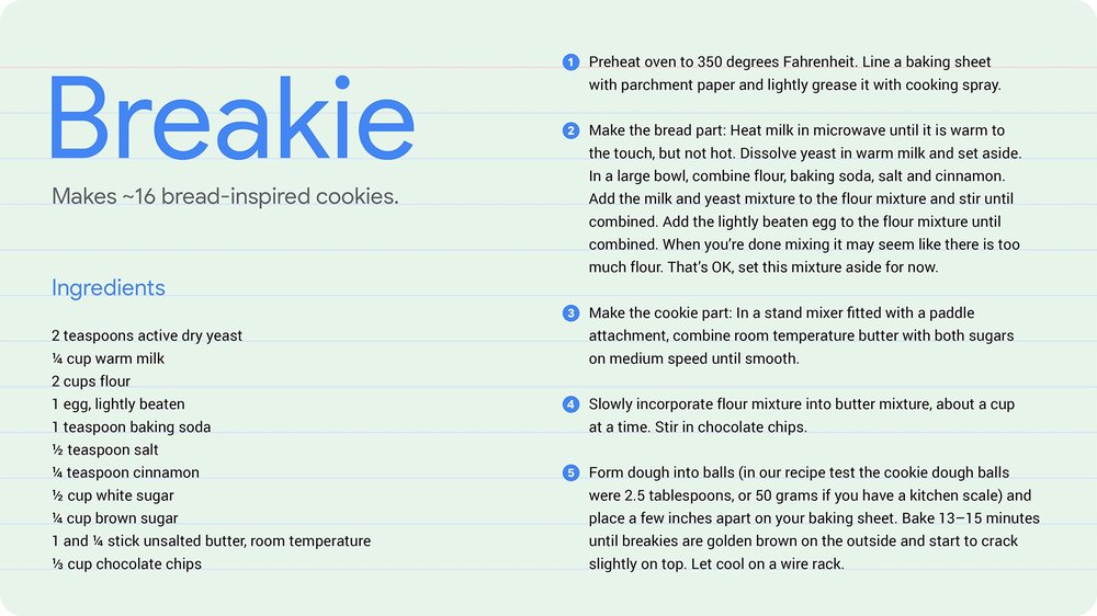
Baking is something that I like to do to relax; spending leisurely evenings creating something beautiful with as much care and precision as possible. Baking with AI—blending my day job as a machine learning engineer with one of my favorite hobbies—makes this experience even better. Plus, the serendipitous nature of building the model, arriving at a new and unique recipe and then testing it in the kitchen, is incredibly fun.
So, when legendary confectioner Mars Wrigley approached us for a Maltesers + AI kitchen collaboration, I jumped at the chance. Maltesers are a popular British candy made by Mars. They have an airy malted milk center with a delicious chocolate coating.
Like so many others, I jumped on the baking bandwagon during the pandemic and baked up a storm throughout 2020. According to Google Search Trends, in 2021 people searched for “baking” 44% more when compared to the same time last year. You might even say the trend continues to rise.
But what were people actually searching for in the UK and could it inspire a new recipe for Mars Wrigley? I discovered that one of the top searched questions recently regarding “sweet and salty” was “Is Marmite sweet or savory?” Knowing how popular Marmite is in the UK, I decided it must be included in my newest creation. My goal was to use machine learning to create the base recipe for this dessert, and then find tasty ways to incorporate both Maltesers and Marmite.
I created a new machine learning model and fed it hundreds of existing recipes for cakes, cookies, scones and traybakes. After the model learned the combinations of ingredients that make up these baked goods, I had it generate recipes for each of them. Unlike most ML models, this one required testing in the kitchen to make sure the ingredient combinations generated by the model produced baked goods you’d actually want to eat. Picture me and my laptop in a cloud of flour, tasting batter and frosting, and eating way too many Maltesers along the way.
I’m skipping a lot of the ML magic! For a technical deep dive on how the AI works, see this blog post. For baking enthusiasts, these pictures share a little more of the process. Midway through baking the cake, I added three surprise Maltesers in the middle, and a cookie layer on top (which becomes the bottom when you flip these out). Yum!
Where’s the Marmite, I hear you say!? I whipped up a Marmite-infused buttercream topping. It’s delicious! Don’t believe me? See the recipe below, give it a whirl and let me know what you think. Share photos on Twitter or Instagram using the hashtag #BakeAgainstTheMachine, and head over to BakeAgainsttheMachine.co.uk to learn more about this project from Mars and find more special Maltesers recipes. I can’t wait to see your creations!
In January, the Threat Analysis Group documented a hacking campaign, which we were able to attribute to a North Korean government-backed entity, targeting security researchers. On March 17th, the same actors behind those attacks set up a new website with associated social media profiles for a fake company called “SecuriElite.”
The new website claims the company is an offensive security company located in Turkey that offers pentests, software security assessments and exploits. Like previous websites we’ve seen set up by this actor, this website has a link to their PGP public key at the bottom of the page. In January, targeted researchers reported that the PGP key hosted on the attacker’s blog acted as the lure to visit the site where a browser exploit was waiting to be triggered.
SecuriElite website
The attacker’s latest batch of social media profiles continue the trend of posing as fellow security researchers interested in exploitation and offensive security. On LinkedIn, we identified two accounts impersonating recruiters for antivirus and security companies. We have reported all identified social media profiles to the platforms to allow them to take appropriate action.
Actor controlled LinkedIn profiles
Actor controlled Twitter profiles
Tweet from SecuriElite announcing new company
At this time, we have not observed the new attacker website serve malicious content, but we have added it to Google Safebrowsing as a precaution.
Following our January blog post, security researchers successfully identified these actors using an Internet Explorer 0-day. Based on their activity, we continue to believe that these actors are dangerous, and likely have more 0-days. We encourage anyone who discovers a Chrome vulnerability to report that activity through the Chrome Vulnerabilities Rewards Program submission process.
Editor’s note: This week, we were deeply saddened by the shootings in Atlanta that left eight people dead, including six women of Asian descent. Google is a proud supporter of the Asian American and Pacific Islander community, and we stand with them in the fight against hatred. In this post, Eva Tsai, Director, Marketing Analytics and Operations, shares her personal experiences and reflections on racism and discrimination as an Asian American.
When a stranger asks you where you’re from, the question is often not as simple as it seems. As an Asian American, when someone asks me that question, I run through a quick mental calculation to figure out what they really mean.
Some people just use it as an innocuous way to start a conversation. Others, however, have an underlying assumption: To them, someone like me can never truly be an American. They’re really asking, “Which foreign country are you really from?”
Years ago, in the Houston airport, a white man in a suit decided to single me out. I was the only Asian person in sight. “Where are you from?” he shouted across the packed airport train car. I had just finished a grueling week of business travel and meetings, and I just wanted to be left alone. Despite my silence, the man continued asking the question, with increasing exasperation. Soon, he started to cycle through different Asian languages, intertwined with increasingly loud and slow English, assuming I was a foreigner. “Are you Chinese, Korean, Japanese, Vietnamese … what are you?” he asked.
The tension in the air was palpable, until someone else spoke up. “How about American?” a white woman with purple hair yelled. “She is American, period!” Her answer stunned the man into silence. A stranger’s curiosity to know the origin of my Asianness does not trump my privacy. And everyone should be able to feel like they belong, instead of feeling “othered” by questions like that.
Outrunning and dismissing injustice is no longer an option.
Microaggressions like this contradict the long-held idea of the American dream: If you work hard enough, you will overcome any obstacles. For a while, I tried to outrun those microaggressions. (I once laughed off the “where are you from?” question by joking I was from Bulgaria, even though I don’t speak a word of Bulgarian.) I focused on achieving my version of the American dream and buried those incidents deep, wishfully thinking they would eventually fade away without a trace.
But they didn’t.
Two years ago, in an attempt to push myself outside of my comfort zone, I attended a meditation retreat, alone among hundreds of strangers. During group discussions, the topic of racial justice came up — and I was unsure how to respond. What am I as an Asian American? In the reductive narrative of the haves and the have nots, Asian Americans are not the oppressors. But are we the oppressed? Talking about the microaggressions I have experienced seemed self-indulgent; they don’t compare to the blatant injustices Black people have endured.
I continued to harbor my conflicted feelings until later that year, at a Google Asian Women Leadership Summit, when another attendee articulated the struggles I had been going through. “A cut is a cut. Each trauma is unique,” she said. “For Asian Americans, it’s death by a thousand cuts.” That explanation confirmed the baggage I have carried, despite my attempts to minimize it. Surrounded by people with similar lived experiences and mental baggage, I felt liberated.
Unfortunately, for Asian Americans, “death by a thousand cuts” has recently escalated to “death by assaults,” with the sudden spike in racist and xenophobic violence across the United States. The injustice has always been there, but increasingly, it is shifting from covert actions like “where are you really from?” to overt violence. As I see the rise in horrific attacks, I realize it’s time I confront the feelings I’ve repressed.
I never thanked the woman who called out the aggressor who questioned my right of belonging in the Houston airport. Her act of kindness, however, has inspired me to pay it forward. Outrunning and dismissing injustice is no longer an option.
Captions make online content more accessible. If you’re in a noisy environment, trying to keep the volume down, or are part of the 466 million people in the world who are deaf or hard of hearing, having captions lets you follow along to whatever content you are watching — whether it’s viral feta pasta videos, breaking news or a scientist discussing their latest research.
Unfortunately, captions aren’t always available for every piece of content. Now with Live Caption on Chrome, you can automatically generate real-time captions for media with audio on your browser. It works across social and video sites, podcasts and radio content, personal video libraries (such as Google Photos), embedded video players, and most web-based video or audio chat services.
Turn on Live Caption in Chrome to see captions for media with audio played in your browser window
Laura D’Aquila, a software engineer on Google Workspace who is hard of hearing, tested out the feature early on. “With Live Caption, I no longer have to miss out on watching videos because of lack of captions, and I can engage in real-life conversations with family, friends or colleagues about this content. Just recently, my coworker sent a video to our team's chat, but it was not captioned. With Live Caption I was able to follow along and share my reactions to the video with my team.”
These captions in Chrome are created on-device, which allows the captions to appear as the content plays without ever having to leave your computer. Live Caption also works offline, so you can even caption audio and video files saved on your hard drive when you play them in Chrome.
To turn on Live Caption in Chrome from your desktop, go to Chrome Settings, click on the Advanced section, then go to the Accessibility section. The feature currently supports English and is available globally on the latest release of Chrome on Windows, Mac and Linux devices and will be coming soon to ChromeOS. For Android devices, Live Caption is already available for any audio or video on your mobile device.
Last year, parents were forced to quickly adapt when schools, daycares and eventually summer camps closed. Almost immediately, many kids turned to online services for education and entertainment.
We want to provide a new website with helpful resources for families raising kids in a digital world during this challenging moment. So we decided to look at last year’s top Google Search trends related to digital parenting, and also surveyed more than 2,000 parents with kids under 13 in the U.S. Here’s what we found:
1. Parents don’t feel equipped to talk about tech use with their kids
Over this last year, 2 in 5 parents said they don’t feel confident in talking about different tech-related topics with the kids. This includes discussions about things like screen time, digital wellbeing and discovering quality apps, games and activities. Kick off the conversation with your kids with some helpful tips.
2. Screen time rules are changing
Searches for "how much screen time should a child have" trended last year. As parents searched for how to manage the time their kids spend on devices, distance learning inevitably led to increased screen time usage. Check out how to form healthy digital habits.
3. Remote learning became the norm
Searches for “how to homeschool” and “learning at home” reached all-time highs last year. This comes as no surprise given that 82 percent of families reported participating in remote learning. Learn more about classroom tools to help with distance learning.
4. Balancing online time with mindful experiences
In our survey, we found that parents are looking for quality kids content for learning, play and wellbeing. In fact, searches for “kids mindfulness” reached an all-time high in September 2020. We’re working with Headspace to create content that helps families practice mindfulness and wellbeing.
5.Discovering fun activities is a must
Fun, engaging activities are key to keeping kids focused, and they can also be a great way for families to spend time together. “Fun at home activities for kids” reached all-time highs in April. Discover how tech can help your family experience new things together.
6. Devices are a part of families’ everyday lives
As families continue to increase their technology usage, it’s helpful to set up digital ground rules. Our survey found that 70 percent of parents have kids with their own phones, and 75 percent of parents have kids with their own tablets. Find which parental controls suit your family’s needs.
7. Make online safety a central part of your tech conversation with your kids
Our survey found that 1 in 4 parents have not proactively spoken to their kids about online safety over the past year. Before giving devices to your kids, have a conversation and help teach them how to be safe, smart and positive online.
In the coming weeks, we’ll be releasing a full report on kids, families and technology that we’ve developed with the Family Online Safety Institute. In the meantime, you can check out a few of our new resources and tools families.
Methodology: Findings are based on results of online surveys conducted by Suzy. Wave 1 was conducted in January 2021; wave 2 was conducted in February 2021. The online surveys were conducted among n=2000 respondents. The sample was nationally representative as it relates to age, gender, household income, race/ethnicity and region. All respondents of the sample consisted of parents with at least one child under 13 living with them.
Spanning 17 million square kilometers and 11 time zones, Russia is teeming with taste. The stunning landscapes of the Southern District are littered with vineyards. The Northwest has a growing reputation for seafood, and a long-standing tradition for the innovative culinary use of cod liver. Siberia is abounding with pelmeni (known as “the heart of Russian cuisine”), as well as rustic flavors with roots in hunting--such as smoked wild meats with taiga herbs, fruity, berry-laden accompaniments and sliced raw fish (stroganina). And, of course, Moscow and St. Petersburg, cosmopolitan centres of fine cuisine, have it all.
Russian national cuisine spans cultures, ethnic groups and influences across borders. To show the country’s culinary heritage, Google Arts & Culture teamed up with The Federal Agency for Tourism in Russia and cultural partners Mosfilm cinema concern, The State Tretyakov Gallery and The State Russian Museum to create, “Eat Your Way Across Russia,'' a digital hub that showcases stories and traditions from more than 20 regions, highlights over 100 restaurants and iconic gastronomic points across the country and introduces 11 chefs, experts and food enthusiasts. They helped to put all these pieces into one delicious puzzle that includes 65 online exhibitions about Russia’s food culture and more than 1000 images and videos from different parts of the country.
Soviet breakfast.
Start your journey with a typical Soviet breakfast.
Cheese and Champagne
Raise a glass for Abrau-Durso, one of Russia’s Champagne capitals.
Soviet cafeterias
Tell the difference between the Soviet cafeterias — zakusochnayas, ryumochnayas and rivnayas.
Iconic Russian dishes
Read behind-the-scenes stories about blini and other iconic Russian dishes that made history.
Pelmeni
Explore the secrets of pelmeni, “a heart of Russian cuisine.”
Samovar
Learn about samovar, a famous Russian gadget
Traditional Russian honey
Try a spoon of honey, a traditional Russian honey that became a vital part of the local folklore.
Baked goods
Feel the taste of the famous Russian Tula pryanik that have been baked since the 17th century.
The Tastes and Regions
Discover the flavors of Russia through the unique plates of Russia’s regions. Visit Siberia and explore its culture of hunters, game dishes and the local tea. Or the Volga region with ukha soup and the variety of dumplings called manty/manti that came from the former Soviet Asia. Or the Central region with its food luxuries (e.g. Leo Tolstoy's dessert). Don’t forget “the Venice of the North,” or St. Petersburg, and the local "pyshki," deep-fried ring-shaped donut-like buns that became the symbol of the city. And go to the edge of the world for gems of Russia's Far Eastern cuisine -- Kamchatka crab, Sakhalin caviar or Kyorchekh, Yakutia's best-known dessert. Yes, it’s so easy to get lost among all these tastes, but our guides are here to help! Food connoisseurs and restaurateurs prepared their stories on what they love about Russian cuisine.
The Specialities
A special section of the exhibition is dedicated to Soviet tastes. Besides the well-known borshch, syrniki with smetana, blini and oladyi, it unpacks other curiosities of Russian Soviet cuisine that truly became a cultural code – cutlets, okroshka, tvorog rings (a local variation of eclairs and profiteroles), ponchiks (donuts) and condensed milk. Sounds delicious? The exhibits will also guide you through the backstage of the production of Russia’s gastronomic hallmarks, Kolomna pastila and pelmeni, and take you for art walks through the local farm.
The Drinks
Thirsty for more? Explore the section about Russia’s wine, craft beer and cocktails that beats all the stereotypes about the bar culture in the country. The exhibits tell stories about nastoika culture and its origins in the 19th-century liqueur making, reconstruct a 300-year history of kvass and highlight the key moments of the craft revolution led by local beer, cider and medovukha. Or do you prefer tea? Find out more about how tea got to Russia and how it stayed. Or maybe you have an appetite for art? Explore meals of classical Russian literature, see the Russian fairy tales through a foodie’s eyes, or spend a day with Russian paintings to see a traditional Russian feast. The projects also highlight the traditions of khokhloma, gzhel, imperial porcelain, crystal and other tableware that was used for Russian banquetes.
Explore Russia’s delicious range of flavors and traditions on the Google Arts & Culture website or our free Android or iOS app and join the conversation using the hashtag #eatacrossrussia.
In 1899 there were five times as many post offices in the United States as there are McDonald's restaurants today. Digital Historian Professor Cameron Blevins has released a new historical account of how the American government rolled out the world’s largest communications network and in the process built the infrastructure that enabled it to exert its coercive power over the newly plundered
Editor’s Note: Today marks the second annual National 311 Day. We talked with the City of San José’s CTO to learn about how they worked with Google.org Fellows to connect residents to the information they needed.
National 311 Day is a day to remind communities nationwide to use 311, a resource to connect with their city’s non-emergency services. It’s an important tool that cities use to unburden 911 call-takers of non-emergency calls, allowing them to quickly respond to residents’ most urgent needs. It’s also a time to honor the hardworking call-takers, especially after the past year as they’ve worked tirelessly to connect millions of local residents to critical services during the COVID-19 pandemic. We like to say that 911 is for the burning building, and 311 is for the burning questions, like the latest information about COVID-19, who provides garbage and recycling services or how to report a water leak.
At the beginning of 2019 San José identified a clear problem: it was taking too long for first responders to answer 911 calls. The State of California requires that 95% of 911 calls be answered within 15 seconds, and San José fell short of this goal in 2017 and 2018. That’s when we reached out to Google for help and were selected for a Google.org Fellowship. Together, we worked with a team of pro bono full-time Google.org Fellows to reduce 911 and 311 response times, improve the customer service experience, make 311 more accessible to residents, and address the growing load on call centers with solutions like a machine learning-based virtual agent.
First, the Google.org Fellows talked to residents and analyzed call volumes to understand what was contributing to the issues. They shadowed over 60 hours of calls to identify the most impactful ways to improve the response time, how to educate residents about 311 services, and ways to make it accessible to the residents of San José. San José is also one the most diverse U.S. cities, with residents speaking more than 100 languages. This demanded a new approach to automating the intake of requests from a majority population whose first language is not English, so equitable access was also top of mind for the Google.org Fellows.
San José Mayor Sam Liccardo alongside other city officials and representatives from Google celebrating the inaugural National 311 Day last year. Photo credit: Jennifer Leahy Photography
At the end of the six month Fellowship, the City’s 311 system was more inclusive and efficient. This was especially helpful as COVID-19 began to affect our community, making fast and reliable emergency and non-emergency responses for our residents even more essential. Since then, we’ve continued to see improvements to our 311 services:
Improved customer and call-taker experience: 311 is handling 30,000 additional calls per year that were previously routed through the police non-emergency call center. Directing these calls to 311 has resulted in a better allocation of resources and a more efficient customer and call-taker experience.
More ways to connect: The channels available to residents have expanded to include a virtual agent and a chatbot in addition to improvements to the web portal, mobile app and more.
Increased language support: Translation services have allowed residents who speak Vietnamese, Spanish, and English to interface with virtual agents and the mobile app, which has helped to address digital equity and accessibility issues.
“The improvements the City has made came at the right moment, so that residents could get the critical information they needed in an unprecedented year," says Kent Walker, SVP of Global Affairs for Google. "I also want to thank the 311 call-takers—the “first” first responders who answer these requests every day.”
Thanks to the technical help from Google.org, we’ve been able to respond more quickly to residents and connect them to government services during this critical time. We’re beginning to work with other municipalities across the U.S. to share what we’ve learned in hopes of furthering more equitable citizen services far beyond our city limits.
One of the most visible effects of global heating is the extraordinary reduction in the size of the world's glaciers. Because of the rise in temperatures around the world glaciers are melting at an increasing rate, which could have a dramatic effect on the planet. Melting glaciers contribute 20% of global sea level rise and around a quarter of the world's population depends on water released
The Sơn Đoòng cave in Vietnam is one of the world's largest caves. Sơn Đoòng's main cave passage is the largest known cave passage in the world. The cross-section of the cave is twice as wide as that of the next largest cave passage. The cave is also home to some of the tallest known stalagmites in the world, which are up to 70m tall.
National Geographic has released a fantastic virtual tour
In the 1930s, under President Franklin D. Roosevelt's New Deal, black homeowners across the United States were discriminated against through the creation of redlining maps. These maps identified areas with significant black populations and labeled them
as too high risk for mortgage support. Black homeowners living in these areas were therefore very unlikely to be successful when trying to
Last week I posted a short review of Nicolas Lambert's Elevation Scan, a clever interactive map which visualizes the relative elevation of land across the world. Nicolas has now created a very similar map which also visualizes global bathymetry data.Press the 'play' button on the Elevation Scan (with bathymetry) map and a line moves north from the bottom of the map to the top. As the line moves
A recent D.C. parlor game has been to second-guess the Federal Trade Commission’s 2012 decision to close its antitrust investigation into Google. (That investigation looked at search design, similar to the case filed last year by various state attorneys general.) In response to recent speculation in the press about the FTC’s decision, we wanted to set the record straight.
In a unanimous, bipartisan decision, all five FTC Commissioners concluded that the evolution of Google Search was designed to “improve the quality” of search results and “likely benefited consumers.”
Now, the staff papers and memos that helped inform this decision have been made public.
These documents show why, after a comprehensive review, the Federal Trade Commissioners all voted to close their investigation nearly a decade ago. The memos conclusively confirm that the decision to not bring an antitrust case against the design of Google’s search engine was supported by clear and unambiguous recommendations by all sections of the FTC who reviewed it, including the Bureau of Competition, the Bureau of Consumer Protection, the Bureau of Economics and the Office of the General Counsel.
It’s also clear from the papers how actively Microsoft and other rivals were encouraging these complaints. The FTC put consumers' interests in higher-quality search results over the interests of a powerful commercial rival, which has since grown even further, to become the second-biggest company in the U.S. by market capitalization.
The memos also show that the FTC and its staff looked in detail at our Android and Apple distribution agreements (the subject of the Department of Justice’s current case) and, after uncovering evidence that people can readily choose alternatives but “overwhelmingly” prefer Google, declined to challenge them.
Some highlights:
People choose to use Google.
One click away:“The argument that competition is just ‘one click away’ is a compelling one.” (Bureau of Competition staff memo)
Users prefer Google:“Like the wireless carriers, Apple states [Google] is the overwhelming preference of its customers.” (Bureau of Competition staff memo)
Partners prefer Google:“The companies have made it apparent to Staff that they have no interest in being released from their current contracts, and little interest in pursuing negotiations with alternative search providers.” (Bureau of Competition staff memo)
Google Search benefits users.
Universal Search was indisputably a product improvement:“First, I endorse the staff’s recommendation not to bring a case on search preferencing. To bring such a case would intrude deeply into product design, an area into which courts have been extremely reluctant to go unless the design feature in question has no legitimate justification. … Universal Search was indisputably a product improvement…”(General Counsel memo)
Universal Search benefits users:“Google's documents show that Universal Search was a procompetitive response to pressure from vertical sites and general search sites and an improvement for users.”(Bureau of Economics staff memo)
Substantial benefit for users:“Universal Search is a ‘product improvement’ that has resulted in substantial benefit to its users...Google's organization and aggregation of content from other websites adds value to the product for consumers.”(Bureau of Competition staff memo)
Google’s search practices benefit users:“Google can legitimately claim that at least part of the conduct at issue improves its product and benefits users.”(Bureau of Competition staff memo)
Google’s distribution agreements
Our search distribution agreements with web browsers, like Apple’s Safari browser, aren’t exclusive:“[W]e find strong reasons for doubting that ... default status on web browsers (both desktop and mobile) can be properly viewed as ‘exclusives’ in the sense that users are unable, with relatively low cost, to access rival search engines.” (Bureau of Economics staff memo)
Our Android agreements aren’t exclusive:“As an initial matter, recall that Google’s agreements with smartphone manufacturers do not actually require exclusivity. Rather, they are contracts that require Google search to be the initially installed default search engine. Consumers are free to switch to other search engines, or even to replace Google as their default search engine, should they wish to do so.”(Bureau of Economics staff memo)
Google faces competition from specialized search engines.
Search and vertical search compete:“[S]ubstantial documentary evidence that Google competes against specialized search engines for certain types of queries. Google's competition with specialized search engines is similar to a supermarket's competition with a convenience store.” (Lead staff economists)
Google’s Apple agreement
Lead staff economists on the Google investigation:
Apple chooses Google because it’s the “best”:“Apple stated... ‘Apple's focus is offering its customers the best products out of the box while allowing them to make choices after purchase. In many countries, Google offers the best product or service.’”
The agreement is not exclusive: “Additionally, similar to the desktop Safari agreement, both Microsoft and Yahoo are preloaded alternatives to Google in mobile Safari. According to Apple, to change the default, go to "Settings> Safari > Search Engine."
Switching search engines is trivial:"[C]hanging the default search option on mobile browsers involves a few taps and downloading other search apps can be achieved in a few seconds. These are trivial switching costs."
Overall conclusion
No antitrust violation:“[I]n my judgment at least, the weight of the available evidence...indicates that Google's conduct has not risen to the level of an antitrust violation.” (Deputy Director in the Bureau of Economics)
Consensus:“I agree with both [Bureau of Competition] and [Bureau of Economics] staff recommendations that the Commission not issue a complaint or pursue remedies for discriminatory ‘search preferencing’ by Google.”(Head of the Bureau of Economics)
Staff raise doubts about the case:“We have identified throughout this memorandum the many substantial risks associated with bringing a case against Google. On a global level, the record will permit Google to show substantial innovation, intense competition from Microsoft and others, and speculative long-run harm.“ (Bureau of Competition staff memo)
Cadbury, the UK chocolate manufacturers, are using Google Maps to create a worldwide Easter egg hunt. You can use Cadbury Worldwide Hide to hide either a real or virtual Easter egg at any location in the world. Once you have hidden an Easter egg on a map of the world you can ask a special friend to try to find it.At the beginning of Cadbury Worldwide Hide you are asked if you want to hide a
by Corbin CunninghamArtificial Intelligence User Experience Team
As a researcher on the Artificial Intelligence User Experience team (AIUX) at Google, I spend a lot of time thinking about technology’s role in creativity. Over the past year, I've been interviewing folks about creativity, idea generation and the technology they use, and one little comment always made it into every conversation: “I prefer paper.” And honestly, I feel the same way. Looking across my desk, I see a carefully curated grid of sticky notes arranged to signify their priority and layered to reduce redundancy. They’re a physical manifestation of my thoughts, ideas and tasks for the next several weeks.
It’s my job to dig into this and understand why we feel this way. Here are some insights I found that helped me better understand the power of paper.
Paper is fast...and slow
When my colleagues and I began our research, we asked people a simple question: “When you have a good idea, what do you do next?” In nearly every case, paper was part of the first step. But people often offered two conflicting stories about why.
The first reason had to do with speed. Paper provides instantaneous feedback where people can capture an idea and begin to instantaneously work with it. Research shows human behavior largely revolves around these fast and automatic responses. Drawing and writing on paper takes little effort and may provide an immediate reward.
The other reason interviewees mentioned also had to do with speed — or rather, the lack thereof. People said they appreciate that the act of writing requires them to think about their ideas. Research shows that individuals who take longhand notes, compared to laptop notetakers, performed better on a follow-up test with conceptual questions. Interestingly, people who took notes on their laptop tended to transcribe information verbatim whereas those taking notes on paper processed the information and reframed it in their own words.
The challenge here for digital solutions is that this speed paradox is a win-win scenario for paper - it can be fast while allowing us to think slowly.
Paper is rewarding
Personally, I prefer the lack of commitment that using paper and pen brings to a brainstorming session. The ability to move, tear and eventually throw paper in the recycle bin as each idea or task is addressed is a physical action that makes us feel a task was completed (or decided against!). When we take in information on paper compared to seeing the same information on a screen, our brains produce more activity in areas associated with spatial (e.g., location in space) and visual information processing. This suggests that physical materials like paper, compared to digital notes, might be more “real” to our brains because they have a real world location and visual appearance.
Research shows when we are presented with both physical and digital options, the physical ones tend to elicit more neural activity associated with reward processing. Basically, the same areas of the brain that respond when you win a contest or when a friend congratulates you on a recent milestone respond more to physical materials versus digital ones. This might be one of the reasons why recycling a piece of paper after completing a task just somehow feels more rewarding than clicking a box on my to-do list.
Paper transforms our thoughts
Research suggests that the world around us, in particular the tools we use for thinking, play a powerful role in influencing and transforming the way we think. My colleague Jess Holbrook offered that one of the ways that sticky notes are incredibly helpful tools for thought is that they transform the stream of continuous thoughts we have running in our minds into a physical format, and that we can then move them around and allow their location to create a deeper meaning and context.
For instance, throughout the day I might have ideas about a new project. If I write my thoughts on sticky notes and leave them on my desk in one stack, I know that not only are these thoughts related, but I don’t have to worry about them until I’m ready to explore what’s next in the project. In this three-dimensional sticky note world, the layout itself (in addition to the information on the note) has meaning and value (for example, notes in this pile are about my projects for next quarter).
So what can we learn from paper? In many ways, paper will never be enough, we still need digital tools, especially while so many people are working remotely; we need platforms that allow us to share ideas instantaneously, across vast distances, and help us feel like we’re together even when we’re not. And yet, there’s something about paper that's...sticky. And that’s the exciting challenge: How can we connect the magic of paper into the tools we rely on today, and into ones to come?
Parenting was especially challenging in 2020. Our families needed to learn new habits like social distancing, wearing masks and frequently washing our hands. As a large part of our everyday lives moved online, it was necessary to teach our children to take extra precautions as well.
I am part of a team at Google that teaches online safety habits to people from all walks of life. Parents have always been concerned for the digital safety of their families, and with online learning becoming the main mode of school for many, this might be even more of a concern.
We worked with our Trust Research team to survey parents all over Asia-Pacific (Australia, Hong Kong, India, Indonesia, Japan, Malaysia, the Philippines, Singapore, Taiwan, Thailand and Vietnam) and Latin America (Argentina, Brazil, Colombia and Mexico) and found that parents with children attending school online were more concerned about online safety than ones whose children attended school in-person.
As a father of three kids who use the internet in very different ways, instilling safe habits can be a challenge. So today, on Safer Internet Day, I would like to share some tips to address the top three parental concerns when it comes to keeping our children safe online.
1. Protect their digital identities.
The privacy and security of their children’s information was the top concern of parents we surveyed. Parents cited concerns around scams or hacking of their child’s accounts. Here are some simple ways to safeguard your kids’ information:
Teach your children how to choose strong passwords that cannot be easily guessed. Avoid simple passwords that use names, birthdates or even favourite cartoon characters.
It is also useful to stick to platforms that have a strong reputation for user safety. For instance, using an email service like Gmail comes with built-in safety filters to detect phishing emails, blocking 99.9% of phishing attacks from ever reaching your inbox.
2. Know who they talk to.
Social isolation is a difficult outcome of the COVID-19 pandemic, and our children connect with their friends online, whether through messaging apps or voice chat while playing games. It is important for parents to be aware that these channels can also be used by ill-intentioned strangers to reach out to our children. Just as in real life, it is important to be aware of who our children talk to online.
Try to talk to your kids about the games they play or the videos they watch, and also the people they play with online. I always remind my kids to come to me immediately if they face any situation online that makes them feel uncomfortable. More than 70% of parents in Asia-Pacific were not very confident that their children would come to them if they encountered unsafe situations online. In fact, more than a third of the parents we interviewed had never spoken to their children about online safety. We need to work hard to reassure our children that we are here to guide and protect them.
When assessing if a game is suitable for your child, it is important to check not only the content of the game, but also whether the app allows online communications with others. Some multiplayer games allow only a few options for social interaction, like a thumbs up rather than a text chat. This reduces risks of unwanted social interactions by quite a lot.
3. Offer appropriate content at the appropriate age.
The fear of children encountering inappropriate content has long been among the top concerns of parents in surveys. There are family safety features that parents can use to help guard their children from content that may not be suitable for their age. However, we learned that only about half (52%) of parents we surveyed are using these features. Here are some features that you can start using today:
Turning on SafeSearch on Google helps filter out explicit content in Google’s search results for all searches, including images, videos and websites. SafeSearch is designed to help block explicit results like pornography from Google search results.
Manage your child’s device by creating a Google account for your child and using Family Link. This allows you to add filters on Google Search, block websites or only give access to the ones you allow or track the location of your child if they have their own device.
Some other time-tested tips include allowing children to use the internet only in common areas in the home such as the living room. But the tough part is leading by example!
I hope these tips are helpful for you and your families. If you are interested in learning more about online safety, you can also check out a new resource that we’ve launched together with the ASEAN Foundation: the ASEAN Online Safety Academy, where we have tips for parents and kids, as well as learning sessions on navigating topics such as misinformation or cyberbullying.
At the end of the day, the core of our parenting journey lies in the relationships we build with our children. They require our guidance on the internet as much as they do in the real world. Tiring as 2020, and now 2021, has been, I am grateful that I have had more time with my family and to appreciate what each of them brings to my life.
Let’s work together to make the internet a safe place for our children to learn, create and explore.
Today on Safer Internet Day, I’m sharing some handy tips on how you can be more in control of your Google Maps experience and help other people find great places around them.
I’ve been a Google Maps program manager since 2012, and have explained a lot of the features in Maps to our global community of Local Guides, the everyday people who are passionate about sharing their experiences on Google Maps. And I’m a huge Google Maps devotee and superuser myself. Over the last 11(!) years, I’ve posted more than 2,000 reviews and gathered more than 275 million views on my Maps photos. So if there’s a feature in Google Maps, chances are I’ve used it.
From built-in protections in Google Maps to easy-to-use setting and privacy tools, here are 8 tips for features I use that will help you maximize your Maps experience:
1. Manage your Google Maps profile
To keep you in control of your data, Google Maps has built-in settings so you can easily manage and personalize your Google Maps profile. You can update your settingsto not show your reviews, photos, and posts on your public Maps profile.
2. Easily change your display name
While I’m not a famous restaurant critic or celebrity, I like that I can control when and where I use my last name, so that I’m just “Traci” on Google Maps. You, too, can easily change your display name across Google products and services. Go ahead, pick your nom de plume.
3. Respect the privacy of others in photos
Photos are my absolute favorite way to contribute to Google Maps. One thing I’m always careful to do is to not post photos that show the faces of people nearby. Plus, I’d rather see a place’s decor or accessibility information over a bunch of strangers ;)
4. Report questionable content
From reviews and ratings to photos and listings, the vast majority of the information other people add to Maps is helpful and accurate. But if you ever come across a review or a business listing that looks odd or inappropriate, you can quickly report the content or the person who posted it.
5. Share your location with your inner circle
Even though I’m not traveling as often as I used to, when I do, I like to share my real-time locationwith my closest friends and family so someone always knows where I am. I also love that they can follow along with my travels when I visit a new country.
6. Manage your Timeline
Timeline is a handy feature in Maps that helps you see places you’ve been if you’ve opted to turn your Location Historysetting on (it’s off by default). With it, I’m able to easily reminisce about past trips (remember traveling?!) and share recommendations with friends and family. With tools like bulk delete and in-line edits, you can easily add, edit or deletethe information in your Timeline with just a few taps.
7. Easily access key Google Account settings and auto-delete controls
I love that I don’t have to leave Google Maps to control my Google account settings. With Your data in Maps, you can quickly access your Location History, Web & App Activity, and other Google privacy controls, right from Maps. You can also use auto-delete controls to save only 3 or 18 months worth of data - all data older than that is automatically deleted on a rolling basis.
8. Go Incognito
It can be helpful having personalized experiences across Google products, but if you prefer to fly under the radar, try Incognito mode in Maps. With it, your Maps activity on that device, like the places you search for, won’t be saved to your Google Account or used to personalize your Maps experience. You can easily turn on Incognito mode by selecting it from the menu that appears when you tap your profile photo. And you can turn it off at any time to return to a personalized experience with restaurant recommendations, information about your commute, and other features tailored to you.
Late last year Dan Ford launched a Kickstarter to create a board book (i.e., a children’s book printed on paperboard) about map projections called Map Projections for Babies. Presumably intended to be in the same vein as other board books on surprisingly advanced science topics (Chris Ferrie has a whole series of them; Quantum Computing for Babies is a typical title), Map Projections for Babies “explains how we unwrap the round Earth to make flat maps. This guide for babies (and their loved ones) describes a complex concept in kid-friendly terms. […] This project began last year, when I was inspired threefold by my daughter’s curiosity, my love for maps, and a growing number of board books that condense complex concepts for babies.” The Kickstarter was successful, the book is now at the printing stage and is on track for delivery in April; additional orders will be accepted at some point. [Geography Realm]
It’s winter, it’s the holidays and it’s quarantine-times: It’s the perfect recipe for doing a ton of baking. In fact, U.S. search interest in "baking" spiked in both November and December 2020.
But being in the AI field, we decided to dive a little deeper into the trend and try to understand the science behind what makes cookies crunchy, cake spongy and bread fluffy — and we decided to do it with the help of machine learning. Plus, we used our ML model to come up with two completely new baking recipes: a cakie (cake-cookie hybrid) and a breakie (bread-cookie hybrid). (Don’t worry, recipes included below.)
We started off by collecting hundreds of cookie, cake and bread recipes. Then we converted all of their ingredients to ounces and whittled them down to a few essential ingredients (yeast, flour, sugar, eggs, butter and a few other things). Next we did a bit of reorganizing, since according to Paul Hollywood, treats like banana, zucchini and pumpkin bread are really more cake than they are bread.
Then we used a Google Cloud tool called AutoML Tables to build a machine learning model that analyzed a recipe’s ingredient amounts and predicted whether it was a recipe for cookies, cake or bread. If you’ve never tried AutoML Tables, it’s a code-free way to build models from the type of data you’d find in a spreadsheet like numbers and categories – no data science background required.
Our model was able to accurately tag breads, cookies and cakes, but could also identify recipes it deemed “hybrids” — something that’s, say, 50% cake and 50% bread, or something that’s 50% cake and 50% cookie. We named two such combinations the “breakie” (a bread-cookie — "brookie” was already taken) and the “cakie” (a cake-cookie) respectively.
Being science-minded bakers, we had to experimentally verify if these hybrid treats could really be made. You know, for science.
Behold the cakie: It has the crispiness of a cookie and the, well, “cakiness” of a cake.
We also made breakies, which were more like fluffy cookies, almost the consistency of a muffin.
Sara's first batch of breakies.
Beyond just generating recipes, we also used our model to understand what made the consistency of cookies, cakes and breads so different. For that, we used a metric called “feature importance,” which is automatically calculated by AutoML Tables.
In our case, the amount of butter, sugar, yeast and egg in a recipe all seemed to be important indicators of “cookieness” (or cakiness or breadiness). AutoML Tables lets you look at feature importance both for your model as a whole and for individual predictions. Below are the most important features for our model as a whole, meaning these ingredients were the biggest signals for our model across many different cake, cookie and bread recipes:
If you find yourself with extra time and an experimental spirit, try out our recipes and let us know what you think. And you can find all the details of what we learned from our ML model in the technical blog post.
Most importantly, if you come up with an even better cakie or breakie recipe, please letus know.
The Historic Country Borders map allows you to explore the historic rise and fall of empires and countries around the world since 2000 BC. Using the map's interactive timeline you can select any date in history from 2000 BC to 1994 AD to view the borders of the world's countries at that time.The map uses data from aourednik's historical basemaps to show country borders during the different
Since the first release of Google Maps sixteen years ago the user interface tools of interactive maps has changed very little. The '+' and '-' buttons used for zooming in and out on the map has pretty much been a constant feature. As has the use of a search box (so that users can quickly find a location on the map) and map layer buttons (so that users can switch between satellite and road map


 >
>  normalising the
  >
>  >
>  . Tropicamap can also be followed on Twitter.
 >
>  >
> 


 >
>  , to formalise a definition of
  >
>  >
>  >
>  for a ‘Manager Geoinformatics’. The position is responsible for the implementation of the project ‘Development of geoinformatics for the international humanitarian aid activities of the GRC – Strengthening the cooperation with the Heidelberg Institute for Geoinformation Technology’. The person chosen will also help develop programmes and basic approaches for the use and support of OpenStreetMap.
 >
> 


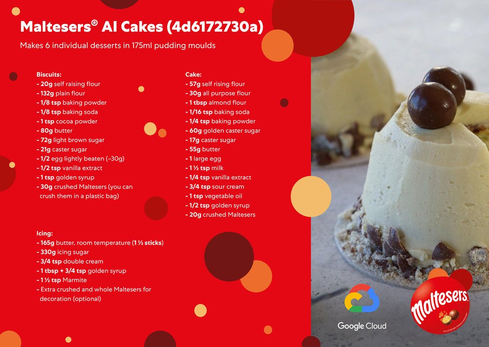
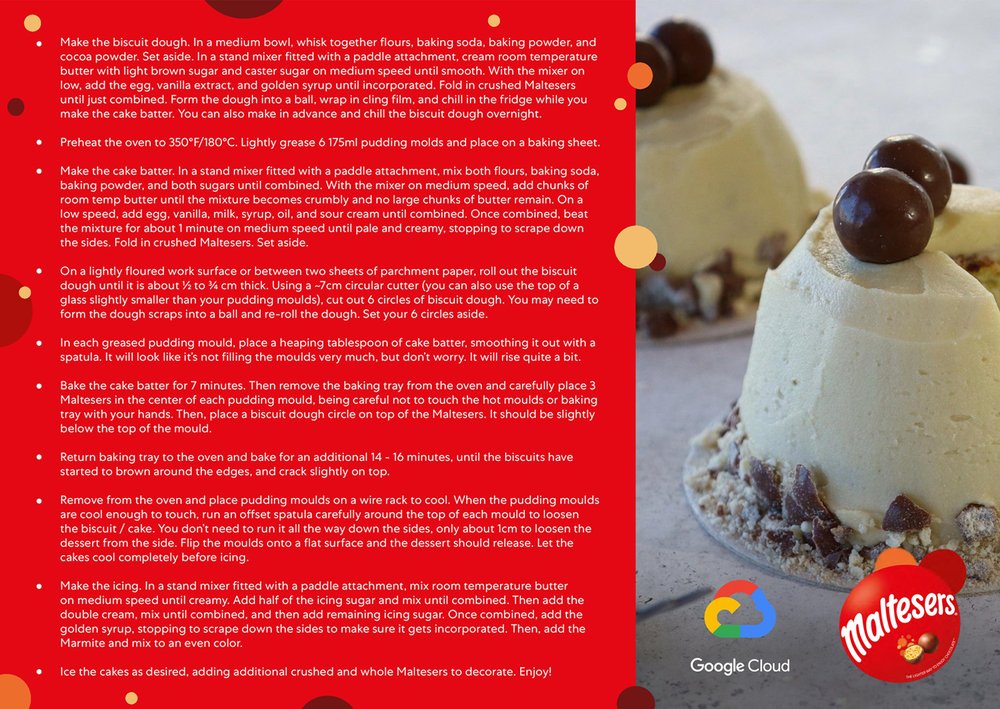


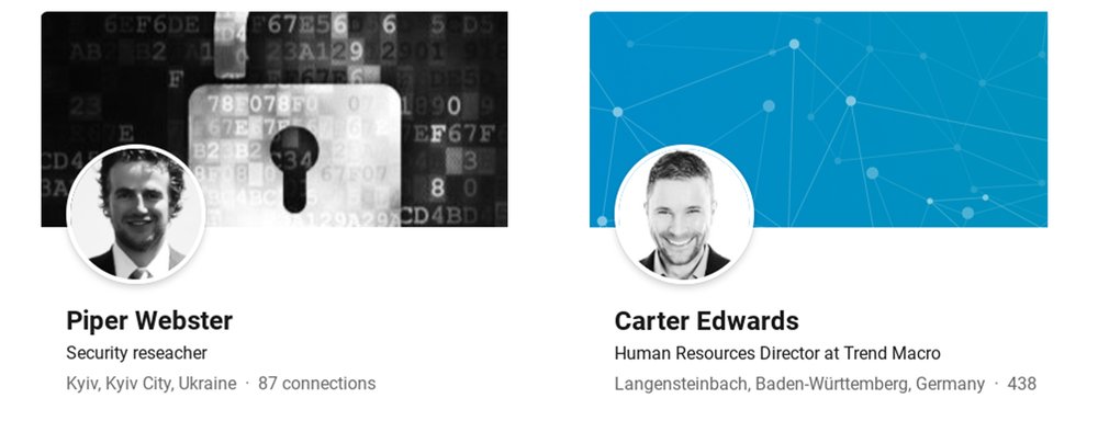
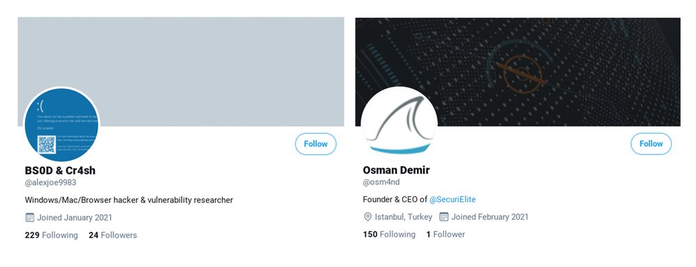
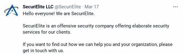
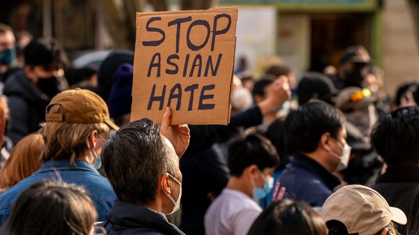
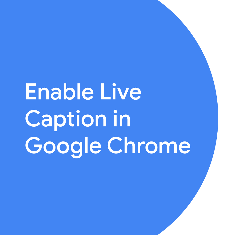
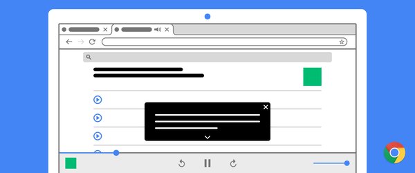
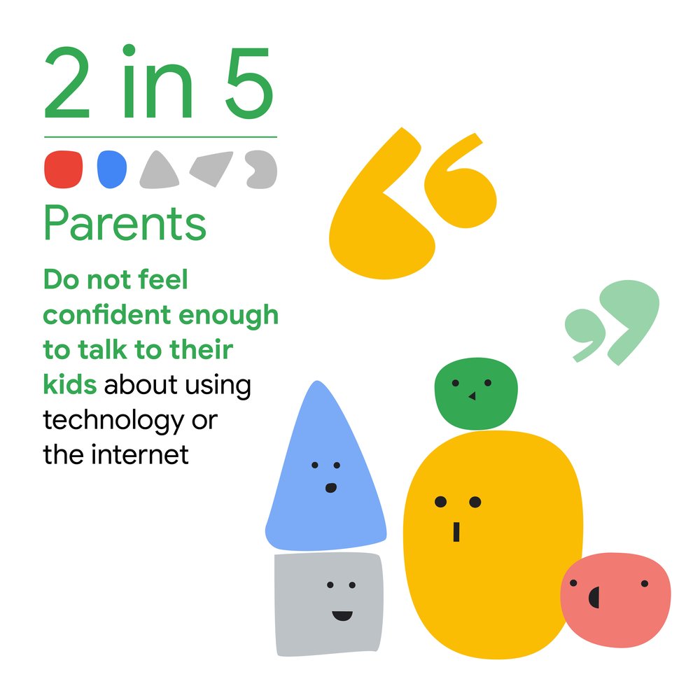
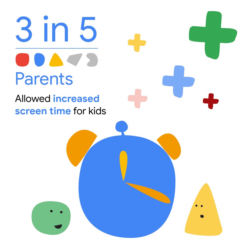
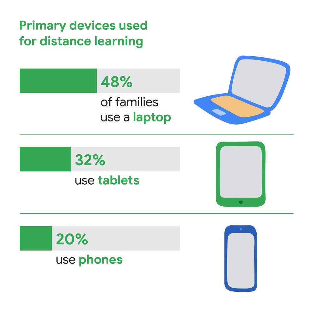
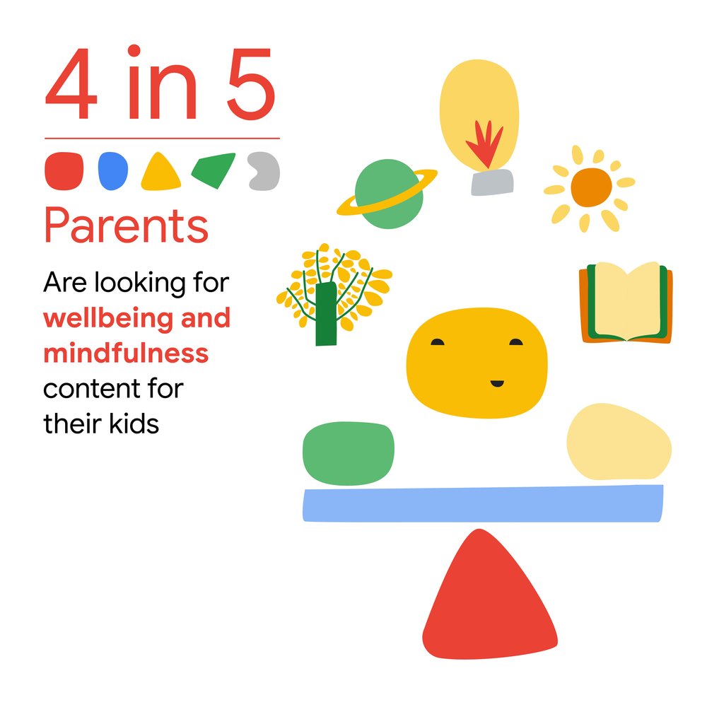
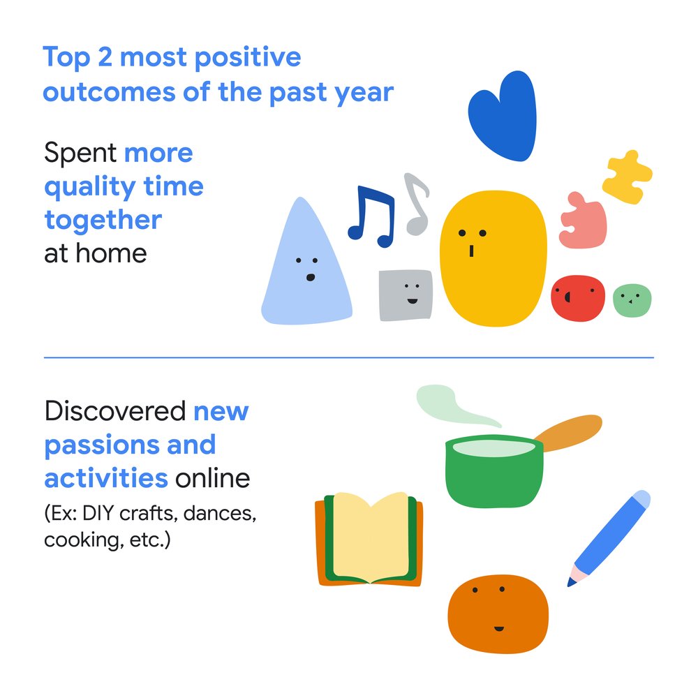
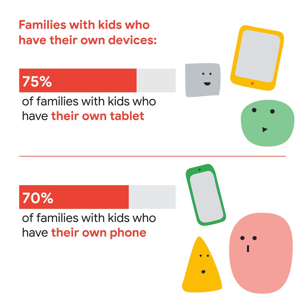
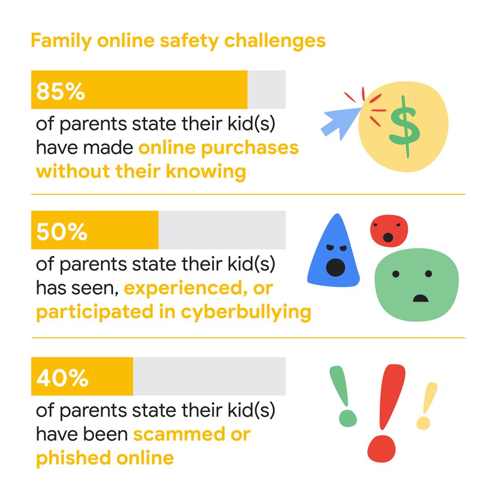


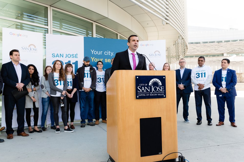


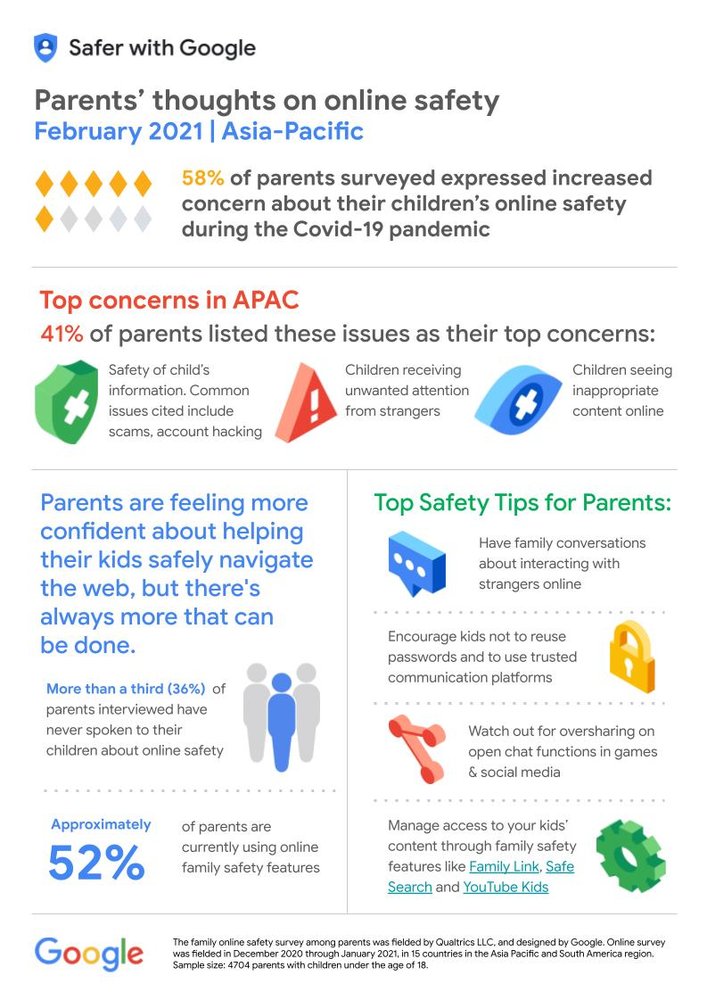

 Late last year Dan Ford launched a Kickstarter to create a board book (i.e., a children’s book printed on paperboard) about map projections called Map Projections for Babies. Presumably intended to be in the same vein as other board books on surprisingly advanced science topics (Chris Ferrie has a whole series of them; Quantum Computing for Babies is a typical title), Map Projections for Babies “explains how we unwrap the round Earth to make flat maps. This guide for babies (and their loved ones) describes a complex concept in kid-friendly terms. […] This project began last year, when I was inspired threefold by my daughter’s curiosity, my love for maps, and a growing number of board books that condense complex concepts for babies.” The Kickstarter was successful, the book is now at the printing stage and is on track for delivery in April; additional orders will be accepted at some point. [Geography Realm]